
After several blasts of snow and ice over the last few weeks, a quieter pattern is forecast through mid-week. By late week, southerly flow will be strong, and temperatures will soar into the upper 50s (and perhaps into the lower 60s for some). Beyond this, there are indications that arctic air will plunge into the northern half of the U.S., but this is not certain.
Recent model runs are in good agreement for a late week warm up. While this morning’s GFS model run shows a closed, upper-level low nearby, it also shows abnormally warm temperatures (indicated in red and purple) over the eastern two-thirds of the nation:
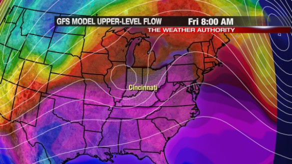
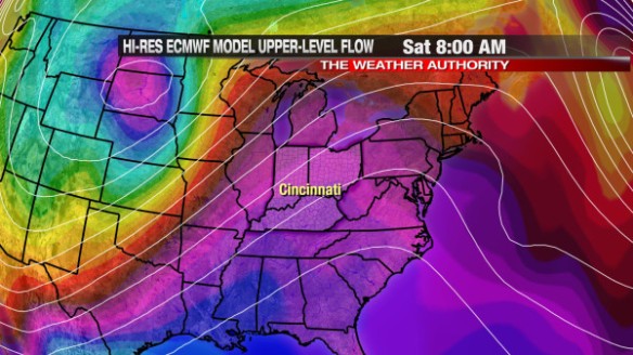
The GFS dissolves this upper-level low by Saturday morning, and so does the latest run of the ECMWF. This morning’s ECMWF run also has abnormally warm air along the spine of the Appalachians early Saturday:
While it will be warm, it will be wet at times and rather cloudy. For now, the best chance for rain in the week ahead is Thursday and early Friday. Models disagree on the exact timing and strength of the system moving through this weekend.
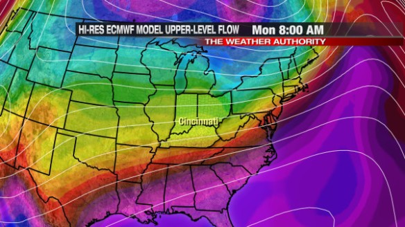
Beyond this weekend, the forecast gets very tricky. The latest ECMWF model has cold air invading from the north (indicated in blue, green, and yellow), but the true arctic air (indicated in dark blue and purple in the top of the graphic) is still in Canada by early Monday morning:
The GFS solution is a lot colder next week than what the ECMWF suggests. The GFS has been a more reliable and consistent model as of late, but the GFS has a bias for over-developing areas of low pressure and – in turn – overdoing cold plunges in the wake of them. In addition to the strength, the GFS has also been inconsistent with the timing of this potential arctic outbreak next week. Despite the GFS continuing to show a large blast of arctic air sometime next week, I remain skeptical.
When it comes to arctic outbreaks, the last holdout in the model world is usually the Canadian – specifically the Canadian Ensemble mean. An ensemble is essentially a bunch of models with the initial conditions changed slightly; an average of all of the ensemble members usually gives an accurate indication of what will happen in a broad sense weather-wise. The last Canadian Ensemble mean plot shows arctic air (indicated in blue and light blue) over Canada and some of that arctic air spilling into the Mississippi and Ohio Valley:
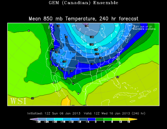
If you take this model output at face value, next week looks rather cold around Cincinnati, but not extremely cold. Because the plot above is an “average,” it’s difficult to see localized extremes in temperature; nonetheless, the idea is clear: there is the potential for large cold blast next week, but the specific timing and positioning of this cold air is uncertain. I don’t see support for a large arctic outbreak like many have advertised. My experience tells me large arctic outbreaks are not likely until they are supported by the Canadian Ensemble.
The latest ECMWF Weekly model (that came out Thursday night) shows above average warmth (indicated in bright green) for the Tri-State from Tuesday to next Monday:
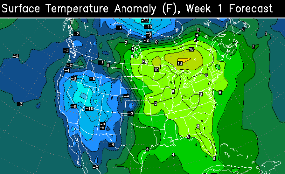
The latest ECMWF Weekly model also keeps us in above average warmth from January 15-23:
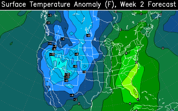
The ECMWF Weekly wants to keep the core of arctic air over the Rockies and southern Canada, working against recent GFS model solutions of a large arctic outbreak next week.
With confidence, I can say next week looks colder than this week. I’m leaning towards a prolonged colder-than-average stretch next week over a major arctic outbreak (with highs consistently in the 20s) like the GFS model suggests.