
The flurries and snow showers passing through the Ohio Valley today will end tonight, and clouds will gradually dissipate this evening and overnight.
With high pressure nearby tomorrow, our attention turns to a late week system that looks to bring us accumulating snow. Temperatures will be around 20° early Friday and around 30° by late Friday afternoon; this is certainly cold enough to support snow and set concerns for freezing rain, sleet, and rain aside…at least for now.
When it comes to forecasting an amount of snow, meteorologists often see what liquid amounts computer models are suggesting and then convert that liquid amount to a snow amount based on temperatures. Here is what the latest forecast models think for liquid amounts Friday morning through Friday night:
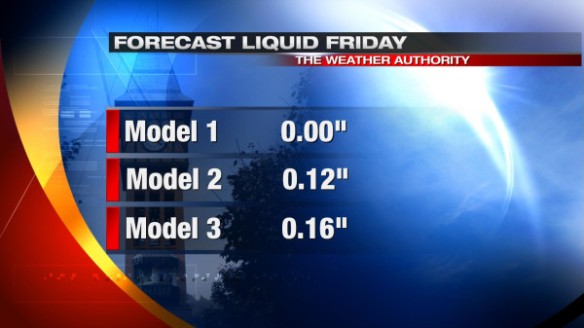
Notice one model has no precipitation for our area Friday. We are ignoring this model for now. Because temperatures will in the 20s Friday, snow to liquid ratios will be roughly 15:1 to 20:1; in other words, temperatures Friday suggest forecast liquid amounts need to be multiplied by 15 or 20 to get snow amounts. When the calculations are made, here’s approximately how much snow this morning’s models are suggesting for Friday:
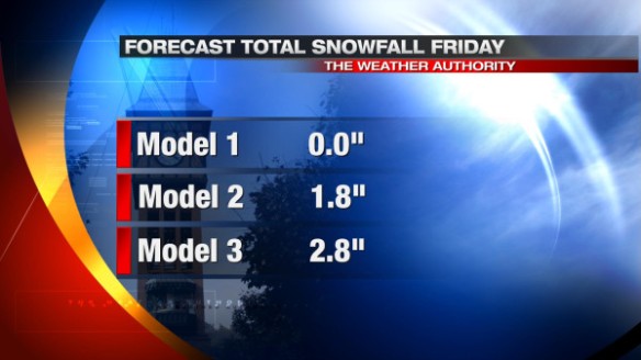
Remember, these are computer model suggestions, not a forecast. Given the good consensus among models (with the exception of the model that gives us nothing and is being thrown out for now), we are fair game for a couple of inches of snow Friday.
Specifics on snow amounts in the Tri-State will likely have to wait until tomorrow. Stay tuned!