
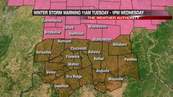
A Winter Storm WARNING has been posted for Fayette, Union, Franklin, Butler, Warren, and Clinton County from late Tuesday morning through 1pm Wednesday:
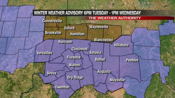
The rest of the Tri-State will be under a Winter Weather Advisory from 6pm Tuesday to 1pm Wednesday:
Light rain (especially after midnight) will mix with flurries tonight, and Tuesday’s forecast calls for mainly rain with some flurries in the morning. With ground temperatures at or above freezing tonight, accumulating snow is not a concern; accumulating snow, however, is likely late Tuesday night and early Wednesday.
For being this close to the Tuesday night/early Wednesday event, there is still great uncertainty about where the heaviest snow will fall in the Ohio Valley. The latest model data have trended farther south with the axis of heavier snow. Last night, it appeared the heaviest snow would be in northern Ohio and Indiana; that axis of heavier snow now looks to set up closer to I-70.
I will show you the latest model runs not to highlight specific amounts but instead to show you model uncertainties and where the heaviest snow – at least for now – will fall. Remember, this is NOT a forecast!
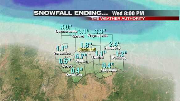
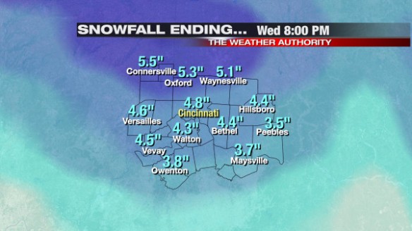
Our in-house model Precisioncast gives a wide range on totals from north to south; it suggests the southern-most communities in the Tri-State will see minor accumulations while many north of the Ohio River see at least a couple of inches of snow through Wednesday evening:
Another one of our in-house models, Microcast, gives most in the Tri-State about an inch of snow, but also blasts some Tri-State communities with snow:
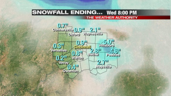
This morning’s ECMWF model – which has consistently been the most aggressive with snowfall amounts Tuesday night and early Wednesday – gives the Tri-State anywhere between a couple and a few inches of snow:
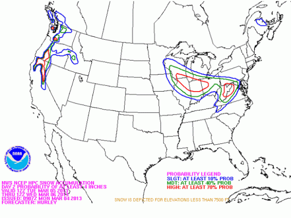
The latest outlook from NOAA’s Hydrometeorological Prediction Center gives the northernmost parts of the Tri-State a moderate risk of seeing 4″+ of snow through 7am Wednesday morning; according to this forecast, the rest of the Tri-State has a slight risk for seeing 4″+ of snow:
My Latest Forecast
For now, I’m thinking we’ll get a couple inches of snow Tuesday night and early Wednesday. The highest snowfall totals will likely be north and northeast of Cincinnati, and the lowest totals will be focused south and southwest of the Queen City. Visibilities will likely be reduced by snow falling early Wednesday. Snow will likely be wet and slushy instead of dry and powdery with this event.
This blog will be updated tomorrow…or as needed!