
If you’re concerned about the risk for severe storms Wednesday, Wednesday night, and very early Thursday, you should be. If you’re scared, you shouldn’t be. If you’re not prepared for the threat for severe storms, you should be.
As I mentioned in my blog post early Tuesday evening, the Storm Prediction Center has issued MODERATE risk for severe storms in the Tri-State from 8am Wednesday to 8am Thursday; the biggest concern for severe storms will be Wednesday evening and overnight.
What exactly is a “Moderate Risk?” Here are the differences on the Slight, Moderate, and High Risk outlooks issued by SPC:
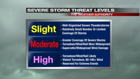
March 2, 2012 was a High Risk day, and it – unfortunately – verified with numerous violent tornadoes and more than a dozen killed in our area. We are not in an SPC High Risk Wednesday or Wednesday night, but we are in an SPC Moderate Risk, suggesting the threat for strong and severe storms is significant.
When you take data from this morning’s NAM forecast model for Wednesday night and compare it to similar weather event and setups in the past (using St. Louis University’s CIPS Analog Guidance), the top 15 closest matches suggest an elevated risk for severe storms. Here are all of the SPC storm reports from those top 15 closest matches:
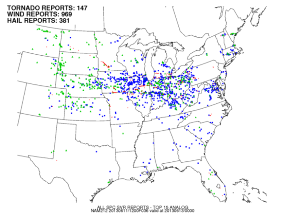
All of the blue dots are damaging wind reports. Blue dots far outweigh green dots (severe hail reports) and red dots (tornado reports), so history would suggest this pattern will give us more damaging wind reports over other forms of severe weather.
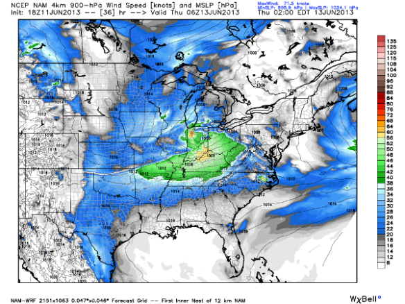
This is supported by this afternoon’s (18z) WRF model, which suggests winds 2,000-3,000 above Cincinnati at 2am Thursday morning will be in excess of 60mph:
This same run of the WRF shows storm relative helicity (a measure of how likely storms are to spin) values are elevated tomorrow night, but not abnormally high:
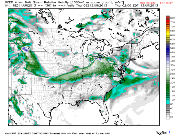
These numbers support a marginal tornado threat Wednesday night and early Thursday. With the winds just above the ground very strong out of the west tomorrow night and a strong surface wind out of the southwest, there is little directional shear (needed for tornadoes) but strong speed shear (supporting a damaging straight-line wind threat).
What will the system look like on radar? There is still a fair amount of uncertainty regarding this, but most models suggest a bowing line of thunderstorms will be pushing through the Ohio Valley Wednesday evening and early Thursday. Our in-house WRF-ARW model shows a line of showers and thunderstorms moving into our area around 2am Thursday:
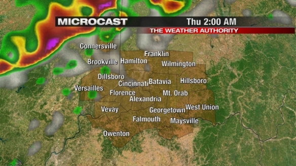
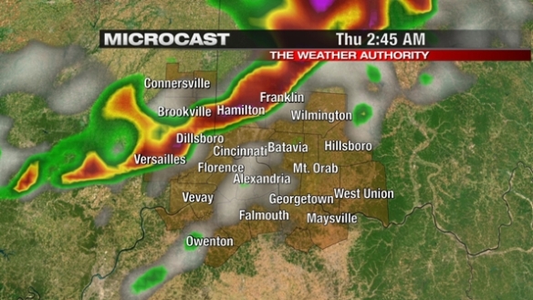
…and moving into the heart of the Tri-State nearing 3am:
…and pushing south by 8am Thursday morning:
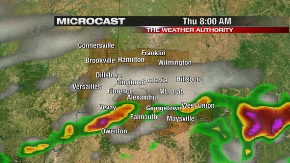
This is just one model’s thoughts on what will happen tomorrow night. I suspect this model is off on timing given that most storms tomorrow night will generally be moving northwest to southeast at 40-50mph. This model, however, supports a bowing line of storms pushing through over a line or clusters of supercells.
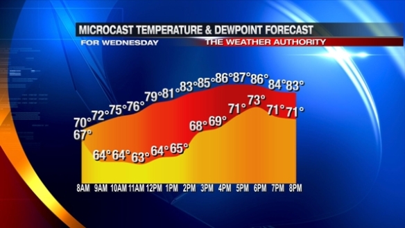
The elevated severe storm risk is being driven by strong southwesterly flow tomorrow, pumping warm moist air into the Ohio Valley. While the raw numbers from this morning’s Microcast run are off (especially for temperatures and dewpoints late in the day Wednesday) , the model clearly shows Wednesday and Wednesday evening will be warm and humid:
There is still a lot to be resolved about the severe weather threat in the next 48 hours. As with most severe weather events, the threat often changes hour-by-hour as the event draws closer. We don’t yet know exactly what shape these storms will take, and the timing of the peak severe weather threat hasn’t been pinned down yet. We do, however, know that damaging straight-line winds appear to be the main threat, and the secondary threats will be tornadoes, large hail, and flooding.
Are you prepared for the possibility of severe storms? Here are some things to consider:
– Is your NOAA Weather Radio working and programmed properly?
– Are there fresh batteries in your NOAA Weather Radio, and it is also plugged into a wall outlet?
– Do you have a flashlight with fresh batteries, hard-soled shoes, bottled water, and a first aid kit in your basement?
– Do you and your family know where to take cover if a warning is issued?
– If you’re going to be away from your home tomorrow night, do you know where to take cover if needed?
– Do you have more than two ways to get watch and warning information (NOAA Weather Radio, phone app, text messaging service, Twitter, Facebook)?
Please be prepared and weather aware for storms in the next 48 hours. Now is the time to plan; don’t wait until the storms hit!