
As new model runs complete, the overall forecast remains unchanged. At this point, we are nowcasting the event. Satellite, radar, and surface observation trends are becoming much more important as tonight’s rain and snow event nears.
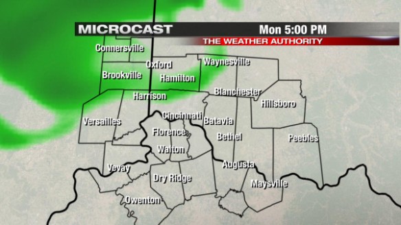
In my blog post yesterday, I discussed how rain would begin around dinner tonight, continue through the evening, transition to snow nearing and especially past midnight, and snow would end nearing sunrise Tuesday. Microcast shows widely scattered showers developing (especially north and northwest of Cincinnati late this afternoon) in the Tri-State:
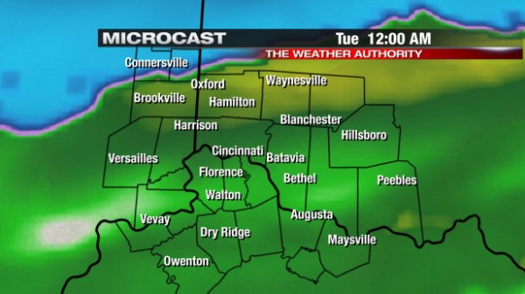
Microcast has only rain in the Tri-State until late evening, when the transition from rain to snow will begin north and northwest of Cincinnati:
After midnight, all rain will transition to snow, and snow will gradually push south and southeast nearing sunrise Tuesday. By 6am, Microcast shows snow showers south of Cincinnati:
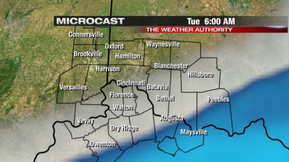
If this model – and all of the forecast models that push snow mainly south of Cincinnati by 6am – verifies, the first half of the morning commute tomorrow will be more problematic than the second half. By lunchtime Tuesday, the arctic front (and the snow along it) will be to our south, and temperatures will only be in the mid 30s.
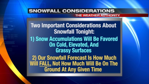
Up to 1″ of snow is forecast in the Tri-State through Tuesday morning. With temperatures around freezing overnight, snow may struggle to stick in spots, and not all of it will be on the ground at once. When we say “snowfall accumulation tonight,” there are some important considerations included in that prediction:
The morning commute tomorrow will be tricky. If you’re going to work early tomorrow (especially 3:30 to 5am), be prepared for pockets of visibility-reducing snow and slick roads. After 5am, the coverage and intensity of snow will decrease from northwest to southeast, but slick spots on the roads will likely linger for at least a couple of hours after snow ends. Any snow that is able to accumulate early Tuesday morning will likely melt Tuesday afternoon, especially snow that is exposed to direct sunlight once clouds clear out Tuesday morning.
High temperatures will only be in the mid to upper 30s Wednesday and Thursday. Low temperatures will likely drop into the low to mid 20s early Wednesday and Thursday morning.
Now is the time to prepare for the snow and cold. While a major snow storm is not expected tomorrow, the first snow of the season (and really any snow event in the Tri-State) usually takes some off guard. Allow for extra time getting to work or school tomorrow morning!