
El Niño is the warm phase of an atmospheric and oceanic oscillation called ENSO, or the El Niño Southern Oscillation. The word “oscillation” implies that El Niño comes and goes on a semi-regular schedule (every couple to few years). El Niño is best visualized as abnormally warm water in the equatorial Pacific Ocean:

This abnormally warm ocean water leads to rising air directly above it. This rising air leads to atmospheric changes around the world, including a shift in jet streams. Changes in jet streams around the world means changes for where cold and warm air goes and where fronts go.
El Niño is not the only oscillation that controls weather around the globe. The Pacific Decadal Oscillation, the Arctic Oscillation, and other oscillations can affect where weather systems go and how strong they are.
El Niño impacts weather patterns in North America, so El Niño can affect the weather the Tri-State sees. El Niños typically occur during the winter, so looking at previous El Niño events can be helpful for understanding the El Niño currently affecting the us and the world.
What does an El Niño winter look like in Cincinnati? Most El Niño winters tend to be drier than average, warmer than average, and less snowy than average; there are exceptions! Like snowflakes, no two winters are alike.
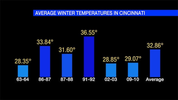
The average winter temperature (December 1st through the end of February) in Cincinnati is 32.86°. Since 1950, 3 out of 5 strong to very strong El Niños winter have been warmer than average:

The El Niño of 2014-2015 is forecast to be strong to very strong, and perhaps the strongest on record.
Winter temperatures in Cincinnati aren’t necessarily warmer than average during moderate to strong El Niño events:
El Niño winters in the Queen City tend to be drier than average, but El Niño doesn’t mean the Tri-State is exceptionally dry during the winter:
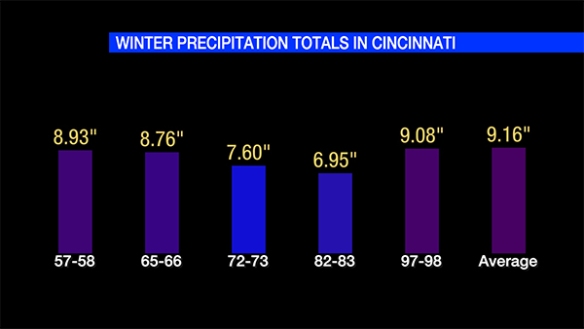
The Tri-State isn’t always drier than average during moderate to strong El Niño events. In fact, many moderate to strong El Niño winter in Cincinnati since 1950 have been wetter than average:

It is important to note that precipitation is liquid-equivalent. Snow and ice must be melted to water (and added to the rainfall total) before a precipitation total is calculated.
Does El Niño affect winters snowfall totals? Yes, but not always. Since 1950, 3 out of 5 strong to very strong El Niño winters had less snowfall than average in Cincinnati:
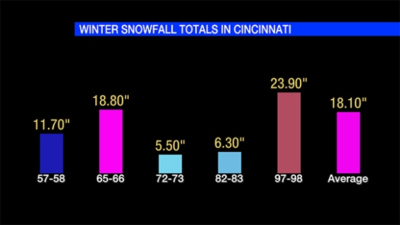
18.5″ of 1997-1998’s winter snowfall total came fell on February 4, 5, and 6 from a single winter storm. Had that event not happened, the seasonal snowfall total would have been well below average.
A full understanding of El Niño doesn’t not mean a full understanding of the winter forecast. A single winter storm can tip the scales to the other side of average.
As always, forecast change. Seasonal forecasts can change drastically. Use caution in using historical data to understand the future. Also, computer forecast models can struggle with long range forecasts. Know that as climate scientists and meteorologist review data, the forecast may change.