What Was The Biggest Local Weather Story Of 2012?

When you reflect on all of the weather events in the last year, what do you think was the biggest? Was it the 100°+ heat this summer? Was it the snow and ice late in December? Was it the daily rainfall records set early in the year? Was it the drought that lasted for months?

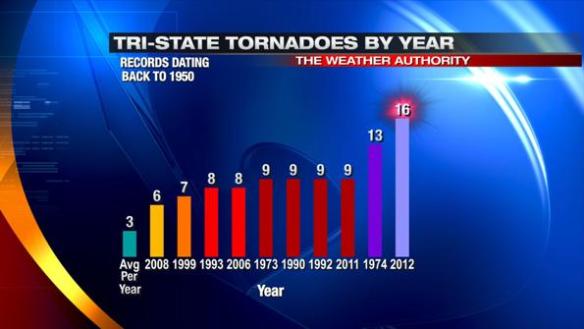
To me, undoubtedly, it was the number of tornadoes in the Tri-State (16 total). 9 of these tornadoes occurred on March 2, 2012, and one was violent (an EF4 tornado); 10 people died in that event alone. On average, 3 tornadoes are confirmed in the Tri-State each year. Here’s how the number tornadoes in 2012 stack up against records dating back to 1950:

jan1-2012tornadoes

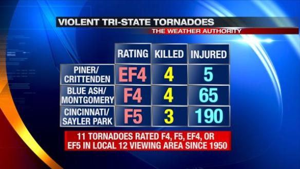
The Piner/Crittenden tornado was originally rated an EF-3 tornado, but was upgraded to a EF-4 tornado 7 days after it hit. Including this tornado, only 11 tornadoes in the Tri-State have been given an F4, F5, EF-4, or EF-5 rating since records began in 1950:

jan1-violenttornadoes

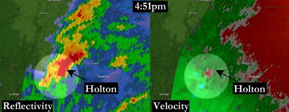
The Terminal Doppler Weather Radar (TDWR) used to track storms around the Cincinnati/Northern Kentucky International Airport captured the tornadic supercells on March 2, 2012. In this scan from 4:51pm, a hook echo (left) and strong rotation (green next to red on right) were apparent with the storm that produced EF-3 tornado damage in Holton, Indiana:

TCVGholtonZandV2jpg

The TDWR also captured strong rotation (on right) and a debris ball (on left) with the tornadic supercell that hit Piner, Kentucky:

pinertdwrZandV-ZandVshadedjpg

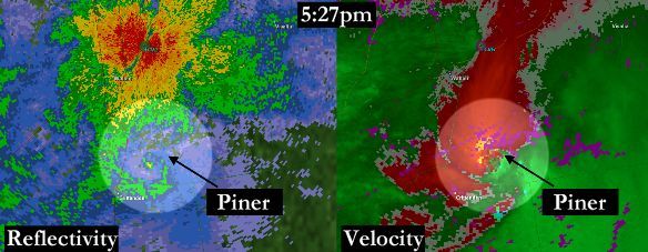
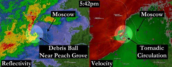
A debris ball is a “ball” of higher radar returns caused by larger objects (debris) being lofted by a tornado.

This supercell continued into Campbell County, producing another debris ball and tornado signature near Peach Grove, Kentucky:

peachgrovetcvgZandVwithmoscowjpg

In total, 10 people died in the Tri-State as a result of this event. The first ever Tornado Emergency was issued on March 2nd, 2012; another one was issued shortly after the first one.

Despite March 2, 2012 being the deadliest severe weather day in the Tri-State since records began in 1950, the number of Tornado Warnings issued in that same area (26) did not break a yearly record (36 set in 2011):

jan1-2012warnings

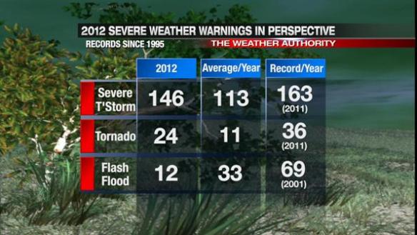
The number of Severe Thunderstorm and Tornado Warnings in the Tri-State were both above average. Given the drought most of the year, Flash Flood Warnings were rare.

Many in the United States – including the national media – focus on only the Henryville tornado when March 2, 2012 is discussed. While 11 people tragically died from the tornado that tracked north of Louisville that day, March 2, 2012 was more than just this tornado. The people who were injured and killed by tornadoes on March 2nd in southwest Ohio, southeastern Indiana, and northern Kentucky should not be forgotten.

December 26th Winter Storm Verification & Reflection

The biggest storm of the 2012-2013 winter season so far is behind us. Official records for Cincinnati are taken at the Cincinnati/Northern Kentucky International Airport; 2.9″ inches of snow fell at the airport, making today the snowiest single day since January 20, 2011 (707 days ago) when 5.6″ of snow fell. As promised Monday and Tuesday, there would be a wide range of snow and ice amounts in the Tri-State, and there were. Here’s a map of selected snow and ice accumulations (all that can fit on the map) in southwestern Ohio, northern Kentucky, and southeastern Indiana through 9pm:

dec27-verif

There were some late storm totals:
Blanchester: 2.5 snow, 0.1″ of freezing rain accumulation
5 miles west of Cornith, Kentucky: 0.3″ snow accumulation
3 miles east of Cheviot, Ohio: 3.3″ snow accumulation

This is the objective analysis from NWS Wilmington as of Thursday morning. This report includes reports collected yesterday and reports from spotters that regularly call into the NWS each morning:

dec27-nwstotals

So how accurate was the forecast from Tuesday night? Here’s what I had on the air at 11pm Christmas night:

dec27-forecast

Only very subtle changes were made to John Gumm’s forecast at noon Christmas Day for the 4pm-11pm newscasts. More than 24 hours out, John had nearly every town in a correct snow and ice accumulation snow total band. What an outstanding forecast! After afternoon and morning model runs, I made very few changes to his forecast (the biggest being the extension of the 6-10″ band into northern Ripley County and central Franklin County). The title on this graphic should read “snowfall and ice” instead of just snow, but most saw 0.1″ of freezing rain accumulation or less. Brookville is the outlier on the map, but totals around Brookville ranged from 6″ to 9″ Wednesday afternoon. Considering there was blowing and drifting snow along with freezing rain and rain mixing in along and south of I-71, the forecast worked out quite well. Forecasts like these don’t always work out this well, but I’m thankful this one did.

On Monday night, snow and ice amounts did not look like they did Tuesday. I did not release snow and ice amounts Monday night. While some may have been wondering “where is the snow forecast?” it was the right decision to wait until there was some agreement among the models.

On a personal note, the hardest part of the day was hearing this story: http://www.local12.com/news/local/story/One-Person-Dead-After-Crash-on-I-71/C9HaT52MzkapO7aJEUQyLQ.cspx

While it is sad to hear of a crash that was most likely weather related, it was even harder to see this knowing that I highlighted the blizzard – or at bare minimum “blizzard-like” – conditions in this area as a band of heavy snow came through on-air. This is what the Buckeye Traffic camera looked like at the intersection of I-71 and Fields Ertel Road around 4:40pm Wednesday:

dec27-fields

Roads were mostly snow covered, and the visibility was significantly reduced due to blowing snow. I told people on the air Wednesday to not drive in this area (and other areas with blowing snow) if they didn’t have to or until the band of snow had moved out of the area. Unfortunately, an 18-year-old woman lost her life Wednesday along this road, and this upsets me. It is hard to reach people in their cars, but I wish I could have.

On a lighter note, I want to thank all of our spotters that gave us snow and ice reports through the morning, afternoon, and night Wednesday. This job is much easier with your support and help!