A Breakdown Of Today’s Severe Weather Potential

Morning showers and storms have stabilized the low-levels of the atmosphere and have prevented temperatures from rising significantly. As of 11am, most in the Tri-State are in the 70s:

jun15-11amtemps

Sunshine is, however, returning to the Tri-State per the 10:45am visible satellite image:

jun15-1045amclouds

Note a boundary (in the form of clouds) from southern Indiana back close to Dayton. The Ohio Valley radar image as of 11:15am shows showers and storms moving east and southeast of Cincinnati:

jun15-1115amradar

While the boundary now from southern Indiana into west-central Ohio is moving southeast and will trigger isolated to scattered storms early this afternoon, the main axis of instability is in northwestern Indiana and is dropping southeast. This secondary front will be the one that triggers storms later this afternoon and early this evening.

The Storm Prediction Center has the entire Tri-State in a slight risk for severe storms through this evening:

jun15-spc

This is mainly for the potential of damaging straight-line wind. Secondary threats include large hail and localized flooding, especially with dewpoints in the upper 60s and lower 70s as of 11am. Here’s a breakdown of severe weather threats through this evening:

jun15-impacts

The most likely time for severe weather today centers between 3pm and 9pm, especially between 5pm and 8pm.

Clusters of rain and storms will develop to our northwest later today, gradually coalescing into a line as it moves southeast. The afternoon forecast calls for showers and storms to redevelop this afternoon. Highs today will be in the mid to upper 80s, and it will be steamy:

jun15-afternoon

Showers and storms will diminish and end this evening. Strong and severe storms will be favored early:

jun15-evening

Be alert, friends!

Was It A Storm That Wasn’t In The Forecast? Nope.

If you were watching Ohio Valley radar yesterday afternoon, you might have noticed radar returns in southern Indiana. Were these showers and storms bubbling up due to temperatures rising through the 70s? Did I bust a forecast?

Despite what you may think, the same device that suggests I blew the forecast also suggests I got it right. Modern radar is a power thing when used to it’s fullest potential.

First, is it realistic to have radar returns in this area? A visible satellite snapshot of the Ohio Valley shows cumulus clouds in southern Indiana at 5:15pm yesterday afternoon:

jun8-515pmclouds

We need clouds to have showers and storms, so the returns on radar could be precipitation. Notice there are no towering clouds in the area though (unlike in northern Ohio were showers and storms were in progress with higher instability); satellite imagery leads us to believe there was just a sea of shallow cumulus clouds yesterday afternoon in southern Indiana.

Here are the radar returns as viewed by the National Weather Service Doppler radar in Indianapolis late yesterday afternoon. The reflectivity (commonly shown on television or apps) is on the left, and correlation coefficient (showing the relationship between the height and width of objects like raindrops, hail, or debris sampled by radar) at the right. Blue values of correlation coefficient here suggest these returns are particles of different shapes and sizes and likely not raindrops, hailstones, or something related to meteorology:

jun8-chaff600

Radar cross sections show these returns did not extend well into the atmosphere. Here’s the reflectivity cross section from NWS’ Indianapolis’ radar at 5pm ET yesterday:

jun8-5pmreflectivity

These returns are relatively close to the ground (below 10,000′). Here’s the correlation coefficient cross section at the same time:

jun8-5pmcc

Blue values here suggest these radar returns are likely not raindrops or hailstones. So what could it be?

The radar returns become apparent around 4:40pm in the afternoon. See the green dot in the reflectivity at the left with blue (low) correlation values in the same area at the right:

jun8-440pmradar

This is surprisingly close to Camp Atterbury in Indiana. The military is known for dropping chaff to scramble radar and serve as a countermeasure. Low (blue) correlation coefficient values on radar are common with smoke plumes and military chaff. The meteorological environment did not support showers and storms, so military chaff is the most likely bet.

Need some additional evidence? Fast forward to this morning. Here’s the visible satellite snapshot as of 8:45am Wednesday:

jun8-845amclouds

Notice no clouds in the sky. There were still no clouds over southern Indiana as of 10:30am ET.

Yet there is something on radar in the same area near Camp Atterbury as of 10:20am ET:

jun8-1020amradar

Reflectivity values are high and correlation coefficient values are low in the image attached. It looks like chaff is the culprit here. Remember, we need clouds to have showers and storms, and there were no clouds in the sky when these returns were on radar.

Radar is a powerful tool if you review the data thoroughly. Even as a meteorologist, it’s easy to fall into the trap of seeing radar returns and assuming showers and storms are developing. Radar can sample dirt, bugs, plumes from wildfires, tornado debris and precipitation. Things aren’t always as they seem!


Historical Perspective On This Morning’s Freeze

A freeze in the second half of May in Cincinnati is rare. While rare, freezes and frosts and do occur in late May.

The official low temperature this morning at the Cincinnati/Northern Kentucky International Airport was 31°. This sets a new record low temperature for May 16th; the previous record for May 16th was 32°, set in 1997. Low temperatures in the low to mid 30s were widespread this morning:

may16-lowt

Inside the I-275 loop, temperatures were slightly warmer due to the urban heat island effect (more building/concrete to retain heat):

may16-lowtm

Notice Okeana dropped to 28°. Two weather stations just north of Lebanon reported low temperatures of 29° and 28°. Several sites reported a low of 30° or 31°.

How rare is a low temperature of 32° in mid or late May in Cincinnati? Here are the latest spring dates in the Queen City with a low temperature of or below 32°:

may16-latestfreeze

Notice that today’s low of 31° is the 3rd latest spring freeze date on record (back to 1871).

Frost can occur at various temperatures, but 36° or below is a good threshold to use for frost. Using 36° as a baseline, here are the latest spring frost dates in Cincinnati back to 1871:

may16-latestfrost

Today’s low of 31° ties as the 9th latest spring frost date in the Queen City. A freeze (which we had this morning) implies widespread frost.

I am cautiously optimistic that this morning will be the last freeze and frost of the season. There are no forecast overnight lows in the 30s through this weekend. Additionally, history suggests we’re safe from a freeze or frost once we get into June!

What You Need To Know About Today’s Severe Weather Threat

The Tri-State is in a slight to enhanced risk for severe storms this afternoon and evening. This is the highest threat for severe storms we’ve had so far in 2016.

The latest Storm Prediction Center outlook has the enhanced risk (the highest risk for severe storms over and southwest of Cincinnati this afternoon and evening; strong and severe storms are (slightly) less likely to the northeast and north of Cincinnati:

may9-noonspc

I encourage you to focus not on the severe threat category for which you live; instead, know that the threat for severe storms is higher in Cincinnati and points south and southwest of Cincinnati and slightly slower from Middletown to Hillsboro.

Based on radar, satellite, and model trends, it appears the highest threat for severe storms will be highest between 3pm and 10pm today:

may10-impacts

What might the radar look like at various times today? One model, the High-Resolution Rapid Refresh, seems to have a decent grasp on rain and storm placement now. Here’s what it suggests the radar will look like at 2pm today:

may10-2pmradar

Notice the round of showers and storms that came through late in the morning exiting the Tri-State completely (to the northeast) by 2pm.

Forecast radar at 5pm shows showers and storms becoming more numerous:

may10-5pmradar

Forecast radar at 8pm shows showers and storms bowing and gradually pushing east of Cincinnati:

may10-8pmradar

By 11pm, the High-Resolution Rapid Refresh model shows storms diminishing and pushing east of I-75:

may10-11pmradar

Be prepared! Some storms may produce damaging straight-line wind and large hail. The strongest storms in the Ohio Valley will be capable of producing flash flooding and tornadoes.

11:20am Weather Update – Including Today’s Severe Threat

Feeling stuffy? The pollen count is high as of 10am this morning…

mar24-aq2

Breezy and windy days tend to have an elevated pollen count. It will probably be high tomorrow.

It’s a warm windy day in the Tri-State. As of 11am, temperatures are already in the mid 60s:

mar24-temps

The wind will be sustained out of the southwest this afternoon between 15 and 30mph. Gusts may be as high as 45mph to 50mph in some Tri-State communities today. A Wind Advisory is in effect through 6pm for the entire Tri-State:

mar24-wind

Radar shows a well-defined line of rain and storms approaching from the west:

mar24-radar

Rain and storms will increase through mid-afternoon. Rain and storms will decrease early this evening. Here’s one one model thinks the radar will look like at 5pm:

mar24-5pm

While rain and storms will be moving through the Tri-State, I believe this model is too slow. The threat for strong storms will be decreasing around and after 5pm. Here’s what the same model thinks the radar will look like at 8pm tonight:

mar24-8pm

With modest instability, temperatures in the 60s, and dewpoints rising into the 50s, the Storm Prediction Center has placed the entire Tri-State in a marginal risk for severe storms through this evening:

mar24-spc

Large hail and strong to damaging-straight line wind is the main threat. The tornado and flooding threat are low at this time. Note the most likely time for any strong or severe storms today will be between noon and 5pm:

mar24-impacts

In summary, this afternoon’s forecast calls for a cloudy sky, rain, and storms with a strong wind out of the southwest:

mar24-afternoon

Rain and storms will diminish this evening as colder, drier air moves into the Ohio Valley from the west:

mar24-evening

Stay weather aware through early evening!

3:30pm Update On Severe Weather Threat

A Tornado WATCH or a Severe Thunderstorm WATCH may be issued for most of northern Kentucky and southwestern Ohio shortly.

Carroll County and all of southeastern Indiana are under a Tornado Watch through 9pm:

tornadowatch

Additional watches and warnings may be posted for the Tri-State later this afternoon and this evening. Be alert!

The radar composite as of 3pm shows a bowing line of storms to our west. These storms are moving east at roughly 45mph and are quite capable of producing damaging straight-line wind in excess of 60mph:

dec23-blog-radar

Additional round of rain and storms are likely tonight, but the round approaching from the west is likely to be the main event. It will zap a lot of the instability available for storms this evening.

The visible satellite snapshot as of 2:15pm shows breaks in the cloud both ahead of the line of storms around Louisville and also behind it:

dec23-blog-satellite

Breaks in the clouds will support to an increase in instability and stronger storms. Temperatures have been slow to rise today due to a cloudy sky, but strong southerly flow has pushed temperatures into the mid 60s for most:

dec23-blog-3pmtemps

There is still plenty of time for the record high today in Cincinnati of 66° set in 1933 to be broken or tied.

The main severe weather threat through tonight continues to be damaging straight-line wind, but tornadoes are also a secondary threat:

dec23-blog-impacts

Most of the Tri-State is still in an ENHANCED risk for severe storms through tonight, with the highest threat being southwest of Cincinnati:

dec23-blog-spc

You are encouraged to have multiple ways of getting warnings and watch information, including from a NOAA weather radio!

What You Need To Know About Wednesday Night’s Severe Threat

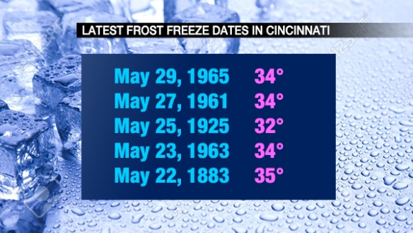
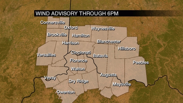
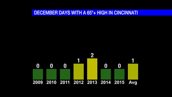
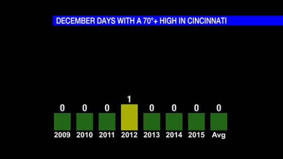
While it is most common in the spring, severe weather can happen at any time of the year in the Tri-State. A Tornado Warning was issued for Adams County at 12:30am three days before Christmas in 2013. 8 Severe Thunderstorm Warnings were issued that month. Severe weather happens in December.

The risk for strong and severe storms on Wednesday night has increased in the last 48 hours. There are several things for which we have a good understanding, and there are other things that have yet to become clear.

Specific Threats

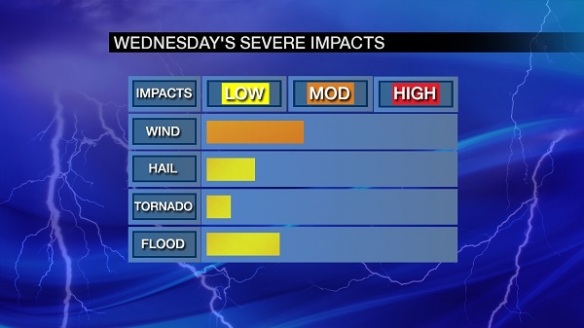
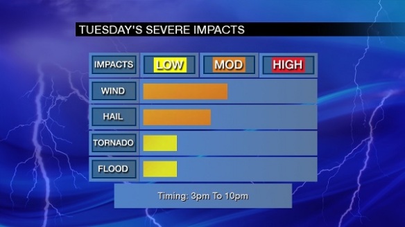
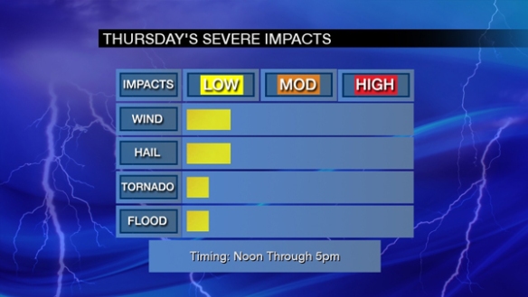
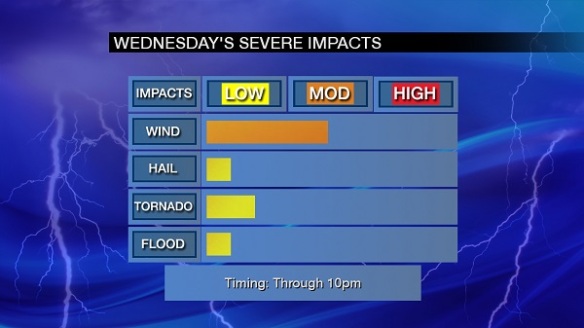
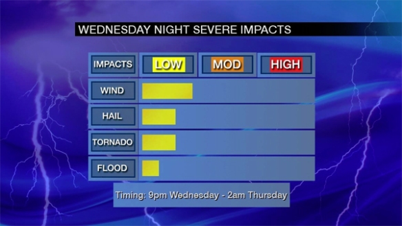
Based on recent guidance, damaging straight-line wind is the most likely severe weather threat Wednesday night. Tornadoes and large hail are secondary threats, and flooding is the least likely threat. Here is a summary of forecast severe weather impacts for Wednesday night:

dec22-wednesdaythreats

Timing

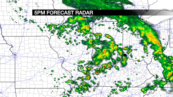
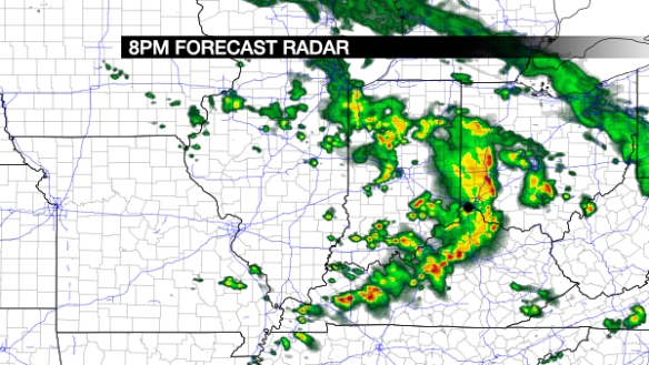
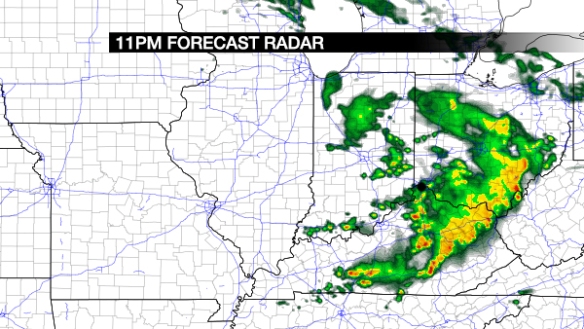
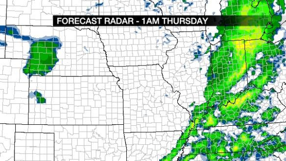
As the graphic above suggests, the most likely time for strong to severe storms to occur in the Tri-State is 9pm Wednesday to 2am Thursday. There are consistent signals that this is the most likely window for strong storms, but storms may develop earlier based on some recent computer guidance.

Locations Affected

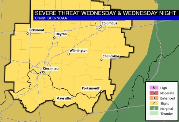
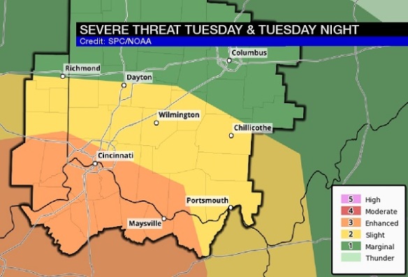
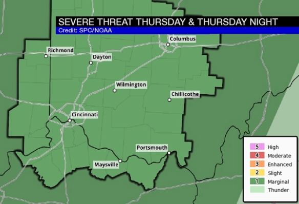
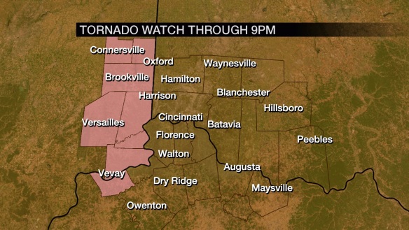
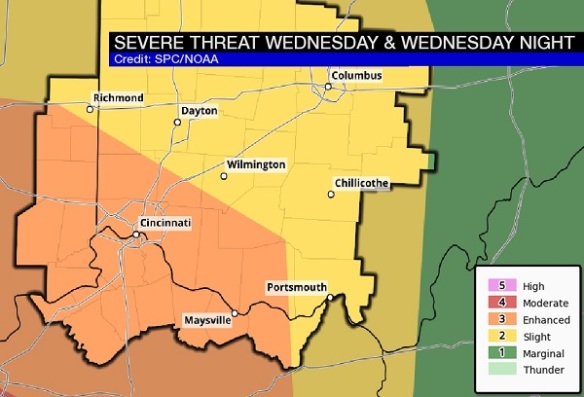
The threat for severe weather will be highest in the western half of the Tri-State Wednesday and lower for the far eastern parts of the Tri-State. All of southeastern Indiana, most of northern Kentucky, and much of southwestern Ohio is in a SLIGHT risk for severe storms per the Storm Prediction Center:

dec22-spcoutlook

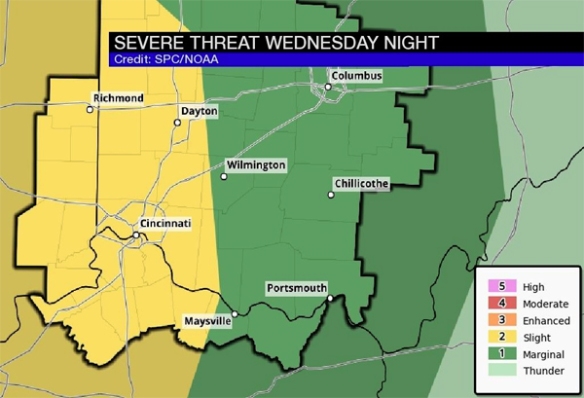
The rest of the Tri-State is a lower, marginal risk for severe storms.

Storm Modes

Initially, storms that develop in the Ohio, Tennessee, and Mississippi Valley Wednesday will be cellular but will likely coalesce into a line or lines of storms. The threat for damaging straight-line wind is typically higher with lines of storms, while discrete, individual storms can pose a higher tornado or hail threat.

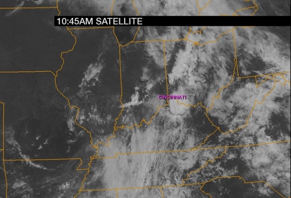
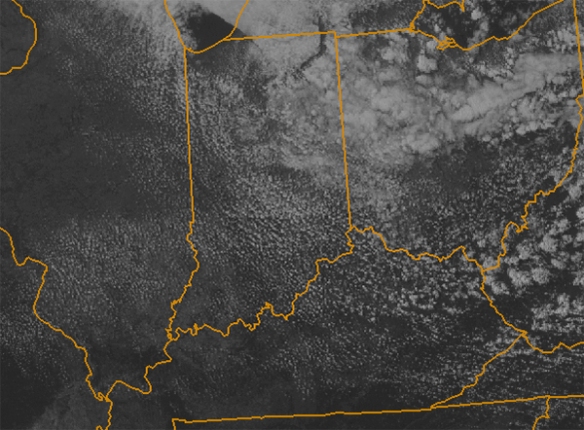
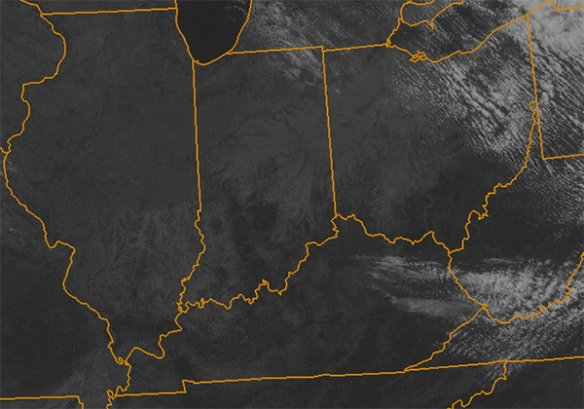
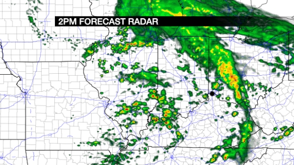
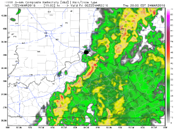
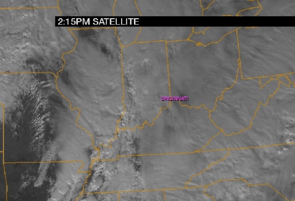
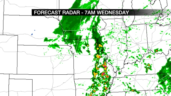
Tuesday morning’s high-resolution WRF model suggests showers – rain that starts and stops – will be will develop late Tuesday night and early Wednesday:

blog-4kmnam-7amwed

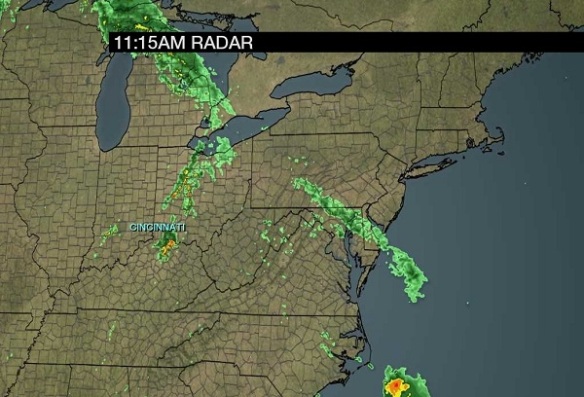
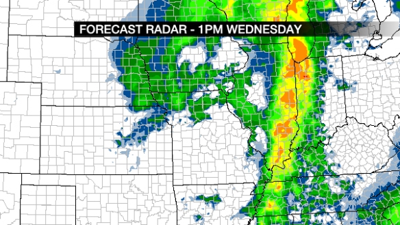
Showers and rain will let up during the afternoon, but showers and storms will redevelop near and after sunset:

blog-4kmnam-7pmwed

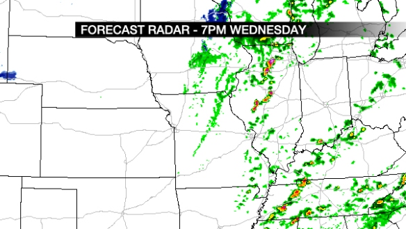
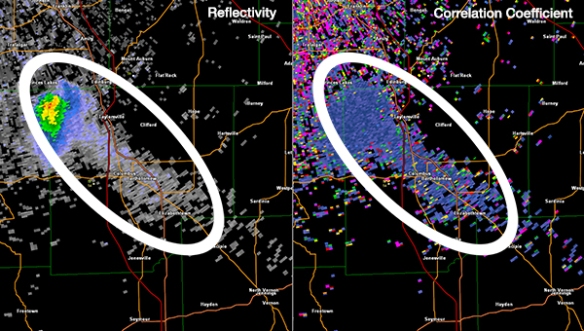
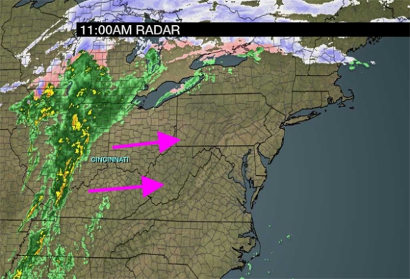
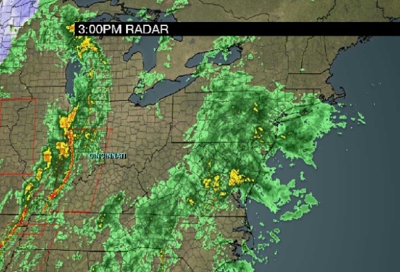
Notice that some discrete cells are developing in the forecast radar snapshot over Kentucky, Illinois, and Tennessee. The high-resolution WRF model suggests discrete cells are a possibility Wednesday night in the Tri-State:

blog-4kmnam-10pmwed

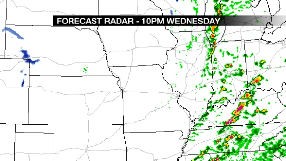
While likely overdone, this radar snapshot suggests an elevated tornado threat. However, there are other models not as supportive of this elevated tornado threat, including Tuesday morning’s lower-resolution WRF model forecast for Wednesday afternoon:

blog-4kmnam-1pmwed

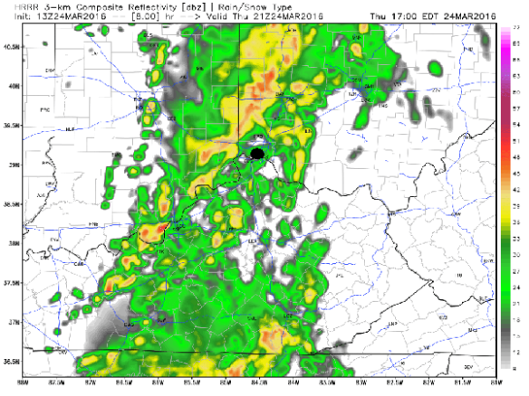
It is far more aggressive with the development of storms to our west Wednesday afternoon. It also has that line to the west meeting up with clusters of rain and thunderstorms ahead of the line near Cincinnati very early Thursday morning:

blog-4kmnam-2amthursday

Notice the differences between the high-resolution and low-resolution WRF models. This leads to a needed discussion on…

Uncertainty

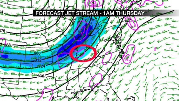
While there are discrepancies in timing and severe weather threats tomorrow night,  there is little doubt that thunderstorms will develop in the Ohio, Mississippi, and Tennessee Valleys tomorrow and continue into Wednesday evening. Tuesday morning’s WRF model suggests the jet stream (in blue) will be strong from the Plains to the Great Lakes around midnight Thursday, with upper-level divergence (lift) strongest along the Ohio River from Cincinnati to Cairo, Illinois.

blog-jet-1amthursday

As I blogged about in a similar, colder season severe weather setup on December 19, 2013 (see mention of Tornado Warning and severe weather notes above):

While instability can often have a big influence on the chance for thunderstorms, it isn’t as important this time of the year. If thunderstorms are likely […], the SHERB parameter or index can be very helpful to a meteorologist in the colder months when looking a threat for severe weather. The SHERB parameter is helpful for getting a handle on a severe weather threat in the colder months because it focuses on temperature changes near the ground, lift in the atmosphere, and wind shear instead of instability (instability tends to be low in the winter even when we get severe weather).

Why is SHERB important? Unlike summer severe weather events which are driven by high instability and less of everything else, cold season events are driven by everything else and not often by instability. SHERB is a special blend of “everything else” that is important when gauging a severe weather threat…which makes it valuable when we don’t have summer-like heat and humidity. When SHERB values are high and the chance for rain and storms is high, severe weather is often a concern.

This morning’s NAM and GFS models produce SHERB values in excess of 1 Wednesday night:

dec22-blog-sherb

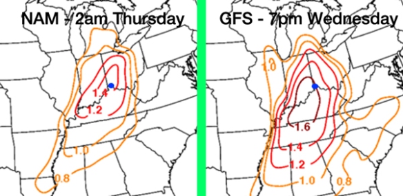
Values of 1.4 to 1.6 are rather high for this time of the year. This does not guarantee severe weather will occur, but it certainly suggests the severe weather threat is elevated.

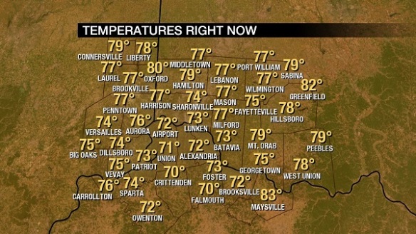
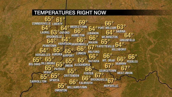
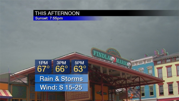
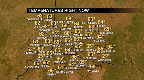
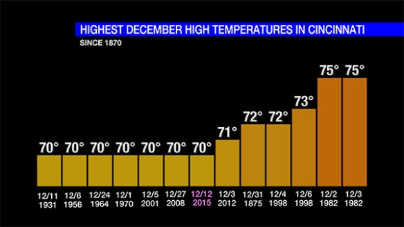
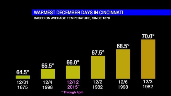
High temperatures will be in the mid to upper 60s tomorrow. The record high Wednesday in Cincinnati is 66° set in 1933. That record forecast to fall tomorrow. Record warmth, dewpoints in the 50s and 60s, and strong wind will be signals of a rising storm threat.

Be weather aware tomorrow and tomorrow night! Remember, the forecast and severe risk may change tonight and tomorrow. Stay alert for updates!

How Winters In Cincinnati With No Accumulating Snow In December Finish

There has been no accumulating snowfall so far this season or this month in Cincinnati. Accumulating snowfall is defined as 0.1″ or more at the Cincinnati/Northern Kentucky International Airport where official records are kept. From 1915 to 1947, records for Cincinnati were kept at the Abbe Observatory in Clifton; from 1870 to 1915, records for Cincinnati were taken downtown. Snowfall records before 1893 for Cincinnati are considered unofficial, but I will use them use here.

With the lack of snowfall so far in December, many are wondering if we will see snow or if winter is – essentially – cancelled. Yes, we will see snow before June comes, and no – winter is not cancelled.

At this time, there is no clear window of opportunity to see accumulating snow in Cincinnati for the rest of December. That may change; for now, however, accumulating snow is unlikely in the next two weeks.

Since 1870, there have only been 14 Decembers without accumulating snowfall: 1875, 1877, 1882, 1885, 1888, 1889, 1891, 1908, 1931, 1940, 1941, 1971, 1982, and 2011. Because of the warm, non-snowy start to summer, some are incorrectly assuming that cold and winter will avoid the Tri-State this winter. While this winter overall will likely be warmer, drier, and with less snow than average, there will be bouts of snow and cold through next spring.

In the 145 years where no accumulating snowfall was recorded during December in Cincinnati, there were only 2 (out of 14) without accumulating snowfall in the January that followed:

dec13-blog-january

An average of 4.4″ of snowfall accumulated in the Queen City during January when it failed to accumulate in December.

Of the 14 years in Cincinnati where snow didn’t accumulate during December, there was only one where snow didn’t accumulate in the following February:

dec13-blog-february

The only meteorological winter (December, January, and February) where no accumulating snowfall was recorded in Cincinnati was 1931-1932. Snow, however, did come in March and also in November of 1931.

Since 1870, there has never been a year in Cincinnati where snow didn’t accumulate in the months following a December without accumulating snowfall:

dec13-blog-janjun

On average, historical records suggests an average of 9.3″ of snowfall accumulates from January to June after a 0.0″ snowfall total for December. Based on these records, accumulating snow is extremely likely in January, February, March, April, May, or a combination of those months even if we make it to the end of 2015 without accumulating snow.

While there is little room for debate on whether we will see snowfall in the coming months, the discussion about when and how much snow will fall is endless. Cincinnati averages 18.1″ of snow each December, January, and February combined and 22.5″ from one summer to the next. For perspective, here are the least snowy June to June periods on record in Cincinnati:

dec13-blog-junjun

It is important to note that most of the Decembers since 1870 without measurable snowfall came prior to 1915, where weather records were kept in downtown Cincinnati where the urban heat island was strong. This bubble of warmer air near the city center made it more difficult for snow to accumulate.

History suggests snow will return eventually. High temperatures are forecast to be in the 30s this weekend; highs in the 60s and 70s usually come and go quickly in December.

Historical Perspective On Weekend Heat, Still No Accumulating Snow

The official high temperature in Cincinnati (at the International Airport where records are kept) today was 70°. Since official records for ‪#Cincinnati‬ began on December 1, 1870, there have only been 13 December days with a high temperature of or above 70°. Today was one of them.

When compared to today, there have only been 6 days in Cincinnati on record with a higher high temperature during December:

dec12-blog-hight

The last time Cincinnati made it to 70° during December was on December 3, 2012. There have been 7 December days in the Queen City with a high temperature of exactly 70° (most recently in 2008).

Based on the average temperature (the sum of the high and low temperatures divided by 2) through 4pm today of 66.0°, today ranks as the 4th warmest December day on record:

dec12-blog-averaget

It is important to note that today’s average temperature is not final until midnight. Temperatures will drop near 60° near midnight Sunday, which may bring the average temperature down a degree or two.

Record low and high temperatures may be broken Sunday. Low temperatures will center in the mid 50s Sunday morning, just below the record maximum low temperature for tomorrow (December 13th). Sunday’s record high temperature of 67°, however, is likely to be broken tomorrow:

dec12-blog-records

The last time there were 2 or more 70°+ days in the same December in Cincinnati was in 1998 (December 4th and 6th). The last time where were 2 consecutive 70°+ days in the same December in the Queen City was in 1982 (December 2nd and 3rd).

55° is the record maximum low temperature for Monday (December 14th). While this record may appear to be broken Monday morning (with temperatures in the upper 50s and lower 60s), temperatures will fall through the 50s Monday morning and afternoon; with this forecast on the table, Monday’s maximum low temperature record is unlikely to be broken.

By the way, no snow fell in Cincinnati today, so the list of dates where we had to wait longer for the first accumulating snowfall of the season (historically) is growing shorter:

dec12-blog-snowfall

At this time, no snow is forecast in the next 7 days, and there is too much uncertainty in model guidance to say when our first window for accumulating snowfall will be in the next 2-3 weeks. Colder air is returning later this week, but the combination of precipitation and temperatures near or below freezing is unlikely through this coming weekend.

Historical Perspective On 60°+ Temperatures In December, No Accumulating Snow

High temperatures in Cincinnati are likely to rise above 60° Friday, Saturday, and Sunday; in fact, highs Saturday and Sunday are forecast to be in the upper 60s to near 70°. Is it uncommon to reach into the 60s in December? The answer depends on how high the temperature goes.

On average, the high temperature hits or rises above 60° 2 days each December. We have yet to hit 60° in December 2015. While it will be abnormally warm the next few days, there were 5 days in both December 2012 and December 2013 where the high temperature was 60° or higher:

dec9-blog-60decdays

The records for the most number of 60° days in Cincinnati during December is 15 set in 1889.

Making it to or above 65° in Cincinnati during December is less common. On average, there is 1 65°+ day in the Queen City each December; there have only been three of these days since 2009:

dec9-blog-65decdays

The temperature went above 65° 6 times in December of 1982.

70°+ days in December are rare; there have only been 12 of them since 1870 and 1 since 2009:

dec9-blog-70decdays

The record high temperatures in Cincinnati for Friday, Saturday, and Sunday respectively are 70° set in 1931, 64° set in 2007, and 67° in 1927. The record high for Friday will not be broken, but the record highs Saturday and Sunday are forecast to be tied or broken.

The bigger story continues to be the lack of snow in Cincinnati, especially accumulating snow. There was no snow in Cincinnati today, so we are down to 21 years of the 122 years where we had to wait longer (than this season) for the first accumulating snow of the fall or winter:

dec9-blog-latestsnowfall

Snow is unlikely in the next 7 days. The Climate Prediction Center takes that forecast one step further, suggesting December 16 through 23 will be warmer than average; this forecast works against the chance for snow nearing Christmas.