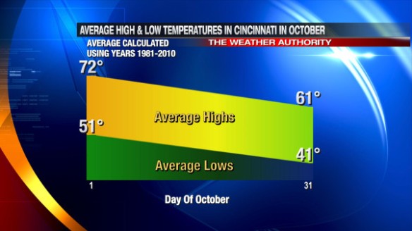
Welcome to October! Today is the first day of the second month of meteorological fall. October, like many months in the Ohio Valley, is a month of change; the most drastic change is in the temperature. While each October is different, the average high temperature drops 11° and the average low temperature drops 10° from October 1 to October 31:
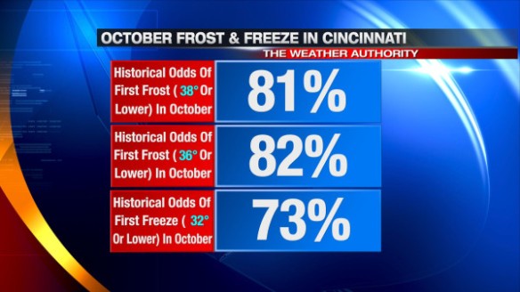
The gradual drop in temperatures – especially low temperatures – signals an increase in the likelihood of frosts and freezes. Historically (1870 to 2012), the majority of first fall frost and first fall freeze events occur in October:
In October, extreme cold is very rare in Cincinnati. The temperature has only dropped into the teens 3 times and below 30° 128 times in October since 1870. On the flip side, 90°+ heat is very rare in October. The temperature has hit 90° 6 times in October since 1870. In most years, the last 80°+ day of the year in Cincinnati is in October; the average last 80°+ day of the year is October 8th.
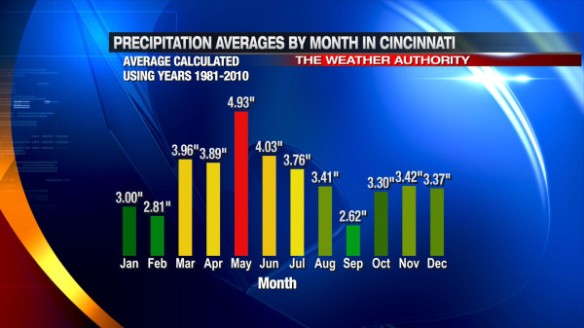
On average, October is the 4th driest month of the year in Cincinnati. September is the typically the driest month of the year, and the average monthly precipitation total increases from September to October and slightly from October to November:
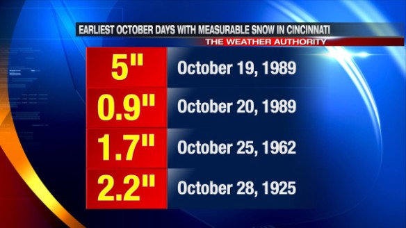
Like it or not, snow becomes a possibility in October. The earliest flurries have fallen in Cincinnati during the fall was on October 12, 1917. The earliest autumn day with measurable snow in Cincinnati was on October 19, 1989. Here are the earliest fall dates where measurable snow fell in the Queen City:
What Does October 2013 Look Like?
The latest outlook from the Climate Prediction Center released Monday suggests the Ohio Valley, Great Lakes, and New England will likely be warmer than average in October:
Released Friday, the latest run of the ECMWF Weekly model suggests each week in October will be warmer than average despite a brief blast of Canadian air diving south late in the weekend and early next week. In fact, the latest ECMWF Weekly model suggests the week of October 16th will be abnormally warm over most of the country. The newest ECMWF Weekly model also suggests precipitation amounts will be near or below average in the Tri-State this month.


