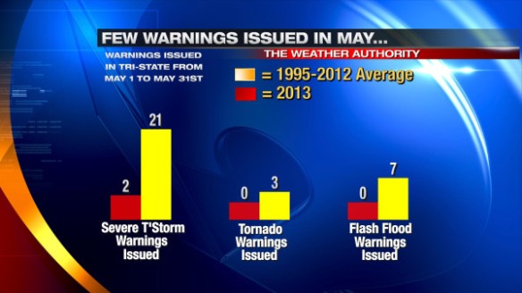
Historically, May is the second most common month for Severe Thunderstorm Warnings to be issued in The Tri-State. On average, more Tornado Warnings are issued in May than any other month, and May is the second most likely month for a Flash Flood Warning to be issued. This May, however, has been abnormally quiet for warnings. Only 2 Severe Thunderstorm Warnings were issued during the month of May in northern Kentucky, southwestern Ohio and southeastern Indiana; no Tornado or Flash Flood Warnings were issued. Here’s a summary of local warnings in May compared to average:
Only 13 Severe Thunderstorm Warnings have been issued so far this year; this is a record minimum count from January 1st through June 4th and since the National Weather Service in Wilmington began issuing warnings for the Tri-State. On average, 46 Severe Thunderstorm Warnings are issued in the first 154 days of the year.
No Tornado Warnings have been issued so far this year. For comparison, 22 Tornado Warnings had been issued through this point last year, and 32 were issued through this date in 2011. There have only three years since 1995 (2013, 2002, and 2000) where a Tornado Warning had not been issued in the Tri-State through June 4th.
Only one Flash Flood Warning has been issued so far this year in the Tri-State. 15 Flash Flood Warnings are issued through this date each year, on average.
Here’s a summary of year-to-date warning counts compared to average:
Why are warning counts so low this year? Is it the temperature? May 2013 was warmer than average (46th warmest in the last 143 years). Typically, above average temperatures in May correlate to an above average number of thunderstorm-related warnings. Spring 2013, overall, was cooler than average (51st coldest in last 143 years); cooler than average springs tend to have fewer warnings.
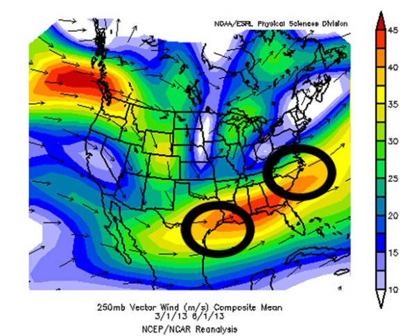
While temperatures play a part, I think the two main reasons we haven’t seen a lot of severe weather comes the lack of low-level moisture and – more importantly – from the positioning of the jet stream. From March 1st through May 31st (meteorological spring), the jet stream was mainly focused to our south:
Foci for severe weather based on the positioning of the jet stream are circled in black. Note these foci are outside of our area.
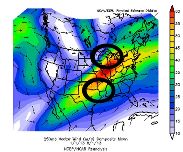
For the whole year thus far, the jet stream has been positioned more southwest-to-northeast:
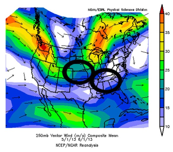
Foci for severe storms and rapid development of low pressure are circled in black. Note we are downstream of one of these foci. The jet stream was frequently dipping south into the Plains this winter; this is the main reason we are downstream of one of these foci and a reason why we had a lot of snow late in the winter. The jet stream’s positioning changed quite a bit from winter to spring. Note average position of the jet stream in just May:
…and note the favored areas for severe storms (the Plains and Mid-South, where severe storms have been frequent). After all these areas have been through, we have a lot to be thankful for this year!


Grew up in Palatine IL and had tornadoes. Moved to Cincinnati for husband to attend UC–he’s from here–and the first weekend we were here looking at apartments, there was a tornado. (He assured me that there were none here.) Therefore, I’m REALLY happy that we haven’t had warnings, etc., although I know the situation can change. Nature is amazing!
Hi, just wanted to say, I loved this blog post. It was practical. Keep on posting!