
A trace of snowfall was recorded at the Cincinnati/Northern Kentucky International Airport on Saturday. A trace of snowfall in the records means snowflakes fell from the sky, but less than 0.1″ of snowfall accumulated (if any at all).
The first snowflakes of the fall and/or winter in Cincinnati usually fall in late October or November. On the first day that snowflakes fell during the fall and/or winter in Cincinnati, only 21 of the last 100 years reported snowfall accumulation (0.1″ or more) on that day; in other words, the first snowflakes of the season usually don’t stick because the ground is too warm.
Here are the average, earliest, and latest snowfall dates with measurable snowfall and any snow in the Queen City…
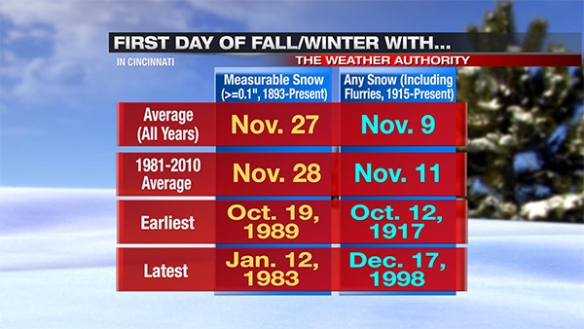
Note measurable snowfall records go back to 1893, but I have limited the “any snow” (at least a trace) record back to 1915. It is also worth noting that official snowfall records for Cincinnati have been kept in three different places since 1893:
-1893-1915: Downtown Cincinnati at the National Weather Service/Bureau office
-1915-1947: Abbe Observatory in Clifton
-1947-Present: Cincinnati/Northern Kentucky International Airport
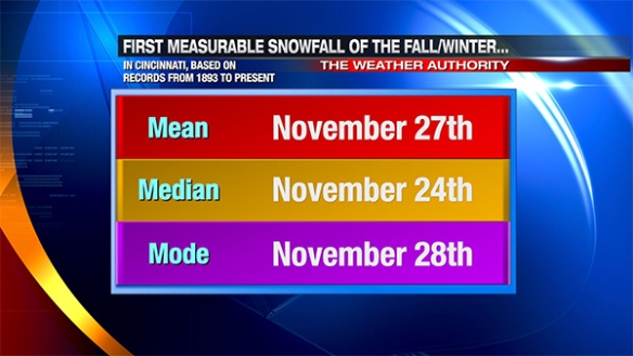
The averages and the range of dates can be helpful, but there are more than two ways to measure the first snowfall of the season. Statistically, the most common ways to measure the “center” of a set of data are involve taking the mean, median, and mode. Simply put, the “mean” is the average, the “median” is the “center” value in the chronological list, and the “mode” is the most common value occurring in the list. For example, here are the mean, median, and mode dates for the date when the first snowflakes fall during the fall/winter in Cincinnati:

Historically, the first measurable snowfall of the season comes 2 to 3 weeks after the first snowflakes of the season fall from the clouds:
The first day of the fall or winter where 1″ or more of snowfall accumulation occurs in Cincinnati is in usually not far behind the first day of the season with measurable snowfall; sometimes, they are on the same day. Here are the mean, median, and mode for the first day of the fall and/or winter in the Queen City where 1″+ of snowfall accumulates:
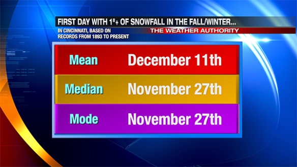
The first day of 1″+ of snowfall accumulation in Cincinnati has come as early in the fall as October 19 (1989, 5″) and as late as March 5 (2012, 1.5″, two dates after the deadliest tornado outbreak on the Tri-State on record).
Seeing accumulating snowfall earlier than average in the fall does not necessarily mean a snowier than average winter is on the way.
Overall, I believe this upcoming winter will be snowier and colder than average in Cincinnati. Compared to last winter, I believe winter 2014-2015 will be colder but not as snowy as the winter of 2013-2014.