There are various ways to measure the depth of a severe weather season. You can count the number of warnings, damage reports, or tornadoes. You can count the number of days between warnings, or you could count the number of days between the first warning of the year and the last warning of the year.
Comparing the start of the severe weather seasons to another is much easier. The date of the first warning issuance is essentially the starting gun being fired at start line of race.
Since the National Weather Service Forecast Office in Wilmington warning records began in 1995, roughly 230 Flash Flood, Tornado, and Severe Thunderstorm Warnings have been issued in the Tri-State. None of these warnings have been issued so far this year, and this is unusual.
Of Severe Thunderstorm, Flash Flood, and Tornado Warnings, a Severe Thunderstorm Warning is typically first warning of the year issued. A Severe Thunderstorm Warning has been issued ahead of the first Flash Flood Warning and first Tornado Warning 15 of the last 20 years; a Flash Flood Warning was issued first the remaining 5 years.
On average, the first Severe Thunderstorm Warning of the calendar year in the Tri-State is issued on Valentine’s Day:
Since 1995, there has not been a year in the Tri-State where at least one Severe Thunderstorm Warning was issued before April 1st. Note that severe thunderstorms can occur in January.
The first Tri-State Flash Flood Warning of the year typically comes in the start of meteorological spring:
If a Flash Flood Warning is not issued in the Tri-State before May 20th, a new record for the latest first Flash Flood Warning of the year would be set in 2015. The most common months for Flash Flood Warnings to be issued are April and May.
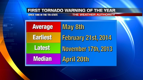
Tornado Warnings, historically, are the last of the big three warm-season warnings to be issued in the calendar year; the first one, on average, is issued in early May:
Note that it took until November 17th of 2013 to get a Tornado Warning issued. That Tornado Warning did not verify, nor did ones issued on November 18th or for Adams County before sunrise on December 22nd. For the first time since 1988, no tornadoes were confirmed in the Tri-State in 2013. The first Severe Thunderstorm Warning of that year, however, was issued on January 30th.
Colder air is in the process of returning to the Tri-State, and this cold lingering through late March and very early April may mean the slowest start to severe weather season on record based on Severe Thunderstorm Warnings. If that doesn’t convince you, making it through May without a Flash Flood Warning would make 2015 a solid contender for the top spot. If you throw 2013 out, the average first Tornado Warning of the year date drops back to April 28th, and the latest date drops to July 27th (2002).
I can’t recall a time since the year began when there was a cloud-to-ground lightning strike in the Tri-State. For storm lovers, 2015 has been a dud thus far, and they will be waiting for at least a short while to get what they want. For those who dread storms, their prayers have been answered.


