
The official high temperature in Cincinnati (at the International Airport where records are kept) today was 70°. Since official records for #Cincinnati began on December 1, 1870, there have only been 13 December days with a high temperature of or above 70°. Today was one of them.
When compared to today, there have only been 6 days in Cincinnati on record with a higher high temperature during December:
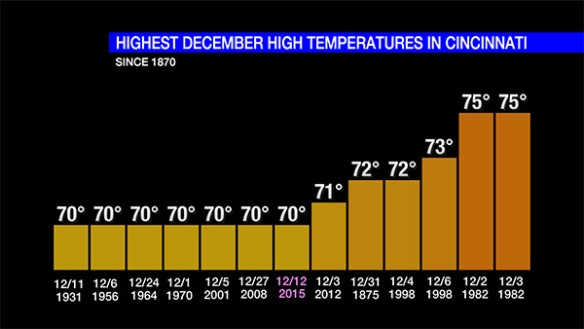
The last time Cincinnati made it to 70° during December was on December 3, 2012. There have been 7 December days in the Queen City with a high temperature of exactly 70° (most recently in 2008).
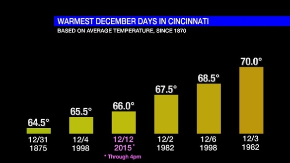
Based on the average temperature (the sum of the high and low temperatures divided by 2) through 4pm today of 66.0°, today ranks as the 4th warmest December day on record:
It is important to note that today’s average temperature is not final until midnight. Temperatures will drop near 60° near midnight Sunday, which may bring the average temperature down a degree or two.
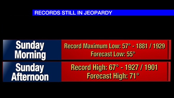
Record low and high temperatures may be broken Sunday. Low temperatures will center in the mid 50s Sunday morning, just below the record maximum low temperature for tomorrow (December 13th). Sunday’s record high temperature of 67°, however, is likely to be broken tomorrow:
The last time there were 2 or more 70°+ days in the same December in Cincinnati was in 1998 (December 4th and 6th). The last time where were 2 consecutive 70°+ days in the same December in the Queen City was in 1982 (December 2nd and 3rd).
55° is the record maximum low temperature for Monday (December 14th). While this record may appear to be broken Monday morning (with temperatures in the upper 50s and lower 60s), temperatures will fall through the 50s Monday morning and afternoon; with this forecast on the table, Monday’s maximum low temperature record is unlikely to be broken.
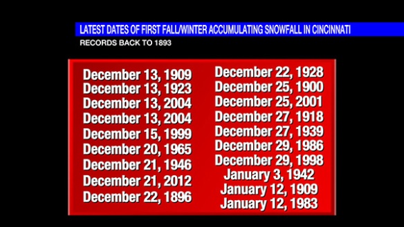
By the way, no snow fell in Cincinnati today, so the list of dates where we had to wait longer for the first accumulating snowfall of the season (historically) is growing shorter:
At this time, no snow is forecast in the next 7 days, and there is too much uncertainty in model guidance to say when our first window for accumulating snowfall will be in the next 2-3 weeks. Colder air is returning later this week, but the combination of precipitation and temperatures near or below freezing is unlikely through this coming weekend.