Just before 6pm on Monday, February 15th, I posted these words on social media: “Trolls and haters…this is your time to shine, and bring your worst.”
And they came.
There is no denying my forecasts for snow in the days leading up to the event were very different than reality. And just so we’re clear, here’s what I had forecast last night:

This is a large amount of snow for the Cincinnati area. But note that I have lower totals to the east where I felt sleet and freezing rain would be mixing in. Models become increasingly more aggressive with the presence of sleet – at the expense of snow – by midday Monday, and my forecast had changed:

By this point, sleet was falling, and I had accounted for the sleet and freezing rain rain accumulations…but I hadn’t cut snow totals significantly yet. But what was with the sudden change?
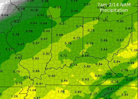
Over the last few days, it has been very clear that we would have moisture moving into the Ohio Valley on Monday. Here’s a total precipitation (all precipitation types melted down to liquid) forecast through Monday from the NAM model run early Sunday:

So we we’ll have precipitation Monday, but how much of this is going to be snow versus sleet versus freezing rain? That depends on the temperature. In meteorology, you multiply the liquid-equivalent amount by a factor to create a “snow-to-liquid” ratio. A temperature near freezing would align with a snow-to-liquid ratio of 10:1, but temperatures in the low 20s would support a ratio of 12:1-17:1. And remember, some of that liquid-equivalent could be rain, freezing rain, or sleet…or a mix of all of those. Let’s assume the 0.66″ is right and all snow, though. Here’s the snow-to-liquid ratio math for 0.66″:

If this 0.66″ is right, a forecast of 6 to 12″ is appropriate, but you want to be as specific as possible. 8-12″? 6-9″? But what if this 0.66″ isn’t right? What if it’s 0.40″ of total precipitation? Here’s the math on that:

That’s a lot less snow. If the models went from 0.66″ to 0.4″ (a drop in 0.24″) of precipitation, your snow totals are probably going to go down by at least a couple of inches. In reality, 0.2″ of liquid-equivalent fell at the Cincinnati/Northern Kentucky International Airport between 1pm and 8pm Monday! Many models – so far – are not close with this total.
Let’s revisit the temperature issue, including in the vertical. Here’s what the same model (Sunday’s 7am NAM model) is showing for the vertical temperature profile for 10am Monday morning:

This a complex graphic, but know that altitude increases moving to bottom to top in the graphic, and the red line is the temperature. The red line is left of the 32° line, and this mean the temperature is below freezing (and at least by several degrees) over a large depth of the atmosphere. This suggests we will see snow and avoid freezing rain, sleet, and rain.
Fast forward the clock to 7am Monday morning. Here’s the actual/observed temperature profile from Wilmington, Ohio:

The surface temperature is close to what is shown above, but note the temperature line (red) is closer to the freezing line (blue) compared to what is shown above. The temperature, though, is still below freezing, so snow is still the focus.
Let’s fast forward the clock to 3pm Monday. This is same model (NAM) but only looking 9 hours into the future from when the model was ran. It has a temperature near 32° just a few thousand feet above Cincinnati. This layer of air is warming.

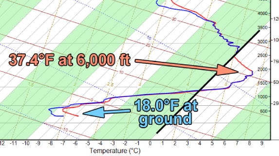
Suddenly, our forecast for snow is not looking as good. Remember, this is a modeled temperature profile. Weather balloons only get launched early in the morning and early in the evening. Monday evening’s weather balloon launch from Wilmington, Ohio shows even warmer air aloft:

Uh, oh. The temperature is a few degrees above freezing 6,000′ above the ground. This means snowflakes well above the ground are falling into this warm layer, melting, and then refreezing as they fall several thousand feet toward the ground. This is also known as sleet. Of the total precipitation that falls, more of it is falling as sleet (and less as snow) when this happens. This is a key reason many didn’t get slammed with snow. Many models were too wet with this system, and many did not capture the warm air invasion/advection aloft.
You may say: “Well, Scott, aren’t you a meteorologist? Isn’t it your responsibility to see this?” And to that I say…with what? How do I know what the temperature is at 7,000′ above the ground at every hour of the day? As I said above, weather balloons are launched twice a day in Wilmington, and the morning weather balloon was suggesting snow. How about data from an airplane? That data does exist, but it’s expensive and not publicly available. Plus…an airplane has to sample that air. So how would I know about this temperature change aloft as a forecaster? I must – in part – follow model guidance to see this. I can review guidance and compare it to reality (surface reports, satellite, radar)…but to a point. I can’t see, sample, or collect everything. And today, the things I couldn’t see….temperatures a few thousand feet above the ground and how much precipitation would fall…were not something I could understand without modeling.
The impacts of this system were good (roads were terrible, visibilities were reduced, accidents happened), but the precipitation type and amounts were off. And now you know why it’s not as easy as it looks.

Really informative and interesting post. Thanks so much for explaining and the graphics of all of the variables in weather forecasting. Really miss your posts on facebook. I have left due to their censorship, but have joined other social media platforms. Which others, like yourself, would join them as well.