I’m on vacation, so I’m going to keep this short…plus I have a lot of Christmas shopping to do!
A quick glance through the latest computer model runs shows they are more aggressive with snow chances tomorrow. As of yesterday afternoon up to 2″ of snow appeared likely north and west of Cincinnati Thursday night and Friday; models are now more aggressive with bringing snow farther south.
Here’s what the latest model runs have to say about snowfall amounts tonight in Cincinnati:
This morning’s (7am) NAM: 0.9″
Last night’s (7pm) GFS: 1.0″
Last night’s (7pm) ECMWF: 1.0″
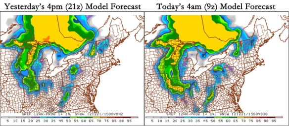
Even the SREF model probabilities for 1″+ of snow in our area have gone up. The SREF model trends are usually accurate, so this is a telling signal. Here’s a comparison of yesterday’s 4pm and this morning’s 4am SREF model runs for the potential of 1″+ of snow:
Notice higher probabilities of 1″+ of snow are higher in the Cincinnati area. With low temperatures tonight in the mid 20s and highs tomorrow only in the low 30s, this snow will be more slushy than powdery.
For now, I’m thinking storm total snowfall will look something like this…(remember, these numbers may change!):
Connersville, Liberty: 1-2″, isolated 2.5-3″ amounts
Brookville, Middletown, Lebanon, Wilmington, Hamilton, Penntown: 1-2″, isolated 2.5″ amounts
Cincinnati, Versailles, Fayetteville, Hillsboro, Alexandria, Batavia, Aurora: Around Or Just Under 1″
Vevay, Owenton, Williamstown, Falmouth, Foster, Maysville, Georgetown, West Union, Peebles: 1″ Or Less
I’ll try to get another update in later today…

