
Good afternoon! A well advertised storm system will affect the Ohio Valley over the next couple of days. Simply put, rain will transition over to snow tonight, and winds will continue strengthening over the next several hours. I have broken down this blog post into sections to focus on each threat specifically:
Precipitation
Early morning model runs are in good agreement about the strength and positioning of the low pressure (the driving force) at 7am Friday morning:
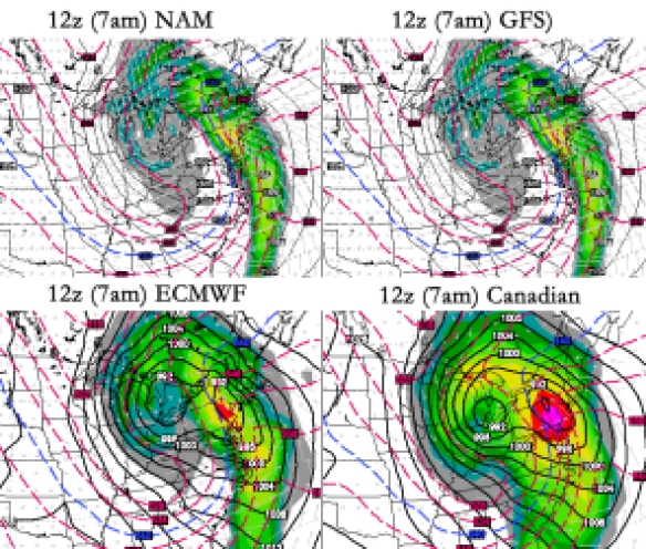
The 7am model runs all have low pressure centered over Michigan tomorrow morning. The heaviest, most intense precipitation with this system will be to our east by early tomorrow morning, but models all suggest precipitation (snow, given temperatures in the 20s) will be falling in the Ohio Valley at that time.
While rain will fall in many Tri-State locations through dinner time, rain will gradually transition over to snow approaching late evening. The latest run of the HRRR model suggests many will have a slushy inch or more of snow by 1am tonight:
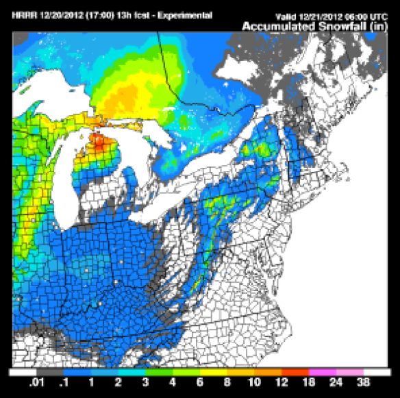
Of course, this is just one model’s forecast snowfall accumulation, but the HRRR model tends to do well with snow events like these. Notice higher snowfall accumulations north and west of Cincinnati. There will likely be some other areas north and east of Cincinnati with locally higher amounts as an upper-level disturbance moves through overnight.
Fayette, Union, Franklin, and most of Ripley County, Indiana along with Butler, Warren, Clinton and most of Highland County will likely receive 1-3″ of snow from this evening through tomorrow afternoon. Totals will be closer to 1-2″ from southern Ripley County to southern Butler County back down to northern Adams County. Less than 1″ of snow is forecast in the southern third of the Tri-State. Local 12 Meteorologist John Gumm posted this storm total accumulation graphic this morning, and his thinking is nearly identical to my thinking for now.
Snow will partially melt tomorrow as temperatures struggle to reach into the low 30s. Roads tomorrow morning in and around Cincinnati may be slick or partially covered with slushy snow. I’m cautiously optimistic road crews will keep up with snow overnight, but I’m confident there will be more accidents than usual during the Friday morning commute.
Temperatures
The chart below shows model temperatures trends in the week ahead:
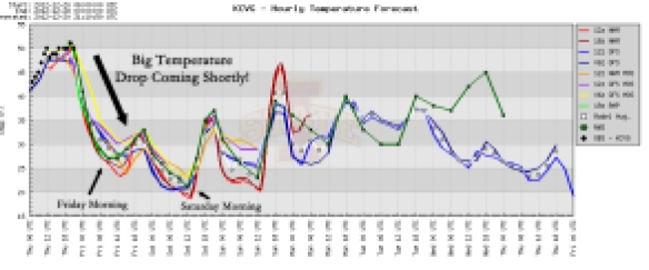
Temperatures will drop rapidly through the 40s, 30s, and 20s over the next several hours. We’ll likely be in the mid to upper 20s early tomorrow morning. The warmest Tri-State locations tomorrow will top out in the mid 30s. We’ll be back down in the 20s early Saturday morning.
Wind Chills
The chart below shows model wind chill trends in the week ahead:
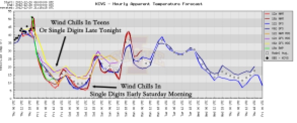
The “feels like” temperatures late tonight will likely be in the single digits and teens. It will feel just as cold early Saturday morning. Wind chills will be in the teens most of Friday morning and afternoon.
Winds
The chart below shows model wind trends in the week ahead (solid lines are sustained winds, dashed lines are wind gusts):
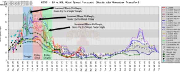
Wind chills will be well below temperatures tonight, Friday, and Friday night. Winds will gust as high as 65mph tonight and tomorrow; sustained winds will be between 20-40mph out of the southwest early this evening, then veering to the west by early Friday morning. Winds will be strong out of the northwest tomorrow.
Some will experience power outages tonight and tomorrow; light home damage also will be possible. I strongly recommend you secure any outdoor holiday decorations soon before gusty winds hit this evening; this includes any inflatable snow globes you have in your front yard!
Be safe tonight and tomorrow! Strong winds, arctic air, and accumulating snow promises to travel challenging in the next 36 hours!