
Good afternoon! The flow off of Lake Michigan has been interrupted early this morning; this means early morning clouds are giving way to sun. While today will be quite sunny, high temperatures will only be in the low to mid 30s.
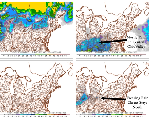
High pressure will relinquish control to low pressure Sunday. Clouds will overspread the Tri-State, and precipitation will begin developing in the afternoon. Precipitation will begin as rain Sunday afternoon and evening. The most recent SREF model run from this morning shows rain our area at 7pm Sunday night with the threat for freezing rain staying north of I-70:
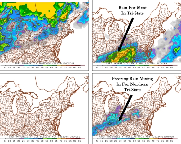
With temperatures slowly falling through the 30s, freezing rain starts to become a possibility – especially north of Cincinnati – after midnight Monday. The latest SREF model run suggests rain is more likely south of the Ohio River at 7am Monday, while many north of Cincinnati will see ice mixing with rain:
Last night’s NAM model run is not impressed with the chance for ice accumulation north of Cincinnati early Monday morning, but last night’s GFS model run is. Note the potential for about a 0.1″ of ice in the northern Tri-State through 10am Monday morning:
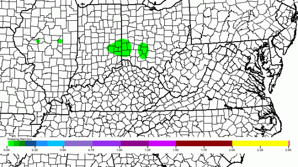
Both rain and ice will be light Sunday afternoon through early Monday. An ice storm or heavy rain is not expected at this time. Even small amounts of ice, however, can lead to very slick roads and sidewalks.
This disturbance coming through early in the week will be weak, but it will help a second, larger disturbance form and move into the Ohio Valley Tuesday, Wednesday, and Thursday.
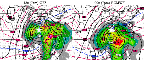
There are still some big positioning differences in the model data regarding this system. Note that this morning’s GFS model run has the center of low pressure over the Tri-State at 7am Wednesday morning, while last night’s ECMWF model run has the area of low pressure over Tennessee (Cincinnati is indicated as a white star):
Differences in the positioning of the system make a tremendous difference in what type of precipitation we will see, how heavy that precipitation we will be, and when we’ll see precipitation. A more southerly track tends to mean more snow for the Ohio Valley, but there’s more to it than that.
Last night’s GFS model run suggests more freezing rain Tuesday night and early Wednesday; a map of how much ice will accumulate according to the GFS from now through 7am Wednesday is attached:
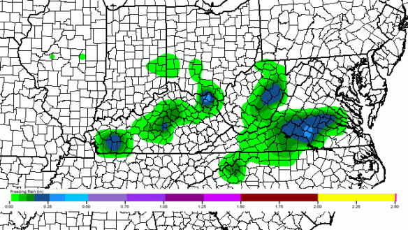
While the exact placement of ice accumulation will likely change over the next few days, it is worth noting accumulating ice will be a concern Tuesday night and Wednesday.
The most recent runs of the GFS and ECMWF models suggest accumulating snow is likely Wednesday and Thursday. Specific totals are unlikely to be released this weekend; we’ll have a better handle on amounts Monday and Tuesday.
Confidence is rising that a significant weather weather event – including snow, rain, and freezing rain – will unfold Tuesday, Wednesday, and Thursday in the Tri-State. Stay tuned!