
Computer models continue to suggest a large winter storm will soon develop in the Ohio Valley. Outside of very light drizzle or mist tonight, no precipitation is expected until Tuesday evening at the earliest. Near and after midnight Wednesday, rain and snow will overspread the Tri-State. Most northwest of Cincinnati will see all snow (or little rain) very early Wednesday morning, but the rest of the Tri-State will see a mix of snow and rain. Through Wednesday morning and afternoon, cold air will wrap in behind low pressure, and accumulating snow will overspread southwestern Ohio, northern Kentucky, and the rest of southeastern Indiana.
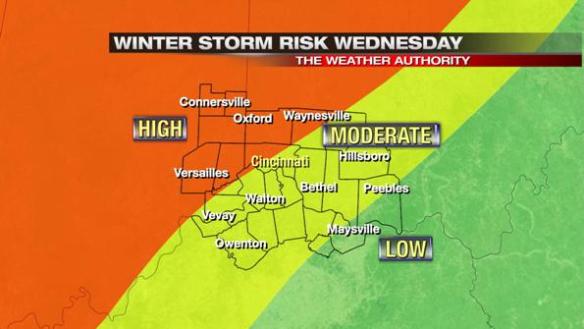
Based on recent model trends, the threat for seeing a winter storm in the Tri-State has gone up slightly:
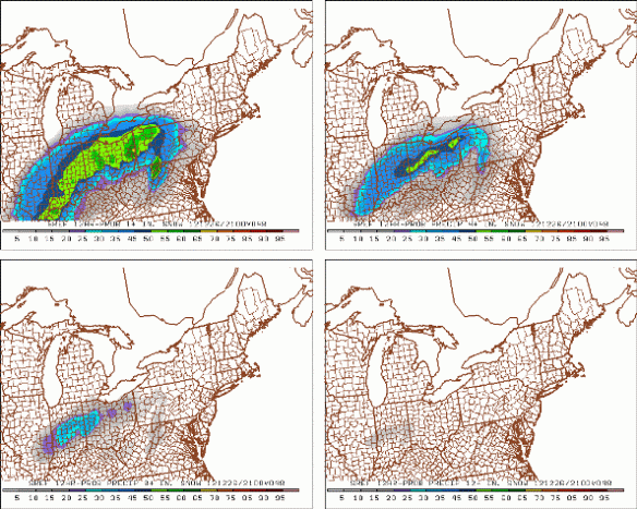
The SREF model (which is really a blend of models) suggest 1″+ is likely for much of the Tri-State between 4am and 4pm Wednesday. It also suggests significant chances for 4″+ and even 8″+ of snow in central Indiana, including the northwestern part of the Tri-State:
Just after 4pm this afternoon, the National Weather Service in Wilmington issued a Winter Storm WATCH for Fayette, Union, Franklin, Butler, and Warren County:
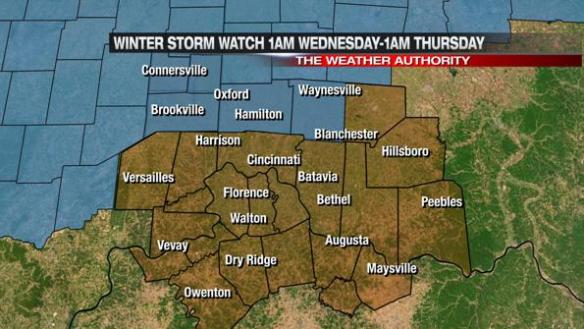
This watch is in effect from 1am Wednesday to 1am Thursday. This watch may be expanded or Winter Storm Warnings and/or Winter Weather Advisories may be issued in the next 24 hours. Travel will be difficult at times Wednesday, especially during the afternoon and evening.
There is still great uncertainty on the exact timing, strength, and positioning of this system. The forecast will likely change as new model data comes in and once the storm forms.
There will likely be a WIDE spread in totals from Connersville to Maysville. Some models have a spread of over 12″ of snow between these two cities. This will be an abnormally difficult forecast, and it will be very difficult to pin down snowfall amounts for any given location especially with blowing snow.
Thank you for your patience while we continue to make an accurate forecast. Stay tuned…