
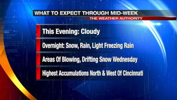
A large winter storm is on the way to the Ohio Valley later tonight and tomorrow. Like many storms in the Ohio Valley (especially where rain and ice mix in), snowfall totals are going to be tricky. There is fairly high confidence that the heaviest snowfall totals are going to be focused north and west of Cincinnati. Lower totals (where light freezing rain and rain will be found much of tonight and tomorrow) will be along and south of I-71. There is still great uncertainty in snowfall amounts along I-71. Some counties may see a 3-6″ spread from the highest snowfall total to the lowest total in the county.
A Blizzard WARNING is in effect from 1am tonight through 1am Thursday for Fayette, Union, Franklin, Butler, and Ripley County. Many in this area can expect frequent gusts up to 35-40mph, blowing and drifting snow, and visibilities under 1/4 due to blowing and drifting snow late tonight and Wednesday:
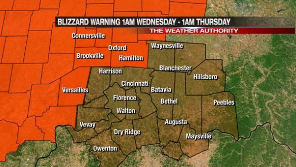
A Blizzard Warning does not mean 2′ of snow; it is issued when a combination of winds and low visibility make it difficult to travel. I strong discourage travel in this warned area late tonight and tomorrow. Sustained blizzard or blizzard-like conditions are not expected at this time in the Cincinnati metro.
A Winter Storm WARNING is in effect from 1am tonight through 1am Thursday for Warren and Clinton County. These areas are likely to see gusty winds, bursts of heavy snow, and wind chills in the mid teens to lower 20s overnight and tomorrow. 4-6″ of snowfall accumulation (with isolated higher amounts) are forecast in the northern half of the warned area:
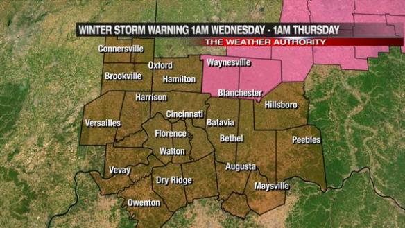
Lower snow amounts are forecast closer to the Ohio River, where a Winter Weather Advisory is in effect from 1am tonight through 1am Thursday:
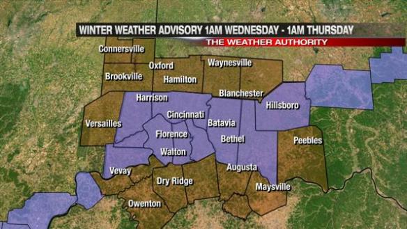
Notice there are areas south of this advisory not under any sort of alert. Only 1″ or less of snow is forecast in these areas, mainly due to the amount of freezing rain and rain mixing with snow. In fact, sections of northern Kentucky may see rain for most of the night and Wednesday before changing over to snow.
The most severe winter weather will be northwest of Cincinnati tonight through tomorrow night. Less snow and lighter winds will be found along and south of I-71, especially from Owenton to West Union.
For now, here is what I expect for snowfall amounts:
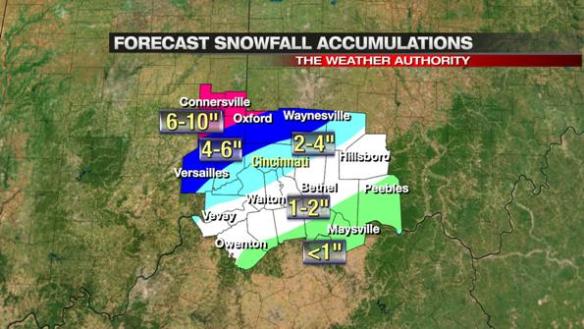
Notice the differences in snow totals, especially in counties along I-71. If this forecast verifies, northwestern Hamilton County will see 4-6″ (with isolated higher amounts) and southeastern Hamilton County will see 1-2″. These forecast snowfall amounts may change later tonight and tomorrow, and there may be isolated higher or lower amounts outside of each snow band.
Do you need any outline of when things are going to happen? There’s a lot to take in; I understand! Expect snow northwest of Cincinnati, rain and freezing rain southeast of Cincinnati, and a mix of rain, snow, and freezing rain along I-71 and in Cincinnati to change over to mostly snow by late tomorrow afternoon. Even at 4pm tomorrow, there will still be many with little or no snow accumulation (and just rain and/or flurries) well southeast of downtown:
Stay tuned; we will update the forecast as needed!
Greeat blog you have here