
The weekend is coming to an end, and so is a rather warm and soggy pattern. Cincinnati hit 66° before 3am this morning, and temperatures will crash into the 20s overnight in the wake of a strong cold front.
Compared to most of this weekend, the week ahead looks much colder, but still reasonably close to average (average low today: 23°, average high today: 38°).
There are a couple of cold punches to track in the next two weeks.
Arctic Air Coming Later This Week
The latest run of the GFS model (from this morning) is very aggressive arctic air later this week, bringing it into the Great Lakes and southeastern Canada by Thursday morning (as shown in purple, red, and yellow):
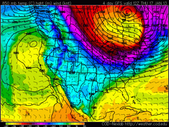
This morning’s GFS model was not this aggressive with the cold air compared to last night’s or yesterday morning’s run, so I am skeptical of how aggressive the newest run is with arctic air.
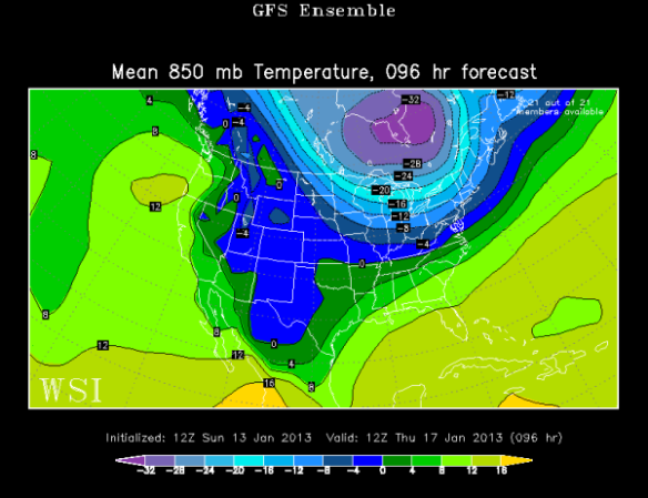
With that being said, there is support for this arctic blast from the GFS model runs that are used to create the main GFS model run; meteorologists call these “mini” model runs ensembles. Ensembles are a series of models with the initial conditions changed slightly; if model runs with different initial conditions all point towards a specific solution in time, the odds that a certain type of weather will happen increases. Ensemble forecasting is based off of the idea that computer models often don’t have time (or access to computing power) to ingest every little weather detail for the entire world. Computers often make approximations to save time; ensembles allow us to see how differences in initial conditions make a difference in the forecast. Taking an average or mean of all of the ensembles is a convenient way to see what the ensembles think – overall – in one simple graphic.
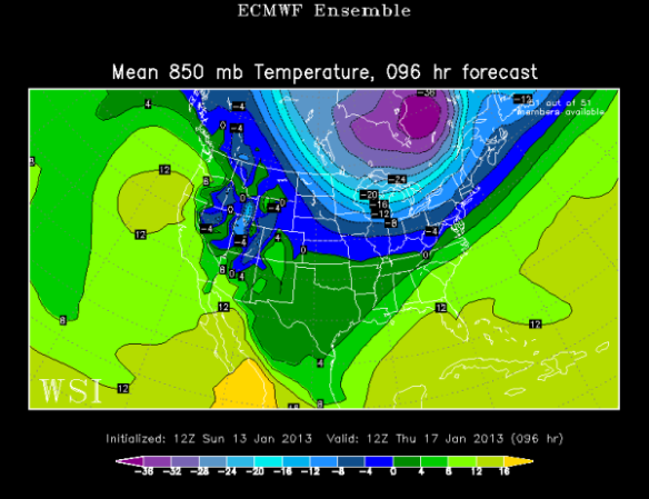
This morning’s GFS ensemble mean also has this arctic air over southeast Canada and the Great Lakes Thursday morning, but the core of arctic air (shown in light blue and purple) isn’t quite as strong and isn’t as far south:
The European model’s ensembles also have this cold punch to our north by Thursday morning, but is even less aggressive with the arctic air into the northern United States:
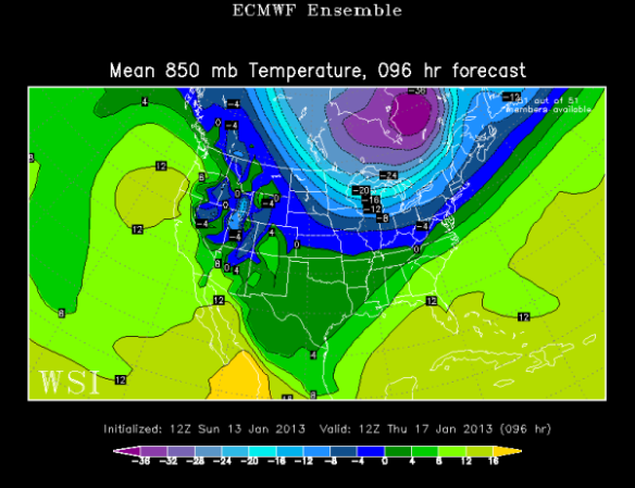
Clearly, there is some uncertainty on the positioning and strength of the cold air coming later this week. Despite some differences, there is fairly high confidence that this arctic air will put a stop to subtle warming trend forecast Monday through Wednesday.
Arctic Air Coming Next Week
As mentioned above, this morning’s GFS model is very aggressive with pushing arctic air south later this week…and also next week. The GFS suggests this piece of arctic air will be diving south sometime between Monday and Wednesday of next week. Here’s where this morning’s GFS model run puts it (shown in purple, red, and yellow) by Wednesday morning:
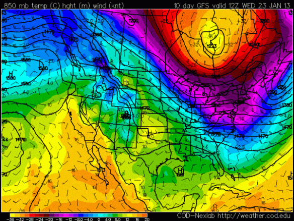
Again, this is a long range forecast and the GFS has just recently gotten aggressive with cold air. For a second opinion, here’s what the GFS ensemble mean suggests for arctic air (shown in light blue and purple) next Wednesday morning:
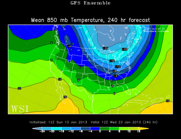
The GFS ensemble mean is farther west and not as cold as the GFS. The European ensemble mean is colder than the GFS in Canada but does not have the arctic air as far south:
Just like with the forecast later this week, there is a lot to get worked out regarding next week’s potential arctic blast.
For now, I’m thinking we’ll have have highs in the mid to upper 30s Thursday and in the 30s Monday through Wednesday next week. We will likely be on the fringe of both these arctic air masses. This arctic air is here to remind us that winter is not over!