
The temperature has been nearly steady all morning and afternoon in Cincinnati, but the temperature will be fluctuating quite a bit in the next 10 days as the jet stream moves south and retreats back to the north.
For now, the jet stream is to our north; it will likely stay to our north through tomorrow. The latest GFS model has abnormally warm temperatures (in the orange and red colors) in the Ohio Valley at 1pm tomorrow afternoon:

On Wednesday, however, the latest ECMWF model suggests the jet stream will dip to the south, bringing slightly cooler air to the region:

This dip in the jet stream will temporary; the jet stream will push back to the north by Thursday. The latest GFS model shows above average temperatures (in orange and red) surging north into the Tri-State with the jet stream retreating back into southern Canada:

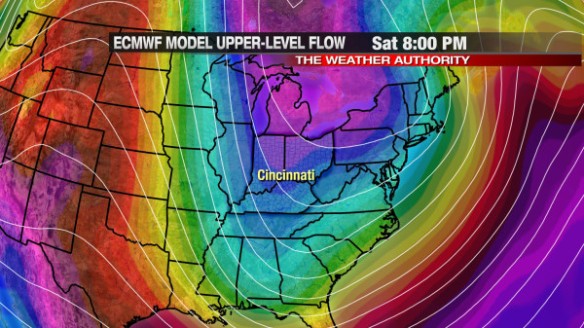
This change in the jet stream, too, will be temporary; the jet stream will once again push south this weekend, as the latest ECMWF model shows by Saturday night:
This morning’s GFS model shows abnormally cold air (shown in blue, green, white, and purple) aloft by 7pm Saturday night:
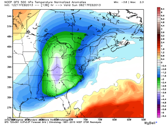
This cold air aloft will likely support a chance for flurries Saturday, Saturday night, and early Sunday.
While the weekend will be chilly, near or above average high temperatures will likely return by Tuesday. The latest GFS model has above average warmth in the Tri-State early Tuesday morning:

Winter is not over! This up-and-down pattern will likely continue for the rest of February and into early March…