With flurries and clouds moving out into early evening and high pressure nearby tomorrow, our main forecast concern in the week ahead is with a late week system. A potpourri of precipitation types (snow, rain, sleet, and freezing rain) are forecast in the Ohio Valley Thursday night.
This will be a tricky forecast, especially with a lack of consensus among models. With a lack of consensus, it is not worthwhile to make a specific county-by-county ice accumulation forecast. We are also more than 48 hours out on this event, supporting the idea that now is not the time to go into specifics.
My focus for this blog post will be on output from the SPC Short Range Ensemble Forecast (SREF) model. The word “ensemble” in meteorology refers to a series of models that are run with different initial conditions; if models with different initial conditions are in good consensus on a particular forecast, confidence is higher than average that particular forecast will verify. Looking at the mean of the SREF models helps to weed out extreme model forecasts.
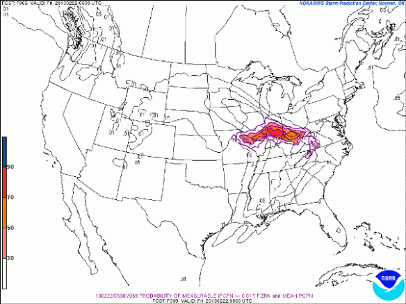
This morning’s SPC SREF run gives the Tri-State between a 30% and 90% chance (depending on where you live) of measurable ice accumulation between 10pm Thursday and 1am Friday:
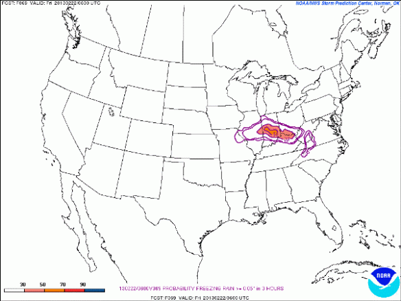
This morning’s SPC SREF gives the Tri-State a roughly 40% chance that we get at least 0.05″ of freezing rain accumulation (at least a light glaze) between 10pm Thursday and 1am Friday:
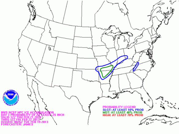
NOAA’s Hydrometeorological Prediction Center gives most of the Tri-State a 10% chance of 1/4″ of ice accumulation or more Thursday night and early Friday:
1/4″ of ice accumulation serves as a rough milestone for where power lines start to sag or may fall completely to the ground. 1/8″ of ice will lead to some slick roads and sidewalks
This morning’s GFS model gives Cincinnati about 0.2″ and Wilmington about 0.15″ of ice accumulation Thursday night; likewise, this morning’s NAM model gives Cincinnati about 0.15″ and Wilmington about 0.1″ of ice accumulation Thursday night. Again, these are what two models are projecting and is NOT a forecast. I share these totals with you to show that this is not going to be a major ice event but may be more than a nuisance.
What To Expect Thursday Night
Confidence is high that sleet, rain, snow, and freezing rain will overspread the Ohio Valley Thursday evening. Precipitation will likely start as a mix of rain, snow, and freezing rain in Cincinnati with temperatures around freezing. Nearing 12am Friday, the mix of snow, rain, and freezing rain will transition to a rain and freezing rain mix…with a small chance for sleet also. By sunrise on Friday, most – if not all – of the Tri-State will see rain with some freezing rain and sleet mixing in north of Cincinnati.
Right now, I’m thinking some in the Tri-State see a light glaze of ice, especially north of the Ohio River. Temperatures will be in the lower 30s nearing all of Thursday evening; the temperature is forecast rise 1-3° between 10pm Thursday and 7am Friday, which works against the idea of ice accumulation.
A 1-2° change in temperatures Thursday night may have a significant impact on what type of precipitation you see and how much ice you see. It is better to start conservative on an ice forecast and ramp up if needed than to go the other way.
Stay tuned for an update tomorrow!


