
There are several things about this weekend’s weather setup that are troubling. First, waves of heavy rain are forecast this weekend, this after a couple days of snow melting to saturate the ground. Second, there is a threat for strong and severe storms this weekend in the Ohio Valley; after a quiet spring and summer, this fall and now winter has been very stormy. Severe weather events in the Tri-State during the month of December are very rare.
Several disturbances will affect the Ohio Valley Friday through Sunday; the thinking on the strength and timing of each has not really changed in the last 24 hours.
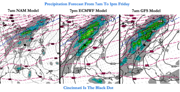
The latest computer forecast model runs all have widespread light to moderate rain in the Tri-State Friday morning and afternoon:
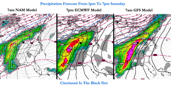
This initial round of rain is not going to cause widespread problems, but it will help to saturate the ground. Models have widespread moderate to heavy rain moving in Saturday afternoon and evening:
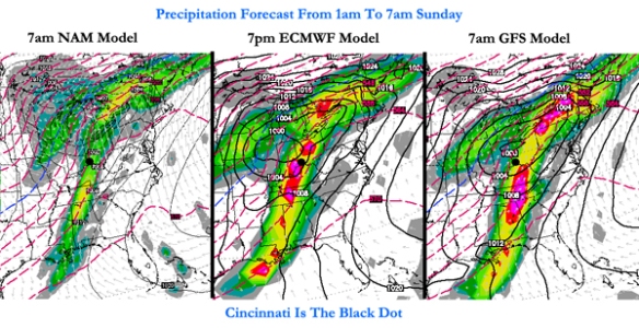
Moderate to heavy rain continues into early Sunday with the center of low pressure to the northwest of Cincinnati:
Given the dewpoints in the 50s and 60s, temperatures in the 50s and 60s, the positioning of the jet stream, and modest instability, thunderstorms are forecast from Saturday afternoon through Sunday. In addition to the threat of thunderstorms, there is also support for strong and severe storms in the Tri-State Saturday night and early Sunday. Being south of the warm front and east of the cold front puts us in the “warm sector,” or the warm, moisture-rich airmass that will support storms. Specifically, there is a concern for damaging straight-line winds early Sunday morning.
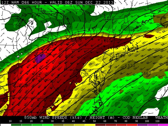
The latest NAM model run has 60-100+ mph winds 5,000 feet above the Ohio Valley at 1am Sunday:
This morning’s GFS model run has the strongest winds positioned differently but just as strong early Sunday morning:
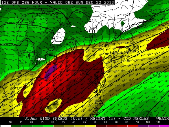
This fast moving zone of winds just above the ground is called the low-level jet. It typically strengthens before and during severe weather events, but these speeds are abnormally strong for late December. Mathematically speaking, these wind speeds are 3-5 standard deviations above average for this time of the year. Simply put, these wind speeds are rare to very rare for December. Winds 5,000 feet above the ground are often transferred to the ground – in part or whole – when heavy rain is falling. With moderate to heavy rain forecast as these winds are coming through, there is a concern for severe winds Saturday night and early Sunday morning.
While instability can often have a big influence on the chance for thunderstorms, it isn’t as important this time of the year. If thunderstorms are likely (which they are Saturday night and Sunday), the SHERB parameter or index can be very helpful to a meteorologist in the colder months when looking a threat for severe weather. The SHERB parameter is helpful for getting a handle on a severe weather threat in the colder months because it focuses on temperature changes near the ground, lift in the atmosphere, and wind shear instead of instability (instability tends to be low in the winter even when we get severe weather).
Why is SHERB important? Unlike summer severe weather events which are driven by high instability and less of everything else, cold season events are driven by everything else and not often by instability. SHERB is a special blend of “everything else” that is important when gauging a severe weather threat…which makes it valuable when we don’t have summer-like heat and humidity. When SHERB values are high and the chance for rain and storms is high, severe weather is often a concern.
SHREB values on Saturday night and early Sunday morning are elevated in the Ohio Valley. This morning’s NAM model has SHREB values that are high (yellow) and support a Tri-State severe weather threat (Cincinnati is the black dot):
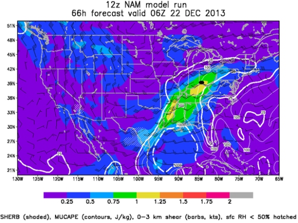
SHERB tells us that instability isn’t really necessarily to get rough storms Saturday night and early Sunday. Any instability will only aggravate the atmosphere more than it is already primed.
Plus, there is a threat for heavy rain and flooding this weekend. The Weather Prediction Center has already placed the Tri-State in a MODERATE risk for excessive rainfall from 7am Saturday to 7am Sunday:
A Flood WATCH is likely coming for most if not all of the Tri-State later today. It will likely be in effect most if not all of Saturday and Sunday.
Here is how much rainfall various models are forecasting from 7am Friday to 7am Monday:
NAM 1.72″
ECMWF: 1.94″
GFS 5.40″
The GFS is clearly overdone, but 1-3″+ of rainfall is likely Friday, Saturday, and Sunday.
Be prepared for flooding and storms this weekend!
Is it Shreb or Sherb? Thanks in advance
Harvey…it’s SHERB.