
Yesterday afternoon, models suggested 1-2″ of snow would accumulate in the Tri-State tonight through Saturday afternoon. The newest model data is more aggressive with the chance for snow, so forecast snow amounts have gone up.
Recent SREF model runs have shifted heavier snowfall amounts north overnight, and have also increased totals. The risk for 1″+ of snow from 10pm to 10pm tonight is on the left; the 4″+ chance is on the right:
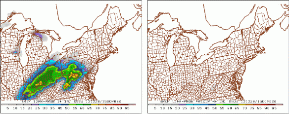
Notice a rather high chance for 1″+ in and around Cincinnati in this time period, but a low chance for 4″+. This is the main reason why I am not including 4″+ totals in my forecast for now. An isolated 3.5″ to 4″ amount is possible in our area, but it is not likely at this point.
The latest high-resolution ECMWF model shows generally 2-3″ of snow in the greater Cincinnati area tonight through tomorrow night:
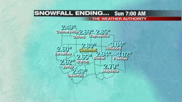
These totals look realistic with the exception of the far southern Tri-State, where most models have lower snow amounts.
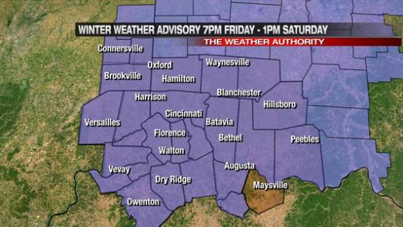
The National Weather Service has issued a Winter Weather Advisory for all but Mason County, Kentucky from 7pm tonight through 1pm tomorrow:
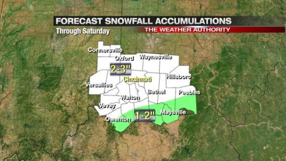
My latest snow forecast calls for 2-3″ for most in the Tri-State tonight through tomorrow afternoon; 1-2″ totals will be confined to parts of Owen, Mason, Robertson, Grant, Bracken, Adams, Brown, and Pendleton County:
Forecast totals will likely change later today; look for updates this afternoon and evening!