
The Storm Prediction Center has placed the Tri-State in a risk for severe storms on Tuesday, highlighted here:
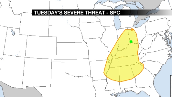
For this and all graphics below, Cincinnati is labeled with a green dot. What type of risk is this? Think of it as a “slight” risk for now. A formal classification of “marginal,” “slight,” “enhanced,” “moderate,” or “high” is only used for a given day and the two days that follow it, so we will get the category tomorrow.
What is contributing to this risk? First, strong or severe storms need access to instability. Warm, moist air at the ground and cold, dry air aloft will help air to rise and create storms. Here’s what Saturday morning’s NAM model thinks for instability at 4pm Tuesday:
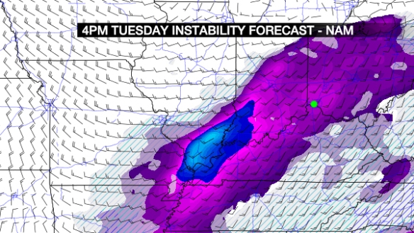
Modest amounts are in the purple, and higher amounts are in the blue. Even the purple shades can support storms, but other ingredients need to be in place (especially in the colder months of the year) to get thunderstorms.
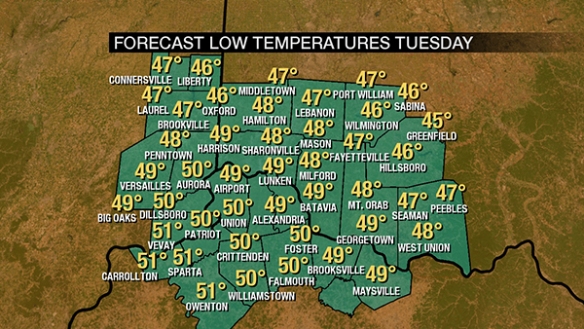
Will it be warm? That’s important. I see temperatures only dropping to near 50° early Tuesday…
…and rising into the 60s Tuesday afternoon:
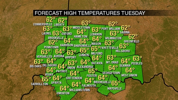
That’s more than warmth enough to see thunderstorms, including strong and severe storms.
How about moisture? Here’s the dewpoint forecast for the next few days:
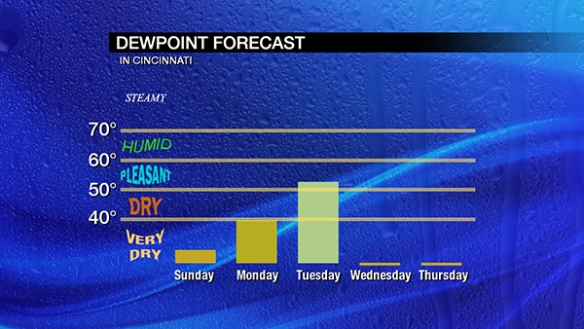
We don’t need to be humid this time of the year to get strong or severe storms, but the dewpoint almost always needs to be above 50° to get severe storms in February.
How about lifting mechanisms for the assist? The NAM model (like others) has several compact disturbances (orange/red colors) over the Ohio Valley Tuesday afternoon:
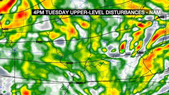
…this supports storms, but it’s not impressive lift. How about the jet stream? Here’s what the NAM thinks at 4pm Tuesday:
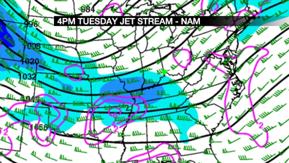
Jet stream level wind speeds are in blue, and upper-level divergence of air (promoting lift) are in contours of pruple. There is also lift in the “left-exit” region of the jet streak (part of the jet stream) over the Tri-State. This lift overhead will support storms, but it’s not big time lift.
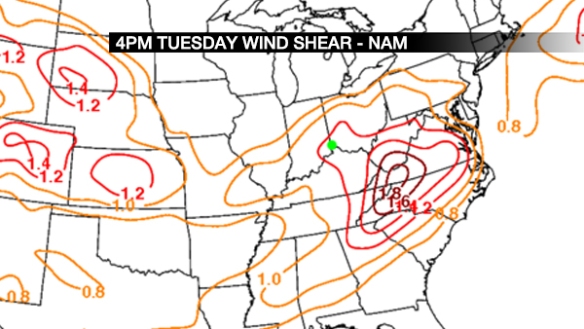
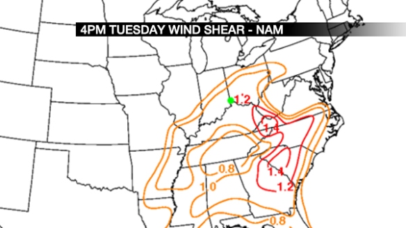
How about wind shear (the change of the wind speed or direction with increasing altitude)? The NAM has plenty of that:
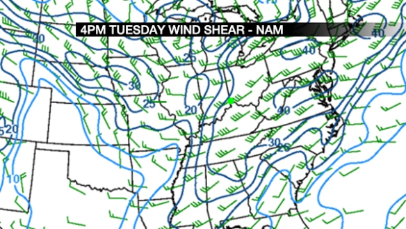
Remember this is SPEED shear shown here, not directional shear (a lot of the latter supports tornadoes).
How about helicity (a measure of how likely storms are to rotate)? The NAM has us in a 200 m2/s2 area:
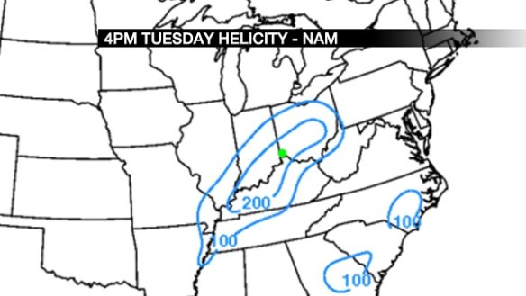
What the heck does that number mean? The threshold for what supports severe storms can vary from one season to the other, but this is significant to mention a tornado risk somewhere in the Ohio Valley. Let’s not discuss the level of this risk for now, but instead, acknowledge that this threat should be watched.
How about the SHERB parameter? What’s that? See more on this in this blog post from 2015. This is a helpful parameter in severe weather setups when instability is low. Now that that’s been explained, here’s what the NAM thinks for SHERB at 4pm Tuesday:
Any value over 1 with thunderstorms in the area suggests those storms may be strong or severe. How about effective SHERB (in simple terms, SHERB but accounting for storm depth) at 4pm Tuesday?
Again, values are near or just above 1, which supports a strong to severe storm threat.
So what do I think about Tuesday’s severe storm threat? Here’s my latest thinking based on the setup and acknowledging uncertainty:
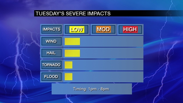
Stay tuned. This threat may change, and new guidance will help to target areas that have a better threat versus other areas.