
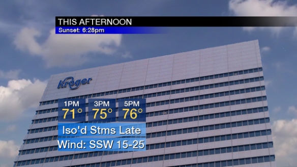
Temperatures will soar into the mid 70s this afternoon with more sun than clouds. Today’s record high temperature is 72°, set in 1930. The all-time record high temperature in Cincinnati for February is 76°, set on February 10, 1932.
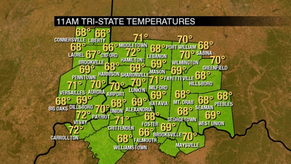
As of 11am, temperatures are already in the upper 60s and lower 70s:
For February standards, the dewpoint is very high at 55° as of 11am:
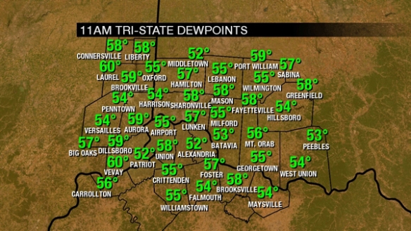
For perspective, the average February dewpoint in Cincinnati is 24°, and the record highest dewpoint in Cincinnati.
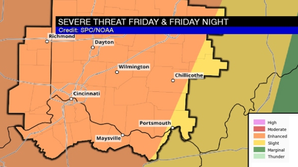
As of 11:30am, the entire Tri-State is in an ENHANCED risk for severe thunderstorms through tonight:
This threat will be maximized this evening. More sun than clouds will lead to temperatures rising into the 70s as instability grows:
Plan for a mix of sun and clouds this afternoon before isolated showers and storms begin developing between 4pm and 6pm. Wind speeds will increase this afternoon (sustained between 15 and 25mph by 5pm):
Rain and storms will increase in coverage and intensity this evening as a cold front nears:
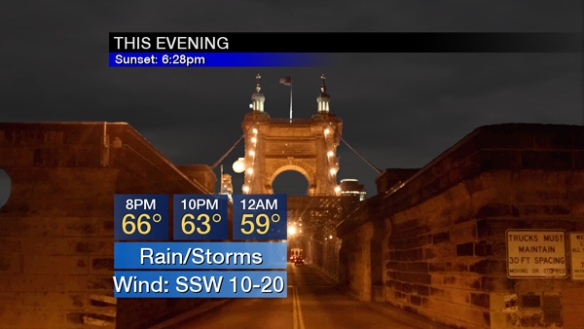
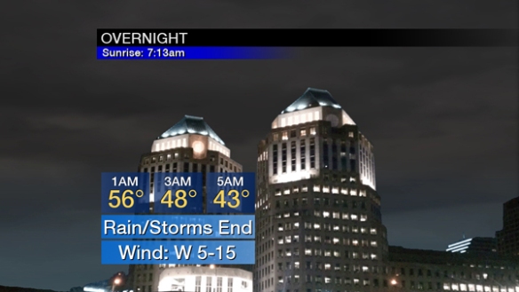
Rain and storms will push east of the Tri-State between 12am and 3am. Notice temperatures will fall through the 60s and 50s this evening and then through the 50s, 40s, and into the 30s late tonight:
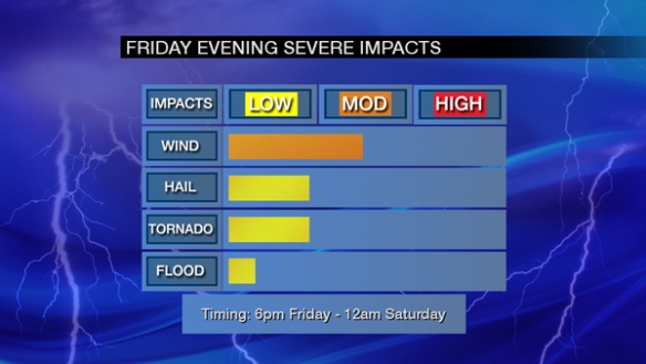
Over the last few days, I’ve been posting a impact graphic for Friday’s severe threat. Now that it’s Friday, I’ll break the threats down by period, starting with late this afternoon:
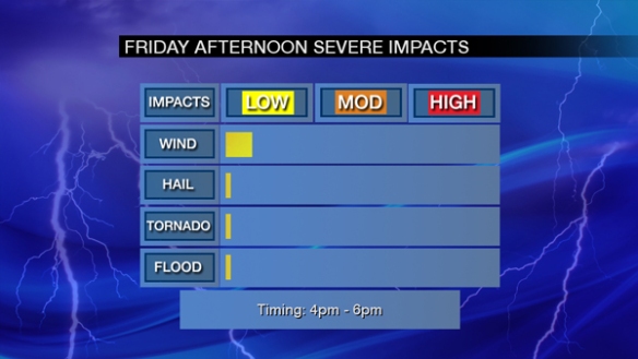
This is a minimal severe weather impact, but this evening’s severe threat will be much higher with damaging straight-line wind being the main concern (and tornado and large hail being secondary threats):
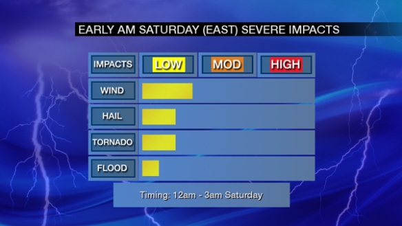
The threat for severe storms will end and be focused east of Cincinnati in the early overnight:
Since 1995 (when the National Weather Service in Wilmington opened), the record for the greatest number of warnings in the Tri-State during a single February is 12 (set in 2002). There are an average of 3 Severe Thunderstorm Warnings issued in the Tri-State each February.
So what might the radar look like? Guidance is still messy, so I encourage you to follow the overall trend in these graphics. Here is what high-resolution guidance suggests the radar might look like at 4pm today:
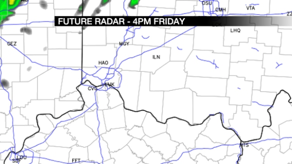
Basically, storms are starting to develop along/north/west of I-71, but the coverage is limited. The main event comes this evening. Let’s fast forward to 7pm:
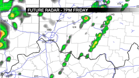
Storms are increasing in intensity and coverage. Other guidance suggests two lines of storms forming near and west of the Tri-State. Let’s go to 10pm:
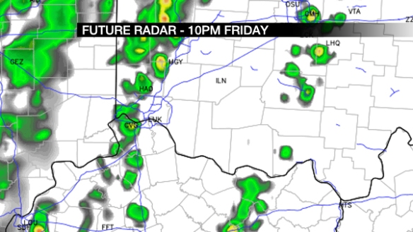
Lines of showers and storms are sweeping into and through the Tri-State late in the evening. Some storms may be strong or severe at this time. Let’s fast forward to 1am Saturday:
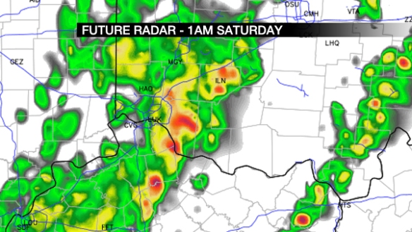
Rain and storms are moving through southwestern Ohio and northern Kentucky. Strong and severe storms are still a possibility at this time, but the overall threat is diminishing.
Have a way to get watch and warning information today and tonight. Do not think because the sun sets tonight that the threat for severe weather is dropping.