There have have been a lot of questions surfacing recently about whether the lack of heat this summer means the winter of 2013-2014 will be colder or snowier than average. I was at a speaking engagement last last week, and one of the few questions that came up was about what the fall and winter forecast.
Global patterns change frequently throughout the year. Many of the oscillations that occur in the atmosphere (that help to drive major weather systems) usually complete an oscillation on the scale of days, weeks, or months. As a result, it is very difficult to look at one season and use it to forecast another. Climatologists and meteorologists often make seasonal forecasts based on analogs, or years that have a similar setup to a certain pattern; however, there is rarely – if ever – a perfect match.
If summer 2013 had ended at midnight (on August 20th), summer 2013 (beginning June 1st) would only be the 35th coldest on record in Cincinnati. Weather records for Cincinnati go back to November 1, 1870, so it’s tough to have a “top 10” or “top 20” year for snow, rain, cold, or heat. When you compile a list of the coldest summers on record in Cincinnati and look at the temperature departure from average in the winter (December 1st to January 31) that followed, here’s what you’ll find:
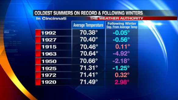
The numbers in blue highlight a slightly cooler than average winter, the purple numbers show a much cooler than average winter, the tan numbers spotlight a slightly warmer than average winter, and the pink numbers highlight a much warmer than average winter.
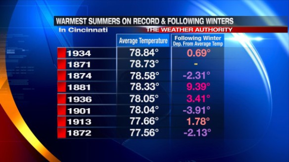
Many of the winters following the coldest summers on record were colder than average, but that wasn’t always the case. You’ll notice the same “sometimes but not always” thinking applies to the winters following the warmest summers on record in Cincinnati:
Does a colder than average summer mean we’ll mean a snowier than average winter is coming? Not necessarily. Here all the coldest summers on average and the snowfall departure from average in the winter that followed:
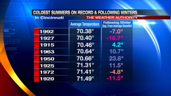
The numbers in blue show a slightly snowier than average winter, the purple numbers spotlight a much snowier than average winter, the tan numbers highlight less snow than average in the winter, and the pink numbers shows 10″+ of snow below average in the winter.
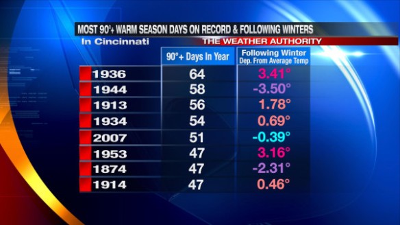
Does a lack of 90°+ days in the spring, summer, and fall mean the winter to come will be colder than average? Here’s the table of the fewest 90°+ days in the spring, summer, and fall plus the departure from average on the winter that followed:
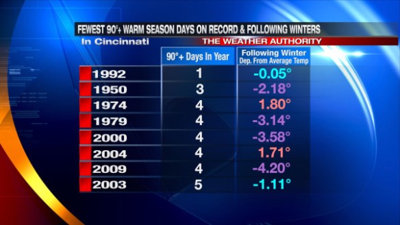
Sometimes the winter was warmer than average; sometimes it wasn’t. The same thinking applies to the list of the most 90°+ days in the spring, summer, and fall in Cincinnati:
My Thoughts
It is way too early to be speculating about the upcoming winter forecast. We will begin to look at the winter forecast in September and fine tune our thinking in October and November. One or two weeks of abnormally cold or warm temperatures can affect the seasonal average. One or two big weather systems can affect the seasonal snowfall total in a big way. Even the exact orientation of lake-enhanced and lake-effect snow bands can affect temperatures and snowfall amounts. With high temperatures forecast to be in the 80s and 90s through next weekend, a winter forecast is not something I want to tackle yet.
I have found little to no correlation between summer heat and winter cold/precipitation. Summer 2012 was the 18th warmest summer on record in Cincinnati; the winter that followed was warmer but snowier than average. I remember saying last November that the winter of 2012-2013 would be near average for both temperatures and precipitation amounts, but my thinking was a lot different when when our first frost and freeze came earlier than usual in late September and early October.
When rumors of big snowstorm come each year, people are hoping for pinpoint totals several days out, when – in reality – it is best to issue a forecast when the confidence is higher and forecast models are more reliable. I will not speculate on the winter forecast until I have a good handle on what is going to happen. When a chill in the air returns, a discussion on the winter forecast will surface. Until then, enjoy what’s left of a rather calm, cool, and not too humid summer.