Where Will The Upper-Level Low Go?

In the world of meteorology, we spend a lot of time focusing on what is going on near the ground. What goes on above the ground, however, can be just as important if not more important than what is going on near the ground. It is not uncommon for there to be differences in model data near the ground, but upper-level differences are less common. Large upper-level differences often mean big problems when getting a forecast together.

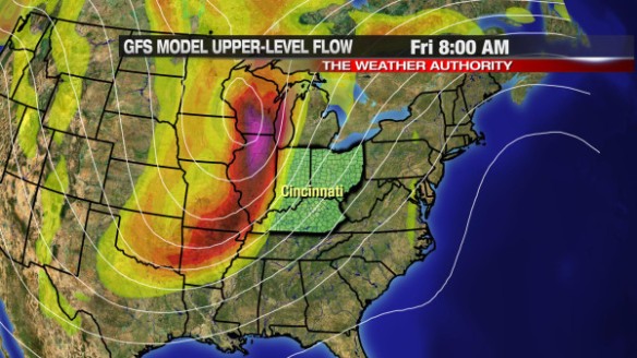
A prime example of how upper-level differences affect the forecast comes later this week and early next week. Meteorologists often look about 18,000 feet above the ground for disturbances and areas of low pressure; later this week, we find little consensus on where a developing area of low pressure will go in the week ahead.

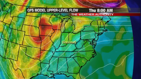
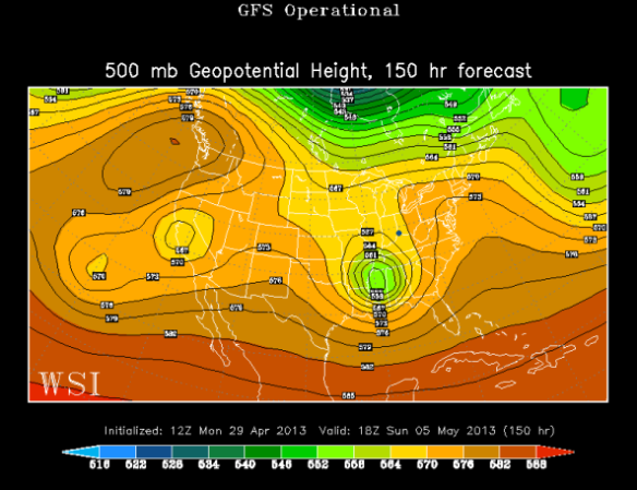
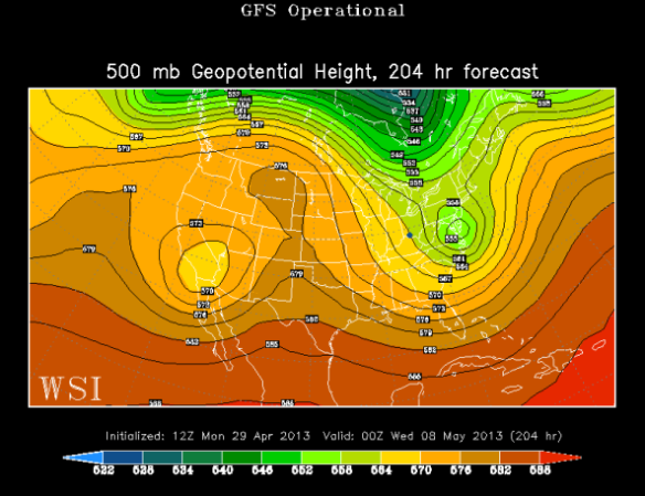
This morning’s GFS model run suggests this developing area of low pressure will be centered over southeast Arkansas Sunday afternoon (Cincinnati is labeled with a dot, and the area of low pressure is in green to our south):

apr29-12zgfs18zsunday

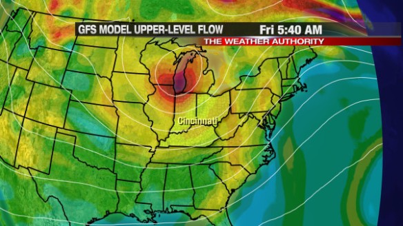
Last night’s GFS model run, however, says that same area of low pressure will be over the Mississippi Valley Sunday afternoon:

apr29-00zgfs18zsunday

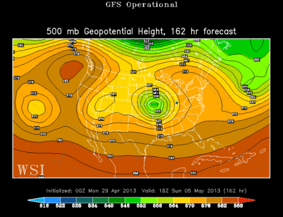
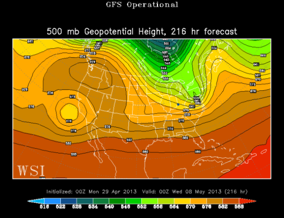
Upper-level low uncertainties continue into early next week. This morning’s GFS model suggests this upper-level low will be to our east by next Tuesday evening:

apr29-12zgfs00zwednesday

Last night’s GFS model also has this model to our east by next Tuesday evening, but it is much weaker (which could affect rain chances):

apr29-00zgfs00zwednesday

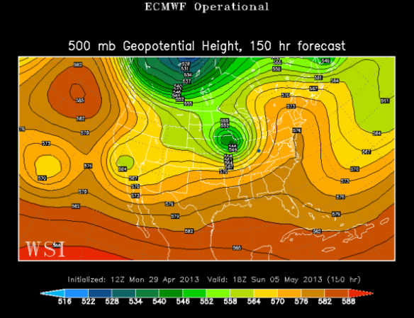
Which run of the GFS should a meteorologist believe? Maybe this morning’s ECMWF model will help us decide; it puts the area of low pressure over Iowa Sunday afternoon:

apr29-12zec18zsunday

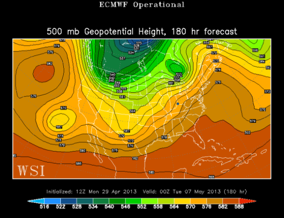
This morning’s ECMWF model has that same upper-level low nearing Toronto by Tuesday evening:

apr29-12zec00zwednesday

Clearly, there are some large discrepancies regarding where this upper-level wave is headed. For now, we are forecasting little to no rain in the Ohio Valley Tuesday, Wednesday, and Thursday and an increasing chance for rain late Friday through the weekend. At this point, it looks like the best chance for rain and thunderstorms will be Monday, but that is highly uncertain given the forecast path (or lack thereof) of low pressure 18,000 feet above the ground.

Stay tuned for a changing forecast in the week ahead!

Rain Chances Building Tonight, Cold Air Returns For Mid-Week

Only scattered showers are forecast through mid-evening, but the threat for rain will build later tonight. The threat for thunderstorms is barely there; most will just see rain – heavy at times – after midnight.

Clouds will stay thick through the night. The most recent satellite and radar data snapshot shows scattered showers in our area now, and plenty of rain along a cold front to our west.

This morning’s Microcast run does a nice job with the timing and intensity of rain tonight and tomorrow. Microcast suggests widely scattered showers will be around at 8pm tonight:

apr23-8pmtues

By midnight, Microcast keeps the best chance for rain west of Cincinnati:

apr23-12amwed

Microcast (and other models all) suggest there will be plenty of rain around overnight and early tomorrow morning; be prepared for a wet morning commute:

apr23-7amwed

Notice there will be some pockets of moderate to heavy rain early Wednesday morning. Ponding of water on the roads is the main concern for this event. The risk of severe thunderstorms and flooding is low at this point. By 5pm Wednesday, the widespread rain will be long gone and clouds will break some, as Microcast shows:

apr23-5pmwed

How much rain will we get? There are some disagreements amongst the latest round of model data on how much rain will accumulating, but most models – including Microcast – suggests most will see 1/4″ to 3/4″ of rain through tomorrow afternoon. Some may see 3/4″ to 1 1/4″ of rain:

apr23-raintotals

Colder air will sweep in behind this cold front. Light winds and temperatures in the mid 30s Thursday morning and Friday morning suggests there may be some areas of frost before the sun comes up.

Active, Rather Stormy Pattern Ahead

Today is “Day 1” of a rather active period of weather. While every day this week will not be a washout, there are significant chances for rain each day this week. April is known for showers and thunderstorms, and this week will be no exception.

Satellite and radar imagery reveals thick clouds over the Ohio Valley and showers northwest of Cincinnati as of 4:25pm:

apr15-425satrad

While some in Fayette and Union County may see a quick, passing showers through 8pm, nearly all of the Tri-State will be dry this evening and most of the overnight. By late tonight and early tomorrow, the cold front to our west (the lifting mechanism that helped to produce showers today in the Ohio Valley) will be nearing the Tri-State, allowing for showers and isolated thunderstorms to develop in the Cincinnati early tomorrow morning.

Tuesday will be mostly cloudy with rain and scattered thunderstorms. Given dewpoints in the 60s and temperatures gradually rising through the 60s and 70s tomorrow, strong and severe storms are possible. The Storm Prediction Center has placed most of the Tri-State under a SLIGHT risk for severe storms tomorrow:

apr15-slight

Based on the latest model data, large hail and damaging straight-line winds will be the main severe weather threats Tuesday. The tornado threat – for now – is low.

Rain and thunderstorms will be more scattered Wednesday, but ample low-level moisture will support a threat for heavy rain with the strongest showers and thunderstorms. This morning’s WRF models suggests dewpoints will be in the low to mid 60s (yellow and orange colors) Wednesday afternoon:

apr15-td2pmwed

This morning’s WRF model suggests showers and thunderstorms will affect most of the Ohio Valley, Mississippi Valley, and the Great Lakes by late Wednesday afternoon (largely in part to this surge of low-level moisture):

apr15-4pmwed

Thursday will be very similar to Wednesday. This morning’s WRF models suggests dewpoints will be in the low to mid 60s (yellow and orange) Thursday afternoon:

apr15-td2pmthur

As a result of this low-level moisture, the same WRF model suggest showers and thunderstorms will be widespread to our north and west at 8am Thursday morning; the coverage and intensity of showers and storms will continue building into the afternoon and evening:

apr15-8amthur

In addition to a stalled out front in the area, ample low-level moisture, and warm air in the region, a large upper-level disturbance will approach us Wednesday, Thursday, and early Friday. This morning’s GFS model suggest this disturbance will take on a “bowling ball” shape by Friday morning:

apr15-fri8amvort

This “bowling ball” shape – especially this time of the year – is usually a catalyst for severe storms if other conditions are present.

The primary focus for strong and severe storms this week will be Thursday night and Friday ahead of this disturbance and with a strong cold front coming through. It is too early to discuss specifics on severe weather threats and timing.

Investigating A Threat For Severe Storms Wednesday Night And Thursday

A strong cold front will sweep through the heart of the U.S. and the Ohio Valley tonight, Wednesday, and Thursday. There is still uncertainty about the exact timing and strength of storms in the Tri-State late Wednesday night through Thursday evening, but the threat for severe weather will be higher southwest, west, and south of Cincinnati through Thursday night.

In addition to the cold front, the driving force behind the severe weather threat Thursday will be a large upper-level disturbance moving in from the west. This morning’s GFS model has that upper-level disturbance (in orange and red) to our west early Thursday morning:

apr8-gfs8amthur

This disturbance is a lifting mechanism, so showers and thunderstorms will be likely ahead of it. This morning’s GFS model has this upper-level energy to our north and east by Friday morning, as the cold front pushes east:

apr8-gfs540amfri

The future radar product from this morning’s WRF model suggest showers and thunderstorms will be staying to our north, northwest, and west at 2am Thursday:

apr8-wrf2amthur

By 8am Thursday, the WRF morning suggests showers and thunderstorms will be approaching the Tri-State from the west:

apr8-wrf8amthur

In this particular radar snapshot, more green and yellow colors over orange and red colors suggests showers and storms will arrive in a weakening mode as temperatures drop overnight.

The severe weather threat, however, will continue through Thursday early evening. The cold front will slow down as it moves through the Tri-State Thursday, so strong and severe storms remains a possibility Thursday afternoon and early evening. This morning’s WRF model shows showers and thunderstorms energizing – especially east of Cincinnati – late Thursday afternoon and early evening:

apr8-wrf8pmthur

When you break down the severe weather threat by day, the Storm Prediction Center has placed areas northwest of Cincinnati under a SLIGHT risk of severe storms Wednesday night (through 8am Thursday):

apr8-svrwed

SPC has southern, southeastern, and eastern parts of the Tri-State under a SLIGHT risk for severe storms from 8am Thursday through Thursday night:

apr8-svrthur

Damaging straight-line winds and large hail will be the main severe weather threats Wednesday night and Thursday. The tornado threat is in play, but it is the lowest of the main three severe weather threat.

Remembering The April 3, 1974 Super Outbreak

Unless you’ve recently moved to the Tri-State, the words “March 2nd” probably trigger thoughts of tornadoes and severe weather. If you’re a long-time resident of the Tri-State, you’ll likely remember where you were on April 3, 1974. Often coined the “Super Outbreak,” April 3, 1974 was the date of the one of the biggest tornado outbreaks on record in this country and in the Cincinnati area.

11 tornadoes affected the Tri-State that day, killing 8 and injuring dozens. While it no longer stands as the deadliest severe weather day in the Tri-State on record (10 Tri-State deaths are blamed on the March 2nd, 2012 tornadoes), 5 violent (F4/F5) tornadoes occurred in Tri-State on April 3, 1974 (the most for a single event):

apr3-digits

Note that one of the strongest tornadoes that day was also the deadliest, killing 36 and injuring over 1,150 people in Greene and Clark County, Ohio.

Locally, April 3, 1974 is often remembered for the Sayler Park tornado…a rare F5 that killed 3 people in Hamilton County. This is the only F5 or EF5 tornadoe confirmed in the Tri-State since official records began in 1950. While the Sayler Park tornado was the deadliest tornado in the Tri-State that day, there were numerous other strong tornadoes in the Tri-State on April 3, 1974:

apr3-tornadotracks

Violent (F4/F5/EF4/EF5) tornadoes are rare in the Tri-State. The April 3, 1974 Super Outbreak is the only severe weather event since 1950 to produce more than 1 violent tornado:

apr3-violentbyyear

Until the March 2, 2012 outbreak, the outbreak of April 3, 1974 held the record for the most tornadoes locally in a single day. Outside of April 3rd, only one other tornado was confirmed in the Tri-State in 1974. 1974 currently takes 2nd place on the list for the most number of tornadoes in the Tri-State and in a single year:

apr3-torbyyear

What are your memories of the April 3, 1974 Super Outbreak? Were you in Cincinnati? Did you see any of the tornadoes that day? Please leave your memories in the comment section of this blog or on social media (“Meteorologist Scott Dimmich” on Facebook, @ScottDimmich on Twitter, and as “Scott Dimmich” on Google+).

Perspective On Cold So Far In 2013

Compared to last winter, this winter has been very cold and very snowy. Compared to average, however, this winter overall was warmer but snowier than average. The lingering cold is getting warm weather lovers antsy for spring and summer.

Most in the Tri-State dropped into the low and mid 20s early Monday morning. The luckier spots only dropped into the upper 20s:

apr2-earlyamlows

Monday’s early morning low of 22° at the Cincinnati/Northern Kentucky International Airport is a new record low temperature. Another low temperature will likely be broken Tuesday when we drop to 21° (the current record low temperature is 23°, set in 1992).

It is unusual to be this cold in April. 62% of all days so far in 2013 have featured a high temperature below average in Cincinnati. We’ve had over 2′ of snowfall since last summer in the Queen City. With all of this being considered, it could and has been a lot worse.

When you take the high and low temperature each day and average them, you get the “average temperature.” When you take the average temperature for each day so far this year and average them, you get the year-to-date average temperature. When you take this year’s year-to-date average temperature and compare it to other years, 2013 (so far) is only the 47th coldest year (to date) on record:

apr2-coldestytd

This graph suggests we have have a lot to be thankful for this year…46 reasons! Those of you know who remember the winters of 1976-1977 and 1977-1978 know true cold.

Part of this year being the 47th coldest year-to-date can be blamed on a colder than average March. In fact, March 2013 was the 13th coldest March on record in Cincinnati (average temperatures in the graph are rounded to the nearest tenth):

apr2-coldestmarches

14 of 31 days in March 2013 had a high temperature 10° or more below average. Brief spikes in warmth did little to curve the average up.

While below average temperatures have been common since the year began, there have been relatively few brutally cold nights. We’ve only dropped to 7° twice this year in Cincinnati. Our coldest night of the fall, winter, or spring – including i the last several years – is often near or below 0°:

apr2-coldestfalltospring

There’s no doubt this year has been colder than average so far. We got spoiled last year with the second warmest March on record, a very mild winter, and very little snow. Spring is a season of transition, and this year’s transition from cold to warm will be gradual and come in spurts. Warmer air is coming later this week, and before we all know it, we’ll be complaining about the heat and humidity.