
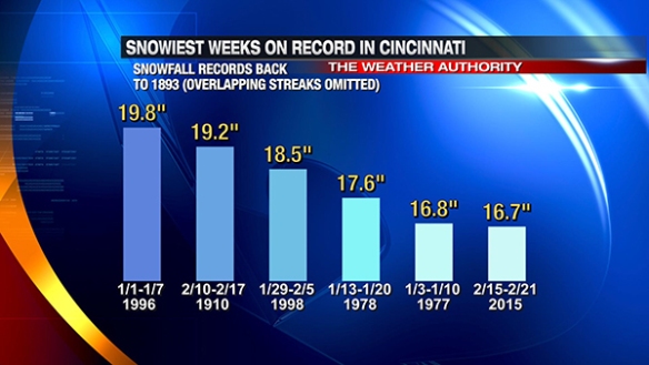
There have been three significant winter storms in the Tri-State during the last 7 days. It is rare to have frequent rounds of heavy snow in Cincinnati. In fact, the last week ranks as the 18th snowiest week on record in Cincinnati. If you omit the overlapping streaks, Cincinnati just had it’s 6th snowiest week since 1893:
February is typically the snowiest month of the year in Cincinnati (with 6.53″ of snowfall on average); January is a close second with an average of 6.51″ of snowfall. Despite being the snowiest month of the year, it is rare to see more than 10″ of snowfall in a week during February; the last 7 days were among the snowiest during February back to 1893 :

This abnormally snowy stretch has pushed us to 5th place on the snowiest Februarys on record in Cincinnati:

…and the month is not over. The amount of snowfall recorded at the Cincinnati/Northern Kentucky International Airport in the last 7 days is 92% of the amount of snow that typically falls in all of meteorological winter (December, January, and February combined):

It’s worth noting that more snow has fallen in the first 21 days of February 2015 (18.6″) than falls during meteorological winter on average (18.1″). The snowfall total for meteorological winter 2014-2015 through February 21st is 19.9″.
The seasonal snowfall total through February 21st is now up to 25.0″. On average, 22.5″ of snowfall is recorded in Cincinnati from one summer to the next. All snow that accumulates for the rest of the winter and spring just adds to the surplus.
This winter has been “bottom heavy.” More than double the amount of snow that fell between last summer and February 14th has fallen in the last week:

“Bottom heavy” describes not just snowfall accumulation this winter, but it also describes cold. If February had ended at midnight on Sunday, February 2015 would be the 8th snowiest February on record:

If meteorological winter 2014-2015 had ended at midnight February 21st, it would rank as the 19th coldest back to 1870-1871. There is still plenty of time for our ranking to change, but it doesn’t look like the ranking going to slide down. Saturday morning’s American long-range (GFS) model has arctic air plunging into the Great Lakes and Ohio Valley to start off the work week:

It has another shot of arctic air coming late in the work week:

Saturday morning’s European long-range (ECMWF) model is similar to the GFS, bringing an arctic airmass into the Ohio Valley and Great Lakes Monday morning:

…and another area of arctic air to the Ohio Valley before next weekend begins:

The first blast of arctic air will likely bring temperatures of -5° to 5° to the Tri-State early Monday and Tuesday morning. The second blast will bring temperatures back into this range Thursday and Friday morning.
Winter is far from over. At least a few more waves of very cold air and snowy will swing into and through the Ohio Valley during the next 2 months. Temperatures will moderate some in March, but cold will win out for the next several weeks.