The Truth About Next Week’s Cold

While models have wobbled more than usual with the handling of weather systems recently, the latest computer model runs all suggest a large piece of arctic air will drop into the Ohio Valley next week. The specifics about the timing and strength of the cold plunge are nowhere close to being finalized, but a signal of very to extremely cold temperatures should be taken seriously.

There is already a lot of hype about next week’s cold blast on social media. Some models are producing very cold temperatures for the Tri-State next week, while others are suggesting we’ll come close to setting all-time record low temperatures. These same models may change their tune later this week and over the weekend, but for now, they all agree that cold (in some form) is coming soon.

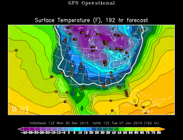
For the sake of simplicity, I’ll focus on next Tuesday morning (January 7th). This morning’s GFS model pushes temperatures to around 0° in Cincinnati that morning:

dec30-gfsop

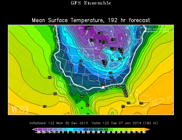
The GFS model ensemble members averaged together suggests we’ll drop between 5 and 10° above zero:

dec30-gfsensemble

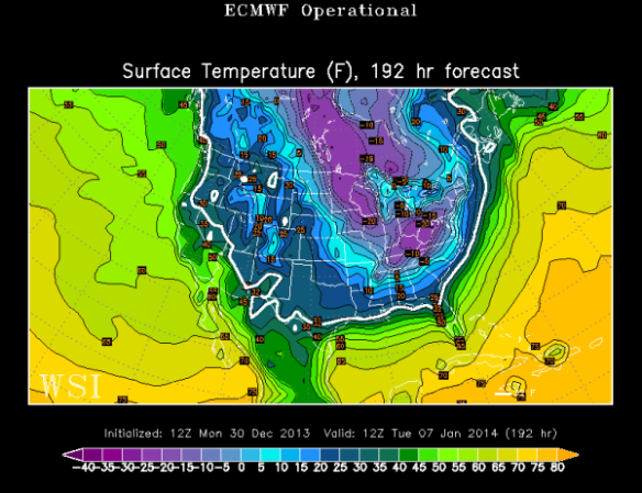
This morning’s ECMWF model says the Tri-State will drop between -10° and -25° below zero Tuesday morning:

dec30-ecoper

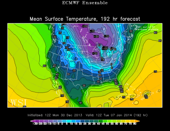
Meanwhille, the ECMWF model ensembles averaged together drops Cincinnati between 0° and -5°:

dec30-ecensemble

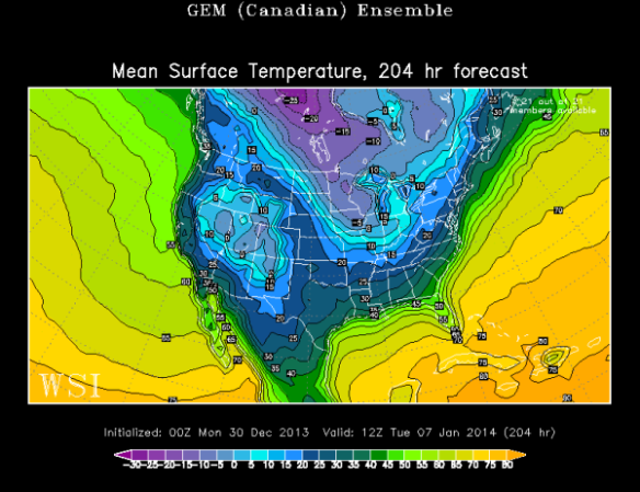
The Canadian model ensembles averaged together – which tends to do well with extreme cold – drops the temperature to around 10° in Cincinnati early next Tuesday morning:

dec30-cmcensemble

Clearly, there is a large spread on overnight lows from one model to the next. Long range forecasting can be very tricky, especially when dealing with the timing of disturbances more than a week out.

Long range forecasting is especially hard this time of the year because:

– The lack or depth of a snowpack can have a large influence on temperatures
– Models tend to overdevelop areas of low pressure in the winter, and – thus the amount of cold air behind departing behind them
– Cloud decks are also tough to forecast more than one week out, especially stratus decks and low-level inversions/stable layers of air aloft

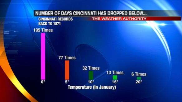
For these reasons and others, forecasting temperatures for next week now is difficult at best. While models may not agree with each other, they are sending a signal of brutal cold. Here’s a list of how many times Cincinnati has dropped below certain temperatures in January since 1871:

dec30-coldtimes

What are the historical odds that the low temperature on any given January day in Cincinnati will drop below these same temperatures?

dec30-historicalodds

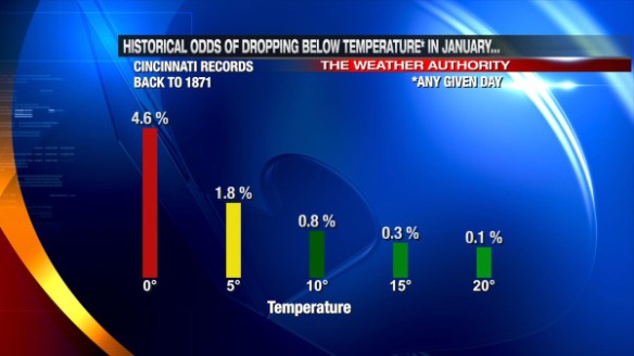
On average, Cincinnati drops below 0° two days each January. There have been many years where we didn’t hit 0°, but there have also been years where we hit or dropped below 0° frequently (16 days in January 1977).

A lot is needed to get a temperature well below zero in Cincinnati. Notice that all of the top 10 coldest mornings on record in Cincinnati had at least two inches of snow on the ground:

dec30-coldestlows

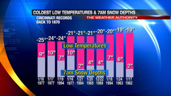
The presence and amount of snow on the ground in Cincinnati has a big impact on how cold we get at night. The presence and amount of cloud cover at night has a impact on how cold the Tri-State gets. The amount of snow to the north and west of Cincinnati (even as far back as the Plains and Dakotas) can have a big impact on how low temperatures go. Just as drought begets drought and wet begets wet, cold and snow begets cold and snow. A dense snowpack from the Ohio Valley to the Plains is often a major contributor to record cold, as arctic air from Canada “holds together” better when it travels south.

Simply put, we are getting signals from recent computer model runs about a significant surge of arctic air next week. Some models suggest we will see near-record cold, but this is highly dependent on the extent of cloud cover and snow cover in the Ohio Valley in the coming days. Stay tuned for what could be one of the biggest – if not the biggest – polar plunges we’ve had the Tri-State in the last couple of years!

Perspective On How Rare Saturday’s Weather Was

Did Saturday’s weather seem unusual to you? It was. In fact, it was very unusual by several different measures. Heavy rain is not common in December, and severe weather isn’t either. We had plenty of both this weekend, fueled by an abundance of warmth and low-level moisture.

How does one measure the weirdness of weather? The easiest way to do this is by variable.

It was hard to ignore the rain this weekend, especially with Friday, Saturday, and Sunday being some of the biggest travel and shopping days of the year.

Rainfall totals varied from one community to the next, but most fell into a 1-3″ range; some were just outside the range:

dec22-rainfallmap

While 1-3″ is a significant amount of rain, it doesn’t always lead to problems. For this event, however, it caused widespread flooding thanks to one of the snowiest starts to December on record and temperatures in the 40s, 50s, and 60s before, during, and after rain was falling. Tri-State soils were wet to soaked before rain fell in many communities, and 1-3″ of rain on top of a saturated ground means flooding is imminent.

The 2.29″ storm total at the International Airport is about 68% of the average amount of precipitation (rain + melted down snow and ice) Cincinnati gets in the entire month of December. 1.86″ of that total fell between midnight Saturday and midnight Sunday, making Saturday, December 21st the 15th wettest December day on record (since 1870) in the Queen City:

dec22-wettestdecdays

A surplus of low-level moisture and a surge in warmth helped to support the widespread rain and storms that passed through the Tri-State Friday, Saturday, and Sunday. Since reliable hourly weather records began in Cincinnati in 1939, the highest dewpoint recorded in Cincinnati during the month of December was 65°. At the Cincinnati/Northern Kentucky International Airport, the dewpoint hit 63° several times Saturday. A dewpoint of 63° is abnormally high for Cincinnati in December and almost tied the dewpoint “record” set in 1948:

dec22-decdewpoints

Temperatures were also well above average, helping to create some instability. Our high of 68° was 1° from matching the record high of 69° set in 1967. Here’s a map of Tri-State high temperatures Saturday:

dec22-sathighs

Oddly enough, the weather setup in 1967 (when the record high was set) was similar to Saturday’s. After a dry morning and a rapid warm up from the 40s into the 60s on December 21, 1967, a cold front came through that unloaded 1.06″ of rain; the following day featured a low in the 20s, a high in the 40s, and some flurries in the morning. Similar  to those days in 1967, we’ll start tomorrow around 30°, finish in the upper 30s, and have some flurries and sprinkles in the morning.

In my opinion, what make Saturday unique – or perhaps historic in some ways – was the presence of severe thunderstorms. From the time the National Weather Service Forecast Office in Wilmington first started issuing warnings for the Tri-State in 1995 to the start of this month, only 4 Severe Thunderstorm Warnings had been issued in the Tri-State during the month of December; all of them were issued on December 1, 2006 when a line of storms traversed the Ohio Valley. In this same time period, no Tornado Warnings and only 3 Flash Flood Warnings were issued in the Tri-State.

Last night, 8 Severe Thunderstorm Warnings, 6 Flash Flood Warnings, and a Tornado Warning were issued in the Tri-State. In other words, more Severe Thunderstorm, Tornado, and Flash Flood Warnings were issued in the Tri-State last tonight (both individually and added together) than in all December days from 1995 to 2012 combined.

After a very quiet spring and summer severe weather season, here are the latest warning totals for 2013 compared to the yearly records and averages:

dec22-warningtable

Saturday’s severe weather event and the severe weather event that hit in the Tri-State on Halloween were unique in that damaging straight-line winds were caused more by showers than thunderstorms. Radar data showed a well-defined, narrow line of showers and isolated thunderstorms entering the Tri-State just before 9:30pm last night:

dec22-924pmradar

…and east of the Tri-State around 1:30am:

dec22-124amradar

Showers and storms were moving quickly (50+ mph) last night, and their speed and outflow alone was enough to cause damage. In real-time, there was no strong indication that warnings were verifying. The peak wind gust map from last night (including observations from local airport and weather stations) suggests there was little to no damage (60+ mph winds are usually needed to cause damage):

dec22-peakgustmap

When the sun came up and flooding concerns eased some overnight, people found more damage, but most that got damage just had trees or limbs down.

When you get off the beaten path, even more complex weather records were set on Saturday. The precipitable water (atmospheric water content) value measured by Saturday night’s weather balloon launched at the NWS Wilmington around 7pm set a December record (records began in 1948). In the graphic below, the green line represents the monthly records, and the “X” shows last night’s value broke the December record (and was 321% of the December average):

dec22-pwgraph

Regardless of how you measure Saturday’s weather, it’s hard to say it wasn’t unusual, atypical, or just plain weird. As a meteorologist who has worked for several years in the Ohio Valley, you never quite know exactly what you’ll see any given year. After a record number of tornadoes last year, this year has been quieter than usual and with nearly all of our severe weather coming late in the year.

Thankfully, the next few days look quiet with some bouts of flurries and near or below average warmth.

This Weekend’s Weather Setup And Why I Don’t Like It

There are several things about this weekend’s weather setup that are troubling. First, waves of heavy rain are forecast this weekend, this after a couple days of snow melting to saturate the ground. Second, there is a threat for strong and severe storms this weekend in the Ohio Valley; after a quiet spring and summer, this fall and now winter has been very stormy. Severe weather events in the Tri-State during the month of December are very rare.

Several disturbances will affect the Ohio Valley Friday through Sunday; the thinking on the strength and timing of each has not really changed in the last 24 hours.

The latest computer forecast model runs all have widespread light to moderate rain in the Tri-State Friday morning and afternoon:

fridaymodels

This initial round of rain is not going to cause widespread problems, but it will help to saturate the ground. Models have widespread moderate to heavy rain moving in Saturday afternoon and evening:

saturdaymodels

Moderate to heavy rain continues into early Sunday with the center of low pressure to the northwest of Cincinnati:

sundaymodels

Given the dewpoints in the 50s and 60s, temperatures in the 50s and 60s, the positioning of the jet stream, and modest instability, thunderstorms are forecast from Saturday afternoon through Sunday. In addition to the threat of thunderstorms, there is also support for strong and severe storms in the Tri-State Saturday night and early Sunday. Being south of the warm front and east of the cold front puts us in the “warm sector,” or the warm, moisture-rich airmass that will support storms. Specifically, there is a concern for damaging straight-line winds early Sunday morning.

The latest NAM model run has 60-100+ mph winds 5,000 feet above the Ohio Valley at 1am Sunday:

nam850

This morning’s GFS model run has the strongest winds positioned differently but just as strong early Sunday morning:

gfs850

This fast moving zone of winds just above the ground is called the low-level jet. It typically strengthens before and during severe weather events, but these speeds are abnormally strong for late December. Mathematically speaking, these wind speeds are 3-5 standard deviations above average for this time of the year. Simply put, these wind speeds are rare to very rare for December. Winds 5,000 feet above the ground are often transferred to the ground – in part or whole – when heavy rain is falling. With moderate to heavy rain forecast as these winds are coming through, there is a concern for severe winds Saturday night and early Sunday morning.

While instability can often have a big influence on the chance for thunderstorms, it isn’t as important this time of the year. If thunderstorms are likely (which they are Saturday night and Sunday), the SHERB parameter or index can be very helpful to a meteorologist in the colder months when looking a threat for severe weather. The SHERB parameter is helpful for getting a handle on a severe weather threat in the colder months because it focuses on temperature changes near the ground, lift in the atmosphere, and wind shear instead of instability (instability tends to be low in the winter even when we get severe weather).

Why is SHERB important? Unlike summer severe weather events which are driven by high instability and less of everything else, cold season events are driven by everything else and not often by instability. SHERB is a special blend of “everything else” that is important when gauging a severe weather threat…which makes it valuable when we don’t have summer-like heat and humidity. When SHERB values are high and the chance for rain and storms is high, severe weather is often a concern.

SHREB values on Saturday night and early Sunday morning are elevated in the Ohio Valley. This morning’s NAM model has SHREB values that are high (yellow) and support a Tri-State severe weather threat (Cincinnati is the black dot):

sherb

SHERB tells us that instability isn’t really necessarily to get rough storms Saturday night and early Sunday. Any instability will only aggravate the atmosphere more than it is already primed.

Plus, there is a threat for heavy rain and flooding this weekend. The Weather Prediction Center has already placed the Tri-State in a MODERATE risk for excessive rainfall from 7am Saturday to 7am Sunday:

hpc

A Flood WATCH is likely coming for most if not all of the Tri-State later today. It will likely be in effect most if not all of Saturday and Sunday.

Here is how much rainfall various models are forecasting from 7am Friday to 7am Monday:

NAM         1.72″
ECMWF: 1.94″
GFS          5.40″

The GFS is clearly overdone, but 1-3″+ of rainfall is likely Friday, Saturday, and Sunday.

Be prepared for flooding and storms this weekend!