Forecast & Severe Weather Update

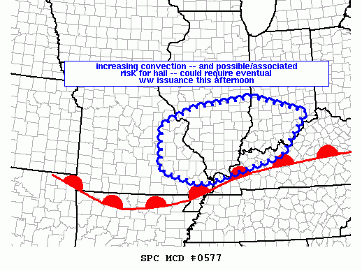
As of 3:15pm, the Storm Prediction Center is considering the issuance of a Tornado or Severe Thunderstorm WATCH for parts of the Ohio Valley including the western Tri-State:

mcd0577

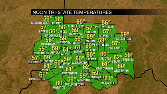
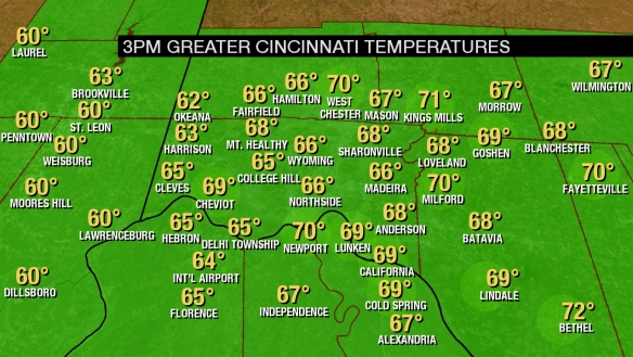
Temperatures are rising through the 60s and 70s as of 3pm, increasing the amount of instability and likelihood for strong and severe storms:

temps

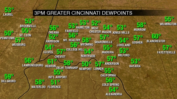
Dewpoints have also been rising this afternoon, and this is an impressive rise since this morning when dewpoints were in the the 40s:

dewpoints

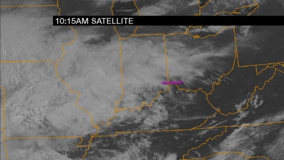
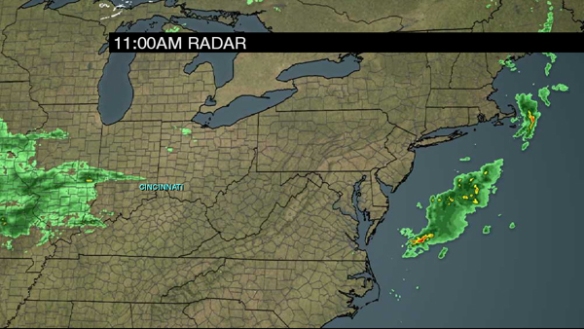
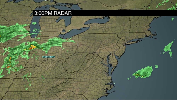
A 3pm radar snapshot shows showers and thunderstorms developing to the west of Cincinnati and Tri-State:

radar

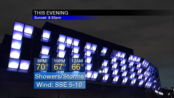
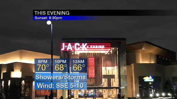
Current thinking is that showers and storms will rapidly develop and increase in coverage late this afternoon and early this evening and continue in waves through the second half of the evening and overnight:

evening

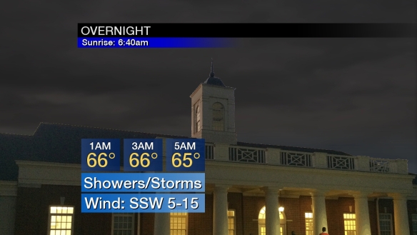
The coverage of showers and storms will gradually drop late in the overnight, but flash flooding is the main concern from late evening through sunrise:

overnight

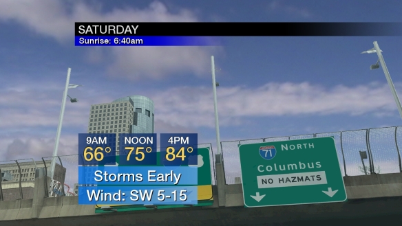
Showers and thunderstorms will be favored early Saturday, then partial clearing and rapid warmup comes during the afternoon:

saturday

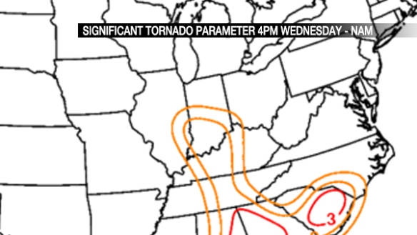
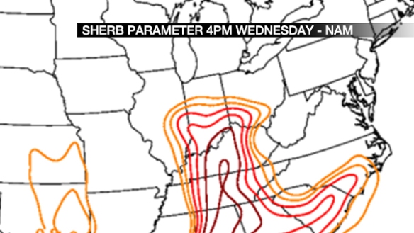
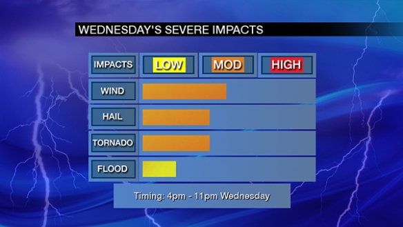
I have increased the threat for tornadoes, flash flooding, and large hail slightly from my last update this morning:

impacts

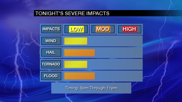
The tornado threat is focused along and south of the Ohio River through early evening. The other threats are distributed around the entire Tri-State.

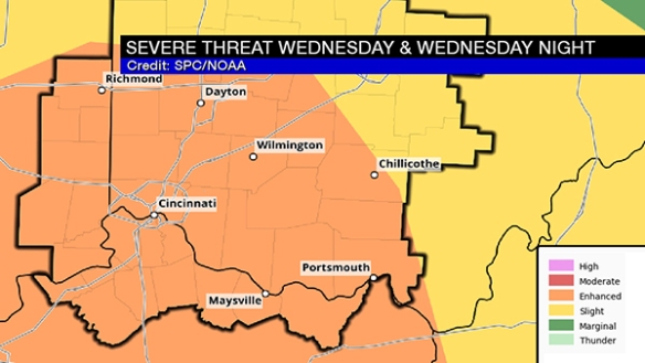
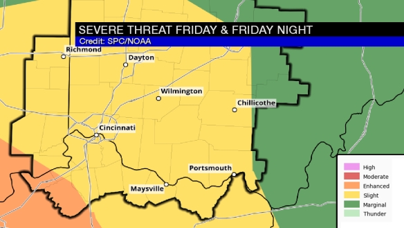
The Storm Prediction Center still has the entire Tri-State in a slight to enhanced risk for severe storms through sunrise Saturday:

impacts

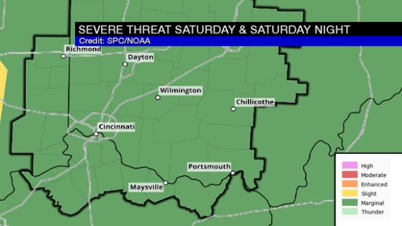
The threat for severe storms Saturday and Saturday night will be focused northwest of Cincinnati:

spc2

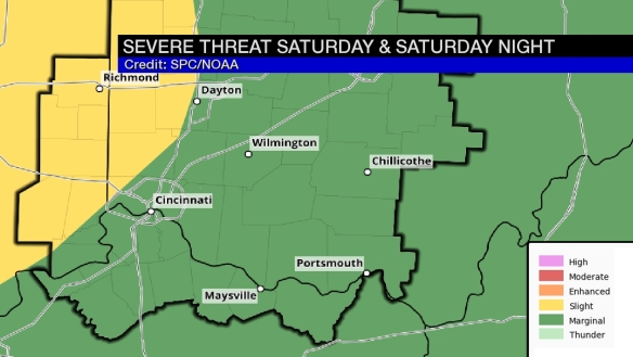
This is forecast the threat of strong storms very early Saturday and also late Saturday night/early Sunday.

If you’re tired of this warm and stormy pattern, longer-range guidance has us much cooler next week:

temptrend

Let’s Talk About The Severe Threat Later Today

Are you aware that strong and severe storms are a possibility later today? You should! If not, let’s break down the threats and timing.

The Storm Prediction Center has placed the Tri-State in a slight to enhanced risk for strong to severe storms through sunrise on Saturday:

The risk is driven by the large hail threat, but the threat for damaging straight-line wind and flash flooding are still significant. The tornado threat is in play, but it is a secondary threat at this time. Here’s a breakdown of how I see severe threats for later today:

Notice that the threat for severe storms is focused after 5pm today and throughout the evening. Additional rounds of thunderstorms are likely after midnight, but the atmosphere will likely be worked over pretty hard by then. Even with this considered, you should be weather aware through the tonight, including through the overnight.

There is also a Flash Flood Watch in place for most of the Tri-State from 7pm Friday through 11am Saturday:

Temperatures are the in process of rising through the 50s and 60s as of 11am:

…and dewpoints are also rising:

These numbers are not supportive of severe storms, but dewpoints will be rising through the 50s and 60s this afternoon and evening. This will support an increasing threat for thunderstorms – including severe storms – as the day and evening progresses.

A visibile satellite snapshot shows why the threat for severe storms is highest over central Kentucky and southwest of the Tri-State…more sunshine:

The first wave of showers will float through the Tri-State this afternoon (especially between now and 3pm) and is already appearing on radar:

These showers and storms are moving northeast at 45mph.

Showers will develop this afternoon, but the threat for thunderstorms will wait until late this afternoon and evening. Notice temperatures will rise through the 60s and 70s this afternoon:

Showers and thunderstorms are likely from late afternoon through this evening in waves:

Some storms may be strong or severe through tonight. Also, note that the Tri-State is in a marginal risk for severe storms Saturday:

This is an evolving threat, so stay weather alert through the day, evening, and throughout the weekend!

Let’s Talk About Wednesday’s Severe Threat

The Storm Prediction Center has placed the entire Tri-State in an ENHANCED risk for severe storms Wednesday and Wednesday night:

apr4-blog-spc

This is a significant threat for strong and severe storms, but – as I will highlight below – it is conditional on how warm and unstable the low-levels of the atmosphere get.

First, let’s address how we get there. We’re around 60° as of noon:

apr4-blog-11amtemps

Clouds will win out over sun today, but at least some cracks in the clouds will allow the temperature to rise. Here’s a cloud snapshot as of 11:15am:

apr4-blog-1015amclouds

Temperatures will rise into the low and mid 60s this afternoon under a mostly cloudy sky:

apr4-blog-afternoon

Partial clearing is forecast this evening with temperatures falling through the 60s and 50s:

apr4-blog-evening

Clouds will increase and thicken Wednesday. From mid-morning through mid-afternoon, scattered showers and stray, non-severe storms will develop. The coverage and intensity of storms will increase between mid afternoon and early evening. The environment these storms will be in is important. For this, we’ll use the NAM model from Tuesday morning, which has a higher resolution than most models and has a decent handle on the overall setup.  It shows an intensifying upper-level disturbance around 18,000 above the ground at 4pm Wednesday:

apr4-blog-vort

This will provide lift in the atmosphere and help to generate storms. The Significant Tornado Parameter (the higher the number, the more likely tornadoes are if other conditions are supportive) shows the tornado threat focused over Indiana at 4pm Wednesday, but that threat will diminish (but still be more than high enough to watch) and move east from 4pm Wednesday through late evening:

apr4-blog-sigtor

The SHERB parameter (an index of severe thunderstorm in low-instability/high-shear environments; see more in this blog post) shows a significant threat for strong to severe storms in the Ohio Valley late Wednesday afternoon and Wednesday evening. Values in the red usually gather my attention:

apr4-blog-sherb

If thunderstorms form Wednesday, how likely are they to rotate? A good indicator of this is storm relative helicity. In simple terms, a tightly-thrown spiral on a football tossed straight up into the sky has good helicity. Here is what the NAM model thinks for helicity at 4pm Wednesday:

apr4-blog-srh

That bubble of 200 (m2/s2) is enough to get my attention and support a tornado threat.

There is, however and as discussed above, uncertainty on how much instability we get. Dewpoints are forecast to rise into the upper 50s Wednesday afternoon, but the instability forecast is messy. Weak instability means a lower severe threat.

Here’s my overall thinking on Wednesday’s severe weather threat as of Tuesday afternoon:

apr4-blog-impacts

The window for severe storms is 4pm to 11pm Wednesday, but the highest threat centers between 5pm and 8pm Wednesday.

Remember, this is not a final forecast. Conditions and guidance may change in the next 36 hours.