Severe Storm, Flooding Threat Thursday

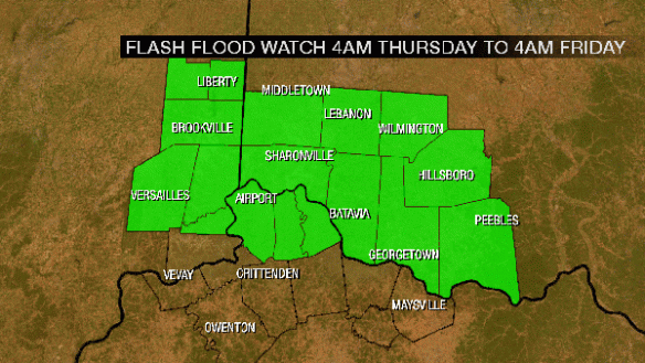
Thanks largely to warm, steamy air, there will be an elevated risk for flooding and flash flooding in the Tri-State Thursday and Thursday night.

First, most of the Tri-State is in a Flash Flood Watch from 4am Thursday through 4am Friday for the potential of heavy rain leading to flooding:

jul12-ffw

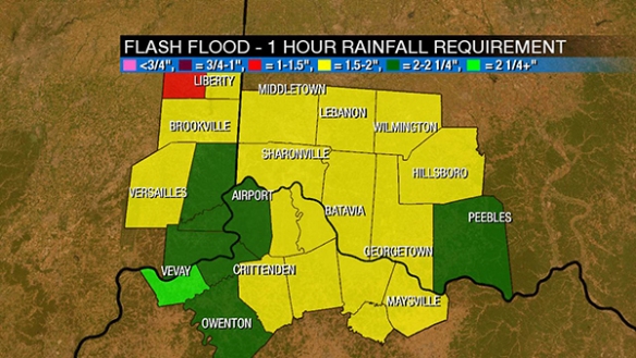
How much rain will it take to get a Flash Flood Warning? Here’s 1 hour flash flood guidance:

jul12-ffg1

Here’s 3 hour flash flood guidance:

jul12-ffg2

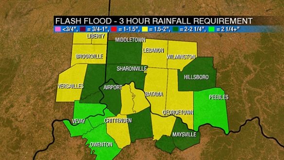
6, 12, and 24 flash flood guidance is not worth showing. The summary here is that it must rain quickly and heavily to get flash flooding. Thunderstorms will be needed to get flash flooding tomorrow. 1.5″ of rain per hour will likely trigger warnings.

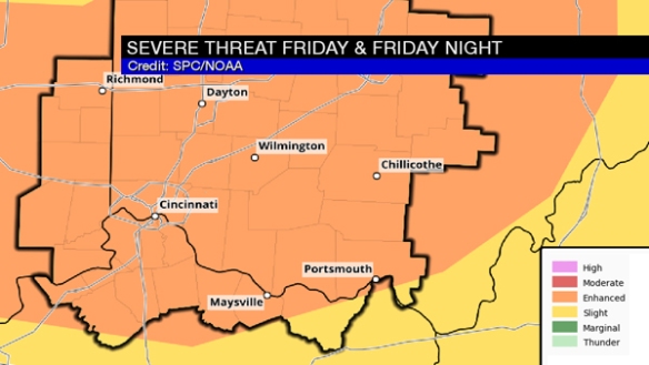
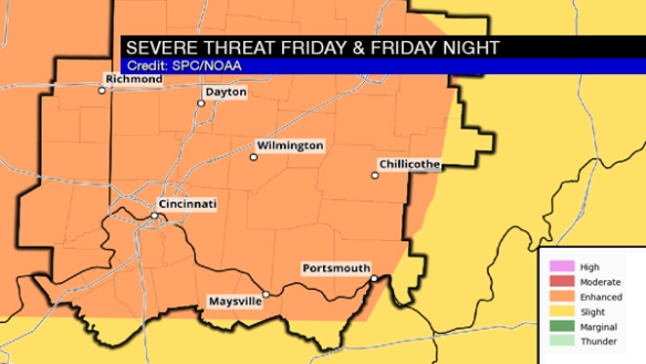
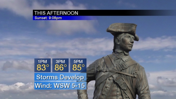
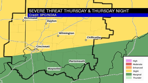
There is also a slight risk for severe storms over most of the Tri-State tomorrow:

jul12-spc1

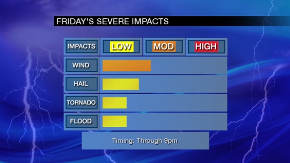
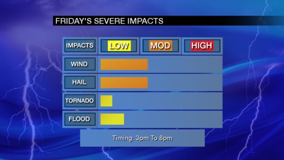
As I see it, there is a lot of instability to fuel storms, but other ingredients for severe storms are surprisingly absent. Here are my forecast severe weather impacts for Thursday:

jul12-impacts

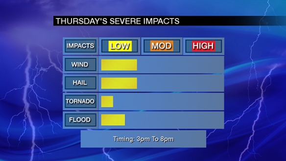
Notice the most likely time for severe storms Thursday centers between 3pm and 8pm.

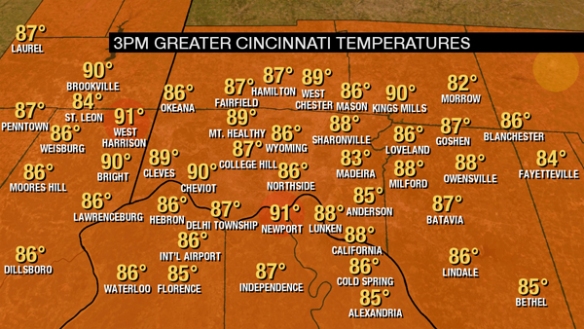
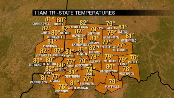
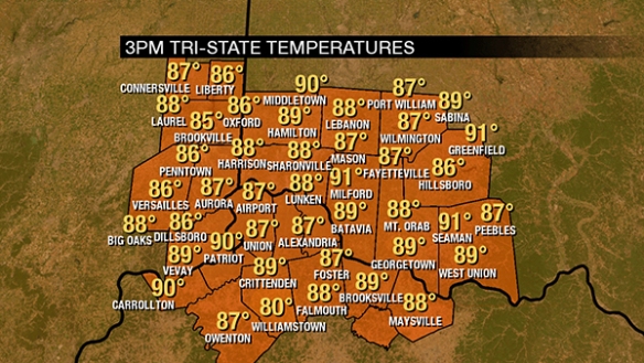
As of 3pm, it’s warm outside:

jul12-temps

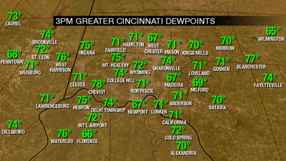
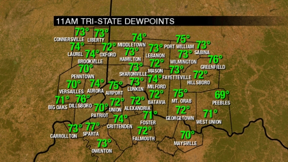
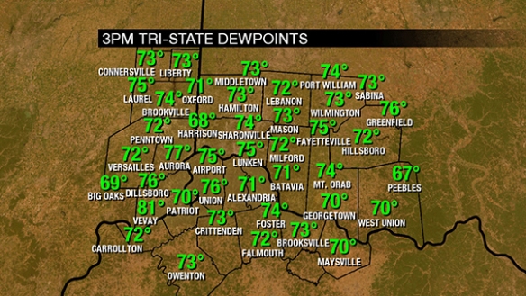
It’s also disgustingly humid outside, with dewpoints well into the 70s:

jul12-3pmdewpoint

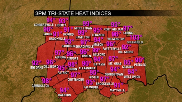
This means heat indices are over 90° for many:

jul12-feels

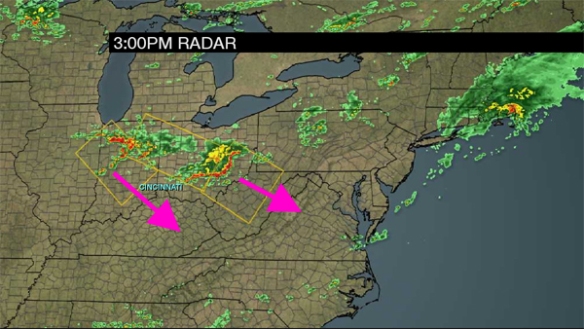
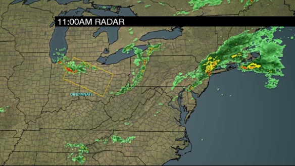
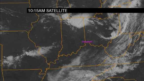
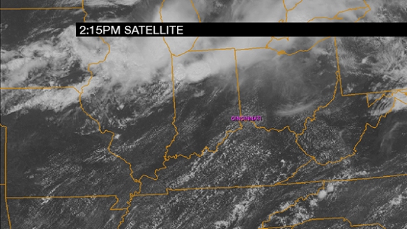
There are showers and storms developing over central Indiana at this time:

jul12-215pmclouds

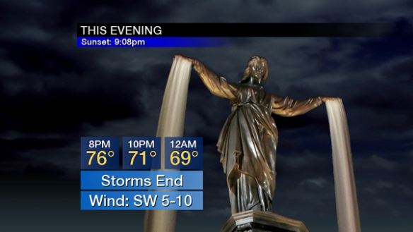
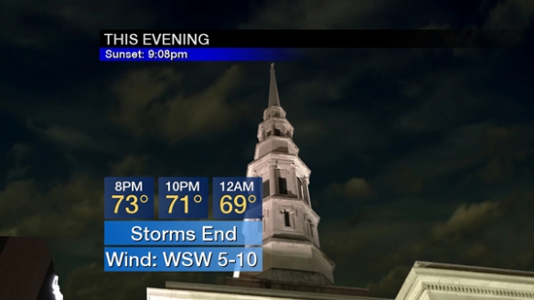
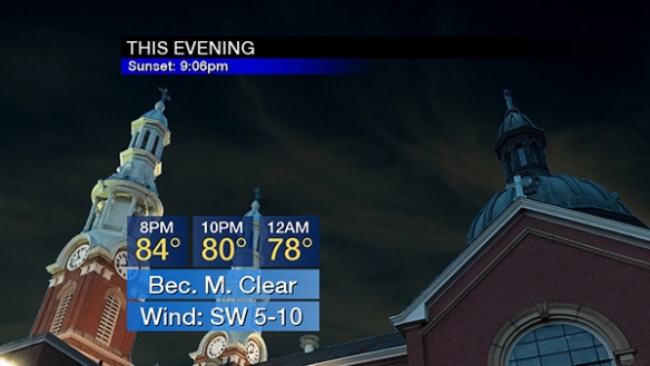
Current thinking is as isolated showers and storms will brush into communities northwest of Cincinnati early this evening before the sky becomes mostly clear tonight:

jul12-evening

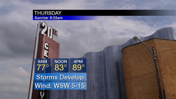
After isolated showers and storms in the morning, showers and storms will develop and increase in coverage Thursday afternoon:

jul12-thursday

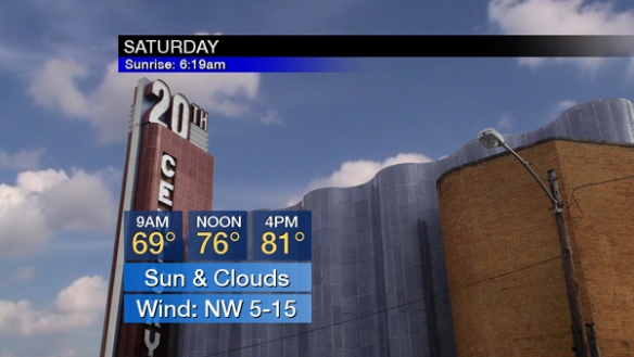
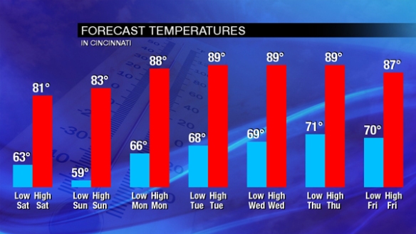
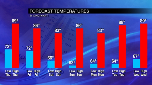
Showers and storms will diminish Thursday evening. They will be isolated overnight Thursday night and scattered Friday. The weekend will be quiet and peaceful but also humid. More heat is coming next week:

jul12-temptrends

Be alert for heavy rain and strong to severe storms Thursday, especially during the afternoon and evening!

Friday Afternoon Severe Weather & Forecast Update

Thanks to ample sunshine, more supportive temperature profiles in the atmosphere, and an increase in the amount of wind shear over the last few hours, the threat for severe storms remains elevated despite a weak round of storms northeast of Cincinnati now. Radar shows those storms and stronger clusters of storms east and northwest of Cincinnati at this hour:

jul7-3pmradar

Clusters of storms over central and northern Indiana are the ones to watch. Those will expand in coverage and move southeast this evening.

Through midnight, the Tri-State remains in an ENHANCED risk for severe storms:

jul7-spcday1

Damaging straight-line is still the main threat with large hail a close secondary threat. Tornadoes and flash flooding are the lowest of the severe threats at this time:

jul7-impactsafternoon

It’s warm outside. Temperatures are in the mid to upper 80s for most as of 3pm:

jul7-3pmtemps


It’s also steamy with dewpoints in the mid 70s:

jul7-3pmdewpoints

Showers and storms will develop late this afternoon and early this evening. Showers and storms will gradually end nearing midnight. Notice the large drop in temperatures due to showers and thunderstorms:

jul7-eveningafternoon

Cooler, less humid air is coming tomorrow. After areas of fog in the morning, a mix of sun and clouds is forecast during the afternoon:

jul7-saturdayafternoon

Enjoy the break from heat and humidity this weekend, because both are coming back next week!

jul7-temptrend

You should have multiple ways to get watch and warning information this afternoon and evening. Be alert!

Today’s Severe Weather Threat Update

The Storm Prediction Center has placed the entire Tri-State in an ENHANCED risk for severe storms through this evening:

jul7-spc

The primary threats this afternoon and evening are damaging straight-line wind and large hail. Flash flooding and tornadoes are secondary threats. All of these threats are in play between 3pm and 8pm today:

jul7-impacts

There is already a Severe Thunderstorm WATCH in effect for parts of Ohio and Indiana just north of the Tri-State:

jul7-watch

Showers and storms have already developed over northeastern Indiana, and these clusters of showers and thunderstorms will expand in coverage and move southeast over the next several hours:

jul7-radar

Ahead of these showers and storms, there is plenty of sunshine:

jul7-clouds

Sunshine will boost instability levels available to storms this afternoon and evening. In addition to sunshine supporting storms, it’s also warm. Temperatures are already in the 70s and 80s, and these numbers are rising:

jul7-temps

It’s also steamy. Dewpoints are in the low to mid 70s:

jul7-dewpoint

The necessary ingredients for severe storms are already in place. Temperatures will rise through the 80s this afternoon with showers and storms developing:

jul7-afternoon

Temperatures will crash through the 80s and 70s this evening underneath the weight of showers and storms:

jul7-evening

Have more than one way to get watch and warning information this afternoon and evening!