Perspective On Fall Frost In Cincinnati

The possibility for frost in the Tri-State rises from mid-September through early October. Our first light frost (a low temperature around 38°) of the season usually occurs in early October but has occurred as early as mid-September.

Frost is more likely when the air temperature drops to or below 36°. The average date for the first fall morning in Cincinnati with a temperature of 36° or lower is in early to mid-September. A damaging frost, however, can happen as early as late September.

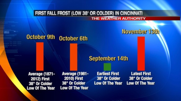
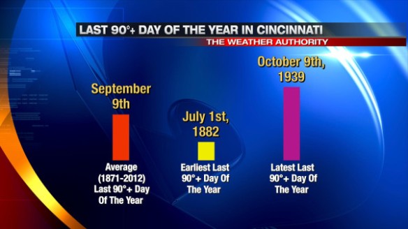
Here’s some perspective on fall frost dates in Cincinnati:

sep16-frost

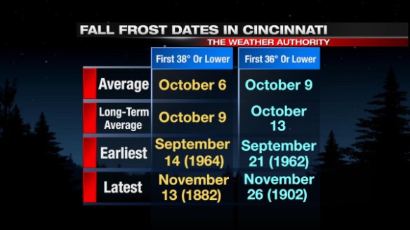
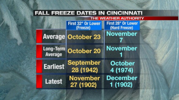
The “average” above uses temperatures data from 1981 to 2010, and the “long-term average” uses temperature data from 1871 to 2012.

A morning with temperatures to or below 32°  – as known as a “freeze” – first occurs in late October, on average. A freeze often signals the end of the growing season for most plants. The first “hard freeze” (low temperature of 28° or below) of the fall in Cincinnati typically occurs in early November. With the exception of hardiest and herbaceous crops, any plants that are able to survive a freeze will likely be killed in a “hard freeze.”

Here’s some perspective on fall freeze dates in Cincinnati:

sep16-freeze

If left outside, your plants will likely have a couple of weeks left before getting their first taste of fall frost. The latest ECMWF Weekly model run suggests late September will be near or warmer than average. I suspect our first frosts of the year will come in early to mid-October this year…right on schedule.

The Tri-State’s “Secondary” Severe Weather Season Is Approaching

After a record number of tornadoes in 2012, there have been no tornadoes and no Tornado Warnings in the Tri-State so far this year. Since the National Weather Service in Wilmington began issuing warnings for the Tri-State in 1995, at least one Tornado Warning has been issued somewhere in the Tri-State in the first seven months of the year…until 2013.

Here’s how 2013’s warning count so far compares to yearly averages and records:

sep16-warnings

Severe storms, however, don’t just occur in the spring and summer; storms can – and often do – develop each fall and even winter. In fact, some of the strongest and deadliest storms in the Ohio Valley have occurred October and November.

In just the Tri-State alone, the average number of Severe Thunderstorm Warnings issued increases slightly from September to October and again from October to November:

sep15-svrs

May, June, and July are the most common months for seeing severe storms in the Tri-State.

Tornado Warnings are more rare than Severe Thunderstorm Warnings. On average, April and May are the most common months for Tornado Warnings to be issued, but there is a subtle spike in the average number of Tornado Warnings issued in October and November:

sep16-torwarn

While the likelihood for Severe Thunderstorm and Tornado Warnings goes up some late in the year, few Flash Flood Warnings are issued after October 1st in the Tri-State:

sep16-ffws

In fact, only 5 Flash Flood Warnings have been issued in the Tri-State since 1995 during October, November, and December.

The threat for tornadoes seems to trump all other severe weather threats and tends to be the one that gets people most concerned. Statistically, April, May, and June are our biggest months for tornadoes. April’s number is partially inflated by the 12 confirmed tornadoes of April 3, 1974. While the monthly tornado count drops from August to September, it increases again through the fall:

sep16-tors

Why does the chance for severe storms and tornadoes gradually increase in the fall? The main reason is that the polar jet stream is pushing south and is almost always stronger in the fall than it is over Canada during the summer. Certain parts of the jet stream are focal points for rapidly rising air, and these focal points are usually where severe weather occurs in the fall (if other key conditions are present).

Don’t let the cooling trend fool you; autumn can be a nasty time of year, especially when warm, moist air surges north and the polar jet stream surges south.

Perspective On Mid-September Chill And The Long Range Forecast

After summer-like heat and humidity earlier this week, cooler, less humid air has returned to the Tri-State. The Weather Authority is forecasting low temperatures in Cincinnati early Saturday and Sunday morning to be in the mid to upper 40s. Communities north, northeast, and northwest of Cincinnati will likely drop into the lower 40s early Saturday and Sunday morning.

The record low temperature in Cincinnati for Saturday morning is 37°, set in 1964. The record low temperature in Cincinnati for Sunday morning is 41°, also set in 1964. How uncommon are lows in the 30s and 40s in September? Here’s a Cincinnati September low temperature distribution graph (for all September days since 1871):

sep13-septtempdistrib

In the last roughly 4,200 September nights in Cincinnati, we’ve only dropped into the 30s 66 times and into the 40s 712 times. When you focus on just the last several years, we typically drop into the 30s or 40s a couple of times each September:

sep13-40sinsept

In September 1918, Cincinnati dropped into the 30s and 40s a record 17 times. Note that these are low temperatures for the entire month of September; September low temperatures in the 30s and 40s are usually saved for the second half of the month. When you look at just the records for the first half of September, dropping into the 30s or 40s more than twice in the same month is rare:

sep13-40sinearlysept

In 1969 and 1975, Cincinnati dropped into the 30s and 40s 5 times in the first 15 days of September; these are records for the most number of days with a low temperature below 50° in the first half of September.

With the wind sustained near 5 mph overnight and temperatures in the 40s, frost is not a possibility this weekend. Here’s some perspective on when our first fall frost is (using a low temperature of 38°):

sep13-frost

Frost is rare in mid-September, but it has happened. The temperature dropped to 37° on September 14th, 1964 in Cincinnati. Our first fall frost is more likely in late September or early October.

Does an overnight low in the 30s or 40s in early or mid-September tell us anything about fall or winter temperatures? Let’s look at the years mentioned above where we dropped into the 30s and 40s and see how the fall and winter that followed turned out:

sep13-fallwinter

Notice there is no correlation between fall or winter temperatures and temperatures in the 30s and 40s in the first half of September. In other words, the cold blast we’re getting this week or the cold blast we had earlier this month doesn’t say much about what the rest of the fall or winter will look like.

Stay warm this weekend! We’ll have highs in the 80s and lows in the 60s again by Thursday and Friday.

90°+ September Heat In Cincinnati Perspective

There is no doubt that the heat we have seen recently and will see again Wednesday afternoon is significant, especially in mid-September. High temperatures were in the 90s for nearly everyone in the Tri-State on Tuesday:

sep11-highstuesday

With temperatures in the 90s and dewpoints in the 70s, maximum heat indices from local, reliable weather stations were in the 100-105° range Tuesday afternoon.

Is it rare to see 90°+ heat in September in Cincinnati? We average 2 90°+ days each September in Cincinnati, but it’s mainly feast or famine for 90°+ heat in September in the last several years:

sep11-90sinsept

On average (1871-2012), our last 90°+ day of the year in Cincinnati is September 9th. The 30-year-average for the last 90°+ day of the year is August 29th. The window for the last day making it to 90° is quite large, however:

sep11-last90day

While September 1st is the first day of meteorological fall, astronomical fall begins on September 22nd, so high temperatures in the 80s and 90s are still common in September. We missed out on a lot of heat this summer (especially compared to summers like 2012, 2011, and 2007), but we are making some ground late in the season. We are likely going to fall short of our yearly average number of 90°+ days (21 days) in 2013:

sep11-90speryear

In the same week that we get summer heat, however, we’ll also get a true taste of fall. Low temperatures will likely be the 40s and 50s early Friday, Saturday, Sunday, Monday, and Tuesday morning. Here’s how forecast low temperatures match up against record low temperatures Friday through Sunday:

sep11-forecastrecords

High and low temperatures will gladly return to near or above average into early next week. At this time, I don’t see any large temperature swings coming for the mid or latter part of next week.

Abnormally Quiet Year For Severe Weather So Far

While the Tri-State has dealt with several rounds of nasty storms this year, numbers show that relatively few Flash Flood and Severe Thunderstorm Warnings have been issued in the Tri-State so far in 2013. No tornado warnings have been issued in the Tri-State since the year began. Prior to 2013, the latest first Tornado Warning of the year was on July 27th, 2002. Here’s how the number of warnings so far this year match up with averages through this date:

sep3-warningsummary

Through the end of May, the number of Tri-State Severe Thunderstorm Warnings was at a record year-to-date minimum. The year-to-date count of 59 warnings so far this year is the 2nd fewest number of warnings issued through this date (since the National Weather Service in Wilmington first started issuing warnings for our area in 1995); only 2002 had fewer warnings through September 3rd:

sep3-svrs

This also feels like an unusually quiet severe weather season compared to 2011 and 2012.

The number of Flash Flood Warnings issued so far this year has also been below average, but we saw fewer warning through this point in 1999, 2004, 2005, and 2007:

sep3-ffws

Lower radar resolution and poorer rainfall estimation algorithms are partially to blame for the higher warning count in the late 1990s and early 2000s.

The story of the year – at least to me – seems to be the lack of tornadoes and number of Tornado Warnings. While there have been several years since 195o with no confirmed tornadoes in the Tri-State, we never made it to early September without a Tornado Warning being issued somewhere in the Tri-State from 1995 to 2012. We have, however, done just that in 2013:

sep3-tors

Only Tornado Warnings have been issued in September since 1995. Tornado Warnings are even more rare in October, November, and December. Severe weather is unlikely in the next 7 days, so the window for getting Tornado Warnings is quickly closing.