
When you think of severe weather, you probably think of the spring or summer. Severe weather, however, can occur at any time of the year. In fact, there is usually a secondary spike in the number of severe storms during the fall in the Tri-State. All modes of severe weather are possible during this secondary spike, as the graphics below suggest.
Tornado Warnings are most common in the late spring and early summer, but roughly 14% of all Tornado Warnings issued in the Tri-State since 1995 have been issued during October or November:
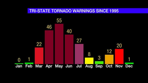
Wind shear – or the change in the direction or speed of the wind with increasing altitude – is often stronger in the colder months; this is mainly due to the jet stream – specifically in the polar jet stream – being stronger. Instability, however, is often limited during the colder months of the year; this tends to limit the number of severe storms. The secondary spike in Tornado Warnings late in the fall is a byproduct of instability and low-level moisture increasing ahead of stronger fronts.
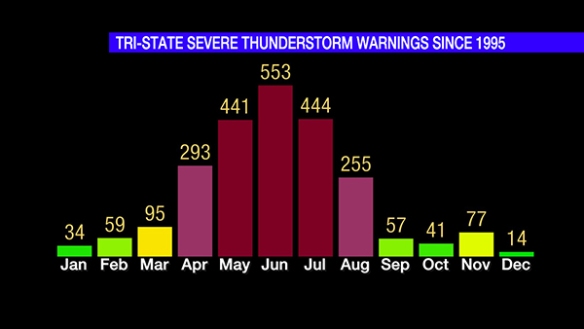
Severe Thunderstorm Warnings in the Tri-State are most common during the summer, when instability is highest and the potential for large hail and damaging straight-line winds is elevated. Note, however, that 118 Severe Thunderstorm Warnings have been issued during October and November:
The most common month for Flash Flood Warnings in the Tri-State is June with May and July being close for second and third, respectively. Unlike Tornado and Severe Thunderstorm Warnings, there is not a secondary spike in Flash Flood Warnings during the fall:
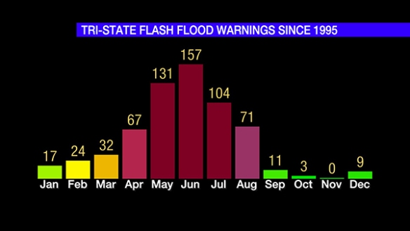
On average, September, October, and November are the first, fourth, and seventh driest months of the year, respectively. August is – on average – the 6th driest month. These numbers imply that soil moisture is often drier during the fall compared to the spring, summer, and winter. This usually – but not always – means that flash flooding is less likely to occur. Locally, the combination of melting snow and rainfall are the main reason for Flash Flood Warnings in the late winter and early spring.
While the most common month for Tornado Warnings in the Tri-State (since 1995) is May, April is the most common month for tornadoes (42 confirmed since 1950). The number of confirmed tornadoes drops dramatically from July to August, but – historically – tornadoes become slightly more likely from September to November:

Many of these late-year tornadoes are short-lived, weaker tornadoes in squall lines, but significant tornadoes (F2+ or EF2+ rating) have been recorded in the Ohio Valley during October and November. An F3 tornado killed 25 in the Evansville, Indiana area before sunrise on November 6, 2005.
I bring these statistics up as a marginal risk for severe storms has been posted by the Storm Prediction Center for the far eastern part of the Tri-State early Wednesday:

There is a very minimal risk for damaging straight-line wind and a brief tornado. This threat is very conditional on instability being able to develop and ahead of the front Wednesday morning. While the threat is small, the graphics on Tri-State warnings above should remind you that severe storms can and do occur long after summer’s end.