Perspective On An Unusually Quiet Severe Weather Season

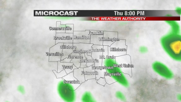
May is the second busiest month of the year for severe weather warnings. After a record number of tornadoes last year, this year – especially this month – has been anything but stormy.

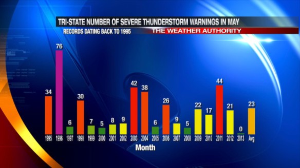
There have been no Severe Thunderstorm Warnings issued in the Tri-State so far this month. Compare that to the average of 23 warnings each May and the 76 warnings issued in the Tri-State in May 1996:

may24-svr

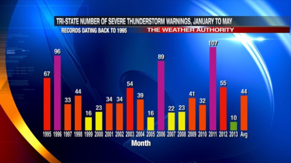
From January 1st to May 31st, an average of 44 Severe Thunderstorm Warnings are issued in southwestern Ohio, northern Kentucky, and southeastern Indiana. So far this year, only 10 Severe Thunderstorm Warnings have been issued in the Tri-State:

may24-svrjantomay

If no Severe Thunderstorm Warnings are issued for the rest of the month, the year-to-date number of Severe Thunderstorm Warnings will be at a record minimum (at least since the National Weather Service in Wilmington started issuing warnings for our area).

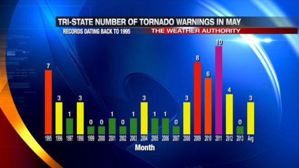
There have also been no Tornado Warnings issued in the Tri-State so far in May 2013; on average three Tornado Warnings are issued each May. Here’s the breakdown of how many Tornado Warnings have been issued each May since 1995:

may24-tor

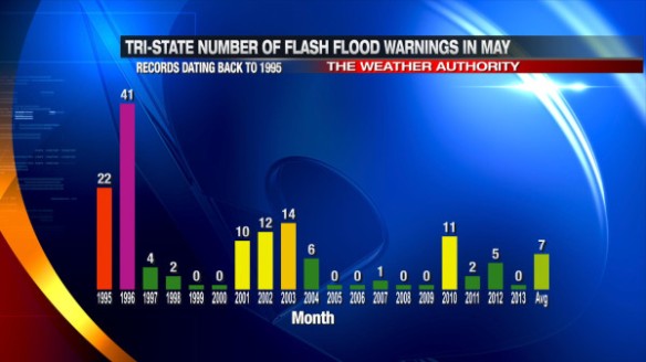
In addition to no Tornado and Severe Thunderstorm Warnings, no Flash Flood Warnings have been issued in the Tri-State. On average, 7 Flash Flood Warnings are issued in the Tri-State every May. Here’s how many year warnings have been issued each year during the month of May since 1995:

may24-ffw

Why have been there been so few Severe Thunderstorm, Tornado, and Flash Flood Warnings so far this year? You can’t place the blame on a single ingredient, but the lack of low-level moisture and cooler than average air for most of the spring are the biggest reasons.

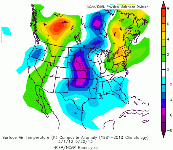
Data from NOAA’s ESRL shows colder than average temperatures (blue, purple) over most of the Midwest, Mississippi Valley, and Plains since March 1st:

may24-tanom

Warm air is a key ingredient for getting severe storms. While you need warm air near the ground to get strong storms, you also need cold air aloft. Data from NOAA’s ESRL shows that there has been plenty of that this season (in blue):

may24-500mbanom

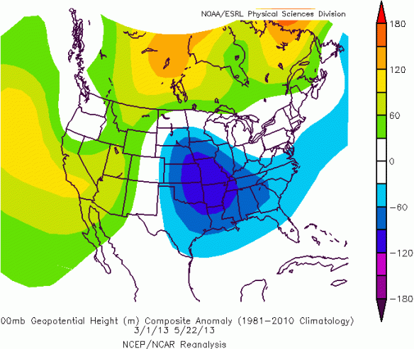
However, most of this cold air has been associated with upper-level lows and dips in the jet stream. Severe weather is not common when you have cold air aloft and little support at the surface.

NOAA’s ESRL data suggests there has also been a lack of instability this spring. One way to measure instability is by looking at a plot of Lifted Index:

may24-lianom

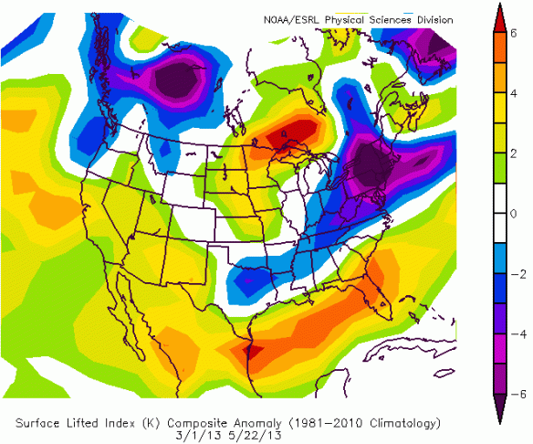
Higher Lifted Index values mean less instability and lower Lifted Index values mean more instability. Notice relatively unstable air (blue, purple colors) over the Ohio and Tennessee Valley compared to our northwest. In the last couple of months, the best instability has been to our southwest, south, and east. As a result, the strongest storms in this country so far this spring have been focused there.

A quiet start to the peak severe weather season doesn’t necessarily mean that we’ll see a quiet end of severe weather season. Be prepared for what could be a busy summer of severe weather!

Detailed Look At Late Week And This Weekend

A cold front will push through the Tri-State over the next couple of hours, bringing showers and thunderstorms to some but not all. Overall, late week looks quiet and cool.

This morning’s run of Microcast does a nice job with cloud cover and rain chances through through tomorrow. Microcast keeps the the best chance for scattered showers and thunderstorms southeast of Cincinnati at 8pm tonight:

may23-mc8pm

By midnight, we will likely still be mostly cloudy, but rain will be gone. Microcast has a good handle on this:

may23-mc12am

Clearing in earnest will begin just after midnight. By 7am, we’ll be clear, as Microcast shows:

may23-mc7am

If you love sunshine without the heat, tomorrow will be a nice day. Microcast shows a sunny to mostly sunny sky overhead for tomorrow’s afternoon rush at 5pm:

may23-mc5pm

It will be cool tonight, tomorrow, and into the start of the weekend. This morning’s WRF model suggest we’ll bottom out in the upper 30s and lower 40s Friday morning:

may23-6amtemps

I don’t think we’ll be quite that cold by 6am Friday. Most will drop into the low to mid 40s tomorrow morning,  10-15° below average.

This morning’s WRF model suggests we’ll reach to near 60° by lunchtime Friday:

may23-noontemps

High temperatures tomorrow will be in the mid 60s. This morning’s GFS model suggests we’ll be in the upper 60s (orange colors) by late Saturday afternoon:

may23-sathighs

We’ll likely reach into the upper 60s and lower 70s Sunday, and into the 80s nearing the middle part of next week. If your yard isn’t soggy, you’ll be able to mow tomorrow, Saturday, and most of Sunday:

may23-knowtomow

Mid-May Frost Perspective

Many saw frost in the Tri-State this morning thanks to a clear sky overhead, a calm wind, and a dry air mass in place. The warmest Tri-State locations only dropped into the lower 40s, but most hit the mid and upper 30s to begin Mother’s Day 2013:

may12-earlyamlows

Today’s official early morning low temperature of 37° at the Cincinnati/Northern Kentucky International Airport makes Mother’s Day 2013 the 6th coldest start to Mother’s Day on record (the first Mother’s Day was in 1908):

may12-coldmothersdays

Tonight looks to be colder than this morning with slightly drier air over the Tri-State and winds lighter for a longer period of time.

How unusual is it to see a frost or freeze in May? It’s unusual, but it happens every couple of years. Since 1871, Cincinnati has dropped to or below 32° 24 times, 34° 53 times, 36° 108 times, and 38° 185 times during the month of May (out of a total of 4,242 possible days). The latest spring hard freeze (28° or colder) on record in Cincinnati was in early May, but areas of frost have showed up in Cincinnati as late as May 31st:

may12-freezedates

Frost can occur at different temperatures; usually, a temperature of 36° or lower with a light wind means frost is a concern.

Nearly all of the temperatures we show you on television are measured about 6 feet above the ground. Because cold air is more dense than warm air (and therefore sinks), the temperature at the ground is often 2-4° colder than 6 feet above the ground. This is big reason why we are encouraging everyone to cover their plants or bring them inside overnight!

It is unusual to drop into the 20s in Cincinnati during the month of May. Since 1871, there have only been 2 hard freezes in Cincinnati between May 1st and May 31st. Here are some additional facts about near freezing temperatures in May:

may12-facts

The weather pattern from early May 2011 is very similar to the pattern we are in now. Note this morning’s low matches the morning low from May 4th, 2011 and tonight’s forecast low temperature matches the low temperature on May 5th, 2011.

I strongly recommend you bring in your plants tonight!

Timing Out Rain Chances This Week

An upper-level area of low pressure continues to spin over the Tennessee Valley at this hour, but it will slowly push east nearing mid-week. This upper-level low can clearly be seen as the swirl in 7:30pm water vapor satellite imagery (sampling moisture 15,000 to 30,000 feet above the ground):

may5-730wv

Ahead of this upper-level low is a large plume of low-level moisture, giving most in the Tri-State soaking rain now. Here are some 24-hour rainfall totals (8pm Saturday to 8pm Sunday) in the Tri-State:

may5-8pmtotals

The daily rainfall record for Cincinnati today (May 5th) has been already been broken. 1.72″ of rain fell through 8pm today at the Cincinnati/Northern Kentucky International Airport; the old daily precipitation record for this date was 1.67″, set in 1882.

Note many in the far northeastern part of the Tri-State have seen little or no rain, while some southwest of downtown Cincinnati have picked up more than 2″ of rain in the last day.

This morning’s Microcast run does a nice job with the timing of precipitation through Monday night. Microcast suggests light, moderate, and even some pockets of heavy rain will be around at midnight Monday:

may5-12ammon

Microcast suggests the coverage and intensity of rain will drop some overnight, but there will still be clusters of rain in the Tri-State at 8am Monday:

may5-8ammon

As temperatures rise through the 50s Monday morning, the coverage of rain will increase. Microcast suggests (and so do I!) you should plan for showers in and around your neighborhood at lunchtime tomorrow:

may5-12pmmon

Microcast still has rain in the Tri-State at 5pm tomorrow, but I don’t expect it to be as widespread in Cincinnati as it was this afternoon:

may5-5pmmon

Rain will be more scattered Monday night and Tuesday as this upper-level low slowly pushes east.

So when will the rain be done for a while? This morning’s GFS model suggests this upper-level area of low pressure (yellow, orange, and red colors) will to our southeast by early Tuesday morning:

may5-gfs8amtue

Energy rotating around that low pressure center (bright colors) will trigger scattered showers in our area Tuesday. By Thursday morning, the GFS model has this disturbance to our east:

may5-gfs8thu

All of the energy with that system will be focused to our east by then, so Wednesday and early Thursday look quiet. The GFS model, however, has more energy (yellow and orange colors) to our west by Friday morning, meaning chances for showers and thunderstorms will return late in the work week:

may5-gfs8amfri

Wednesday looks to be our only break from this active pattern this week! Longer-range forecast guidance suggests early next week will be quiet but cool.