Perspective On The First Snow Of The Fall/Winter In Cincinnati

Since summer ended, snowflakes have yet to fall in Cincinnati this season. Despite what you may may think, it is unusual to make it this far into the fall without at least flurries. In the last 100 years, there have only been 31 years where the first snowflakes of the fall or winter fell after November 16th (today’s date). Accumulating snow, however, does not usually occur in Cincinnati before November 16th; in the last 145 years, the first day with accumulating snowfall came before November 16th roughly 34% of the time (49 of those years).

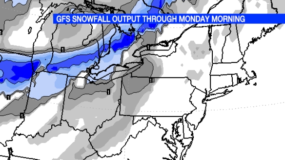
Some computer guidance suggests flurries will mix with rain this weekend. I am intentionally vague on the timing because this morning’s GFS model paints rain showers with some flurries Saturday morning and afternoon in the Ohio Valley, while this morning’s ECMWF model is suggests a better chance for flurries Saturday afternoon and evening. Notice the potential for accumulating snow of 1″+ for parts of the Great Lakes and northern Ohio Valley this weekend:

nov16-snowfall

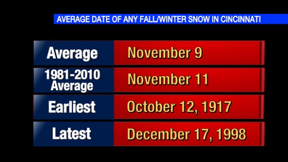
As I highlighted above, we are due for our first snowfall of the season. From 1915 through 2014, the first date of the fall or winter with ANY snow (whether it accumulated or not) is November 9th on average. The first flakes of the season have fallen as early as October 12th and as late as December 17th:

nov16-anysnow

Since 1870-1871, there has never been a winter without measurable snowfall or flurries in Cincinnati.

The first day with accumulating snow during the fall or winter in Cincinnati, on average, is in late November:

nov16-accumsnow

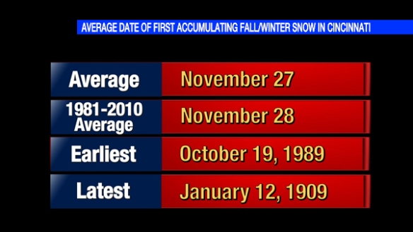
5″ of snow fell on October 19, 1989, the earliest day of the fall on record were accumulating snow occurred in Cincinnati. Meanwhile, the first day with accumulating snow during the winter of 1908-1909 came on January 12, 1909 (when 6.8″ was recorded). On average and based on records from 1870 through 2014, 1.3″ of snow accumulates on the first day of the fall or winter with accumulating snow.

On average, the first day of the fall or winter in Cincinnati with 1″ or more accumulating snowfall is December 15th. As you saw above, 5″ of snow fell as early as October 19, 1989 in the Queen City. The latest in the fall or winter where 1″+ of snowfall accumulated was March 5, 2015…just 3 days after the deadliest severe weather day in the Tri-State since official records began in 1950.

Everything You Need To Know About Tonight’s Severe Weather Threat

The risk for strong and severe storms is in play tonight, but this is a limited threat for severe weather. Much of the Tri-State is under a marginal risk for severe storms tonight according to the Storm Prediction Center:

nov11-3pmspc

The threat for severe storms will be higher along and west of I-75. Storms that sweep through the Tri-State tonight will be moving quickly, approximately 40-50mph from the west to the east.

Damaging straight-line wind is the main threat with the strongest storms tonight. The most likely time for severe weather to occur is between 11pm and 3am:

nov11-impacts

As I have mentioned for days, clusters of rain and storms will weaken as they approach the Tri-State from the west tonight. This morning’s computer forecast models suggest showers and storms will stay to our west through 7pm:

nov11-7pmradar

Clusters of rain and storms will move into the Tri-State late this evening and gradually most east of I-75 early in the overnight:

nov11-1amthursday

When you wake up and to head to work Thursday, showers will be widely scattered at best and focused east of Cincinnati:

nov11-7amthursday

Regardless of how strong storms are tonight, the wind will remain strong Thursday and Friday; wind tomorrow and Friday will be due to the strength of low pressure positioned to our northwest and not from storms. Here’s my latest thinking on wind speeds and wind directions through this weekend:

nov11-wind

While the threat for strong and severe storms is relatively low tonight, please stay alert for warnings. You are encourage to make sure your NOAA weather radio is programmed correctly and has fresh batteries this evening; fresh batteries will ensure that if your radio loses power from the A/C outlet, you will still be able to get warnings if you are sleeping.

An Update On Wednesday Night’s Severe Threat

The threat for severe storms is still very much in play Wednesday night for the Tri-State; however, that threat has dropped some in the last 24 hours.

The Storm Prediction Center has placed parts of southeastern Indiana and a small part of northern Kentucky in a marginal risk for severe storms Wednesday night:

nov10-spc

As of Monday night, nearly the entire Tri-State was in a slight to marginal risk for severe storms. The map above shows the risk for damaging storms has dropped, but strong storms and heavy rain still remain a possibility.

The threat for severe storms in the Tri-State will center between 10pm Wednesday and 3am Thursday. Damaging straight-line wind is the main threat, but it is not the only threat:

nov10-impacts

One computer forecast model shows a line or lines of rain and storms developing in the Mississippi Valley Wednesday night. Some discrete, rotating cells are possible over Missouri and Illinois tomorrow, as this model suggests:

nov10-7pmwednesday

This same computer model shows the line of rain and storms to our west early Wednesday evening weakening by the time they get close to Cincinnati:

nov10-1amthursday

While I expect the line of rain and storms to be better organized and less broken than this model suggests, there is a clear indication from the model that storms will weaken traveling east through the Ohio Valley Wednesday night.

One thing that has not changed is my thinking on wind following Wednesday night’s storms. The sustained wind Thursday and Friday in Cincinnati will be between 15 and 30mph with gusts up to 45mph possible:

nov10-wind

Winds will relax by this weekend. Please stay weather aware Wednesday night as storms move through the Tri-State. Even after storms pass, the wind will remain strong Thursday and Friday with a strong area of low pressure nearby.

What You Need To Know About Wednesday Night’s Severe Weather Threat

Wednesday night will be one of those times to be alert for thunderstorms and strong wind. Today is only Monday, so there is roughly 48 hours to adjust the forecast.

There is high confidence that the best threat for severe storms during this event will be to our west in the Mississippi Valley. The tornado, damaging straight-line wind, flooding, and hail threat all converge on Missouri, Illinois, western Kentucky, and northeast Arkansas. In the Ohio Valley the threat for severe weather will be maximized late Wednesday evening and in the very early morning hours of Thursday. Storms that develop to our west Wednesday afternoon will move east towards the Tri-State at 45 to 60mph; in simple terms, storms in the Ohio Valley Wednesday night will be fast movers.

There is moderate confidence that the threat for severe storms will gradually drop as storms that develop in the Mississippi Valley move east Wednesday night. Because there will be gradual decrease in the intensity of storms, severe storms remain a possibility in the Ohio Valley – especially west of I-75 – Wednesday night.

There is low confidence in the exact strength and timing of storms Wednesday night. While there is computer forecast model agreement at this time, models may give us adjustments on timing and how strong storms will be later this week.

Heavy rain and strong to severe wind are the main severe weather threats in the Tri-State Wednesday night:

nov9-impacts

Note the most likely time for strong or severe storms in the Tri-State is from mid-evening Wednesday into the early overnight Thursday. The tornado threat is non-zero, as is the threat for flooding. The hail threat is very low at this time.

The Storm Prediction Center has placed the Tri-State in a marginal to slight risk for storms Wednesday night, with the highest threat for severe storms being west of Cincinnati:

nov9-spc

With storms forecast to move from west to east Wednesday night, this map suggests storms will weaken as they sweep through the Tri-State.

The position of the jet stream is very important in severe weather forecasting this time of year. In the map below, the jet stream is in blue, and faster winds are in the dark blue color. Divergence aloft – in purple where air is rising – is centered to our northwest Wednesday night:

nov9-divergence

Because the best lift from the jet stream will be to our northwest, this will limit but not prevent the threat for strong storms. Note weaker divergence over Cincinnati Wednesday night, so at least some upper-level support is there.

Low-level shear – or the change of the speed and direction of the wind with increasing altitude – is also important for severe storm forecasts. Notice an abundance of speed shear over the Tri-State Wednesday night:

nov9-shear

More shear tends to support better organization to storms. In this case, there is plenty of speed shear but not a lot of directional shear; this suggests the tornado threat is limited, but damaging straight-line wind is a concern.

The wind about 5,000 feet above the ground Wednesday night will be very strong (about 80mph! in purple):

nov9-850wind

While not ALL of this wind will be transferred to the ground, this is a very strong wind. For the math buffs, these wind speeds are about 2 to 3 standard deviations above average. The threat storms will end Wednesday night, but strong wind is forecast Thursday and Friday (sustained between 15 and 30mph with higher gusts). Note the ribbon of strong wind focused to our north Thursday evening:

nov9-850wind2

Wind speeds will drop Saturday, and the wind will be light Sunday.

Be prepared for storms and strong wind Wednesday night! Even if storms don’t cause damage, winds may be strong enough to cause power outages.

What You Need To Know About Friday’s Severe Threat

As I mentioned in my last blog post, there is a secondary severe weather season in the Tri-State. There is often an increase in the number of tornadoes, Tornado Warnings, and Severe Thunderstorm Warnings during the fall as the jet stream strengthens and low-level moisture increases ahead of strong fronts. Late tonight and early Friday is one of these cooler-season opportunities to see strong to severe storms.

The risk for severe storms late Thursday and early Friday is low, but it should not be ignored. The Storm Prediction Center has placed the Tri-State in a marginal risk for severe storms early Friday:

nov5-svr

The threat for this severe weather with this system will be much higher to the west of the Tri-State this evening. Rain and storms to our west now, however, will move towards the Tri-State late tonight and exit the Ohio Valley Friday morning and early Friday afternoon.

Because instability is often limited this time of year, it is important to see where the jet stream will located when assessing the potential for severe weather. Friday morning’s NAM model – along with most computer models – have the jet stream (pictured below in blue) positioned to our north tomorrow morning, but in a part of the jet stream where lift is favored (highlighted with pink near Cincinnati, which is an orange dot):

nov5-7amjet

The strongest cells in the Tri-State may not produce lightning. Even clusters of rain Friday morning may produce strong or severe winds. While damaging straight-line wind is the main severe weather threat tomorrow, the tornado (weak and short-lived) threat is in play. Again, the overall threat for severe weather is LOW:

impacts

Notice that 4am to 11am Friday is the severe weather window. Future radar data suggest a line or lines of rain and storms will be materializing along and west of I-75 around 4am:

nov5-4amradar

Lines of rain and storms will be sweeping through the heart of the Tri-State nearing 7am. Notice models trying to create bowing segments in the Ohio Valley tomorrow morning; this suggests the possibility for damaging wind in the strongest cells:

nov5-7amradar

The threat for severe storms will decrease gradually Friday morning. Notice rain and storms gradually moving east of Cincinnati and weakening by 10am:

nov5-10amradar

As always, have your NOAA weather radio on and programmed correctly; you might check this before you go to bed tonight. Even if storms don’t become strong or severe, soaking rain and wet roads are likely for Friday morning’s commute.