Historical Perspective On This Morning’s Freeze

A freeze in the second half of May in Cincinnati is rare. While rare, freezes and frosts and do occur in late May.

The official low temperature this morning at the Cincinnati/Northern Kentucky International Airport was 31°. This sets a new record low temperature for May 16th; the previous record for May 16th was 32°, set in 1997. Low temperatures in the low to mid 30s were widespread this morning:

may16-lowt

Inside the I-275 loop, temperatures were slightly warmer due to the urban heat island effect (more building/concrete to retain heat):

may16-lowtm

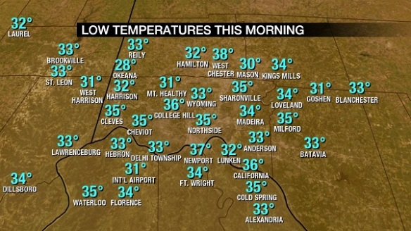
Notice Okeana dropped to 28°. Two weather stations just north of Lebanon reported low temperatures of 29° and 28°. Several sites reported a low of 30° or 31°.

How rare is a low temperature of 32° in mid or late May in Cincinnati? Here are the latest spring dates in the Queen City with a low temperature of or below 32°:

may16-latestfreeze

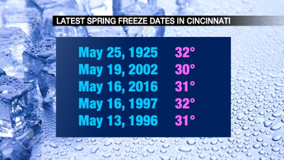
Notice that today’s low of 31° is the 3rd latest spring freeze date on record (back to 1871).

Frost can occur at various temperatures, but 36° or below is a good threshold to use for frost. Using 36° as a baseline, here are the latest spring frost dates in Cincinnati back to 1871:

may16-latestfrost

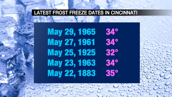
Today’s low of 31° ties as the 9th latest spring frost date in the Queen City. A freeze (which we had this morning) implies widespread frost.

I am cautiously optimistic that this morning will be the last freeze and frost of the season. There are no forecast overnight lows in the 30s through this weekend. Additionally, history suggests we’re safe from a freeze or frost once we get into June!

What You Need To Know About Today’s Severe Weather Threat

The Tri-State is in a slight to enhanced risk for severe storms this afternoon and evening. This is the highest threat for severe storms we’ve had so far in 2016.

The latest Storm Prediction Center outlook has the enhanced risk (the highest risk for severe storms over and southwest of Cincinnati this afternoon and evening; strong and severe storms are (slightly) less likely to the northeast and north of Cincinnati:

may9-noonspc

I encourage you to focus not on the severe threat category for which you live; instead, know that the threat for severe storms is higher in Cincinnati and points south and southwest of Cincinnati and slightly slower from Middletown to Hillsboro.

Based on radar, satellite, and model trends, it appears the highest threat for severe storms will be highest between 3pm and 10pm today:

may10-impacts

What might the radar look like at various times today? One model, the High-Resolution Rapid Refresh, seems to have a decent grasp on rain and storm placement now. Here’s what it suggests the radar will look like at 2pm today:

may10-2pmradar

Notice the round of showers and storms that came through late in the morning exiting the Tri-State completely (to the northeast) by 2pm.

Forecast radar at 5pm shows showers and storms becoming more numerous:

may10-5pmradar

Forecast radar at 8pm shows showers and storms bowing and gradually pushing east of Cincinnati:

may10-8pmradar

By 11pm, the High-Resolution Rapid Refresh model shows storms diminishing and pushing east of I-75:

may10-11pmradar

Be prepared! Some storms may produce damaging straight-line wind and large hail. The strongest storms in the Ohio Valley will be capable of producing flash flooding and tornadoes.