Accumulating Snow Coming, But Not Much

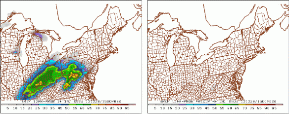
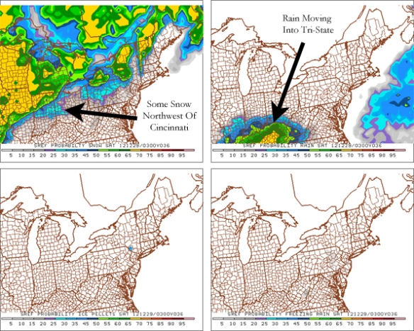
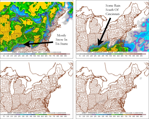
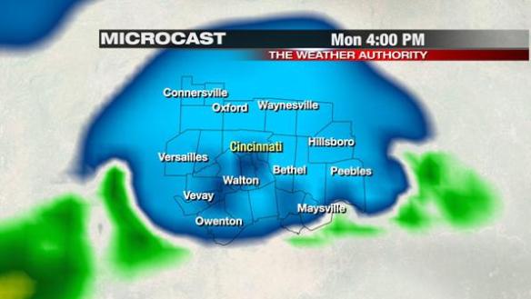
A rain/snow mix is likely by mid to late afternoon in the Tri-State as a cold front approaches from the west. Through late morning, the only nearby reports of rain or snow reaching the ground have been in southwestern Indiana and western Kentucky. Dry air near the ground is winning for now, but there will likely be some light rain and snow in the area by 4pm, as the latest run of Microcast shows (snow is in blue, rain is in green):

dec31-micro4pm

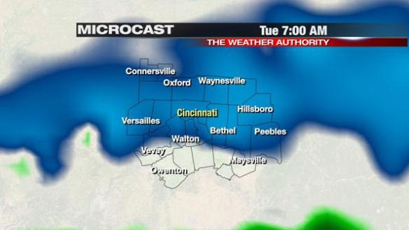
Temperatures will drop only a couple of degrees tonight. In Cincinnati, we should drop to 29° by early Tuesday morning…just cold enough for snow. Notice Microcast forecasting snow showers around 7am tomorrow:

dec31-micro7am

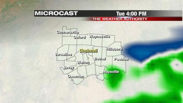
Snow will be diminishing tomorrow afternoon and may briefly mix with rain as temperatures crawl back into the low and mid 30s. Microcast paints a light rain/snow mix in the Ohio Valley at 4pm tomorrow:

dec31-micro4pmtues

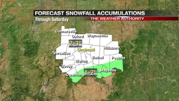
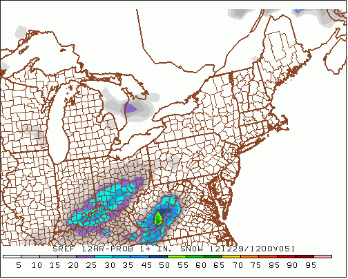
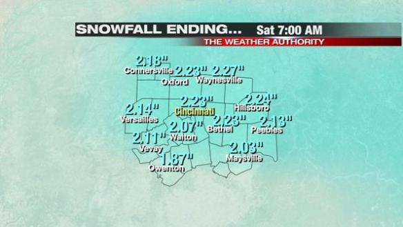
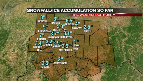
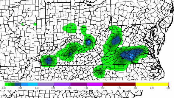
Microcast gives us about 1″ of storm total snowfall accumulation through tomorrow night, and last night’s hi-resolution ECMWF gives us about the same:

dec31-00zecmwfsnow

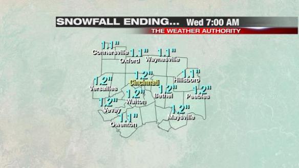
Other models – including the last two runs of the NAM and GFS – give us 1″ or less. Unless a big change happens in the models, you can plan on around 1″ or less for the entire event; isolated amounts more than 1″ are possible tomorrow, but no community is favored to see 1″+ over another.

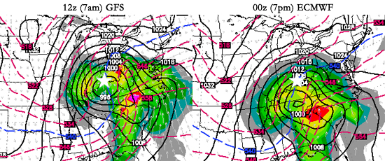
If the cold has been too much for you recently, think back to this summer when we had several days over 95° and a few over 100°. When you balance this year’s cold and warmth, the warmth clearly won out. 2012 will likely finish as the 4th warmest year on record in Cincinnati (records date back to 1871) and the warmest year on record at the Cincinnati/Northern Kentucky Airport (official records for Cincinnati began there in 1947). Here are the warmest years in Cincinnati:

dec31-warmestyears

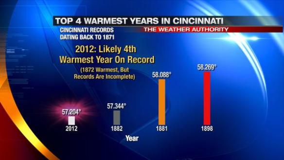
It is worth noting that Cincinnati records from 1870 to 1915 – including in 1881, 1882, and 1898 – were taken downtown at the first local National Weather Service forecast office. These records are likely skewed warm due to Cincinnati’s urban heat island. While it is difficult to confirm, 2012 would likely be the warmest year on record if Cincinnati’s records were taken in the same location since 1870 (unfortunately, this is not the case).

Happy New Year!

Big Snow For Tri-State Recently; More Snow, Some Rain Coming

From October 2011 to April 2012, 5.6″ of snow fell in Cincinnati. Contrast that with the 7.4″ of snow that has fallen in Cincinnati over the last 10 days. In Cincinnati, more snow has fallen in the last 10 days than in the 635 days before them (6.5″ fell between 3/27/2011 and 12/20/2012).

With Friday and Saturday’s event, there were large differences in storm total snow accumulations from one community to the other. Here is a map of storm reports from the National Weather Forecast Office in Wilmington (not all of the amounts shown are storm totals):

dec30-snowtotals

Notice the variation on snowfall amounts in and around the I-275 loop; I measured 1.9″ of new snow at the WKRC-TV studios in Mt. Auburn through 9:45am Saturday, but most within 10 miles saw 2-4″:

dec30-snowtotalsmetro

I assure you my total (through 9:45am) is correct; I am a trained weather spotter…and a meteorologist!

Unlike Wednesday’s event where there were fairly uniform bands of 1-2″, 2-4″, etc., snowfall amounts with Friday and Saturday’s event resembled a shotgun spray where some got blasted and others didn’t see as much. Snow banding was the main driver behind the variation in totals. Most of the fresh snowpack in the Ohio Valley can be seen on late morning visible satellite imagery:

dec30-satellite

Today will be sunny to mostly sunny with high temperatures in the upper 20s.

Another round of rain and snow is coming late Monday, Tuesday, and Tuesday night. The best chance for rain – be it small – will be favored south of Cincinnati tomorrow afternoon and evening. Most will just see snow from late tomorrow afternoon through Tuesday night.

How much snow is coming? Odds of 1″+ of snow from Monday afternoon through Tuesday night look good. Totals beyond that are uncertain. The latest NAM model runs paints 1-2″ of snow for the entire event, the latest GFS paints about 1″ (some community with less), and last night’s ECMWF model run paints 1-2″ of snow for most. This is raw model output, not a forecast. Forecast totals may be released as soon as tonight.

Rain & Snow Coming Tonight, Accumulating Snow Likely By Saturday Morning

Yesterday afternoon, models suggested 1-2″ of snow would accumulate in the Tri-State tonight through Saturday afternoon. The newest model data is more aggressive with the chance for snow, so forecast snow amounts have gone up.

Recent SREF model runs have shifted heavier snowfall amounts north overnight, and have also increased totals. The risk for 1″+  of snow from 10pm to 10pm tonight is on the left; the 4″+ chance is on the right:

dec28-15zsaturday

Notice a rather high chance for 1″+ in and around Cincinnati in this time period, but a low chance for 4″+. This is the main reason why I am not including 4″+ totals in my forecast for now. An isolated 3.5″ to 4″ amount is possible in our area, but it is not likely at this point.

The latest high-resolution ECMWF model shows generally 2-3″ of snow in the greater Cincinnati area tonight through tomorrow night:

dec28-12zecmwf

These totals look realistic with the exception of the far southern Tri-State, where most models have lower snow amounts.

The National Weather Service has issued a Winter Weather Advisory for all but Mason County, Kentucky from 7pm tonight through 1pm tomorrow:

dec28-wwa

My latest snow forecast calls for 2-3″ for most in the Tri-State tonight through tomorrow afternoon; 1-2″ totals will be confined to parts of Owen, Mason, Robertson, Grant, Bracken, Adams, Brown, and Pendleton County:

dec28-5amsnowfall

Forecast totals will likely change later today; look for updates this afternoon and evening!

Another Round Of Snow Coming Soon

It will be cloudy tonight, but no rain, sleet, freezing rain, or snow is forecast until late tomorrow afternoon at the earliest. The latest model guidance continues to have accumulating in the Tri-State this weekend, but this will be a much weaker disturbance than the one that come through Wednesday.

Because this disturbance will be much weaker, snowfall totals will likely be much lower. Before we see accumulating snow, there will be a mix of light rain and snow Friday evening. The latest SREF model shows this mix of rain and snow around 10pm Friday; notice the rain winning out tomorrow evening:

dec27-03zsat

By 7am Saturday, however, the SREF model shows mostly snow in the Cincinnati area:

dec27-12zsat

This is likely going to be accumulating snow with temperatures in the upper 20s and lower 30s early Saturday morning. How much? The SREF has a 30-50% chance in the Tri-State (depending on where you live) for 1″+ of snow between 7pm Friday and 7am Sunday:

dec27-12satsnowchance

While this is NOT a forecast, the 7am run of high-resolution ECMWF model is rather aggressive with the threat of accumulating snow Friday night and Saturday:

dec27-12zecmwf

Again, this is raw model data and not a forecast. These numbers appear to be a bit high, but isolated amounts up to 1.5-2″ appear possible with this system. These numbers are preliminary; adjustments are likely in the next 24-36 hours. I would rather ramp totals up than ramp them down. There will likely be some variations in snowfall totals from one Tri-State community to another.

We will release a snowfall forecast in the next 24 hours…stay tuned.

December 26th Winter Storm Verification & Reflection

The biggest storm of the 2012-2013 winter season so far is behind us. Official records for Cincinnati are taken at the Cincinnati/Northern Kentucky International Airport; 2.9″ inches of snow fell at the airport, making today the snowiest single day since January 20, 2011 (707 days ago) when 5.6″ of snow fell. As promised Monday and Tuesday, there would be a wide range of snow and ice amounts in the Tri-State, and there were. Here’s a map of selected snow and ice accumulations (all that can fit on the map) in southwestern Ohio, northern Kentucky, and southeastern Indiana through 9pm:

dec27-verif

There were some late storm totals:
Blanchester: 2.5 snow, 0.1″ of freezing rain accumulation
5 miles west of Cornith, Kentucky: 0.3″ snow accumulation
3 miles east of Cheviot, Ohio: 3.3″ snow accumulation

This is the objective analysis from NWS Wilmington as of Thursday morning. This report includes reports collected yesterday and reports from spotters that regularly call into the NWS each morning:

dec27-nwstotals

So how accurate was the forecast from Tuesday night? Here’s what I had on the air at 11pm Christmas night:

dec27-forecast

Only very subtle changes were made to John Gumm’s forecast at noon Christmas Day for the 4pm-11pm newscasts. More than 24 hours out, John had nearly every town in a correct snow and ice accumulation snow total band. What an outstanding forecast! After afternoon and morning model runs, I made very few changes to his forecast (the biggest being the extension of the 6-10″ band into northern Ripley County and central Franklin County). The title on this graphic should read “snowfall and ice” instead of just snow, but most saw 0.1″ of freezing rain accumulation or less. Brookville is the outlier on the map, but totals around Brookville ranged from 6″ to 9″ Wednesday afternoon. Considering there was blowing and drifting snow along with freezing rain and rain mixing in along and south of I-71, the forecast worked out quite well. Forecasts like these don’t always work out this well, but I’m thankful this one did.

On Monday night, snow and ice amounts did not look like they did Tuesday. I did not release snow and ice amounts Monday night. While some may have been wondering “where is the snow forecast?” it was the right decision to wait until there was some agreement among the models.

On a personal note, the hardest part of the day was hearing this story: http://www.local12.com/news/local/story/One-Person-Dead-After-Crash-on-I-71/C9HaT52MzkapO7aJEUQyLQ.cspx

While it is sad to hear of a crash that was most likely weather related, it was even harder to see this knowing that I highlighted the blizzard – or at bare minimum “blizzard-like” – conditions in this area as a band of heavy snow came through on-air. This is what the Buckeye Traffic camera looked like at the intersection of I-71 and Fields Ertel Road around 4:40pm Wednesday:

dec27-fields

Roads were mostly snow covered, and the visibility was significantly reduced due to blowing snow. I told people on the air Wednesday to not drive in this area (and other areas with blowing snow) if they didn’t have to or until the band of snow had moved out of the area. Unfortunately, an 18-year-old woman lost her life Wednesday along this road, and this upsets me. It is hard to reach people in their cars, but I wish I could have.

On a lighter note, I want to thank all of our spotters that gave us snow and ice reports through the morning, afternoon, and night Wednesday. This job is much easier with your support and help!

Winter Storm Coming, Blizzard Conditions For Some

A large winter storm is on the way to the Ohio Valley later tonight and tomorrow. Like many storms in the Ohio Valley (especially where rain and ice mix in), snowfall totals are going to be tricky. There is fairly high confidence that the heaviest snowfall totals are going to be focused north and west of Cincinnati. Lower totals (where light freezing rain and rain will be found much of tonight and tomorrow) will be along and south of I-71. There is still great uncertainty in snowfall amounts along I-71. Some counties may see a 3-6″ spread from the highest snowfall total to the lowest total in the county.

A Blizzard WARNING is in effect from 1am tonight through 1am Thursday for Fayette, Union, Franklin, Butler, and Ripley County. Many in this area can expect frequent gusts up to 35-40mph, blowing and drifting snow, and visibilities under 1/4 due to blowing and drifting snow late tonight and Wednesday:

dec25-blizzardwarn

A Blizzard Warning does not mean 2′ of snow; it is issued when a combination of winds and low visibility make it difficult to travel. I strong discourage travel in this warned area late tonight and tomorrow. Sustained blizzard or blizzard-like conditions are not expected at this time in the Cincinnati metro.

A Winter Storm WARNING is in effect from 1am tonight through 1am Thursday for Warren and Clinton County. These areas are likely to see gusty winds, bursts of heavy snow, and wind chills in the mid teens to lower 20s overnight and tomorrow. 4-6″ of snowfall accumulation (with isolated higher amounts) are forecast in the northern half of the warned area:

dec25-wsw

Lower snow amounts are forecast closer to the Ohio River, where a Winter Weather Advisory is in effect from 1am tonight through 1am Thursday:

dec25-wwa

Notice there are areas south of this advisory not under any sort of alert. Only 1″ or less of snow is forecast in these areas, mainly due to the amount of freezing rain and rain mixing with snow. In fact, sections of northern Kentucky may see rain for most of the night and Wednesday before changing over to snow.

The most severe winter weather will be northwest of Cincinnati tonight through tomorrow night. Less snow and lighter winds will be found along and south of I-71, especially from Owenton to West Union.

For now, here is what I expect for snowfall amounts:

dec25-snowfall4pm

Notice the differences in snow totals, especially in counties along I-71. If this forecast verifies, northwestern Hamilton County will see 4-6″ (with isolated higher amounts) and southeastern Hamilton County will see 1-2″. These forecast snowfall amounts may change later tonight and tomorrow, and there may be isolated higher or lower amounts outside of each snow band.

Do you need any outline of when things are going to happen? There’s a lot to take in; I understand! Expect snow northwest of Cincinnati, rain and freezing rain southeast of Cincinnati, and a mix of rain, snow, and freezing rain along I-71 and in Cincinnati to change over to mostly snow by late tomorrow afternoon. Even at 4pm tomorrow, there will still be many with little or no snow accumulation (and just rain and/or flurries) well southeast of downtown:

dec25-whattoexpect

Stay tuned; we will update the forecast as needed!

Winter Storm Likely Wednesday

Computer models continue to suggest a large winter storm will soon develop in the Ohio Valley. Outside of very light drizzle or mist tonight, no precipitation is expected until Tuesday evening at the earliest. Near and after midnight Wednesday, rain and snow will overspread the Tri-State. Most northwest of Cincinnati will see all snow (or little rain) very early Wednesday morning, but the rest of the Tri-State will see a mix of snow and rain. Through Wednesday morning and afternoon, cold air will wrap in behind low pressure, and accumulating snow will overspread southwestern Ohio, northern Kentucky, and the rest of southeastern Indiana.

Based on recent model trends, the threat for seeing a winter storm in the Tri-State has gone up slightly:

dec24-stormrisk3

The SREF model (which is really a blend of models) suggest 1″+ is likely for much of the Tri-State between 4am and 4pm Wednesday. It also suggests significant chances for 4″+ and even 8″+ of snow in central Indiana, including the northwestern part of the Tri-State:

dec24-21zwednesday

Just after 4pm this afternoon, the National Weather Service in Wilmington issued a Winter Storm WATCH for Fayette, Union, Franklin, Butler, and Warren County:

dec24-winterstormwatch

This watch is in effect from 1am Wednesday to 1am Thursday. This watch may be expanded or Winter Storm Warnings and/or Winter Weather Advisories may be issued in the next 24 hours. Travel will be difficult at times Wednesday, especially during the afternoon and evening.

There is still great uncertainty on the exact timing, strength, and positioning of this system. The forecast will likely change as new model data comes in and once the storm forms.

There will likely be a WIDE spread in totals from Connersville to Maysville. Some models have a spread of over 12″ of snow between these two cities. This will be an abnormally difficult forecast, and it will be very difficult to pin down snowfall amounts for any given location especially with blowing snow.

Thank you for your patience while we continue to make an accurate forecast. Stay tuned…

Uncertainties In Mid-Week Winter Storm

A winter storm is still forecast to affect the Ohio, Tennessee, and Mississippi Valley Tuesday through Thursday, but there are large discrepancies on the exact timing, positioning, and strength of this system. This is not unusual this far out. We are entering a time period where longer range models will wobble from one solution to the next and shorter range models are just now getting up to speed on where this area of low pressure will go.

In the shorter term, there is fairly high confidence that light rain and freezing rain will develop in the Tri-State tonight. The latest SREF model run shows rain for most at 1am tonight and the potential for freezing rain north of the Ohio River:

dec23-6zmonday

As temperatures go above freezing tomorrow morning and afternoon, the threat for freezing rain will diminish. Rain, however, will begin mixing with freezing rain and snow Monday evening and early Tuesday. Notice the latest SREF model showing a blend of freezing rain, rain, and snow by 7am Tuesday morning:

dec23-12ztuesday

While there is no strong agreement in the latest round of model data on the potential for ice accumulation Monday night and early Tuesday, this signal from the SREF model is telling. While few will be going to work Christmas Day, the threat for ice accumulation Monday night and Tuesday morning needs to be watched carefully.

The strong model agreement regarding accumulating snow Tuesday night through Thursday is not as strong today. Both the early morning GFS and NAM model give the Cincinnati area little to no snow, but the ECMWF model remains consistent with it’s solution of heavy snow for much of Ohio, Kentucky, and Indiana. The latest outlook from NOAA’s Hydrometeorological Prediction Center shows the potential for 4″+ of snow from 7am Tuesday to 7am Wednesday west of Cincinnati:

dec23-hpc

Given the uncertainty in the latest model runs, no snowfall amounts will be released today, and totals and may not be released tomorrow. Releasing forecast snowfall totals too early just leads to empty promises; I would rather wait and issue a forecast with confidence than release it too early and mislead people.

Threat For Winter Storm Increasing

Confidence is increasing that a significant winter storm will affect the Ohio Valley Tuesday through Thursday. Heavy snow will be possible with this system. Recent model runs suggest the highest snowfall totals will be northwest of Cincinnati and lower amounts will be found southeast. For now, here’s my thinking on the winter storm threat from Tuesday night through early Thursday:

dec22-stormthreat

While the confidence for snow is increasing, there will likely be a a wide range on snowfall amounts in the Cincinnati area Tuesday through Thursday. The latest model runs suggest areas northwest of Cincinnati (especially north and west of the Tri-State over southern, central, and northern Indiana) may see several inches of snow, while areas southeast of Cincinnati will see considerably less.

There is also a potential for ice accumulation with this system, especially Tuesday night and early Wednesday. The newest SREF model probabilities (from 10am this morning) also suggest a rain/freezing rain mix at 7am Monday morning, with the highest chance for seeing ice along I-70 from Indianapolis to Columbus:

dec22-sref12zmonday2

While the area of low pressure set to move through the Ohio Valley will be strong, winds will not be as strong with this system as they were over the last couple of days. The latest model guidance for Cincinnati has 10-25mph sustained winds Tuesday through Wednesday night and wind gusts up to 45mph Wednesday and Wednesday night:

dec22-winds

It is still too soon to make a call on ice or snowfall accumulations with this Tuesday, Wednesday, and Thursday storm. More specifics will be released in the coming days…

Rain, Ice, And Snow Chances In The Week Ahead

Good afternoon! The flow off of Lake Michigan has been interrupted early this morning; this means early morning clouds are giving way to sun. While today will be quite sunny, high temperatures will only be in the low to mid 30s.

High pressure will relinquish control to low pressure Sunday. Clouds will overspread the Tri-State, and precipitation will begin developing in the afternoon. Precipitation will begin as rain Sunday afternoon and evening. The most recent SREF model run from this morning shows rain our area at 7pm Sunday night with the threat for freezing rain staying north of I-70:

dec22-sref00zmonday

With temperatures slowly falling through the 30s, freezing rain starts to become a possibility – especially north of Cincinnati – after midnight Monday. The latest SREF model run suggests rain is more likely south of the Ohio River at 7am Monday, while many north of Cincinnati will see ice mixing with rain:

dec22-sref12zmonday

Last night’s NAM model run is not impressed with the chance for ice accumulation north of Cincinnati early Monday morning, but last night’s GFS model run is. Note the potential for about a 0.1″ of ice in the northern Tri-State through 10am Monday morning:

dec22-fzra15zmonday

Both rain and ice will be light Sunday afternoon through early Monday. An ice storm or heavy rain is not expected at this time. Even small amounts of ice, however, can lead to very slick roads and sidewalks.

This disturbance coming through early in the week will be weak, but it will help a second, larger disturbance form and move into the Ohio Valley Tuesday, Wednesday, and Thursday.

There are still some big positioning differences in the model data regarding this system. Note that this morning’s GFS model run has the center of low pressure over the Tri-State at 7am Wednesday morning, while last night’s ECMWF model run has the area of low pressure over Tennessee (Cincinnati is indicated as a white star):

dec22-gfsecmwf

Differences in the positioning of the system make a tremendous difference in what type of precipitation we will see, how heavy that precipitation we will be, and when we’ll see precipitation. A more southerly track tends to mean more snow for the Ohio Valley, but there’s more to it than that.

Last night’s GFS model run suggests more freezing rain Tuesday night and early Wednesday; a map of how much ice will accumulate according to the GFS from now through 7am Wednesday is attached:

dec22-fzra12zwed

While the exact placement of ice accumulation will likely change over the next few days,  it is worth noting accumulating ice will be a concern Tuesday night and Wednesday.

The most recent runs of the GFS and ECMWF models suggest accumulating snow is likely Wednesday and Thursday. Specific totals are unlikely to be released this weekend; we’ll have a better handle on amounts Monday and Tuesday.

Confidence is rising that a significant weather weather event – including snow, rain, and freezing rain – will unfold Tuesday, Wednesday, and Thursday in the Tri-State. Stay tuned!