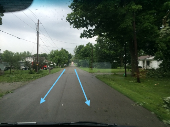
It’s not often I get to go out and survey storm damage. I’m usually in a studio under bright lights. When storms hit today, the newsroom dispatched me into the field. Initially, I saw tree damage along Pausch Road near Leesburg, Ohio:

This photo was taken looking northeast and all of the downed trees are pointing towards the southeast, where radar suggested the winds from the storm were pointing to. In nearly the same spot and facing the opposite direction, damage to barns suggested a northwest wind when it occurred. There was siding in the field from the leftmost barn pictures just southeast of the barn:

With all of the damage fanned out in a uniform direction, this suggested straight-line winds caused this damage.
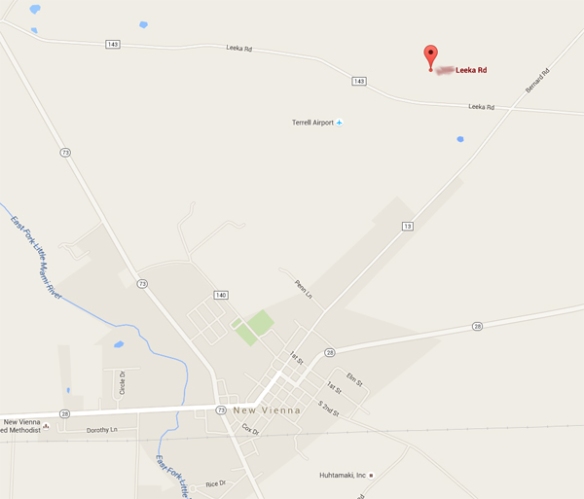
Shortly after we left the scene to head home, the newsroom directed us to a damaged home north of New Vienna, Ohio. Here’s the approximate location of the house relative to New Vienna:
Imagine what I felt arriving the scene and seeing this:
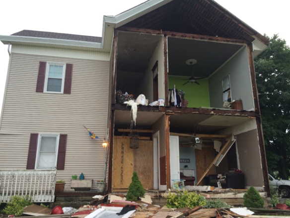
Whoa. What could cause this? I immediately went into investigation mode. Here’s a wide shot of this house and the yard around it:

Notice anything, even that this resolution? Most of the debris is to the left of the house. With this photo looking southeast, most of the debris is on the east or southeast side of the house, including all of this debris along the road:
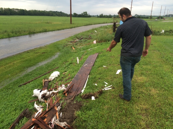
Closer to the home, I found this wood board driven into the ground:

Whoa. That’s some force. The home owner (pictured above) is actually an electrical engineer at General Electric. He was thinking like I was; he wondered how there could be all of this debris so far away from the house, especially east of the house. The wind was coming from the northwest at the time; if damaging straight-line wind was the cause of this damage, why was there so much damage to the east of the house (including large, heavy parts of the walls)? In addition to the debris field, that board driven into the ground suggested to me this was a tornado.
After we shot our video at the house, we drove through New Vienna (north on State Route 73); there was a lot of tree damage there:

I did not see any structural damage, and all of the tree damage seemed to lean towards the south, east or southeast. The alignment of buildings and tree along the road reminded me of the Venturi Effect, possibly explaining how winds were accelerating through the town. More on the Venturi Effect is here: http://www.tech-faq.com/venturi-effect.html. In other words, winds – moving northwest to southeast through the town, or basically down S.R. 73 – were accelerating or at least traveling through the town like this:
This damage appears to be caused by straight-line winds. As I drove home, I had a visual of what the radar data might look like. While I had looked at radar briefly in real-time as the storm moved through Highland County, I had not looked at the radar data in detail.
Here is the radar loop from 3:04 to 3:49pm for this Highland County storm:
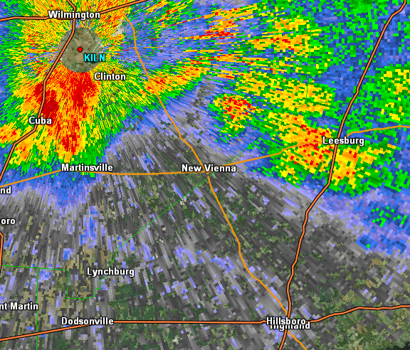
Here is the storm relative velocity (the Doppler part of Doppler radar or how the winds are moving relative to the radar [minus the motion of the storm to see rotation] in Wilmington, Ohio) loop of this storm from 3:04pm to 3:49pm:

From the radar’s lowest scan angle, red colors are winds moving away from the radar, green colors are winds moving towards the radar, and yellow colors are severe winds moving away from the radar. So the overall wind flow relative to the radar looked like this:
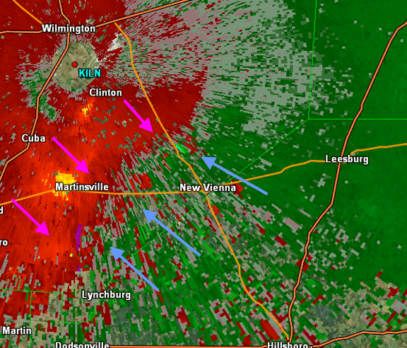
There’s no strong rotation here. Radar suggests mainly outflow winds. But there’s more! Let’s look specifically at the radar snapshot around 3:15pm:
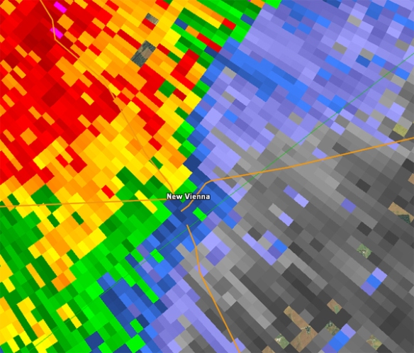
There’s no hook echo or strong inflow notch. Let’s look at the base velocity data for the same area:

Winds were moving away from the radar near New Vienna at the time damage occurred. Normally, strong winds towards and strong winds away from the radar are close together near a tornado. So there’s no tornado right? Not so fast. The magnitude of the wind speeds near New Vienna matter:

See how wind speeds over New Vienna are stronger than where the blue arrow is? Imagine a pinwheel facing the sky just north of New Vienna. Which way would it rotate? Counter-clockwise…like most tornadoes do. If you’re having a tough time visualizing this, see what normalized rotation looked like:

The green area shows significant counter-clockwise rotation based on raar; in other words, this is where radar is detecting rotation and the possibility of a tornado.
The National Weather Service in Wilmington is responsible for determining if damage was from straight-line wind or a tornado. I don’t know if they will survey this Saturday. Based on the damage I saw, the Leesburg damage looks to be from straight-line wind, but the New Vienna damage is more complicated. After seeing it with my own two eyes, the damage north of New Vienna looks tornadic, but the damage in town is a close call.
We will see what the verdict is from the NWS!