When Is A Warm-Up Coming?

Meteorological spring began on March 1st, but astronomical spring begins Wednesday morning at 7:02am eastern time. Despite what the calendar shows, it won’t feel like spring tomorrow or any day in the near future.

The colder-than average stretch we’ve been on for a couple of weeks is likely to last at least two weeks more.

NOAA’s Climate Prediction Center issued a forecast Febuary 28th suggesting that there was an equal chance of a warmer or colder than average March. This forecast is unlikely to verify:

mar19-cpcforecast

The last several days of March will likely be colder than average based on the latest guidance. This morning’s GFS model run suggests temperatures will be well below average (blue and green colors) Thursday morning over much of the nation:

mar19-2mta12zthurgfs

The latest ECMWF ensemble model also suggests below average temperatures (blue and purple colors) for most of the nation early Thursday morning, including in the Tri-State:

mar19-2mta12zthurec

If we fast-forward to next Wednesday morning, it’s more of the same. This morning’s GFS model suggest temperatures will be colder than average (blue, green, and purple colors) for the eastern two-thirds of the nation:

mar19-2mta12zwedgfs

The latest ECWMF ensemble model agrees with the GFS model regarding below average temperatures (blue and purple colors) next Wednesday morning:

mar19-2mta12zwedec

Based on this model data, it seems unlikely that a significant warm-up anytime in late March. This morning’s GFS, however, suggests a ridge of warmth may be building into the heart of the nation during the last week of March:

mar19-500anom12zmar30

This is a promising sign for those of you looking for a warm up. The strength and positioning of this ridge, however, is very uncertain; in turn, there is no guarantee that a warm-up is coming in early April.

In summary, it is too early to speculate on when a warm-up is coming. Confidence is fairly high, however, that the rest of March and at least a few days in early April will be colder than average.

From Snow To Thunderstorms: Things To Watch In The Week Ahead

The active weather pattern we have been stuck in for the last several days will not be going away anytime soon. Several disturbances are forecast to move through the Ohio Valley between now and next weekend. Some will be weak, while others will have punch. Some disturbances have little uncertainty surrounding them, while others are very uncertain.

While much of the evening will just be cloudy to mostly cloudy, showers and isolated thunderstorms will develop nearing midnight. A rapidly developing area of low pressure approaching from the west tonight will likely spark clusters of showers and thunderstorms later tonight. This morning’s WRF model has rain and thunderstorms in our area by 2am Saturday:

mar15-radar2amsat

Given the amount of cold air aloft, small hail and brief gusty winds will be possible with any thunderstorms that form. Confidence is high that showers and thunderstorms will diminish Saturday morning, and much of Saturday will be cloudy to mostly cloudy. Precipitation, however, is likely to return by 8am Sunday morning, as this morning’s WRF model shows:

mar15-radar7amsun

If you look closely, the model has the 32° isotherm/line in our area when precipitation is falling. With temperatures at and above the ground near freezing early, snow may mix in with rain in the morning. By afternoon, we will have just rain in our area with temperatures approaching 40°. This morning’s WRF model has rain in our area Sunday evening as well:

mar15-radar8pmsun

Greater uncertainty in the forecast comes for Monday as yet another area of low pressure sweeps across the Plains. Given modest instability, there will be a risk for thunderstorms Monday morning, afternoon, and night. There is still some uncertainty on how strong thunderstorms will be Monday and Monday night. The Short Range Ensemble Model suggests the best instability in our area will be in the early afternoon and focused over northern Kentucky:

mar15-cape18zmon

Given modest instability coupled with the strength and positioning of low-level moisture, upper-level energy, and wind shear, the Storm Prediction Center has placed sections of the Ohio and Tennessee Valley under a risk for severe storms Monday morning, afternoon, and night:

mar15-svrmonday

Two weaker disturbance passing through the Tri-State will give us a chance for flurries Tuesday and Wednesday morning.

More energy will move in late next week, bringing rain and perhaps snow showers to the Ohio Valley later next week. The timing and strength of this system is very uncertain.

Long Range Models Suggest Cold Wins Out For A While

New long range data has come into the weather center over the last week, and it looks like any warm-ups for the rest of March will be short-lived.

This morning’s GFS model is very similar to the last several runs before it, keeping colder than average temperatures around through the weekend, next week, and the week after next. While there will be some warmth into the start of this weekend, this morning’s GFS model has colder than average air (purple and blue colors) over much of the Midwest and Ohio Valley by next Tuesday:

mar13-gfstue

The GFS model also suggests that cold air sticks around into late March, including for Monday, March 25th:

mar13-gfsmon

Northwest flow and a persistent snowpack in southern Canada means reenforcing shots of cold air will keep coming for the second half of March.

A new ECMWF Weekly model run came in this afternoon. Like the GFS, it suggests below average temperatures will dominate for late March and early April. This afternoon’s ECMWF Weekly model says temperatures will be below average (blue colors) from this past Tuesday through next Monday:

mar14-ec1

The model also says temperatures will be below average in the Ohio Valley from next Monday through March 25th:

mar14-ec2

…and from March 26th from April 1st:

mar14-ec3

…and from April 2nd to April 8th (although not as cold as previous weeks):

mar14-ec4

The theme is clear: cold air will be a clear winner over warmth for the next few months. It is still too soon to make an outlook on the summer.

Thoughts On Snow Accumulation Tonight And Wednesday

We may be nearing mid-March, but we aren’t done with the threat of accumulating snow in the Tri-State. While the disturbance coming through late tonight and early tomorrow isn’t particularly strong, it will be strong enough to create snow showers and flurries around and after midnight.

Recent model runs have hinted at the possibility for localized bursts of snow for a few days now. Once of our in-house models, Microcast, has been very consistent with the timing and strength of this incoming disturbance. By midnight tonight, Microcast paints snow showers and flurries in and around the Tri-State (in blue):

mar12-12ammc

Microcast is also painting some shades of purple and pink, suggesting rain will mix with flurries. While this is possible, it is not likely given the forecast temperature profile of the atmosphere.

By 7am Wednesday morning, Microcast has several clusters of snow showers and flurries in the area:

mar12-7ammc

The ground and air near the ground will be cold enough to support a chance for accumulating snow at this time. With the morning commute in progress, slick or partially snow-covered roads, sidewalks, and driveways are a concern. Many will just see flurries and little to no accumulation while others that see snow showers may see 1/2″ to 1″ of snow by early Wednesday afternoon.

The risk for snow showers and flurries will drop dramatically by Wednesday afternoon. The latest run of Microcast has only widely scattered snow showers and flurries in our area by 5pm Wednesday:

mar12-5pmmc

This morning’s Microcast run gives nearly all of the Tri-State 1/10″ of snow accumulation or less through Wednesday afternoon:

mar12-adonis

While I agree with this model output overall, isolated 1/2″ to 1″ totals can’t be ruled out overnight and tomorrow morning in the heavier bursts of snow. The best chance for these isolated higher totals will be on elevated, grassy surfaces; accumulation on roads, however, is also possible in the next 24 hours.

Please use caution on area roads during Wednesday morning’s commute!

Update On Accumulating Snow Threat Tuesday Night And Early Wednesday

A Winter Storm WARNING has been posted for Fayette, Union, Franklin, Butler, Warren, and Clinton County from late Tuesday morning through 1pm Wednesday:

mar4-wsw

The rest of the Tri-State will be under a Winter Weather Advisory from 6pm Tuesday to 1pm Wednesday:

mar4-wwa

Light rain (especially after midnight) will mix with flurries tonight, and Tuesday’s forecast calls for mainly rain with some flurries in the morning. With ground temperatures at or above freezing tonight, accumulating snow is not a concern; accumulating snow, however, is likely late Tuesday night and early Wednesday.

For being this close to the Tuesday night/early Wednesday event, there is still great uncertainty about where the heaviest snow will fall in the Ohio Valley. The latest model data have trended farther south with the axis of heavier snow. Last night, it appeared the heaviest snow would be in northern Ohio and Indiana; that axis of heavier snow now looks to set up closer to I-70.

I will show you the latest model runs not to highlight specific amounts but instead to show you model uncertainties and where the heaviest snow – at least for now – will fall. Remember, this is NOT a forecast!

Our in-house model Precisioncast gives a wide range on totals from north to south; it suggests the southern-most communities in the Tri-State will see minor accumulations while many north of the Ohio River see at least a couple of inches of snow through Wednesday evening:

mar4-adonis

Another one of our in-house models, Microcast, gives most in the Tri-State about an inch of snow, but also blasts some Tri-State communities with snow:

mar4-mc

This morning’s ECMWF model – which has consistently been the most aggressive with snowfall amounts Tuesday night and early Wednesday – gives the Tri-State anywhere between a couple and a few inches of snow:

mar4-ecmwf

The latest outlook from NOAA’s Hydrometeorological Prediction Center gives the northernmost parts of the Tri-State a moderate risk of seeing 4″+ of snow through 7am Wednesday morning; according to this forecast, the rest of the Tri-State has a slight risk for seeing 4″+ of snow:

mar4-hpc

My Latest Forecast

For now, I’m thinking we’ll get a couple inches of snow Tuesday night and early Wednesday. The highest snowfall totals will likely be north and northeast of Cincinnati, and the lowest totals will be focused south and southwest of the Queen City. Visibilities will likely be reduced by snow falling early Wednesday. Snow will likely be wet and slushy instead of dry and powdery with this event.

This blog will be updated tomorrow…or as needed!

Thoughts On Accumulating Snow Potential Tuesday Night And Early Wednesday

Like I’ve done every snow event this season, I will hold judgement on specific amounts until we get much closer to the event. For this bout with wintry weather, we’ll get a rain/snow mix Monday night through Tuesday and snow Tuesday night and early Wednesday. No ice is forecast in our area with this mid-week system.

It is important to note that three different areas of low pressure will move through the eastern 2/3rd of the country between now and Thursday. Here is a plot showing the track of each low pressure system, as analyzed by NOAA’s Hydrometeorological Prediction Center:

mar3-lowtracks

The area of low pressure tracking out of southwest Canada will die before ever making it here. A different area of low pressure that develops over the Mid-South and Mississippi Valley will sweep through the Ohio Valley Monday, Tuesday, and early Wednesday. This area of low pressure will also die, and another area of low pressure will develop in the Carolinas Tuesday night and track just east of the Mid-Atlantic states Wednesday afternoon and Wednesday night. The low tracking through the Ohio Valley will be the driving force behind our threat for accumulating snow.

A rain/snow mix will develop in the Tri-State Monday evening  and continue through Tuesday. Very minor accumulations are possible early Tuesday, but rain will likely be the main precipitation type Tuesday afternoon with temperatures in the mid to upper 30s. Rain and snow Tuesday afternoon will transition to all snow Tuesday night. My forecast low for Wednesday morning in Cincinnati is 29°. Accumulating snow would be a much bigger threat if low temperatures were forecast to drop into the low to mid 20s. Nonetheless, our main window for accumulating snow will be late Tuesday night and early Wednesday.

I will share the latest model snowfall forecasts in this blog with you not in an effort to pinpoint specific amounts but instead to show uncertainty and where the focus for heavy snow will be.

Sunday morning’s NAM model keep the focus for heavy snow accumulations through Wednesday afternoon north of the Tri-State:

mar3-namsnow7pmwed

Notice the NAM’s forecast of 20″+ for the Washington D.C through 7pm Wednesday. This morning’s GFS model brings the threat for accumulating snow closer to Cincinnati but keeps heavy snow over northern Indiana and Ohio:

mar3-gfssnow7pmwed

Sunday’s morning’s ECMWF model is the most aggressive model with snow Tuesday night and early Wednesday:

mar3-ecsnow7pmwed

The ECMWF brings a swath of 5-10″ of snow up to the edge of the Tri-State. This model is an outlier, and – for now – I do not believe this is where the heaviest axis of snow will set up.

NOAA’s Hydrometeorological Prediction Center gives the Tri-State a 10% of seeing 4″+ of snow from 7pm Tuesday through 7am Wednesday, but chances for 4″+  of snowfall accumulation ramp up quickly northwest and east of Cincinnati:

mar3-hpc

For now, plan on accumulating snow Tuesday night and early Wednesday. The Tri-State is fair game for an inch or more of snow and potentially more if temperatures trend cooler than forecast early Wednesday morning.

I’ll update this forecast Monday afternoon!

Remembering The March 2, 2012 Tornado Outbreak

I remember the Blue Ash/Montgomery/Symmes Township tornado on April 9, 1999. I was in Blue Ash that night, and it was the loudest thunderstorm I had ever heard in my life. My home was not hit, but nearby friends’ homes were. In the days after that tornado, I helped clear debris, collect belongings, and provided a shoulder to cry on if needed. The damage was intense, but localized; you can still see evidence from the tornado if you look carefully at the trees across the street from Sycamore High School. That tornado is a big reason why I am a meteorologist today.

Before returning to Cincinnati, I tracked numerous severe thunderstorms and tornadoes in the Ohio Valley. I had been in numerous Storm Prediction Center “moderate” or “high” risks before. While last winter was abnormally warm, it wasn’t unusually stormy. Rain would come and go, and there was little to no snow. At the time, I remember meteorologists in this area joking about how boring the weather pattern was.

On the Monday before Friday, March 2nd, 2012, I was working the morning shift, and I noted the risk for strong and severe storms on Friday. Before March 2nd, there were other severe weather threats to our south and west. With a slight risk of severe weather (as forecast by the Storm Prediction Center) in place, an EF4 tornado hit Harrisburg, Illinois in the middle of the night on February 4th. News of this violent tornado in late February was – frankly – bit surprising given NWS and SPC forecasts; it also had me on edge regarding the forecast for March 2nd. Where forecast models handling everything correctly? As the week went on, the threat for severe weather on Friday increased in the Ohio Valley, but I remember forecast models keeping a focus for severe weather centered over southwestern Indiana, western Kentucky, and Illinois…in areas that had been hit hard by storms earlier in the week.

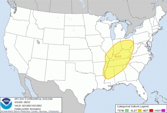
On the February 29th, 2012, the Storm Prediction Center had the entire Tri-State in a slight risk for severe storms and mentioning a threat for tornadoes:

day3

In the early morning hours of March 1, 2012, the Storm Prediction Center upgraded the Tri-State to a moderate risk and mentioned a threat for “long track” and “strong” tornadoes:

day2

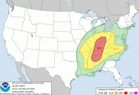
The Ohio Valley remained under a moderate risk until 7:58am eastern time on March 2. At 7:59am, parts of the Ohio Valley were placed in a rare Storm Prediction Center high risk, but the Tri-State was not included yet:

day1-1

I remember setting my alarm for 7:45am on March 2nd just to see if the Storm Prediction Center would put us in a high risk. They didn’t at 7:59am, so I went back to bed for a couple of hours.

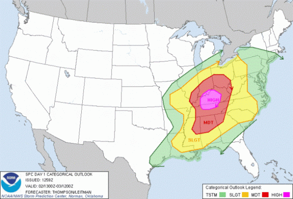
By 10:30am, I was back awake, and watched as the Storm Prediction Center put the Tri-State in a “high risk”, suggesting that long-track and potentially violent tornadoes were imminent:

day1-2

I was into work shortly thereafter. Until about 1:00pm in the afternoon, it was a “waiting game.” No supercells had popped up in our area, but we knew the powerkeg was about to blow. High-resolution models suggested rotating storms and supercells were going to explode in the afternoon, but they disagreed on exactly where. Between and 1 and 2pm, Tim Hedrick and I watched as three different supercells blew up in southwestern Indiana over the span of two counties in less than 15 minutes. When Tim says, “I’ve never seen supercells go up on radar that quick near here. Ever.” you believe him. In 20 minutes, Dubois and Perry County Indiana went from having just cumulus clouds to tornadoes.

A lot of the suspense about what was going to happen and where was resolved by 2:30pm in the afternoon; supercells in southern Indiana were producing damage, and there were numerous indications from spotters that the damage was extensive and the tornadoes were strong or violent. As a meteorologist, I knew there was a chance for this to happen, but until it had been confirmed, the magnitude of this event didn’t really hit me.

Between 2:30 and 3:30pm, we were just waiting for the worst. My tweets from to 2:30pm to 3:45pm became more and more urgent:

twitter3212

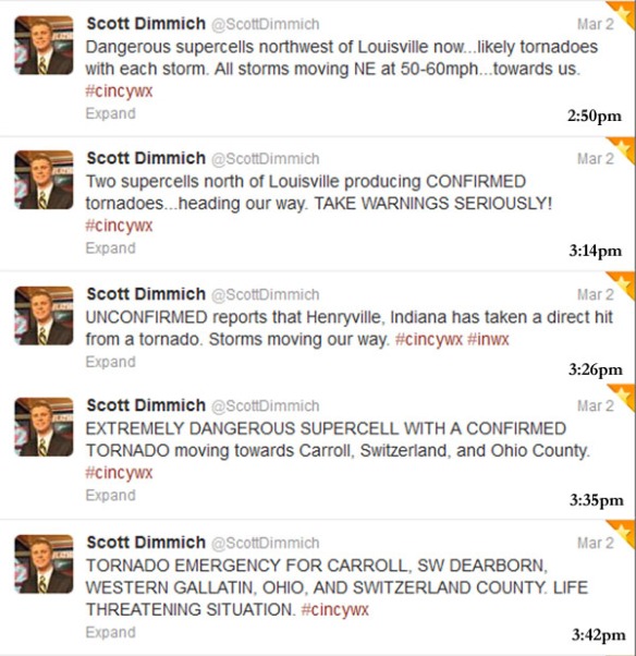
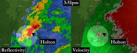
There were reports of tornadoes with the two supercells rolling up I-71, but the focus had to be turned to Ripley County suddenly as a supercell in Jennings County, Indiana pushed east. This cell would produce a EF-3 tornado and kill two in Holton:

TCVGholtonZandV2

Thankfully, the storm that produced a tornado in Ripley County would quickly die, but this event was just beginning for northern Kentucky and southwestern Ohio. While reports of tornadoes and funnel clouds came in from Carroll, Gallatin, and Owen County, the rotation in the northernmost supercell tightened quickly. The first, second, and only Tornado Emergencies ever issued by the National Weather Service in Wilmington were issued for this cell. Looking back at our severe weather coverage, I noticed my hand and the warning printout I was holding were shaking as I announced the first Tornado Emergency on the air. A family friend of mine several weeks later called me out on my hand shaking. She told me that was her first indication from me that this was going to be bad event.

By the time the storm was in southern Boone and Campbell County, damage was already being done; some of the debris from the violent EF-4 tornado in Piner/Crittenden could be seen on the FAA Doppler radar in southern Kenton County just before 4:30pm:

pinertdwrZandV-ZandVshaded

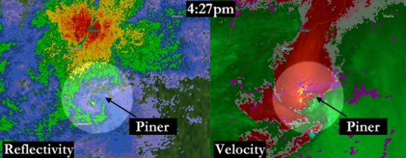
At first, the debris ball (shown at the end of the hook echo in the left side of the above image) wasn’t apparent. Data were only available from the FAA radar every 6 minutes on March 2, 2012, so word of the debris ball first came from the National Weather Service in Wilmington (who could see the radar data every minute). This debris ball on radar was the second sign to me (once storms were in the viewing area) that this would likely be a deadly and historic event. In the over 20 years I’ve lived in Cincinnati, I had never heard of or seen a debris ball on a local radar.

A second debris ball showed up on the FAA Doppler radar in southern Campbell County as the northernmost supercell hit Peach Grove, Kentucky:

peachgrovetcvgZandVwithmoscow

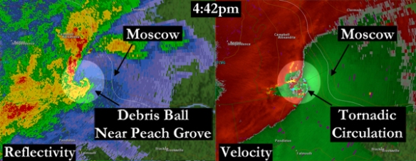
This storm went on to hit Moscow and Hamersville, Ohio, producing EF-3 damage and killing 3. Initially, this report of damage in Moscow was delayed; I remember it was at least 20 minutes between Moscow was hit and when we first heard about the damage.

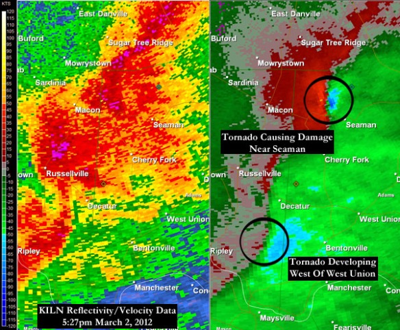
After the tornado had caused damage in Moscow, fatigue began to become a factor. We had been on the air for more than two hours and reports of damage were coming in every couple of minutes. There was no time to be tired, though. 4 more tornadoes would occur after the damage in Moscow, including an EF-1 in Seaman, Ohio and two tornadoes near West Union. The rotation from each supercell in Adams County could easily be seen from NWS Wilmington’s radar just before 5:30pm:

mar1-seamanwestuniontor

By sunset, 9 tornadoes had raked across the Tri-State, and 3 of them were major tornadoes (given a EF-3 or greater rating):

mar1-tortracks

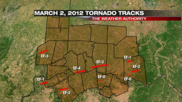
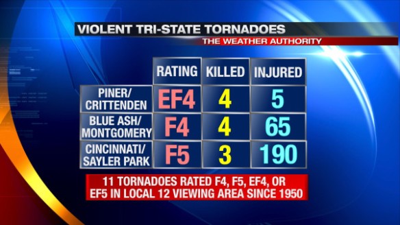
Originally, the Piner/Crittenden tornado was given an EF-3 rating; on the Friday after the outbreak, the National Weather Service upgraded the tornado to an EF-4. The Piner/Crittenden was only the 11th tornado in the Tri-State since 1950 to be classified as a violent tornado:

mar1-violenttors

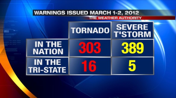
16 Tornado Warnings and 5 Severe Thunderstorm Warnings were issued for the Tri-State on March 2nd, 2012. While this is a large number of warnings in our area on one day, it is a small fraction of the number of Tornado and Severe Thunderstorm Warnings issued in the entire country on March 1-2, 2012:

mar1-mar2warnings

After looking through the data, there are three things that stand out to me about the tornado outbreak of March 2, 2012. For the first time ever, the National Weather Service issued a Tornado Emergency for our area (not once, but twice). A Tornado Emergency is issued when a large, confirmed tornado threatens a highly populated area. Second, three major tornadoes were confirmed in the event. The last time 3 major tornadoes were confirmed in our area on the same day before March 2, 2012 was on April 3, 1974. Lastly, March 2, 2012 now stands as the deadliest severe weather day in the Tri-State since official NWS records began in 1950.

There is no doubt that this was the biggest event of my career so far and likely will be for the rest of my life. I still get emotional thinking about March 2, 2012. As a meteorologist, you do all you can do to get the word out about severe weather in the days and hours leading up to the event; when anyone dies on your watch, you take it personally and you wonder if you could have done more. I hope that something like what happened on March 2, 2012 in this area never happens again; unfortunately, events like these have happened and will happen again in time.