Severe Threat Tonight And Early Wednesday

The Cincinnati area remains under a SLIGHT risk for severe storms late tonight and early Wednesday; the Storm Prediction Center has placed the southwestern Ohio Valley, the southeastern Mississippi Valley, and much of the Mid-South under a MODERATE risk for severe storms tonight and early Wednesday:

jan29-spcoutlook

This morning’s model runs suggests damaging straight-line winds will be the main severe weather threat in the Tri-State early tomorrow. A line of showers and thunderstorms has already formed over the Mississippi Valley and southern Plains; this line will be pushing east through the night and tomorrow. The latest high-resolution WRF model has a squall line along the Wabash and Mississippi River at 1am tonight:

jan29-6zwrfradar

By 7am, the WRF has the squall line (and perhaps a secondary line showers and thunderstorms) moving the Tri-State:

jan29-12zwrfradar

By 1pm Wednesday, the WRF has rain and thunderstorms moving east of Cincinnati and through the Mid-Atlantic/Carolinas:

jan29-18zwrfradar

The WRF has a large swath of 60mph+ winds just above the ground (in orange and bright red) in the western Ohio Valley by midnight ET:

jan29-5zwind

By 4am, that swath of gusty to damaging winds has pushed east into the Tri-State:

jan29-9zwind

Strong winds may proceed storms late tonight.

Even the latest HRRR model has damaging winds (near the arrow and as thunderstorms come through) in southern Illinois, southwestern Indiana, and western Kentucky by midnight:

jan29-hrrr5zwinds

While the best tornado threat will be well southwest of the Tri-State early Wednesday, the tornado threat (while it is small) can’t be ruled out. SPC’s version of the WRF model has the best potential for rotating thunderstorm updrafts along the Mississippi River at 1am tonight:

jan29-udhelicity6z

By 6am, the WRF suggest there may be some rotation in thunderstorms moving through the Tri-State:

jan29-udhelicity11z

Summary

Damaging straight-line wind continues to be the main severe weather threat locally early Wednesday. Tornadoes and large hail will secondary threats, with the greatest threat for each staying southwest of the Tri-State. Showers and thunderstorms will be moving through tomorrow morning between 2 and 11am, with the best threat for rain and storms (including strong and/or severe storms) between 5 and 9am.

Please stay safe and weather aware tonight and early Wednesday. Having a NOAA Weather Radio on and programmed correctly could save your life!

Update On Storm Threat Early Wednesday

The next 24 hours will be fairly quiet in the Ohio Valley, but a threat for storms continues in the Ohio Valley Tuesday night and early Wednesday. Severe weather is not a guarantee, but the threat for severe weather has increased since yesterday.

This morning’s WRF model suggests clusters of thunderstorms will be northwest of the Tri-State for mid-afternoon Tuesday:

jan28-4kmwrf20ztue

Also note the line of showers and thunderstorms organizing in the Mississippi Valley tomorrow afternoon. This morning’s WRF model has that line of showers and thunderstorms (and perhaps some individual cells ahead of the line) moving into the western half of the Tri-State by 4am Wednesday:

jan28-4kmwrf9zwed

The WRF model has this line of showers and thunderstorms moving east of Cincinnati by 10am Wednesday:

jan28-4kmwrf15zwed

As I mentioned in yesterday’s blog post, damaging winds will be the main severe weather threat early Wednesday morning. One indication of this is the strength of the wind 5,000 feet above the ground; this morning’s NAM model shows 60-80 knot (70-95mph) winds 5,000 feet above the Tri-State at 7am Wednesday:

jan28-12znam85012zwed

This morning’s GFS model has winds about as strong at 1am Wednesday in the Ohio Valley:

jan28-12zgfs8506zwed

If these winds can be transferred down to the ground, storms may produce damage.

When it comes to wind shear, the speed shear (the change in wind speeds going away from the ground) is impressive but the directional shear (often needed for tornadoes and defined as the change in the wind direction going away from the ground) is not as impressive. For this reason, the latest SREF model from the Storm Prediction Center has the best tornado support along the Mississippi River at 1am Wednesday (Cincinnati is the blue dot):

jan28-spctor6zwed

Summary

Damaging straight-line winds will be the main concern with any strong storms in the area early Wednesday morning. Storms will likely arrive in the Tri-State in a weakening mode, but storms may still be strong or even severe. Large hail and heavy rain are secondary threats with the strongest storms, and the tornado threat is the lowest threat. Be prepared for heavy rain and gusty winds during Wednesday morning’s commute.

A Closer Look At A Strong Storm Threat Early Wednesday

Last last week, there were indications from computer forecast models that there would be some instability available for thunderstorms  in the Ohio Valley Tuesday night and Wednesday. Based on upper-level support alone, the support for heavy rain Tuesday night and Wednesday has been in the forecast since last Friday. The thunderstorm threat will need to be monitored closely nearing mid-week.

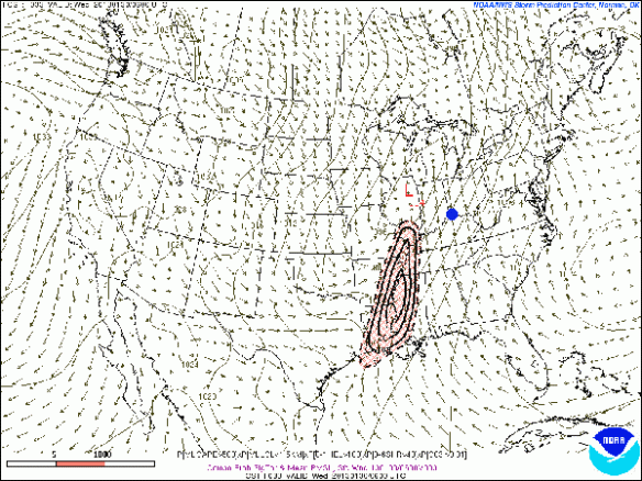
For now, the severe weather threat in the Tri-State is not a major concern, but strong or severe storms can’t be ruled out. The main reason why severe weather will be favored outside of the Tri-State will be the time of day. The latest round of model data suggests the cold front – the surface feature supporting the chance for thunderstorms early Wednesday in the heart of the Ohio Valley – will be moving through during the early morning commute Wednesday, as NOAA’s Hydrometeorological Prediction Center shows in their latest forecast surface analysis:

jan27-hpcday3

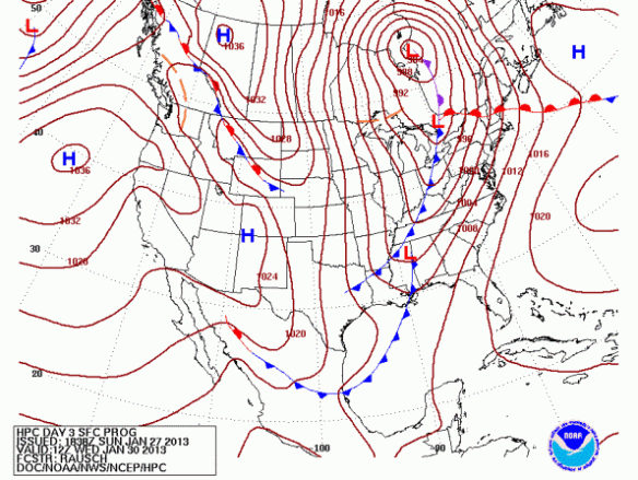
If this cold front was moving through during the afternoon (when instability and the temperature would be higher), the risk for severe weather would be noticeably higher. Since the cold front (and it’s associated thunderstorms) will be moving through late at night, instability will be lower, which tends to support a lower severe weather threat.

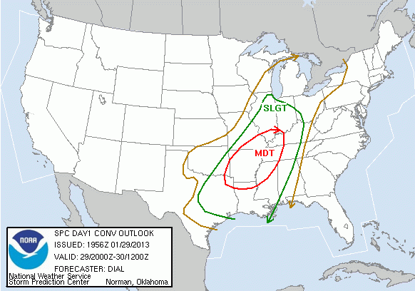
This morning, the Storm Prediction Center felt the best severe weather threat Tuesday morning through Wednesday morning was west of the Tri-State, where greater instability and low-level moisture would be focused:

jan27-spcday3

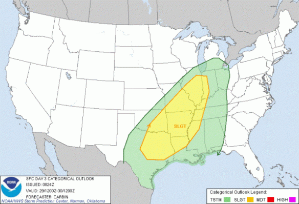
This is a rather large “slight risk” area from the Storm Prediction Center. While not likely, they may be looking to issue a moderate risk in the Ark-La-Tex, where shear and dewpoints will be elevated and the tornado/large hail threat will be higher. The Storm Prediction Center, though, is likely going to wait until more model runs complete before making adjustments and/or issuing a moderate risk. SPC has placed much of the Mid-Atlantic and Carolinas under an enhanced risk for severe storms Wednesday morning and afternoon (highlighted in red):

jan27-spcday4

The Tri-State has not been placed the Tri-State under a slight or enhanced risk for severe weather yet, but that may change.

One thing I’ll be watching as new models come in is the strength of winds aloft, especially 5,000 feet or so above the ground. Without going into great detail, strong winds 5,000 feet or so above the ground often serves as a signal that damaging straight-line winds are possible in an otherwise favorable thunderstorm environment. In other words, these strong winds aloft don’t always mean an area will see damaging winds, but it is a concern when thunderstorms are forecast.

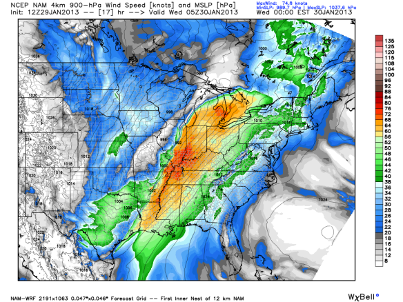
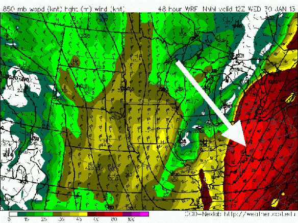
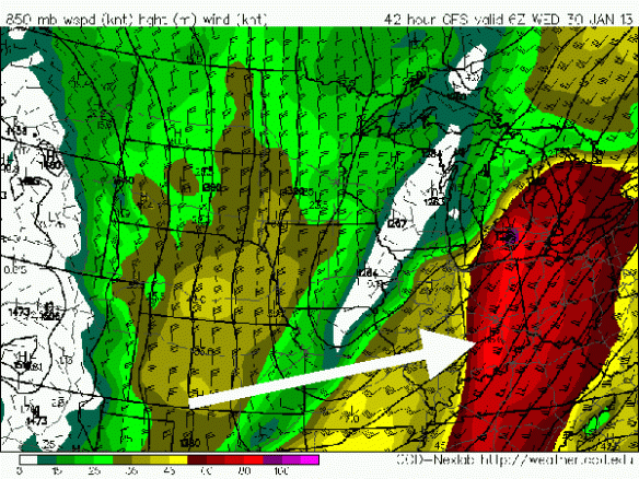
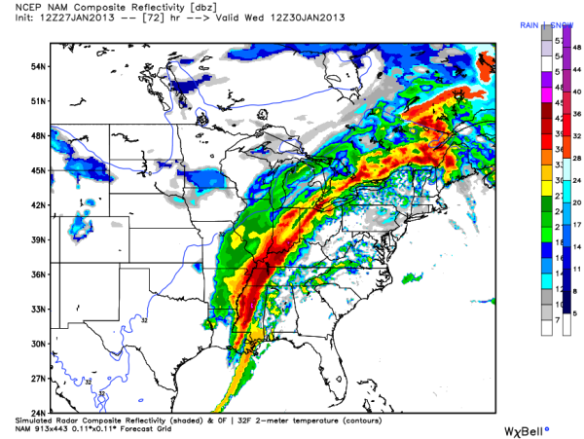
So what do the winds look like 5,000 above the ground Tuesday night and Wednesday? This morning’s NAM forecast model suggest winds will be roughly 50-60 knots (60-70mph) overhead at 7am Wednesday morning (Indiana, Ohio, and Kentucky are on the right half of the screen):

jan27-850wind12zwednam

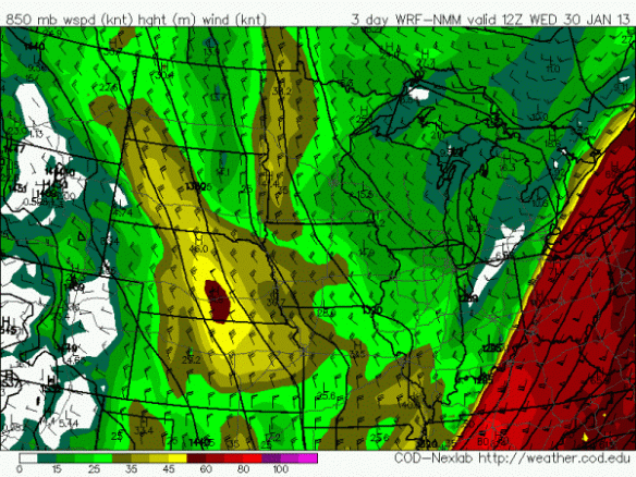
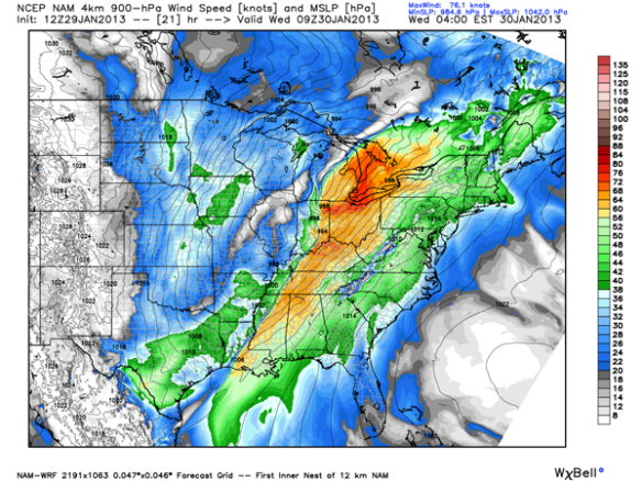
These are fast winds! This morning’s GFS model also suggests winds will be 50-60 knots (60-70mph) 5,000 above the ground at 7am Wednesday morning:

jan27-850wind12zwedgfs

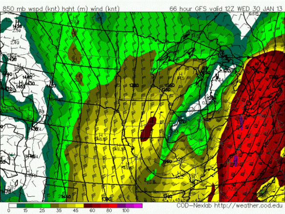
In heavy rain, most – if not all – of these winds tend to be mixed down to the ground, and we can get blasted with strong or severe winds. In this particular setup, this is not a guarantee, but it is something to watch. 

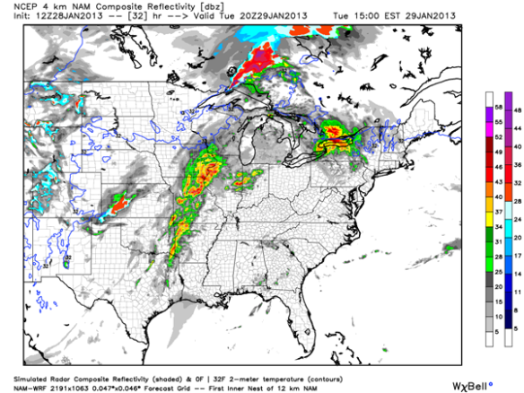
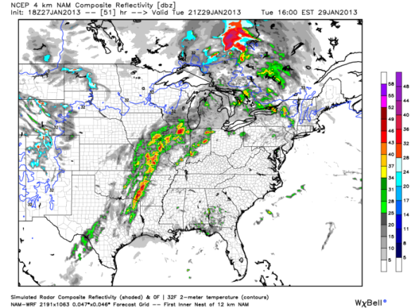
With storms gradually weakening to our west late Tuesday as instability drops, our severe weather threat is conditional. This morning’s high-resolution WRF model has numerous showers and thunderstorms to our west by 4pm Tuesday:

jan27-simrefl21ztues

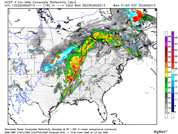
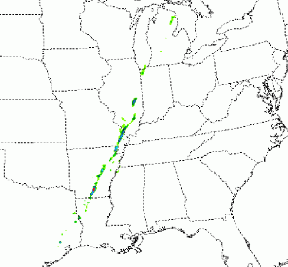
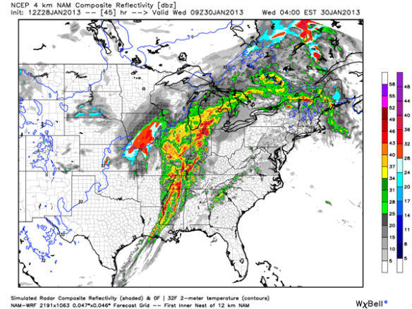
The latest high-resolution WRF model has showers and thunderstorms congealing into a line by 1am Wednesday:

jan27-simrefl6zwed

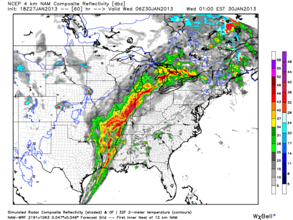
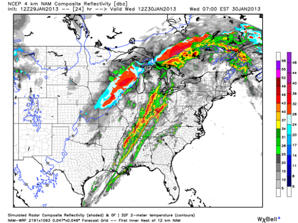
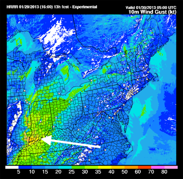
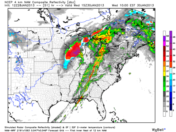
While the high-resolution WRF model doesn’t go out through the morning commute Wednesday, a slightly lower resolution WRF model does…and here’s what it thinks the radar will look like by 7am Wednesday:

jan27-simrefl12wed12km

With this “future radar” product painting yellow and red colors in our area, heavy rain is a concern, but this also highlights the potential for a solid line of strong or severe thunderstorms to sweep through the Tri-State.

Summary

There is still uncertainty about the strength and timing thunderstorms Tuesday night and early Wednesday. The time of day tends to favor weaker storms, but strong winds above the ground suggest gusty or damaging winds are possible with any strong storm that is able to form.

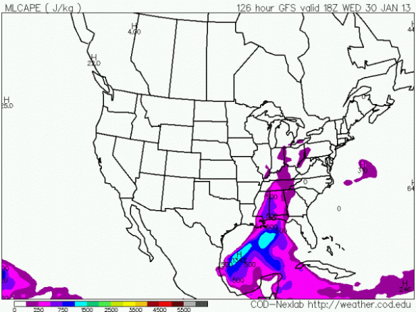
Models suggest better support for severe storms (higher dewpoints, great shear, better instability, and stronger lift) will be closer to the Mississippi River. There are also indications from the newest computer model runs that we will get “cut off” from Gulf moisture that will fuel thunderstorms.

Storms will likely be in a weakening mode as they arrive in the Tri-State late Tuesday night and Wednesday. At this time, isolated strong storms appear more likely than a widespread severe weather event.

Stay tuned for updates! I hope to have a new blog entry up tomorrow…

Weekend Starts Quiet, Ends With A Mix Of Precipitation

The area of low pressure that gave the Tri-State a quick shot of snow is heading east in a hurry; high pressure over the Mississippi Valley is already moving in from the west. The clearing line along the Indiana/Illinois border now will be moving into the Tri-State early this evening. By late evening, the sky overhead will be clear to partly cloudy. Tonight’s hour-by-hour forecast shows temperatures falling into the upper teens late:

jan25-tonighthbh

High pressure will settle into the Ohio Valley Saturday. With high pressure nearby, ample sunshine is forecast tomorrow morning, and a partly cloudy sky is forecast Saturday afternoon:

jan25-saturdayhbh

High pressure will push east Saturday night and early Sunday, allowing low pressure to move in from the west. Mid- and high-level clouds will increase Saturday night, and only filtered sun is expected Sunday. Sunday’s hour-by-hour forecast shows a mix of freezing rain, sleet, snow, and rain developing in the Tri-State Sunday afternoon:

jan25-sundayhbh

Temperatures will be above freezing most if not all of Sunday night, so the mix of precipitation types will likely transition to all rain by early Monday morning. Only rain is forecast Monday afternoon through Wednesday. While there are large model discrepancies in next week’s forecast, the latest GFS forecast model shows some limited instability (shown in purple) in the Tri-State Wednesday afternoon:

jan25-gfscape18zwed

For this reason, a mention of thunderstorms will be put into the forecast Wednesday.

Cold air is likely to return late next week. Little to no snow accumulation is expected Thursday as a cold front sweeps through the Ohio Valley.

Accumulating Snow Likely Friday

Two different areas of low pressure and a large upper-level disturbance approaching the Ohio and Tennessee Valley tonight will produce snow in the Tri-State tomorrow. This is not going to be a big winter storm, but accumulation will be widespread.

The National Weather Service has posted a Winter Weather Advisory for the Tri-State. This advisory will be in effect from 6am to 5pm Friday:

jan24-wwa

The heaviest snow will likely fall between 9am and 3pm.

This morning’s Microcast model run has a good handle on the timing of snow Friday. At 8am Friday, light snow will be moving in from the west:

jan24-mc8amfri

By noon Friday, Microcast suggests snow will be widespread:

jan24-mc12pmfri

By late Friday afternoon, Microcast shows snow exiting the Tri-State:

jan24-mc6pmfri

By early Friday evening, most in the Tri-State will get 1-2″ of snow accumulation; some will see 2-2.5″ of accumulation. Overall, Microcast has a good handle on amounts, but amounts for specific towns on this map are approximate:

jan24-snowtotals

As new model data comes in, we will adjust totals through the night and early tomorrow. Please be careful traveling tomorrow!

Remembering The Great Blizzard Of 1978

The winters of 1976-1977 and 1977-1978 were among the worst the Tri-State has ever seen. In January 1978, 31.5″ of snow fell in Cincinnati, the most amount of snow in a single month since official records began in November 1870. The second snowiest month on record was January 1977, when 30.3″ of snow fell. With an average temperature of only 11.5°, January 1977 was also the coldest month on record in the Queen City.

Part of January 1978’s large snow total fell between January 25 and January 27 during what many call the “Great Blizzard of 1978″; daily weather records taken at the Cincinnati/Northern Kentucky International Airport show 6.9” of snow fell in those 3 days:

jan24-blizzarddaily

The snow depth of 11″ on January 27, 1978 ranks as the 24th (tie) largest early morning snow depth in Cincinnati on record; the all-time record early morning snow depth in Cincinnati is 15″ set on both January 15 and 16, 2010.

Blizzard is not defined by how much snow falls but instead by the visibility and wind. A blizzard occurs when the follow criteria are met:

– There are sustained, frequent gusts over 35mph
– Blowing or drifting snow causes the visibility to drop below 1/4 of a mile
– Both of the previous two conditions are met for at least 3 hours

While the snow amounts were impressive during the Blizzard of 1978, the wind speeds, temperatures, visibilities, and duration of blowing and drifting snow was a bigger story. Here are some of the weather observations taken at the Cincinnati/Northern Kentucky International Airport on January 26, 1978:

jan24-jan26blizzardobs

The official early morning surface map on January 25, 1978 from the National Weather Service showed two areas of low pressure in the eastern 2/3rds of the nation; the one closest to the Gulf of Mexico would rapidly intensify 24 hours later:

jan251978sfc

On the morning of January 26, 1978, that area of low pressure was centered near Detroit. This low was among the strongest ever recorded in the United States for a non-tropical system:

jan261978sfc

What did the blizzard look like? Here are some snapshots on January 26, 1978 from the WKRC-TV video archive (shot on 3/4″ tape):

blizzard1978-1

blizzard1978-2

In 1998, the National Weather Service forecast office in Wilmington released a statement that gives perspective on the Great Blizzard of 1978 in Cincinnati: http://www.erh.noaa.gov/iln/PSACVG.htm

The National Weather Service also released a statement putting the blizzard in perspective for Dayton and Columbus. The links to each statement are linked here, respectively: http://www.erh.noaa.gov/iln/PSADAY.htm, http://www.erh.noaa.gov/iln/PSACMH.htm.

What were your memories of the Great Blizzard of 1978?

More Snow Coming Soon

The flurries and snow showers passing through the Ohio Valley today will end tonight, and clouds will gradually dissipate this evening and overnight.

With high pressure nearby tomorrow, our attention turns to a late week system that looks to bring us accumulating snow. Temperatures will be around 20° early Friday and around 30° by late Friday afternoon; this is certainly cold enough to support snow and set concerns for freezing rain, sleet, and rain aside…at least for now.

When it comes to forecasting an amount of snow, meteorologists often see what liquid amounts computer models are suggesting and then convert that liquid amount to a snow amount based on temperatures. Here is what the latest forecast models think for liquid amounts Friday morning through Friday night:

jan23-fcastliquid

Notice one model has no precipitation for our area Friday. We are ignoring this model for now. Because temperatures will in the 20s Friday, snow to liquid ratios will be roughly 15:1 to 20:1; in other words, temperatures Friday suggest forecast liquid amounts need to be multiplied by 15 or 20 to get snow amounts. When the calculations are made, here’s approximately how much snow this morning’s models are suggesting for Friday:

jan23-fcastsnow

Remember, these are computer model suggestions, not a forecast. Given the good consensus among models (with the exception of the model that gives us nothing and is being thrown out for now), we are fair game for a couple of inches of snow Friday.

Specifics on snow amounts in the Tri-State will likely have to wait until tomorrow. Stay tuned!

Cool Stuff: Cooling Stack Enhanced Snow In The Tri-State This Morning

Have you ever heard of “cooling stack enhanced snow?” Odds are you probably haven’t, but it was the reason behind light snow bands in the Tri-State this morning.

When “lake effect snow” or “lake enhanced snow” falls in the Ohio Valley, cold air is passing over a relatively warm lake, such as Lake Michigan. In the Tri-State, bodies of water are very small, and lake effect snow bands rarely form downwind of these bodies of water.

While we did not have “lake effect snow” or “lake enhanced snow,” many saw “cooling stack enhanced snow.” Cooling towers at Tri-State power plants often release warm, moisture-laden air into the atmosphere. Because their is a large temperature difference between this air and the air surrounding it, the air from the cooling stack cools and condenses rapidly, forming a cloud. Excess moisture falls from the cloud as light snow.

This process happened early this morning downwind of the Miami Fort Power Station in northern Boone County near the Cincinnati/Northern Kentucky International Airport:

jan22-coolingexplainer

At 8:30 this morning, you could see bands of snow on our live radar over northern Kentucky and downwind of the Miami Fort Station:

jan22-830tdwrwest

You could also see a narrow band of light snow on radar east-southeast of the Zimmer Power Plan in Moscow at 8:30 this morning:

jan22-830amtdwreast

We don’t know how warm the air was coming out of the cooling stack this morning, confidence is high that the temperature difference between this air and the air surrounding it was large. Early morning lows were reached around the time these bands were forming and producing light snow, and it was cold:

jan22-earlyamlows

Temperature And Wind Chill Trends Through Mid-Week

As promised over the last several days, arctic air is on the move. The core of this arctic air will remain over the Great Lakes and southern Canada through mid-week, but it will still be very cold over the Ohio Valley Monday, Tuesday, and Wednesday.

As of 8pm Sunday night, temperatures are mostly in the 20s and 30s:

jan20-8pmtemps

Most locations in the Ohio Valley are 10-25° colder than they were 24 hours ago:

jan20-8pmtempchange

Northwesterly flow has dominated for most of the day in and around Cincinnati, allowing the arctic air centered over southern Canada to be transported into the United States. As of 8pm Sunday night, most major cities in Canada are below zero:

jan20-8pmcanadatemps

It will be very cold Monday, and it will also be quite windy (especially during the afternoon); winds will likely be out of the west between 5 and 15mph Monday morning and between 15 and 25mph Monday afternoon. As a result, wind chills will be in the teens and single digits even though temperatures will be in the low to mid 20s all day:

jan20-mondayhbhmg

The core of arctic air will dive farther south Monday night and Tuesday. Winds will be slightly weaker compared to Monday afternoon, but wind chills will still be between -10° and 10° from 7am to 7pm Tuesday:

jan20-tuesdayhbhmg

Thanks to flow out of the east and southeast (instead of the northwest) and arctic air lifting north, Wednesday won’t be as cold. Winds will also relax some Wednesday thanks to high pressure moving in from the west. Temperatures are forecast to be in the teens and 20s Wednesday, and wind chills will be in the single digits and teens:

jan20-wedhbhmg

The National Weather Service Forecast Office in Wilmington may issue a Wind Chill Advisory for parts of the Tri-State Tuesday morning. A Wind Chill Advisory is issued when winds are expected to be at least 10mph and the wind chill is forecast to drop between -10° and -24°. The minimum wind chill Monday night or Tuesday morning should be around -10° in Cincinnati; -10° to -15° wind chills are possible north of Cincinnati.

Need to get prepared for the cold? Here are some cold safety tips from the Centers for Disease Control: http://www.bt.cdc.gov/disasters/winter/guide.asp

36 Years Ago Today: The Coldest Morning In Recorded Cincinnati History

Today marks the 36th anniversary of the coldest low temperature on record in Cincinnati. The Cincinnati/Northern Kentucky International Airport dropped to -25° on January 18, 1977; the high temperature that afternoon was only 0°.

It was brutally cold in the Tri-State that morning, but a map of early morning lows for January 18, 1977 reveals that some spots got colder than others:

jan18-jan181997lows

Data from NOAA’s Earth Systems Research Laboratory shows arctic air (in purple) surging not just into the Ohio Valley that day, but all the way down to Florida and the Gulf of Mexico:

jan18-850anom181977

While you may not remember the date, you may remember the Ohio River being frozen. Video from the WKRC-TV archives shows many walking across the Ohio River that day:

frozenriver

Many unsuccessfully tried to drive their cars across the river while the river was frozen. You may also remember seeing the Cincinnati buildings perspiring in the arctic air:

coldcity

Cincinnati has only dropped under -20° four times since the coldest day on record…once each in January 1984 and 1985 and twice in January 1994. This anniversary is a reminder that arctic air can – and often does – push south this time of the year. While it won’t be as cold as January 18, 1977, next week looks to be the coldest stretch so far this season.