March Marks The Start Of The Tri-State’s Peak Severe Weather Season

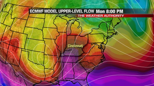
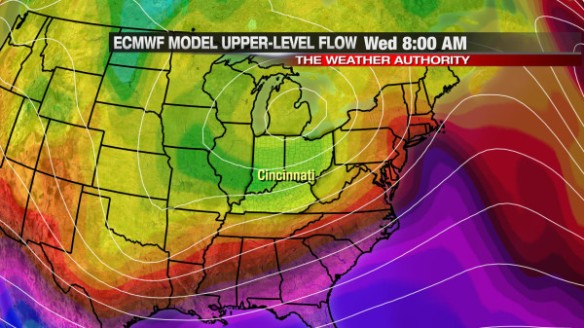
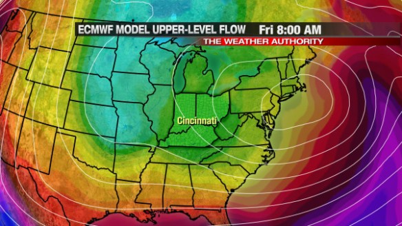
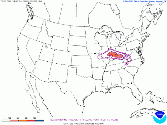
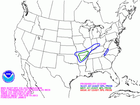
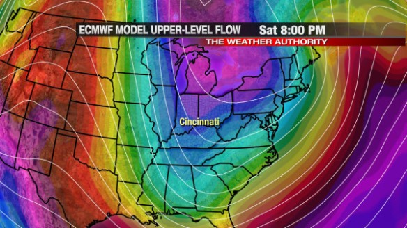
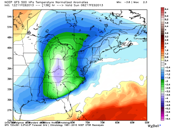
Don’t let the snow, snow grains, thick clouds, and cold fool you; March is the start of our peak severe weather season in the Tri-State. In 2012, severe weather had a early, deadly start with a tornado outbreak on March 2nd. This event was unusually early in meteorological spring, but it is a reminder that severe weather can happen any time of the year and often happens outside of our main severe weather season.

Long-term trends suggests the potential for severe weather really ramps up in March, but most tornadoes and severe storms affect the Tri-State in the late spring and summer. Since 1950, the most active month for tornadoes in the Tri-State is April; it’s a close race for second place between May and June, and July is firmly in 4th place:

feb28-blog-torbymonth

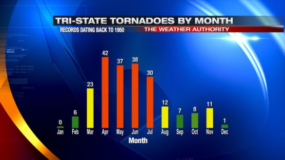
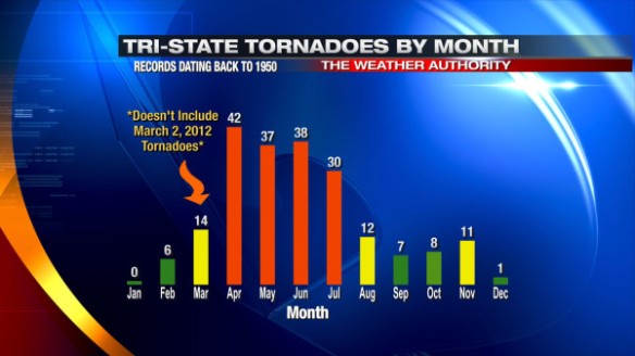
23 tornadoes have been confirmed in the Tri-State during the month of March. 9 of these tornadoes occurred on March 2, 2012. If the March 2, 2012 tornado outbreak had never happened, March would have similar tornado count to August and November:

feb28-blog-torbymonthno322012

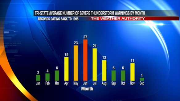
March is also not the most likely month to see Severe Thunderstorm Warnings issued, but the average number of Severe Thunderstorm Warnings issued in the Tri-State goes up each month from January through June:

feb28-blog-svrbymonth

On average, only two Flash Flood Warnings are issued in March in the Tri-State:

feb28-blog-ffwbymonth

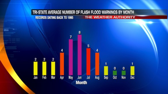
May and June are the busiest months for flash flooding in the Tri-State, but flash flooding can still occur in the summer and early spring in long-duration heavy rain events or with slow-moving thunderstorms in the area.

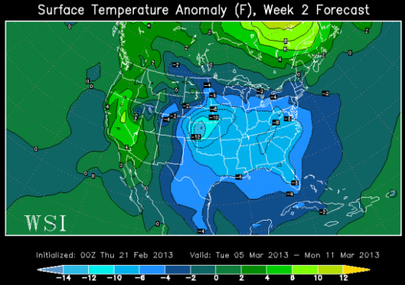
While the week ahead looks rather cloudy and cold, our peak severe weather season is coming. These cloudy, cold days are the perfect time to prepare for severe storms. Make sure you have a severe weather safety kit with water, shoes, medicine, flashlights, and batteries.

Where The Upper-Level Low Goes Later This Week

There is no doubt that a cold front will sweep through the Tri-State late Monday night and early Tuesday. This front will bring rain, and it will – eventually – help to bring cold air from Canada into the Ohio Valley. In the wake of this cold front, an upper-level area of low pressure will get cut-off from the upper-level flow; in turn, this upper-level low will sit and spin over us until the jet stream can dislodge it to our northeast. While there is high confidence this upper-level low will stick around into the second half of the work week, there is great uncertainty about when it will leave.

Both this morning’s GFS and ECMWF agree on a subtle warm-up from Sunday into Monday. I’m forecasting a high temperature of 48° Monday afternoon and a low temperature of 36° Monday night. The latest model data suggests the temperature may rise late Monday night as low-level moisture gets pulled into the region on a strengthening east-southeasterly wind.

The GFS model has a surge in warmth midnight Tuesday in the Tri-State ahead of the cold front:

feb24-gfs12amtues

This morning’s ECMWF model is nearly identical to the ECMWF at midnight Tuesday; it has a surge in warmth ahead of the front and the upper-level low centered over the Mid-South:

feb24-ec12amtues

The forecast gets a bit messier nearing mid-week. This morning’s GFS model has the ill-defined upper-level low in the Ohio Valley by 8am Wednesday morning:

feb24-gfs8amwed

The latest ECMWF model run has the upper-level area of low pressure over Cleveland by 8am Wednesday…and brings slightly colder air to Cincinnati by then compared to the GFS model:

feb24-ec8amwed

The GFS and ECMWF aren’t really that different by mid-week, but the differences between the GFS and ECMWF become greater nearing next weekend. The GFS has the main upper-level low over New England and a secondary low trying to form over the interior Midwest:

feb24-gfs8pmthur

Also, notice the colder air (shades of blue) extending out of southern Canada. If you assume the GFS model verifies, this re-enforcing shot of cold air will mean clouds, flurries, and snow showers will stick around through next Saturday night and Sunday. This morning’s ECMWF model has a different solution; it says the main upper-level low is over Boston, has no secondary low forming west of the Great Lakes, and has no big surge of arctic cold air diving south out of Canada:

feb24-ec8pmthur

If you believe the ECMWF model, snow showers and flurries will stick around through Friday but will be gone by Saturday and Sunday.

Which model do I believe? I’m leaning towards the GFS for now, but I still give a nod to the ECMWF; I have flurries and snow showers in the Tri-State Thursday, Friday, and Saturday and only flurries early Sunday.

This forecast will likely need to be revised as next weekend nears. Regardless of which model you believe, winter is coming back later this week!

Winter Is Not Over: Long Range Forecast Looks Cold And Snowy

After a night and early morning with ice, low pressure is moving east, and high pressure is moving in from the west. This weekend will be reasonably warm and quiet, but cold air will pour in from Canada by the middle part of next week.

There are some differences among the newest model data on how cold we will get next week. This morning’s GFS model suggests temperatures will be 5-15° below average Wednesday afternoon (shades of blue and green):

feb22-gfs2manom18zwed

I agree with this model forecast. We’ll likely have high temperatures in the mid 30s Wednesday. When you look about 5,000 feet above the ground next Saturday morning, you’ll find temperatures well below average in the Ohio, Mississippi, and Tennessee Valley:

feb22-gfs850anom12zsat

If this model forecast verifies, temperatures may reach into the low to mid 30s in northern Florida early next weekend. This is a longer range forecast (with plenty of room for uncertainty), but it bears watching. Watch out, citrus crops!

This morning’s ECMWF model is also aggressive with a plunge of arctic air sweeping in behind Tuesday morning’s cold front. Notice the surge in warmth 5,000 above the ground Monday morning per the latest ECMWF model run (red and purple colors):

feb22-eculf8ammonday

I expect temperatures to reach to near 50° Monday afternoon before rain moves in from the west. We’ll drop into the 30s Tuesday morning and stay in the 30s Tuesday afternoon. The ECMWF model has plenty of cold air aloft at 8am Wednesday morning (yellow and green colors):

feb22-eculf8amwednes

We’ll be in the 30s all day Wednesday, and the 20s and 30s all day Thursday. Like the GFS, this morning’s ECMWF model suggests even colder air may drop into the Great Lakes and Ohio Valley by next Friday (green and aqua colors):

feb22-eculf8amfriday

If this model forecast verifies, we’ll start next Friday in the mid 20s and finish Friday near freezing.

Next week may be the start of a prolonged colder than average period. The latest ECMWF Weekly model released yesterday suggests the first full week of March will be colder than average in the Ohio Valley:

feb22-ecmwfweekly2

The ECMWF weekly also suggests that temperatures will be closer to average in the following week:

feb22-ecmwfweekly3

Of course, this is just one long range model and is not guaranteed to happen. While the latest ECMWF Weekly suggests much of March will be colder than average, I expect a wide range in high and low temperatures averaging out below average.

Enjoy a quiet, brighter weekend!

Everything You Need To Know About Tonight’s Ice Threat

Tonight is the night; love it or hate it, freezing rain is likely from mid-evening through early Friday morning. This has been a well-advertised event, but there are still some uncertainties regarding the amount of ice any given Tri-State community will get tonight and early Friday.

It is worth nothing that a lot of the ice that accumulates will melt as air and surface temperatures go above freezing tomorrow morning. Roads have been treated fairly well in and around Cincinnati; I am cautiously optimistic there will be few problems in the morning on roads. Sidewalks and cold, elevated surfaces will be favored to get ice accumulations over roads (especially the treated ones).

The National Weather Service in Wilmington has posted a Winter Weather Advisory for the entire Tri-State. It will go into effect at 8pm tonight for everyone and remain in effect for most in the Tri-State through 10am Friday; the advisory will remain in effect Fayette, Union, Franklin, Butler, Warren, and Clinton County through noon:

feb21-wwa

The main window for ice accumulation will be from 10pm tonight through 4am Friday morning, although freezing drizzle and very light freezing rain will be possible in the Tri-State as early as 7 or 8pm. Here’s my latest thinking on this event:

feb21-impacts

How much ice are we going to see? For the entire event, nearly all in southwestern Ohio, northern Kentucky, and southeastern Indiana will see between 1/10″ and 2/10″ of ice accumulation. This morning’s Microcast model run matches my thinking ice amounts:

feb21-iceaccum

There may be some isolated higher amounts in or just outside of the Tri-State, but this will be an exception more than a rule.

What will happen when less than 1/4″ of ice accumulates? You may see one or more of the following overnight and/or early tomorrow morning:

– Icy sidewalks
– Icy windshields
– Ice coated cold, elevated, outdoor surfaces
– Slick roads that are not treated

The following are unlikely this event:

– Power outages
– Widespread icy roads
– Widespread school delays

If you have an ice measurement, please report it! You can find me here:

– Twitter: http://twitter.com/scottdimmich
– Facebook: http://www.facebook.com/pages/Meteorologist-Scott-Dimmich/111711042247661
– Google Plus: http://plus.google.com/u/0/102616416490258159029/posts

Update On Thursday Night Ice Threat

The threat for freezing rain, rain, snow, and freezing rain is still forecast Thursday night. Here in the Tri-State our main focus will be for freezing rain and rain. We don’t always see ice in the winter; this may be our best chance to see ice this season.

There is still uncertainty in the timing, positioning, and strength of this system. A 2° difference in temperature near or above the ground will make a big difference for what type of precipitation you’ll see and when.

For now, it appears our main threat for freezing rain will be between 10pm Thursday and 5am Friday morning. There will be a lot of lift in the atmosphere as this system pushes through the Ohio Valley; there may be some localized pockets of heavier freezing rain and rain Thursday night and early Friday.

Around 11pm tomorrow night, freezing rain will develop in and around the Tri-State, while rain will be favored to our south and snow and sleet will be favored to our northwest:

feb20-ice11pmthur

By 2am, the threat for freezing rain ramps up in and around Cincinnati:

feb20-ice2amfri

By 7am Friday, the odds of rain will be going up as the threat for freezing lifts into northern and central Ohio:

feb20-ice7amfri

While it may be precipitating heavy at times Thursday night and early Friday, air, pavement, and ground temperatures will be hovering around 32°. This limits the potential for ice accumulation tomorrow night some.

How much ice are we getting? It depends on where you live and which model you believe.

This morning’s NAM model keeps the best threat for ice accumulation northwest of Cincinnati and back into the Mississippi Valley:

feb20-namice

This morning’s GFS model is more aggressive with ice accumulation in our area, giving most at least a light glaze:

feb20-gfsice

This morning’s Microcast run is the most aggressive with ice accumulation Thursday night and early Friday. It is highly likely that these amounts are overdone; if this verified, this would be a crippling ice storm, and we are NOT expecting this:

feb20-microcastice

Precisioncast is more realistic with ice amounts, but still may be too aggressive:

feb20-adonisice

Forecast

I still think it is too early to make a specific, county-by-county ice accumulation forecast, but the threat for a widespread, light glaze Thursday night and early Friday is rising. A 1/4″ of ice usually causes power lines to sag or fall completely to the ground; I’m not ready to commit to the possibility of this happening anywhere in the Tri-State yet. Given the lack of consensus in model data, I will not release a specific ice accumulation forecast. Regardless of how much ice falls, it is important to know that roads may be slick and that elevated, cold, outdoor surface may have a coating of ice by late Thursday night.

I may do a video update late tonight, depending on how much time I can find tonight. I will update this blog tomorrow.

Investigating The Possibility Of Ice Thursday Night

With flurries and clouds moving out into early evening and high pressure nearby tomorrow, our main forecast concern in the week ahead is with a late week system. A potpourri of precipitation types (snow, rain, sleet, and freezing rain) are forecast in the Ohio Valley Thursday night.

This will be a tricky forecast, especially with a lack of consensus among models. With a lack of consensus, it is not worthwhile to make a specific county-by-county ice accumulation forecast. We are also more than 48 hours out on this event, supporting the idea that now is not the time to go into specifics.

My focus for this blog post will be on output from the SPC Short Range Ensemble Forecast (SREF) model. The word “ensemble” in meteorology refers to a series of models that are run with different initial conditions; if models with different initial conditions are in good consensus on a particular forecast, confidence is higher than average that particular forecast will verify. Looking at the mean of the SREF models helps to weed out extreme model forecasts.

This morning’s SPC SREF run gives the Tri-State between a 30% and 90% chance (depending on where you live) of measurable ice accumulation between 10pm Thursday and 1am Friday:

feb19-spcsref10pm1amfriiceprob

This morning’s SPC SREF gives the Tri-State a roughly 40% chance that we get at least 0.05″ of freezing rain accumulation (at least a light glaze) between 10pm Thursday and 1am Friday:

feb19-spcsref10pm1amfriice

NOAA’s Hydrometeorological Prediction Center gives most of the Tri-State a 10% chance of 1/4″ of ice accumulation or more Thursday night and early Friday:

feb19-hpcice

1/4″ of ice accumulation serves as a rough milestone for where power lines start to sag or may fall completely to the ground. 1/8″ of ice will lead to some slick roads and sidewalks

This morning’s GFS model gives Cincinnati about 0.2″ and Wilmington about 0.15″ of ice accumulation Thursday night; likewise, this morning’s NAM model gives Cincinnati about 0.15″ and Wilmington about 0.1″ of ice accumulation Thursday night. Again, these are what two models are projecting and is NOT a forecast. I share these totals with you to show that this is not going to be a major ice event but may be more than a nuisance.

What To Expect Thursday Night

Confidence is high that sleet, rain, snow, and freezing rain will overspread the Ohio Valley Thursday evening. Precipitation will likely start as a mix of rain, snow, and freezing rain in Cincinnati with temperatures around freezing. Nearing 12am Friday, the mix of snow, rain, and freezing rain will transition to a rain and freezing rain mix…with a small chance for sleet also. By sunrise on Friday, most – if not all – of the Tri-State will see rain with some freezing rain and sleet mixing in north of Cincinnati.

Right now, I’m thinking some in the Tri-State see a light glaze of ice, especially north of the Ohio River. Temperatures will be in the lower 30s nearing all of Thursday evening; the temperature is forecast rise 1-3° between 10pm Thursday and 7am Friday, which works against the idea of ice accumulation.

A 1-2° change in temperatures Thursday night may have a significant impact on what type of precipitation you see and how much ice you see. It is better to start conservative on an ice forecast and ramp up if needed than to go the other way.

Stay tuned for an update tomorrow!

Rain Tonight, Active And Colder Pattern Ahead

A strong cold front will sweep through the Tri-State early tomorrow morning, bringing rain this evening, a rain/snow mix overnight, and flurries tomorrow afternoon. Mid-week will be quiet, but another system coming later this week looks to bring the Ohio Valley a mess of rain, snow, sleet, and freezing rain.

Everyone will see light rain tonight; some may see brief moderate to heavy rain. By the time this system pushes east tomorrow night, Precisioncast gives us roughly 1/2″ of precipitation (nearly all of this will be rain):

feb17-adonisrain

The higher-resolution Microcast run from this morning gives us about a 1/2″ of precipitation through tomorrow night as well:

feb17-mcrain

Besides Microcast and Precisioncast, the three major forecast models we use in the weather center give us anywhere between 0.19″ and almost 0.6″ of precipitation (mostly rain) through tomorrow night:

feb17-modelsrain

By tomorrow afternoon, we should only have flurries in the area with temperatures nearly steady in the low to mid 30s.

The weather system that is coming later this week looks more interesting and has my attention. A mix of rain, snow, sleet, and freezing rain is likely coming late Thursday and early Friday. The NAM model’s simulated radar product from this morning suggests we’ll see rain over ice by 7pm Thursday night, but I’m skeptical:

feb18-namradar00zfri

The latest run of the GFS model gives Cincinnati about 0.2″ of ice Thursday night and early Friday. Here’s a map of forecast ice accumulation this morning’s GFS model (through 7pm Friday):

feb18-gfsice00zsat

Recent runs of the GFS model have given Cincinnati about 0.1 to 0.2″ of ice accumulation. This is not enough ice to bring down power lines, but it’s enough to make the roads slick. A difference of 2° in the temperature near or above the ground will make a big difference on how much rain, snow, ice, or sleet we get.

Cold And Snow Coming For Late Week

Confidence is high that much colder air is coming for Friday, Saturday, and Sunday. There is, however, some uncertainty on how much moisture will be embedded in this cold air nearing the weekend. The upper-level and surface support for flurries and snow showers is there, but how much upper-level and surface support we get remains in question.

The latest run of Microcast has snow showers and flurries in the area tomorrow, as do most forecast models. Microcast suggests we will see little to no snow accumulation from tomorrow morning through Friday night:

feb14-mcsnow

Nearly all models struggle with finer details, including specific snow amounts. I suspect there will be some instability in the area tomorrow, so quick bursts of snow are more likely than a large swath of snow in any given part of the Tri-State. You can see hints of these isolated pockets of heavier snow around Cincinnati in this afternoon’s NAM model snow output (through 7am Saturday):

feb14-nam18zsnow12zsat

You can also see the isolated, heavier bursts of snow in this morning’s higher-resolution NAM model snow output (through 7am Saturday):

feb14-4kmnamsnow12zsat

For now, Friday’s forecast calls for little to no accumulation for most, but there will be some localized bursts or bands of heavier snow. These small pockets of heavier snow may produce up to 1″ of accumulation. Of course, it is hard to predict where these small-scale features will set up, especially more than 12 hours out.

In addition to snow, we are also tracking the return of cold air for Friday, Saturday, and Sunday. This morning’s ECMWF model shows cold air (in blue and purple) diving south into the Great Lakes and Ohio Valley by 8am Saturday:

feb14-eculf8amsat

While it will be cold this weekend, the latest ECMWF model suggests the jet stream will push back to the north, and warmer air (in orange and red colors) will push back into the Tri-State by 8am Monday morning:

feb14-eculf8ammon

This warm-up will be temporary. A cold front will likely sweep through early Tuesday, bringing the return of cold air and snow by Tuesday afternoon.

We love to hate snow in Cincinnati. Through this date last year, only 3.6″ of snow had fallen in Cincinnati. Since September, over 15″ of snow has fallen in the Queen City. Despite this being a warmer than average winter (so far), we will likely see a near average amount of snow for fall, winter, and spring as a whole:

feb14-snowperspective

Rain And Snow Coming Wednesday…So How Much Snow?

Ever since late last week, we have been discussing the possibility of a rain/snow mix for Wednesday. Some models suggest precipitation tomorrow will be all snow, others suggest it will be a rain/snow mix, and a few say most if not all of the precipitation we get tomorrow will fall as rain.

This will be a tricky forecast because temperatures will likely be near or just above freezing most of tomorrow morning and into parts of Wednesday afternoon. Powdery snow is unlikely Wednesday; in the areas that get snow, it will be very wet and slushy.

Model guidance continues to have the best chance for precipitation south and east of Cincinnati tomorrow morning and afternoon. By late tomorrow afternoon, this slug of moisture will be pushing east in a hurry.

So how much snow are we going to get? The latest run of Precisioncast gives parts of Ohio and Kentucky up to 3/4″ of snow through tomorrow evening:

feb12-adonissnow

This morning’s Microcast run is slightly more aggressive with snow amounts south and southeast of Cincinnati:

feb12-mcsnow

If you believe this morning’s ECMWF model, most are getting snow tomorrow in southwest Ohio and northern Kentucky:

feb12-ecmwfsnow

NAM and GFS runs from this morning give areas south and east of Cincinnati snow, and little to no accumulation elsewhere. This morning’s NAM run gives the far southeastern corner of the Tri-State 1-2″ of snow through Wednesday evening and little to no snow in downtown Cincinnati. This morning’s GFS gives the Tri-State little to no snow tomorrow.

Forecast

I think areas south and southeast east of Cincinnati get up to 0.5″ of wet, slushy snow Wednesday morning and afternoon. A lot of this snow will melt on contact, especially on the roads. Surface pavement temperatures in Kentucky and southwestern Ohio are in the 40s and 50s now; while these temperatures will likely drop some overnight, it will likely be too warm for snow to stick on the roads in most places- especially treated roads – tomorrow morning and afternoon. Air temperatures will also be above freezing most of tomorrow morning and afternoon, working against the possibility for accumulation.

I’ll look over evening model data and update the forecast as needed!

Jet Stream Changes Mean Temperature Changes In The Week Ahead

The temperature has been nearly steady all morning and afternoon in Cincinnati, but the temperature will be fluctuating quite a bit in the next 10 days as the jet stream moves south and retreats back to the north.

For now, the jet stream is to our north; it will likely stay to our north through tomorrow. The latest GFS model has abnormally warm temperatures (in the orange and red colors) in the Ohio Valley at 1pm tomorrow afternoon:

feb11-gfsanom18ztue

On Wednesday, however, the latest ECMWF model suggests the jet stream will dip to the south, bringing slightly cooler air to the region:

feb11-eculf12zwed

This dip in the jet stream will temporary; the jet stream will push back to the north by Thursday. The latest GFS model shows above average temperatures (in orange and red) surging north into the Tri-State with the jet stream retreating back into southern Canada:

feb11-gfsanom18zthur

This change in the jet stream, too, will be temporary; the jet stream will once again push south this weekend, as the latest ECMWF model shows by Saturday night:

feb11-eculf00zsun

This morning’s GFS model shows abnormally cold air (shown in blue, green, white, and purple) aloft by 7pm Saturday night:

feb11-gfstamon00zsun

This cold air aloft will likely support a chance for flurries Saturday, Saturday night, and early Sunday.

While the weekend will be chilly, near or above average high temperatures will likely return by Tuesday. The latest GFS model has above average warmth in the Tri-State  early Tuesday morning:

feb11-gfsanom12ztue

Winter is not over! This up-and-down pattern will likely continue for the rest of February and into early March…