Low and high temperatures have been above average the last few days in the Queen City, but the latest computer guidance suggests cool, Canadian air will arrive by next weekend. While there is no imminent threat for frost with this next shipment of cool air, the likelihood of frost will rapidly increase over the next month.
When forecasting frost, a meteorologist often looks for a very light or calm wind, a mostly clear to clear sky, and temperatures dropping into into or below the upper 30s early in the morning. Frost can form with air temperatures dropping into the mid and upper 30s; temperatures to or below 32° are not needed for frost. Why? The answer to this has to do with how temperatures are measured.
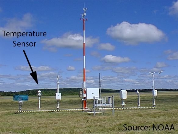
The piece of equipment used to measure weather conditions at most airports in this country – called an Automated Surface Observing System or ASOS – measures the temperature 2 meters above the ground.Here is a picture of an ASOS and where the temperature sensor is located:
Because relatively cold air sinks and warm air rises, temperatures below this sensor are always colder than temperatures at the sensor. For example, the sensor may measure at air temperature of 36°, but the temperature at the ground may be 32° or lower. Patchy frost can form at the ground when the temperature at the sensor drops to 38°.
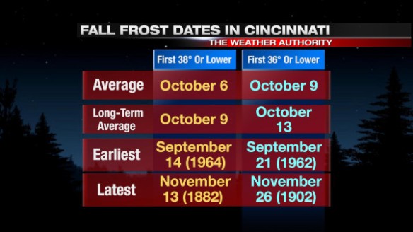
The first frost of the fall in Cincinnati almost always occurs in October; while the exact temperature where frost occurs can vary, using a temperature of 36° or 38° yields roughly the same dates on average:
The first frost has occurred as early as mid September and as late as late November.
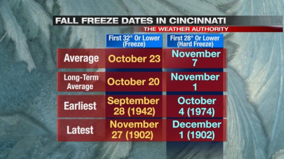
Frost does not necessarily mean the end of the growing season, but frost can easily kill plants – especially if they are sensitive to cold. A freeze or hard freeze signals the end of the growing season for all seasonal vegetation. On average, the first freeze or hard freeze of the fall in Cincinnati occurs in late October or early November:
Note that a freeze has occurred as early as late September, and a hard freeze has occurred as early as early October.
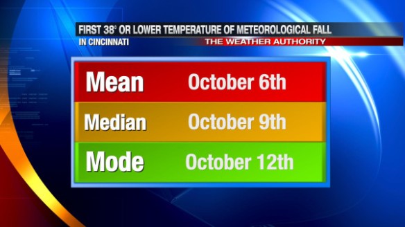
The averages and the range of dates can be helpful, but there are more than two ways to measure first fall frost dates. Statistically, the most common ways to measure the “center” of a set of data are involve taking the mean, median, and mode. Simply put, the “mean” is the average, the “median” is the “center” value in the chronological list, and the “mode” is the most common value occurring in the list. For example, if we assume the first fall frost occurs when the temperature (measured 2 meters above the ground) drops to 38°, here are the mean, median, and mode dates for the first fall frost in Cincinnati:
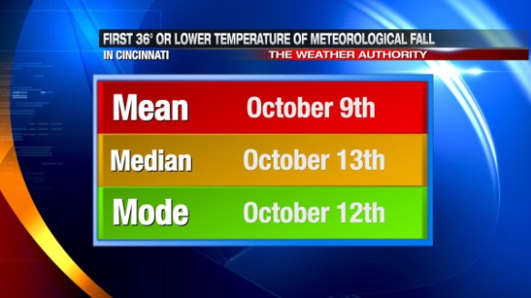
If we assume the first fall frost occurs when the temperature drops to 36°, here are the mean, median, and mode dates for the first fall frost in Cincinnati:
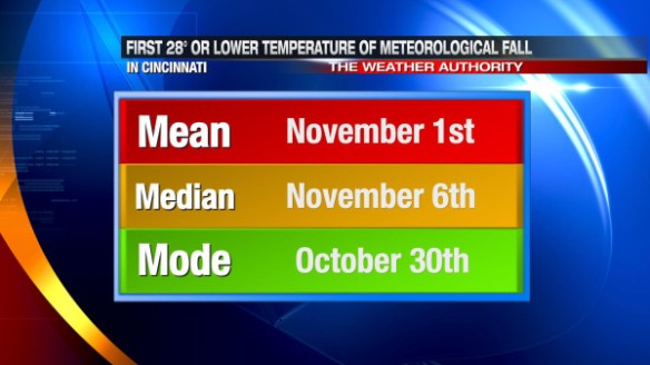
These averages are based on data from 1871 to 2013. What is the mean, median, and mode date for our first freeze?
The mean, median, and mode dates for the first hard freeze in Cincinnati are:
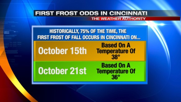
Historically and statistically, if you assume the first fall frost occurs when the temperature drops to 38°, there’s a 75% chance we get our first frost by October 15th. The date slides about one week later if you use 36° as a temperature:
At this point, the cold blast coming in the wake of Friday’s cold front does not look to bring widespread frost to the Tri-State. Longer-range computer guidance suggests temperatures will warm back near or above average by the middle part of next week. Beyond the first full week of October, guidance suggests waves of cold air will gradually push southeast from southern Canada. While the first of these series of cold blasts may not bring frost, reinforcing shots of cold, Canadian air in October suggests our first fall frost will come very close the historical average date.

