Was Summer 2015 In Cincinnati More Humid Than Average?

Answering the question “How humid was it this summer?” requires an understanding of the dewpoint. The dewpoint is a temperature that indicates an absolute measure of how much moisture there is in the air. Knowing the dewpoint is helpful for gauging how humid Cincinnati was on a particular day or for a particular period of time.

There are extensive weather records for temperatures and precipitation in Cincinnati back to November 1, 1870. Reliable, hourly dewpoint records for Cincinnati, however, only go back to 1938. This period of record, however, is more than sufficient to create 30-year averages (1980-2010); these averages compared to the average dewpoint for each month this summer will give us an indication of how humid this summer was and when.

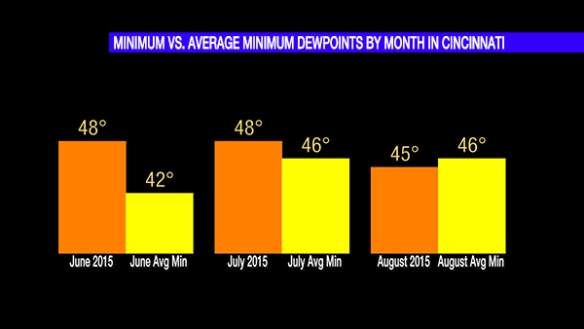
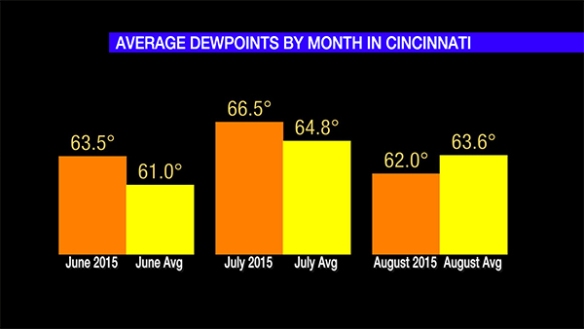
Here’s a comparison of average dewpoints by month in Cincinnati compared to the monthly average:

sep2-dewpointsmonth2

This graph shows June 2015’s average dewpoint was higher than the 30-year average, July 2015’s average dewpoint was higher than the 30-year average, and August 2015’s average dewpoint was lower than the 30-year average. June 2015 and July 2015 were both more humid than average, but August 2015 was not.

It is not uncommon to have dewpoints ranging from the 40s to 70s during June, July, or August. The dewpoint peaked in the 70s in June, July, and August; this peak, however, was well short of the all-time records (back to 1938) for each month near or above 80°:

sep2-maxdewpoints2

We expect the maximum dewpoint of each month to be below the record, and that was the case for each month this summer. The maximum dewpoint we saw June was on the average, just above average in July, and just below average August:

sep2-maxdewpointsaverages2

The minimum dewpoint we saw in June well above average, above average in July, and below average in August:

sep2-mindewpointsmonth2

All of the graphics above suggest that June and July dewpoints were – more often than not – above average, but August dewpoints were generally below average.

A Lack Of Heat In Summer, August 2015

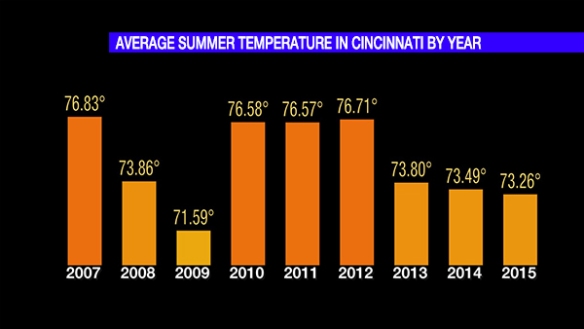
Meteorological summer 2015 has come to an end, and it was 34th coolest, 112th warmest, and 17th wettest on record in Cincinnati. This summer finished 3.78″ below average for rainfall and about 0.74° below average for temperature. Based on the departure from average, this summer was actually cooler than summer 2013 and summer 2014 combined. Based on average temperature, this summer was the coolest in Cincinnati since 2009:

sep1-avgtemp

The average summer temperature for 2015 would be higher had it not even for a cooler than average July and August. July and August finished 0.49° and 2.59° below average, respectively. This may not seem like a lot, but remember the the average temperature is the average of the daily high and daily low averaged over the entire summer.

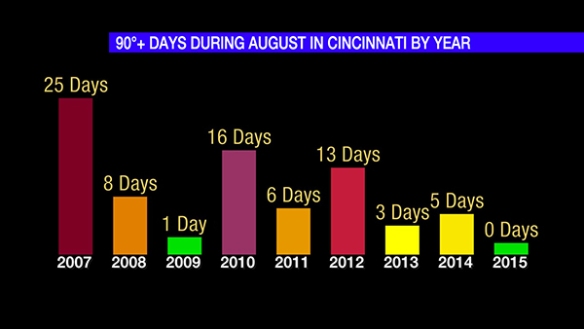
On average, there are 7 days each in both July and August with a high temperature of or above 90° in Cincinnati. So far this year, there have only been 9 90°+ days in the Queen City (5 in June and 4 in July):

sep1-90days

Cincinnati averages 21 days each year with a high temperature of or above 90°. The likelihood of hitting 90° drops very quickly late in September and is extremely low in October. Cincinnati will likely hit 90° at least once in the week ahead before cooler air returns.

It is unusual to not hit 90° at least once during August in Cincinnati. Even during a much cooler summer (2009), Cincinnati still managed to hit 90° once:

sep1-90augustdays

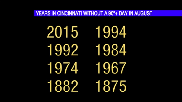
Since official records for Cincinnati began on November 1, 1870, there have only been 8 Augusts where the temperature failed to reach 90° at any point during the month:

sep1-no90saugustyears

I hope you enjoyed the break in heat during August. High temperatures will consistently be in the upper 80s to around 90° through early next week. Cooler air will return to the Tri-State by mid-September.

Understanding The Difference Between Dewpoint And Relative Humidity

The dewpoint is not the relative humidity. The relative humidity is not the dewpoint. Unless you are a meteorologist, you could go your entire life without knowing the relative humidity again. Meteorologists use relative humidity for forecasting clouds and for specific fire weather purposes…and that’s about it. If you only follow one of these two variables, choose dewpoint.

The dewpoint is an absolute measure of how much moisture there is in the air. The higher the dewpoint is, the more humid it is. When the air temperature cools to the dewpoint, the air comes saturated. Any dewpoint above 60° suggests it is humid outside; a dewpoint of 70° or higher means humidity is oppressive.

The relative humidity is different than the dewpoint. The relative humidity describes the relationship between the temperature and the dewpoint. More specificially, the relative humidity is the amount of atmospheric moisture present relative to the amount that would be present if the air were saturated. If the temperature is close to the dewpoint, the relative humidity will be high; if the temperature is far away from the dewpoint, the relative humidity will be low.

The relative humidity does not describe how humid the air is; the dewpoint does. The relative humidity can be 100% in the winter when the air is far from humid. Likewise, the relative humidity can be below 50% when it is very humid outside.

Let’s look at the relationship between the temperature and dewpoint and how it affects relative humidity. If the temperature and dewpoint are equal to each other, the relative humidity is 100%. For example, if the temperature is 65° and the dewpoint is 65°, the relative humidity is 100%:

aug12-65t65td

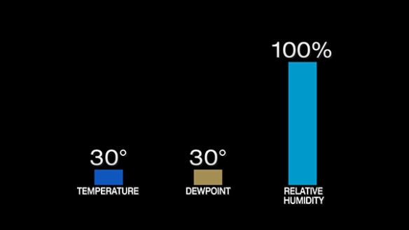
If the temperature is 30° and the dewpoint is 30°, the relative humidity is still 100%:

aug12-30t30td

Regardless of what the temperature and the dewpoint are, if the two are equal, the relative humidity is 100%. The relative humidity can be 100% on a humid summer morning or on a very cold winter day.

Let’s go back to the first scenario. Suppose the temperature rose from 65° to 80° on a summer day, but the dewpoint remained at 65°. Because the difference between the temperature and dewpoint increased, we expect the relative humidity to decrease. In fact, it dropped to 60%:

aug12-80t65td

Did the air become less humid? The answer is no. The dewpoint did not change, but the relative humidity dropped significantly; because the dewpoint is over 65°, however, it is humid. In fact, you didn’t even need to know the relative humidity to know whether the air became less humid or not; you just needed to know if the dewpoint rose or fell.

Suppose later that day the temperature kept rising, the dewpoint didn’t change, and the relative humidity fell:

aug12-90t65td

Did the air become more humid or less humid? The answer is neither. The dewpoint did not change, so the air is not more or less humid.

As an aside, the air may feel more humid when the temperatures rose through the day (even when the dewpoint did not). This apparent temperature – called the heat index – rose because the temperature increased. The heat index is only calculated between the temperature is greater than 80° and the dewpoint is greater than 54°.

Let’s make another change. Suppose the temperature did not rise again, but the dewpoint and the relative humidity both increased:

aug12-90t70td

Did the air become more or less humid? The dewpoint rose, so the air became more humid. The relatively humidity rose only in response to the dewpoint rising; because the difference between the temperature and dewpoint went down, the relative humidity increased.

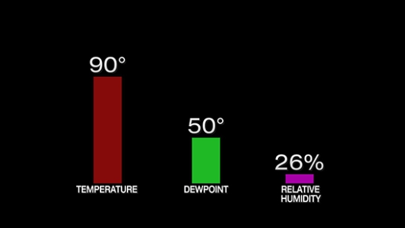
It’s time for one more change. Suppose the temperature of the air remained the same, but the dewpoint and relative humidity dropped:

aug12-90t50td

The air became far less humid because the dewpoint dropped 20°! The relative humidity dropped only because the difference between the temperature and the dewpoint increased.

In summary, the dewpoint is an absolute measure of how much moisture there is in the air. The relative humidity does not tell you how humid the air is; the dewpoint does. The relative humidity describes the relationship between the temperature and dewpoint. The relative humidity can drop and fall rapidly through the day even if the dewpoint remains the same. Despite “humidity” in its name, relative humidity is not a good judge of humidity as you feel it; it is a measure how far apart the temperature and dewpoint are.

Don’t fall into the relative humidity trap! Relative humidity almost always rises and falls more quickly than the dewpoint. Stick with the dewpoint; it is your absolute guide to absolute humidity!

More Storms Than Usual This Month, Summer, And Year?

Many in the Tri-State feel that this has been an abnormally stormy month, summer, or year. Perhaps it is the intensity of the rain, the frequency of the storms, or the lack of days with abundant sunshine that have people thinking there have been more storms than usual this year.

I keep a database of Severe Thunderstorm, Tornado, and Flash Flood Warnings for the area. The records go back to when the National Weather Service Forecast Office in Wilmington, Ohio first began issuing warnings in 1995. While we are not halfway through the month of August, the Tri-State Tornado and Flash Flood Warnings counts (from January 1st to August 31st) are below the averages and records for the same time period. The Severe Thunderstorm Warning count is above average:

aug10-warnings

These numbers suggest this has been a stormy year in some ways, but not in all. Many forget how stormy 2011 was. 2011 was also the wettest year on record in Cincinnati (with yearly records dating back to 1871).

Many have said that this August has been abnormally stormy. One way to measure this is by comparing the August Severe Thunderstorm Warning count from one August to others:

aug10-augsvrs

On average, there 12 Severe Thunderstorm Warnings are issued in the Tri-State each August; so far in 2015, 17 have been issued. By this measure, it has been a stormy August, but more warnings were issued in 2007 and 2010. It is worth noting that August 2015 has not yet ended, so that count is not final.

Has this been an abnormally stormy summer? If you compare the Tri-State Severe Thunderstorm Warning count from June 1st to August 31st, there have only been 3 years since 2007 with more warnings:

aug10-summer

On average, 59 Severe Thunderstorm Warnings are issued in the Tri-State each summer (June, July, and August combined). While we are ahead of the average, we are unlikely to break the summer record of 103 warnings set in 2008.

For all intents and purposes, 2013 and 2014 were somewhat quiet severe weather years. No tornadoes were confirmed in the Tri-State during 2013, and 5 were confirmed in Tri-State during 2014. For perspective, the yearly average (1950-2014) is roughly 3 tornadoes. Flash Flood and Tornado Warning counts were below the 1995-2014 average in both 2013 and 2014. The Tornado Warning count was below average in 2013. If you remember the last couple of years, 2015 is a stormy year. Calling 2015 “stormy” compared to 2011 or 2012 is a much harder case. There were 16 confirmed tornadoes in the Tri-State during 2012.

I’ve found that when people compare seasons, they often compare it to last year or the previous season. 2011 and 2012 were stormy years and – in many ways – stormier than 2015.

There are also dozens of ways to measure how stormy a period of time is. 2015 has been a stormy year for Brown County, where three flash flood fatalities occurred earlier this year. Those are the first storm-related deaths in Brown County since March 2, 2012. Where you live, what you see, or what you doing see influences your memory of storms.

A Sycamore Story: Putting A Weather Station On The Roof

Since I returned back home to Cincinnati in late 2011, I’ve been connected with Sycamore Community Schools in a lot of ways: through teachers, through friends, and by getting involved in district activities. Sycamore is a district with award-winning education, and Sycamore is working on some new initiatives to make sure students are better prepared for the workforce.

Before a weather station and camera network was created at Local 12, I spoke at a STEM (science, technology, engineering, and mathematics) meeting with Sycamore staff in 2012. I discussed the value of having a weather station at a school. First, the data collected by the weather station can be used in the classroom to teach math, science, technology, and computer programming. The data can also be shared with the National Weather Service and media to show current weather conditions; these data are especially important during active and severe weather.

Sycamore recent initiatives opened up an opportunity to put a weather station at Sycamore High School. With the backing of the district, the weather station arrived at the high school last week, and the installation began on Wednesday:

aug7-weatherstation

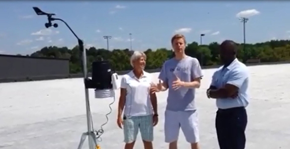
Mr. Chad Husting, a science teacher at the high school, Ashwin Corattiyil, the Dean of Students at the high school, and I set up the weather station on Wednesday. Mr. Husting was nothing short of MacGyver connecting the pieces together. He even came in Friday to secure the station’s pole and tripod!

The weather station is away from wind blocks and obstructions and also away from where animals and people can influence the measurements with it:

aug7-roofshot1

The wind speed and direction are measured at the top of the weather station, and rainfall and temperature measurement are taken in the black and white-colored units, respectively.

It is important that the station is positioned away from walls, buildings, and trees that can block the wind. That makes the roof a great spot!

aug7-roofshot3

Note the cinder blocks holding the weather station down. Derrick Richardson (assistant principal), Ms. Haverkos (high school science teacher), two custodians, Ashwin, and I put those there to make sure the station was secure (they did most of the work)!

aug7-weatherstation2

The weather station has a wireless connection to a console in the building. From the console, the data are uploaded to the Internet and to various sources:

aug7-wxstationconsole

While at the school, students will be able to see the data on the console, but the data will also flow to several places online, including:

http://www.weatherlink.com/user/sycamorehs
http://www.wunderground.com/personal-weather-station/dashboard?ID=KOHCINCI139
http://mesowest.utah.edu/cgi-bin/droman/meso_base_dyn.cgi?stn=E7726 (coming by mid-August)

This is an exciting time for Sycamore not just because I see a weather station on the roof but because students, staff, and the community benefit from having that data. Science teachers at Sycamore High School, including the ones listed above, seem to be very excited about this new teaching tool, and I’m hopeful that the success of this weather station is so big that it spreads to other schools throughout the district.

Ironically, Sycamore High School is across the street from a neighborhood heavily damaged by an F4 tornado back on April 9, 1999. Those who have lived in Blue Ash, Montgomery, and Symmes Township for years know that a simple weather station is more than just education; it’s safety.

What Happened Near New Vienna, Ohio Friday Afternoon?

It’s not often I get to go out and survey storm damage. I’m usually in a studio under bright lights. When storms hit today, the newsroom dispatched me into the field. Initially, I saw tree damage along Pausch Road near Leesburg, Ohio:

leesburg

This photo was taken looking northeast and all of the downed trees are pointing towards the southeast, where radar suggested the winds from the storm were pointing to. In nearly the same spot and facing the opposite direction, damage to barns suggested a northwest wind when it occurred. There was siding in the field from the leftmost barn pictures just southeast of the barn:

leesburg2

With all of the damage fanned out in a uniform direction, this suggested straight-line winds caused this damage.

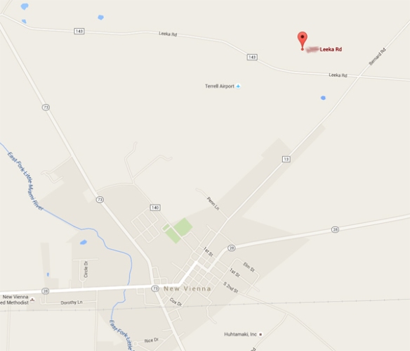
Shortly after we left the scene to head home, the newsroom directed us to a damaged home north of New Vienna, Ohio. Here’s the approximate location of the house relative to New Vienna:

jun27-leeka

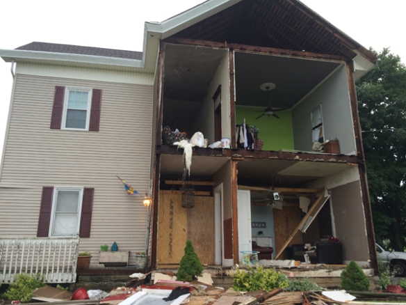
Imagine what I felt arriving the scene and seeing this:

jun27-house

Whoa. What could cause this? I immediately went into investigation mode. Here’s a wide shot of this house and the yard around it:

june27-pana

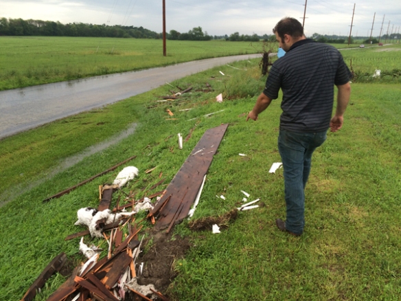
Notice anything, even that this resolution? Most of the debris is to the left of the house. With this photo looking southeast, most of the debris is on the east or southeast side of the house, including all of this debris along the road:

jun27-debrisroad

Closer to the home, I found this wood board driven into the ground:

jun27-board

Whoa. That’s some force. The home owner (pictured above) is actually an electrical engineer at General Electric. He was thinking like I was; he wondered how there could be all of this debris so far away from the house, especially east of the house. The wind was coming from the northwest at the time; if damaging straight-line wind was the cause of this damage, why was there so much damage to the east of the house (including large, heavy parts of the walls)? In addition to the debris field, that board driven into the ground suggested to me this was a tornado.

After we shot our video at the house, we drove through New Vienna (north on State Route 73); there was a lot of tree damage there:

jun27-nvdamage

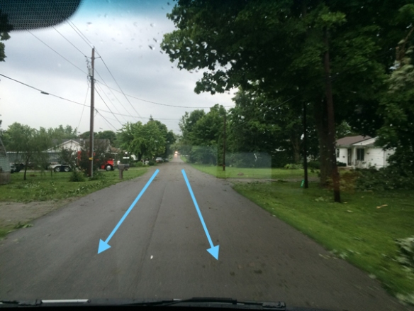
I did not see any structural damage, and all of the tree damage seemed to lean towards the south, east or southeast. The alignment of buildings and tree along the road reminded me of the Venturi Effect, possibly explaining how winds were accelerating through the town. More on the Venturi Effect is here: http://www.tech-faq.com/venturi-effect.html. In other words, winds – moving northwest to southeast through the town, or basically down S.R. 73 – were accelerating or at least traveling through the town like this:

jun27-nvtown

This damage appears to be caused by straight-line winds. As I drove home, I had a visual of what the radar data might look like. While I had looked at radar briefly in real-time as the storm moved through Highland County, I had not looked at the radar data in detail.

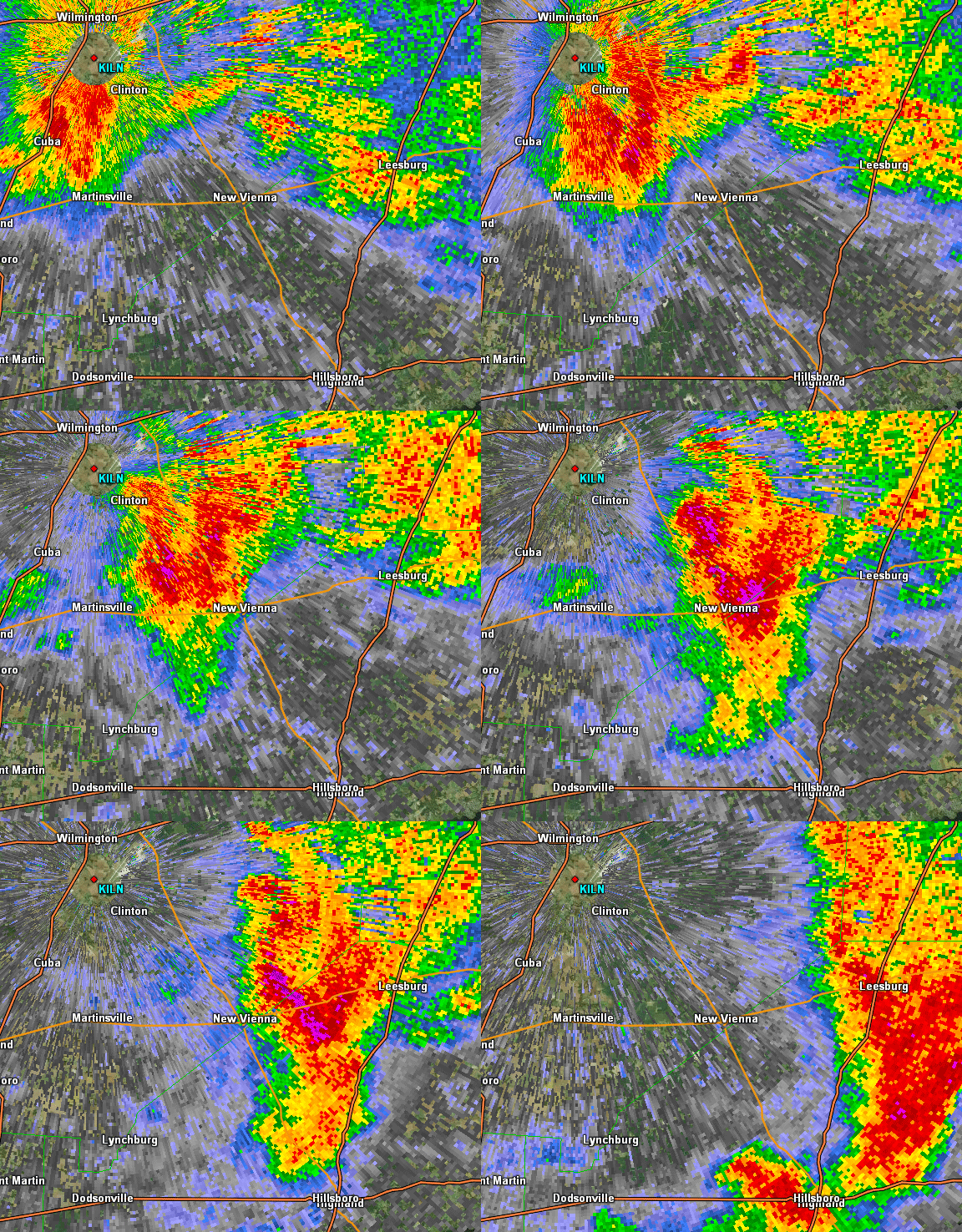
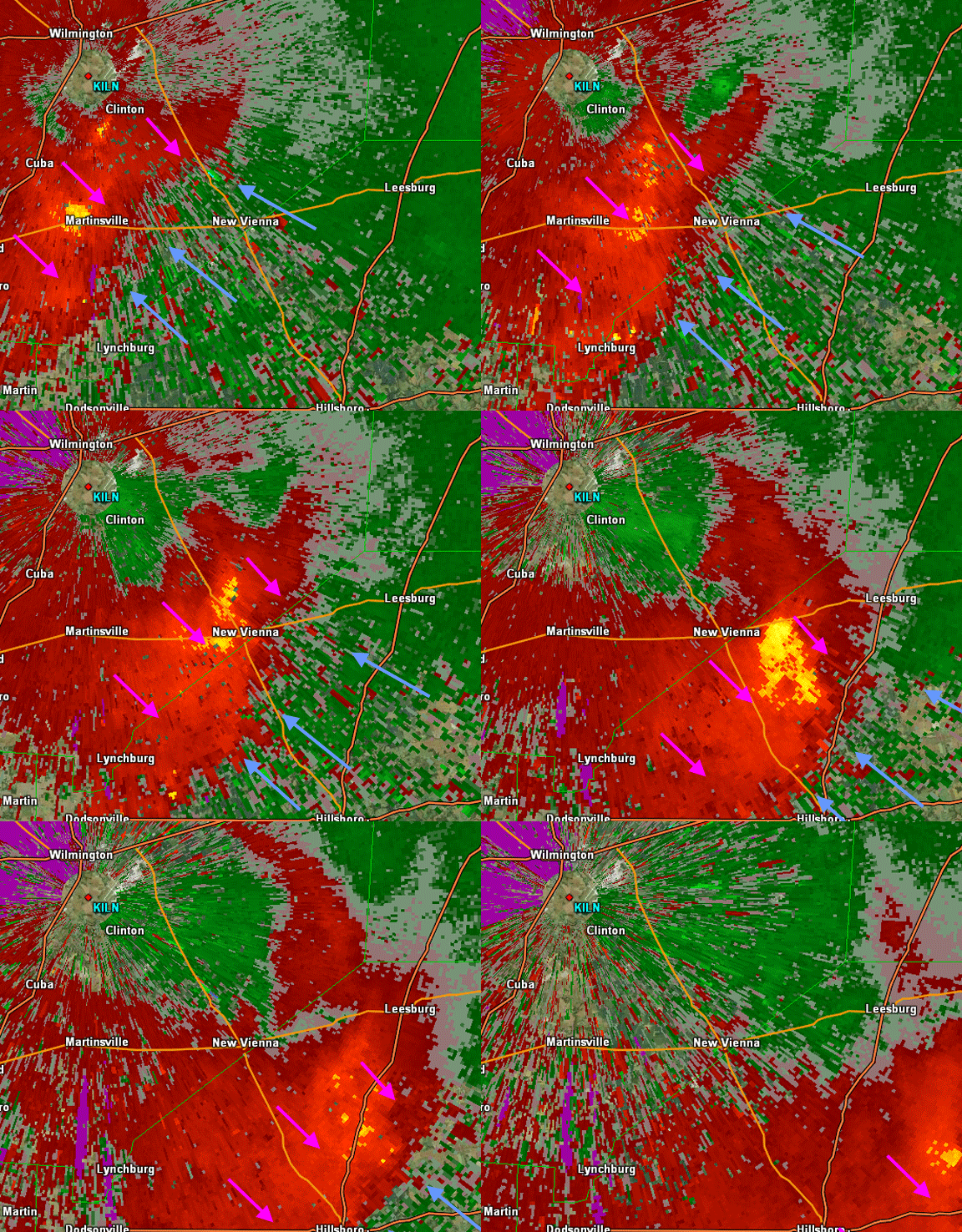
Here is the radar loop from 3:04 to 3:49pm for this Highland County storm:
jun27-reflectivity

Here is the storm relative velocity (the Doppler part of Doppler radar or how the winds are moving relative to the radar [minus the motion of the storm to see rotation] in Wilmington, Ohio) loop of this storm from 3:04pm to 3:49pm:

jun27-srm

From the radar’s lowest scan angle, red colors are winds moving away from the radar, green colors are winds moving towards the radar, and yellow colors are severe winds moving away from the radar. So the overall wind flow relative to the radar looked like this:

jun27-srmlabel

There’s no strong rotation here. Radar suggests mainly outflow winds. But there’s more! Let’s look specifically at the radar snapshot around 3:15pm:

jun27-reflectivity315

There’s no hook echo or strong inflow notch. Let’s look at the base velocity data for the same area:

jun27-bv315

Winds were moving away from the radar near New Vienna at the time damage occurred. Normally, strong winds towards and strong winds away from the radar are close together near a tornado. So there’s no tornado right? Not so fast. The magnitude of the wind speeds near New Vienna matter:

june27-bv315label

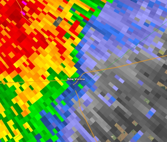
See how wind speeds over New Vienna are stronger than where the blue arrow is? Imagine a pinwheel facing the sky just north of New Vienna. Which way would it rotate? Counter-clockwise…like most tornadoes do. If you’re having a tough time visualizing this, see what normalized rotation looked like:

jun27-nrot

The green area shows significant counter-clockwise rotation based on raar; in other words, this is where radar is detecting rotation and the possibility of a tornado.

The National Weather Service in Wilmington is responsible for determining if damage was from straight-line wind or a tornado. I don’t know if they will survey this Saturday. Based on the damage I saw, the Leesburg damage looks to be from straight-line wind, but the New Vienna damage is more complicated. After seeing it with my own two eyes, the damage north of New Vienna looks tornadic, but the damage in town is a close call.

We will see what the verdict is from the NWS!

Remembering The Harrison Area F4 Tornado 25 Years Ago

When you think of Tri-State tornadoes, you may think of March 2, 2012 or April 9, 1999. If you’ve lived in the Cincinnati area for a while, you may also remember April 3, 1974. The tornadoes of June 2-3, 1990 are often forgotten because there were no fatalities from tornadoes that night. There were, however, roughly 40 injuries in southeastern Indiana and southwestern Ohio during the event; all of these injuries came from an F2 tornado extending from Ripley to Dearborn County and from an F4 tornado extending from Dearborn to Warren County:

jun2-tracks

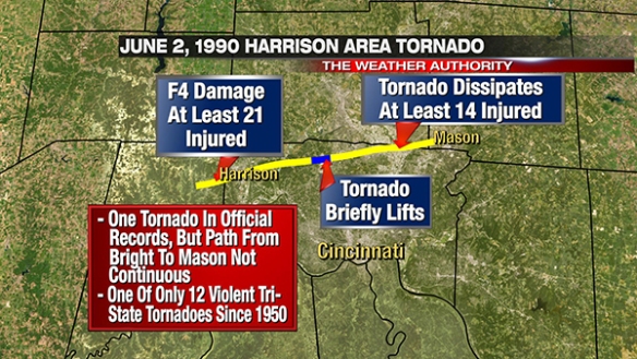
The highest rated tornado in the Tri-State that night was an F4 that went through Harrison, Ohio and also caused damage up to Mason. This tornado began two miles west of Bright, Indiana and continued into northwestern Hamilton County, where 32 homes and five businesses were destroyed. Two 18-inch, 75-foot long, 5/8″ steel beams designed to withstand winds up to 250mph were twisted to the ground at a restaurant in Harrison. The tornado continued into southern and southeastern Butler County where 19 homes and 4 mobile homes were destroyed. 58 homes, 22 mobile homes, and five apartment buildings were damaged. The tornado ended about 1 mile southwest of Mason, Ohio in Warren County.

A little known fact about the Harrison area tornado is that the path of the tornado is not continuous despite official records listing the damage from Bright to Mason as one tornado. The tornado briefly lifted near New Baltimore, Ohio and settled back to the ground in Colerain Township near Pippin Road. While the tornado lifted, the path’s interruption was brief enough to count as one tornado per NWS directives. Current NWS directives (specifically, NWS Directive 10-1605) state that if a tornado’s path is interrupted for more than 2 miles OR more than 4 minutes, the tornadoes will be rated separately. This NCDC website suggests “a tornado that lifts off the ground for less that [sic] 5 minutes or 2.5 miles is considered a separate segment. If the tornado lifts off the ground for greater than 5 minutes or 2.5 miles, it is considered a separate tornado.” Official NWS records (from the National Climatic Data Center) suggest the tornado lifted near New Baltimore, Ohio at 10:10pm EST and touched down again in Colerain Township, Ohio at 10:14pm EST. While close to being two separate tornadoes, official records list the damage from Dearborn County to Warren County as one tornado. It is unclear to me which definition is correct and/or was the correct definition at the time. Here is a map showing the tornado’s path on the evening of June 2, 1990:

jun2-harrison

The F2 tornado that affected Ripley and Dearborn County that night produced 3 injures and caused mainly tree damage. The Hopewell Church in western Ripley County near Holton was, however, destroyed.

Radar images of this event are of poor quality, but it appears that a cyclic supercell was responsible for the damage extending from Holton to Mason. Other, weaker tornadoes were confirmed in Boone, Clermont, and Clinton County that night.

No one died in the Harrison area tornado of June 2, 1990. Including this one, there have only been three violent (F4, F5, EF4, or EF5) tornadoes in the Tri-State since 1950 that have not produced fatalities (the others being on April 3, 1974 and April 25, 1964).

Spring Frost And Freeze Dates In Cincinnati

As a Cincinnati native, I find it very surprising that so many people that live in the Tri-State – including many natives – that don’t expect the temperature to drop near freezing in late April or early May. Hope springs eternal? Perhaps. While many cheer for warmth all spring, flowers almost always start blooming before the last 32° or 36° temperature of the cold season comes.

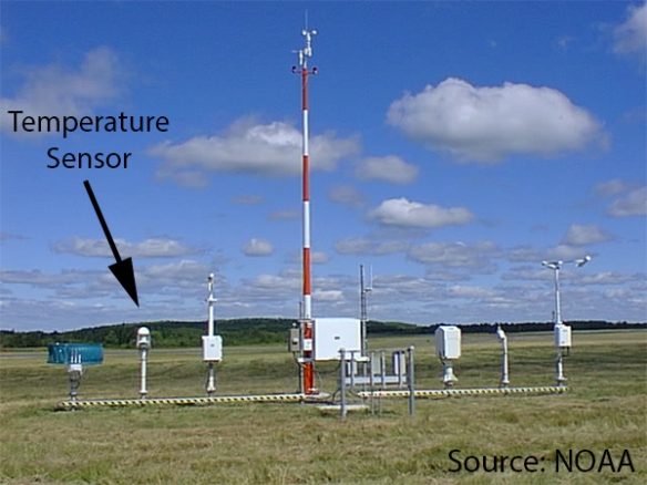
While a temperature to or below 32° is scored as a freeze, frost can develop at various temperatures. The temperature at eye-level can be 40°, but there can still be frost at your feet. At local airports (where the meteorological standard is used), the temperature is measured 2 meters (or roughly 6.5 feet) above the ground:

sep28-asos

Because relatively cold air sinks and relatively warm air rises, the temperature of the air below the temperature sensor’s height is likely below the temperature of the air at the temperature sensor’s height. If a plant was planted below the temperature sensor at an airport, it may be damaged or killed on a morning where the temperature sensor above it recorded a low of 35° to 40°. This is why Frost Advisories are issued when the temperature drops into the mid and upper 30s.

When does history suggest you’ll be able to plant your flowers and completely forget (well, virtually) about a killing frost or freeze? A sign at Natorp’s Nursery Outlet in Mason says:

apr23-frostfree

…but historical records suggest otherwise!

The latest freeze of the spring in Cincinnati typically comes in April, but we have gone the entire month of April without a freeze and had to wait until late May to get the last freeze of the season:

apr23-freeze

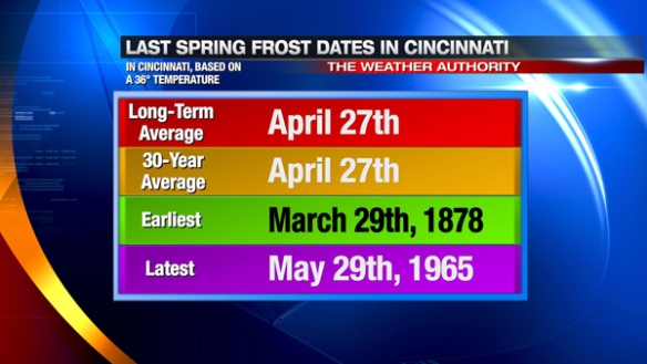
A freeze (hitting 32° or below) will kill plants very sensitive to the cold and severely damage plants sensitive to the cold. A frost, however, will damage – in full or part – plants sensitive to cold. Using a temperature of 36°, Cincinnati’s last frost of the spring typically comes in late April; historically, it has come as early as late March and as late as late May:

apr23-frost

Mother’s Day is usually a save bet for planting flowers; more specifically, looking at the forecast on Mother’s Day to make sure the temperature won’t drop below 40° is a save bet for planting flowers. Since 1871 (not including 1872 because those spring records are missing), the historical odds of the last spring frost (using a temperature of 36°) occurring during May in the Queen City is 32.8%. In other words, the last frost of the year comes before May begins two out of every 3 years.

So…back to the big question…when does history suggest you’ll be able to plant your flowers and completely forget about a killing frost or freeze? Based on records back to 1871, you’ll have to wait to late May to completely avoid a freeze and June 1st to avoid frost:

apr22-latest

Happy planting! But seriously, wait until Mother’s Day.

Why Local Weather Station Data Is Important

All weather is local.

Sure, patterns and cycles in the atmospheric impact the oceans, the patterns and cycles of the ocean affect the atmopshere, the larger scale features affect the smaller-scale features, and the smaller-scale features can effect the large scale features. But – ultimately – you care about the current conditions and the forecast for where you live. Not a state to the west, not a county to the west, not a city to the west, but where you live. And that’s why all weather is local. As a meteorologist, you must think globally and forecast locally.

A forecast for where you live is more likely to be accurate when we know the current conditions where you live. As George Carlin said, “I don’t know anybody who lives at the airport.” While reliable instruments for measuring atmospheric conditions – including the temperature – are often located at airports, the weather must also be understood away from airports. There are several airports in the Tri-State, but there are hundreds of thousands of people in our area that don’t live within 5 miles of an airport (and weather conditions can be dramatically different over a 5 mile span).

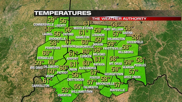
One of the most common ways to showcase local weather conditions is a temperature map. Rain or shine, people always care about the temperature. Here’s a typical temperature map you’ll find on Local 12:
apr14-blog-alltemps

Regardless of the source, it is incredibly likely that your community or one nearby is represented on this map. Nearly all counties are represented, and some counties have 2 or 3 temperatures listed. It is impossible to get all of the weather stations in the Tri-State on this map; this is about as full as it can get.

But what is the source of this temperature data? The simple answer is: “there are multiple sources.” The more complex answer is below.

There are eight airports in the Tri-State that have an Automated Airport Weather Station (ASOS) or Automated Weather Observing System (AWOS) that share data with the FAA directly. These observations are taken under strict standards; for example, temperatures are measured 2 meters above the ground and wind speeds are measured 10 meters above the ground. These sites also report the visibility. Outside of maintenance and occasional power outages, these sites share observations 24 hours a day, 7 days a week, and 365 days a year:

apr14-blog-asostemps

While those sites are very reliable, Remote Automated Weather Station (RAWS) sites are also run 24 hours a day but report just basic weather conditions (temperature, winds, dewpoints, etc.). These RAWS sites are run by the U.S. Forest Service and Bureau of Land Management to monitor wildfire potential in and near national forests. These sites always report once or twice an hour with no exceptions (including special reports for strong winds or severe weather). There are three RAWS sites in the Tri-State (Crittenden, Big Oaks Refuge, and Shawnee National Forest):

apr14-blog-rawstemps

The Shawnee National Forest RAWS is not displayed to make room for West Union’s temperature (see below).

Roadway Weather Information System (RWIS) sites are operated by state transportation departments, including the Indiana Department of Transportation, the Ohio Department Of Transportation, and the Kentucky Transportation Cabinet. These sites measure atmospheric conditions as well as pavement conditions (wetness, temperatures, etc.):

apr14-blog-rwistemps

The Kentucky Mesonet is the official climate network of Kentucky and is operated by Western Kentucky University. Most counties in Kentucky have a site, and they are positioned to measure temperatures, wind speeds, rainfall amounts, and dewpoints in areas away from airports and other major observing sites:

apr14-blog-kymesonettemps

The Kentucky Mesonet site in Burlington is not shown to make room for the Cincinnati/Northern Kentucky International Airport and Union weather station data.

The temperature map is pretty full with temperatures already, but there are several communities we have left out so far. To fill in the gaps, we use personal weather station data. More specifically, owners of a personal weather station (that they bought) have configured their weather station software to share data with us. With the exception of Lebanon and Falmouth, the data shown on Local 12 from these sites come from personal weather stations:

apr14-blog-othertemps

Temperatures listed for Falmouth and Lebanon come from the AWOS at the Gene Synder Airport and the Lebanon Airport, respectively. These observations, however, are not sent directly to the FAA and the NWS through a certified channel; they are sent to us through a secondary data stream NOAA operates called MADIS, or the Meteorological Assimilation Data Ingest System.

Remember, the temperatures on the maps above are just the ones that fit on the map. There are dozens of other sites in our area that we monitor.

With ASOS, AWOS, RWIS, RAWS, and Kentucky Mesonet sites in the Tri-State, why is there a need for personal weather station data? It all comes full circle: all weather is local. Personal weather station data shows us small-scale wind, precipitation, and temperature changes. These personal weather station stations can and have verify Severe Thunderstorm Warnings and Flash Flood Warnings. Also, higher-resolution, modern computer forecast models analyze local weather station data and may incorporate the data into the model.

If you own a personal weather station, please consider sharing your data with the Citizen Weather Observer Program. If you use software to upload your weather station data online, odds are good that you can share your data with CWOP. Step-by-step directions for sharing data from popular weather stations and their software to CWOP can be found here: http://www.srh.noaa.gov/epz/?n=cwopepz. Many towns and cities don’t have a weather station reporting at this time.

If you have any questions about which weather station to buy or how to share data with CWOP, please don’t hesitate to ask in the comment section of this post.

Thunderstorm Myths

There are numerous misconceptions and myths about thunderstorms. “Lightning only strikes tall objects,” “people struck by lightning carry an electrical charge,” and “it is okay to showers during a thunderstorm” are some of the common misconceptions. I am not here to discuss these; instead, I want to highlight some of the challenges meteorologists face during active and severe weather. While reports are valuable to us, there are a lot of beliefs about storms and reporting storms that are not true, such as:

apr13-blog-myth1

While radar is a powerful tool, it is not a pair of eyes. Radar can but often does not confirm tornadoes. Radar suggests where damaging straight-line winds are likely, but it doesn’t confirm them. Radar data suggest where heavy rain has fallen, but it doesn’t replace what a rain gauge measures. Simply put, radar, models, satellite, and weather balloon data are great, but it doesn’t always verify the conditions where you live. In fact, your report is more important than anything a meteorologist can access at his or her fingertips. Please don’t assume someone else has reported what you are seeing because you may the only one seeing what you are seeing. Always report out-of-the-ordinary weather.

apr13-blog-myth2

Thank you for your report. Seriously! We need to know what you are seeing! Radar doesn’t always tell us the story. When you submit your report, however, please be specific about what you are seeing and where. Where are you located? Are you in a town, and how far/what direction are you relative to that town? A photo of hail or damage is great, but a photo with a detailed description of where you are (i.e. “I’m 2 miles west of Oxford, Ohio”) is FAR more helpful. In addition to knowing where you are, I want to know what you are seeing specifically. If you are seeing hail, how large is the hail compared to a coin? Why do I ask this? Because coins are all the same size; a quarter in California is the same as a quarter in Ohio. I need to know how big your hail is compared to something absolute in size. I don’t know how big your hand is. I don’t know how big your finger is. I do, however, know how big a golf ball is.

Also, please let me know what time severe weather occurred. Sending me a photo at 5:30pm of damage that occurred at 5:25pm is helpful, but sending me a photo at 5:30pm of damage that occurred at 2:30pm is not as helpful, especially if there are numerous rounds of storms; I don’t know what storm likely caused the damage unless you can confirm when the damage occurred.

apr13-blog-myth3

You might. If you’re seeing a violently rotating cloud extending from the base of a thunderstorm that’s connected to the ground, you are seeing a tornado. If you’re not seeing this, you’re probably not seeing a tornado. You may be seeing a tail cloud, a funnel cloud, a wall cloud, or another type of cloud. After going through spotter training, you’ll know the difference between these types of clouds. There are a lot of tornado look-alikes. There’s actually a “Scary Looking Cloud Club.” While these clouds may look like tornadoes, they are not.

apr13-blog-myth4

I am sorry. I really am. I don’t want to have to interrupt your program to tell you there is a threat for damage. I don’t want to cut into your favorite show to tell you there may be a tornado coming towards you or one of your neighbors. But if it’s a life threatening situation, I have to cut into your program. It’s not just a standard set by television station managers, but it’s also the right thing to do.

I understand you may not be in the warning, but someone nearby is; they deserve the warning just as much as you do should your town been placed in the warning. Please understand that my job – ultimately – is to make sure you stay safe. If you’re going to see severe hail, severe winds, or a tornado, you not only deserve to know, you should want to know. Big Brother, Survivor, the Olympics, the World Series, the NBA Finals, or any other program is not as important as a meteorologist telling you that you or your stuff is in danger.