No Snowflakes In Cincinnati So Far This Season

While you may have seen flurries at some point this fall, there have been no flurries or snow showers reported in Cincinnati (at the International Airport, where official records are kept) since summer ended. If you’re thinking it is unusual to make it to December 1st without any snow, you’re right.

In the last 100 years (since 1915), the first flakes of the season (whether the snow accumulates or doesn’t) were most commonly observed in the first 10 days of November, although it was not uncommon for the first flakes of the season to fall in mid to late November or late October:

dec1-blog-byyear

There have only been 7 years since 1915 where the first snow flakes of the fall came after December 1st; the most recent year that this happened was in 1998 (which is also the record latest):

dec1-blog-latest

Before 1915, trace amount of snow were not included in official Cincinnati weather records. In other words, if snow fell before 1995 and the accumulation was under 0.1″, the daily snowfall amount was listed as “0.0” not “trace.”

Official snowfall records for Cincinnati date back to 1893, so we have the dates when the first accumulating snow of the fall or winter occurred for the last 119 years (this seasons’ first accumulating snow has not yet occurred).

Of these 119 years, the first accumulating snow (0.1″ or more) of the fall or winter in Cincinnati most commonly occurred between November 20th and 30th:

dec1-blog-accumyear

The first day of the season with accumulating snow has only come on or after December 1st 39 of the last 119 and after December 1st 38 of the last 119 years. The first day of the fall or winter with any snow (accumulating or not) is usually not the first day with accumulating snow; in the last 100 years, there were only 21 years in Cincinnati where the first day with any snow was also the first day with accumulating (0.1″ or more) snowfall. On average (1893 to 2014), 1.2″ of snowfall is recorded on the first day of the fall or winter with accumulating snowfall.

Using the mean and the median, the first flakes and first accumulating snow of the fall/winter season will come late this year (the dates have already passed).

Our only hope for seeing snowflakes in Cincinnati in the week ahead is Wednesday afternoon and evening. Long range forecast guidance suggests December will be warmer than average, so the likelihood for snow in the next 2-3 weeks is not high.

Perspective On The First Snow Of The Fall/Winter In Cincinnati

Since summer ended, snowflakes have yet to fall in Cincinnati this season. Despite what you may may think, it is unusual to make it this far into the fall without at least flurries. In the last 100 years, there have only been 31 years where the first snowflakes of the fall or winter fell after November 16th (today’s date). Accumulating snow, however, does not usually occur in Cincinnati before November 16th; in the last 145 years, the first day with accumulating snowfall came before November 16th roughly 34% of the time (49 of those years).

Some computer guidance suggests flurries will mix with rain this weekend. I am intentionally vague on the timing because this morning’s GFS model paints rain showers with some flurries Saturday morning and afternoon in the Ohio Valley, while this morning’s ECMWF model is suggests a better chance for flurries Saturday afternoon and evening. Notice the potential for accumulating snow of 1″+ for parts of the Great Lakes and northern Ohio Valley this weekend:

nov16-snowfall

As I highlighted above, we are due for our first snowfall of the season. From 1915 through 2014, the first date of the fall or winter with ANY snow (whether it accumulated or not) is November 9th on average. The first flakes of the season have fallen as early as October 12th and as late as December 17th:

nov16-anysnow

Since 1870-1871, there has never been a winter without measurable snowfall or flurries in Cincinnati.

The first day with accumulating snow during the fall or winter in Cincinnati, on average, is in late November:

nov16-accumsnow

5″ of snow fell on October 19, 1989, the earliest day of the fall on record were accumulating snow occurred in Cincinnati. Meanwhile, the first day with accumulating snow during the winter of 1908-1909 came on January 12, 1909 (when 6.8″ was recorded). On average and based on records from 1870 through 2014, 1.3″ of snow accumulates on the first day of the fall or winter with accumulating snow.

On average, the first day of the fall or winter in Cincinnati with 1″ or more accumulating snowfall is December 15th. As you saw above, 5″ of snow fell as early as October 19, 1989 in the Queen City. The latest in the fall or winter where 1″+ of snowfall accumulated was March 5, 2015…just 3 days after the deadliest severe weather day in the Tri-State since official records began in 1950.

Everything You Need To Know About Tonight’s Severe Weather Threat

The risk for strong and severe storms is in play tonight, but this is a limited threat for severe weather. Much of the Tri-State is under a marginal risk for severe storms tonight according to the Storm Prediction Center:

nov11-3pmspc

The threat for severe storms will be higher along and west of I-75. Storms that sweep through the Tri-State tonight will be moving quickly, approximately 40-50mph from the west to the east.

Damaging straight-line wind is the main threat with the strongest storms tonight. The most likely time for severe weather to occur is between 11pm and 3am:

nov11-impacts

As I have mentioned for days, clusters of rain and storms will weaken as they approach the Tri-State from the west tonight. This morning’s computer forecast models suggest showers and storms will stay to our west through 7pm:

nov11-7pmradar

Clusters of rain and storms will move into the Tri-State late this evening and gradually most east of I-75 early in the overnight:

nov11-1amthursday

When you wake up and to head to work Thursday, showers will be widely scattered at best and focused east of Cincinnati:

nov11-7amthursday

Regardless of how strong storms are tonight, the wind will remain strong Thursday and Friday; wind tomorrow and Friday will be due to the strength of low pressure positioned to our northwest and not from storms. Here’s my latest thinking on wind speeds and wind directions through this weekend:

nov11-wind

While the threat for strong and severe storms is relatively low tonight, please stay alert for warnings. You are encourage to make sure your NOAA weather radio is programmed correctly and has fresh batteries this evening; fresh batteries will ensure that if your radio loses power from the A/C outlet, you will still be able to get warnings if you are sleeping.

An Update On Wednesday Night’s Severe Threat

The threat for severe storms is still very much in play Wednesday night for the Tri-State; however, that threat has dropped some in the last 24 hours.

The Storm Prediction Center has placed parts of southeastern Indiana and a small part of northern Kentucky in a marginal risk for severe storms Wednesday night:

nov10-spc

As of Monday night, nearly the entire Tri-State was in a slight to marginal risk for severe storms. The map above shows the risk for damaging storms has dropped, but strong storms and heavy rain still remain a possibility.

The threat for severe storms in the Tri-State will center between 10pm Wednesday and 3am Thursday. Damaging straight-line wind is the main threat, but it is not the only threat:

nov10-impacts

One computer forecast model shows a line or lines of rain and storms developing in the Mississippi Valley Wednesday night. Some discrete, rotating cells are possible over Missouri and Illinois tomorrow, as this model suggests:

nov10-7pmwednesday

This same computer model shows the line of rain and storms to our west early Wednesday evening weakening by the time they get close to Cincinnati:

nov10-1amthursday

While I expect the line of rain and storms to be better organized and less broken than this model suggests, there is a clear indication from the model that storms will weaken traveling east through the Ohio Valley Wednesday night.

One thing that has not changed is my thinking on wind following Wednesday night’s storms. The sustained wind Thursday and Friday in Cincinnati will be between 15 and 30mph with gusts up to 45mph possible:

nov10-wind

Winds will relax by this weekend. Please stay weather aware Wednesday night as storms move through the Tri-State. Even after storms pass, the wind will remain strong Thursday and Friday with a strong area of low pressure nearby.

What You Need To Know About Wednesday Night’s Severe Weather Threat

Wednesday night will be one of those times to be alert for thunderstorms and strong wind. Today is only Monday, so there is roughly 48 hours to adjust the forecast.

There is high confidence that the best threat for severe storms during this event will be to our west in the Mississippi Valley. The tornado, damaging straight-line wind, flooding, and hail threat all converge on Missouri, Illinois, western Kentucky, and northeast Arkansas. In the Ohio Valley the threat for severe weather will be maximized late Wednesday evening and in the very early morning hours of Thursday. Storms that develop to our west Wednesday afternoon will move east towards the Tri-State at 45 to 60mph; in simple terms, storms in the Ohio Valley Wednesday night will be fast movers.

There is moderate confidence that the threat for severe storms will gradually drop as storms that develop in the Mississippi Valley move east Wednesday night. Because there will be gradual decrease in the intensity of storms, severe storms remain a possibility in the Ohio Valley – especially west of I-75 – Wednesday night.

There is low confidence in the exact strength and timing of storms Wednesday night. While there is computer forecast model agreement at this time, models may give us adjustments on timing and how strong storms will be later this week.

Heavy rain and strong to severe wind are the main severe weather threats in the Tri-State Wednesday night:

nov9-impacts

Note the most likely time for strong or severe storms in the Tri-State is from mid-evening Wednesday into the early overnight Thursday. The tornado threat is non-zero, as is the threat for flooding. The hail threat is very low at this time.

The Storm Prediction Center has placed the Tri-State in a marginal to slight risk for storms Wednesday night, with the highest threat for severe storms being west of Cincinnati:

nov9-spc

With storms forecast to move from west to east Wednesday night, this map suggests storms will weaken as they sweep through the Tri-State.

The position of the jet stream is very important in severe weather forecasting this time of year. In the map below, the jet stream is in blue, and faster winds are in the dark blue color. Divergence aloft – in purple where air is rising – is centered to our northwest Wednesday night:

nov9-divergence

Because the best lift from the jet stream will be to our northwest, this will limit but not prevent the threat for strong storms. Note weaker divergence over Cincinnati Wednesday night, so at least some upper-level support is there.

Low-level shear – or the change of the speed and direction of the wind with increasing altitude – is also important for severe storm forecasts. Notice an abundance of speed shear over the Tri-State Wednesday night:

nov9-shear

More shear tends to support better organization to storms. In this case, there is plenty of speed shear but not a lot of directional shear; this suggests the tornado threat is limited, but damaging straight-line wind is a concern.

The wind about 5,000 feet above the ground Wednesday night will be very strong (about 80mph! in purple):

nov9-850wind

While not ALL of this wind will be transferred to the ground, this is a very strong wind. For the math buffs, these wind speeds are about 2 to 3 standard deviations above average. The threat storms will end Wednesday night, but strong wind is forecast Thursday and Friday (sustained between 15 and 30mph with higher gusts). Note the ribbon of strong wind focused to our north Thursday evening:

nov9-850wind2

Wind speeds will drop Saturday, and the wind will be light Sunday.

Be prepared for storms and strong wind Wednesday night! Even if storms don’t cause damage, winds may be strong enough to cause power outages.

What You Need To Know About Friday’s Severe Threat

As I mentioned in my last blog post, there is a secondary severe weather season in the Tri-State. There is often an increase in the number of tornadoes, Tornado Warnings, and Severe Thunderstorm Warnings during the fall as the jet stream strengthens and low-level moisture increases ahead of strong fronts. Late tonight and early Friday is one of these cooler-season opportunities to see strong to severe storms.

The risk for severe storms late Thursday and early Friday is low, but it should not be ignored. The Storm Prediction Center has placed the Tri-State in a marginal risk for severe storms early Friday:

nov5-svr

The threat for this severe weather with this system will be much higher to the west of the Tri-State this evening. Rain and storms to our west now, however, will move towards the Tri-State late tonight and exit the Ohio Valley Friday morning and early Friday afternoon.

Because instability is often limited this time of year, it is important to see where the jet stream will located when assessing the potential for severe weather. Friday morning’s NAM model – along with most computer models – have the jet stream (pictured below in blue) positioned to our north tomorrow morning, but in a part of the jet stream where lift is favored (highlighted with pink near Cincinnati, which is an orange dot):

nov5-7amjet

The strongest cells in the Tri-State may not produce lightning. Even clusters of rain Friday morning may produce strong or severe winds. While damaging straight-line wind is the main severe weather threat tomorrow, the tornado (weak and short-lived) threat is in play. Again, the overall threat for severe weather is LOW:

impacts

Notice that 4am to 11am Friday is the severe weather window. Future radar data suggest a line or lines of rain and storms will be materializing along and west of I-75 around 4am:

nov5-4amradar

Lines of rain and storms will be sweeping through the heart of the Tri-State nearing 7am. Notice models trying to create bowing segments in the Ohio Valley tomorrow morning; this suggests the possibility for damaging wind in the strongest cells:

nov5-7amradar

The threat for severe storms will decrease gradually Friday morning. Notice rain and storms gradually moving east of Cincinnati and weakening by 10am:

nov5-10amradar

As always, have your NOAA weather radio on and programmed correctly; you might check this before you go to bed tonight. Even if storms don’t become strong or severe, soaking rain and wet roads are likely for Friday morning’s commute.

Secondary Severe Weather Season Is Here

When you think of severe weather, you probably think of the spring or summer. Severe weather, however, can occur at any time of the year. In fact, there is usually a secondary spike in the number of severe storms during the fall in the Tri-State. All modes of severe weather are possible during this secondary spike, as the graphics below suggest.

Tornado Warnings are most common in the late spring and early summer, but roughly 14% of all Tornado Warnings issued in the Tri-State since 1995 have been issued during October or November:

oct26-tornadowarnings

Wind shear – or the change in the direction or speed of the wind with increasing altitude – is often stronger in the colder months; this is mainly due to the jet stream – specifically in the polar jet stream – being stronger. Instability, however, is often limited during the colder months of the year; this tends to limit the number of severe storms. The secondary spike in Tornado Warnings late in the fall is a byproduct of instability and low-level moisture increasing ahead of stronger fronts.

Severe Thunderstorm Warnings in the Tri-State are most common during the summer, when instability is highest and the potential for large hail and damaging straight-line winds is elevated. Note, however, that 118 Severe Thunderstorm Warnings have been issued during October and November:

oct26-severewarnings

The most common month for Flash Flood Warnings in the Tri-State is June with May and July being close for second and third, respectively. Unlike Tornado and Severe Thunderstorm Warnings, there is not a secondary spike in Flash Flood Warnings during the fall:

oct26-flashflood

On average, September, October, and November are the first, fourth, and seventh driest months of the year, respectively. August is – on average – the 6th driest month. These numbers imply that soil moisture is often drier during the fall compared to the spring, summer, and winter. This usually – but not always – means that flash flooding is less likely to occur. Locally, the combination of melting snow and rainfall are the main reason for Flash Flood Warnings in the late winter and early spring.

While the most common month for Tornado Warnings in the Tri-State (since 1995) is May, April is the most common month for tornadoes (42 confirmed since 1950). The number of confirmed tornadoes drops dramatically from July to August, but – historically – tornadoes become slightly more likely from September to November:

oct26-tornadoes

Many of these late-year tornadoes are short-lived, weaker tornadoes in squall lines, but significant tornadoes (F2+ or EF2+ rating) have been recorded in the Ohio Valley during October and November. An F3 tornado killed 25 in the Evansville, Indiana area before sunrise on November 6, 2005.

I bring these statistics up as a marginal risk for severe storms has been posted by the Storm Prediction Center for the far eastern part of the Tri-State early Wednesday:

oct26-severe

There is a very minimal risk for damaging straight-line wind and a brief tornado. This threat is very conditional on instability being able to develop and ahead of the front Wednesday morning. While the threat is small, the graphics on Tri-State warnings above should remind you that severe storms can and do occur long after summer’s end.

Historical Perspective On El Niño In Cincinnati

El Niño is the warm phase of an atmospheric and oceanic oscillation called ENSO, or the El Niño Southern Oscillation. The word “oscillation” implies that El Niño comes and goes on a semi-regular schedule (every couple to few years). El Niño is best visualized as abnormally warm water in the equatorial Pacific Ocean:

sep21-elninosst

This abnormally warm ocean water leads to rising air directly above it. This rising air leads to atmospheric changes around the world, including a shift in jet streams. Changes in jet streams around the world means changes for where cold and warm air goes and where fronts go.

El Niño is not the only oscillation that controls weather around the globe. The Pacific Decadal Oscillation, the Arctic Oscillation, and other oscillations can affect where weather systems go and how strong they are.

El Niño impacts weather patterns in North America, so El Niño can affect the weather the Tri-State sees. El Niños typically occur during the winter, so looking at previous El Niño events can be helpful for understanding the El Niño currently affecting the us and the world.

What does an El Niño winter look like in Cincinnati? Most El Niño winters tend to be drier than average, warmer than average, and less snowy than average; there are exceptions! Like snowflakes, no two winters are alike.

The average winter temperature (December 1st through the end of February) in Cincinnati is 32.86°. Since 1950, 3 out of 5 strong to very strong El Niños winter have been warmer than average:

sep21-wintertemps

The El Niño of 2014-2015 is forecast to be strong to very strong, and perhaps the strongest on record.

Winter temperatures in Cincinnati aren’t necessarily warmer than average during moderate to strong El Niño events:

sep21-wintertempsweaker

El Niño winters in the Queen City tend to be drier than average, but El Niño doesn’t mean the Tri-State is exceptionally dry during the winter:

sep21-winterprecip

The Tri-State isn’t always drier than average during moderate to strong El Niño events. In fact, many moderate to strong El Niño winter in Cincinnati since 1950 have been wetter than average:

sep21-winterprecipweaker

It is important to note that precipitation is liquid-equivalent. Snow and ice must be melted to water (and added to the rainfall total) before a precipitation total is calculated.

Does El Niño affect winters snowfall totals? Yes, but not always. Since 1950, 3 out of 5 strong to very strong El Niño winters had less snowfall than average in Cincinnati:

sep21-wintersnowfall

18.5″ of 1997-1998’s winter snowfall total came fell on February 4, 5, and 6 from a single winter storm. Had that event not happened, the seasonal snowfall total would have been well below average.

A full understanding of El Niño doesn’t not mean a full understanding of the winter forecast. A single winter storm can tip the scales to the other side of average.

As always, forecast change. Seasonal forecasts can change drastically. Use caution in using historical data to understand the future. Also, computer forecast models can struggle with long range forecasts. Know that as climate scientists and meteorologist review data, the forecast may change.

How My Father Still Inspires Me 19 Years After His Death

Everyone has dates that cannot be scrubbed from their mind. September 17, 1996 is at the top of my list. It is the day that my father suddenly died.

Long before his death, my father lived his dream. He was born in Freeport, Long Island, and his father – my grandfather – was a pilot for TWA. My grandfather was a navigator and often flew flights from New York to Europe on Lockheed Constellations. Because of this, mMy father was destined to be a pilot from the time he was born. He got his pilots license before his drivers license. He soloed in an airplane at age 16 in 1966.

My father worked from crop dusting all the way to being a corporate pilot. He had licenses for multi-engine planes and even for hot air balloons. He loved to fly.

He shared that love of flying with me. He refused to let a commercial airline pilot give me my first flight; he took me up for a quick flight just days before I flew commercially:

firstplaneride5monthsold

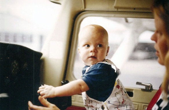
As I grew, his love for aviation and flying remained strong. I spent a lot of time in a cockpit as a child:

dadairplane1yearold

I always thought it was cool to be in a plane and see all of the dials and controls in front of me. Perhaps it was the view out the window of one of my father’s planes that got me interested into weather. My mother can’t remember a time where I haven’t loved weather, and I don’t think my father could either.

We would travel as a family in airplanes. Road trips were only for trips to Indiana to see family or nearby to Rocky Fork Lake.

My father was a proud Purdue University graduate. After living in Long Island very early in his life, his parents moved to northwestern Indiana. His love for aviation grew there; after getting his license, he went to Purdue and focused on aerospace and aviation. He wanted to make flying his career. Years later, when he had a son, it was clear he would fly him places and Purdue would be a place his son respected. Even at Acadia National Park, a picture of Neil Armstrong (the first man on the moon and a Purdue graduate) holding a Purdue flag covered my father’s shirt and mine:

acadianatlparkmaine1980s

Unsurprisingly, my father was a USAF ROTC Cadet. The Army or Navy did not have the draw that the Air Force did…for obvious reasons.

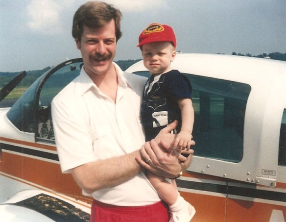
My father came to Cincinnati in 1979. He flew Challengers, Lear Jets, and Hawkers for Cincinnati-based Federated Department Stores and Chemed. He was based out of Lunken Airport for his job but also as a private pilot. He owned numerous airplanes, and he loved to take his wife and son to places. He was a flying instructor, and even gave me two lessons was I was 11 years old.

Of course, some of those trips were related to aviation, such as Kitty Hawk, North Carolina:

kittyhawk1andhalfyearsold

Other trips were to Michigan, Minnesota, Maine, or other scenic spots. With his help, I was fortunate enough to visit over 40 states by age 11.

Because he loved to fly, he was away from home a lot. My mother was a teacher, and she was often there to pick me up from school or get me to practice as I grew older. Despite being under the care of my mother most of my childhood, my father seemed to make it a priority to help me and bond with me when he was around. For the first ten years of my life, I seemed to bond with him more than my mother.

My father was a determined man. As a pilot, he had no choice but to get the plane on the ground every time; that way of thinking translated into other aspects of his life, such as putting a basketball pole 10 feet under ground at my childhood home when I was 9. It took all day, but that pole was getting in the ground:

basketball1994

Some of my memories with him as a child have faded with time, but many have lasted to this day thanks to photos.

Unfortunately, my relationship with my father ended suddenly on September 17,  1996. He was flying in east-central Indiana when the plane he was flying had a mechanical malfunction and crashed.

I remember the phone call as an 11-year-old. I answered the phone, and a man said “Is your mother there?” I passed the phone to my mother, and went back to playing with Legos. Several minutes later, I remember looking up at my mother crying and still on the phone. She got off of the phone to deliver the news, and in a matter of hours, there were dozens of people at the house.

There were a lot of people at my father’s funeral. He was well liked, and I remember how many people had good things to say about him.

19 years later, I still think of him and how life would be different with him here. My mother and I both agree that our lives now would be similar in many ways to what would have happened if he was still here, but we still wonder what specifically would be different.

I learned a lot about the grieving process in the years following my father’s death; most importantly, I learned that the process is different for everyone. Friends grieving from murder or a prolonged, drawn-out death have reached out to me in the last 19 years, and I’ve learned that being there long term and just being a shoulder to cry on or a person to listen is the right way to handle those situations. Being exposed to the grieving process at an early age made me realize how unique our experiences in life are.

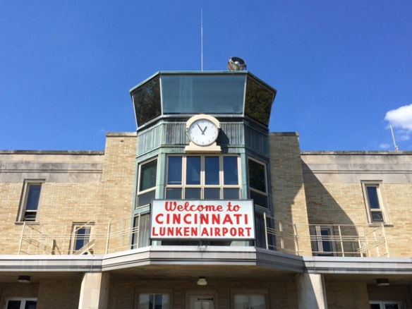
On a daily basis, I think of my father when I check weather conditions. One of the prerequisites to getting clearance to takeoff is knowing the weather conditions at the airport for which you are departing. I am reminded of my father writing down weather conditions on a piece of paper in the cockpit and talking to the control tower every time I check the latest weather observation at Lunken Airport. With aviation being so closely linked to weather, it makes sense that I am a meteorologist today because of what my father taught me and/or exposed me to.

On Wednesday, I was at Lunken Airport for a meeting, I took a photo of the terminal not just because of it’s scenic qualities, but because it reminds me of my father:

lunken

Nearly 20 years after his death, I still remember my father being a “by the book” man. His friends – many of whom I still talk to and know very well to this day – remember him as Dale “know when to have fun, but default to sticking to the rules” Dimmich. He did not cut corners, and he kept the eye on the goal. Safety was his top priority, but taking care of others – including his passengers – was a close second. While my dad was known for these things, those around me can make a strong case that those qualities have been passed on to me.

There were moments where my father was a fighter and stuck up for what was right. There were times where he contemplated issues and got frustrated. He disagreed with people. There were some that got in his way or clawed at him. I saw he was human; even in the limited about of time I spent with him, I learned that getting it all right was not always easy and was sometimes unattainable.

Most importantly, my father taught me about a dream. He wanted to fly, and he became a pilot; similarly, I loved weather, and I became a meteorologist. His death, however, taught me a lot about how distancing yourself from the dream (even if occasionally) can be a good thing. Had my father not being flying in that plane September 17, 1996, my father would likely be still be here. I have no way of knowing what would have happened had he not been flying that day, but I’ve thought a lot about that flight. Do I celebrate him dying doing what he loved, or do I wish he had taken fewer flights to decrease his odds of something going wrong? Either way, I know there are hazards in any job, but I’ve often pushed myself back from the desk to enjoy life elsewhere. Time away from the hazards is not only good for the soul, but it may tip the scale just enough to make life longer.

The metaphor of flying – from takeoff to taxi and from arrival to departure – is a good metaphor of life. My father and I had 11 years together; that’s not a lot of time, especially when you don’t remember half of those years. What my father did do, however, is plant a seed of success in me. He never saw the plant grow to its peak, but he gave it the support to live.

Perspective On 90°+ Heat In September 2015

Today marks the 7th straight day in Cincinnati where the temperature hit or went above 90°. It is not unusual for the temperature to reach 90° during September in Cincinnati, but a week-long stretch of 90°+ heat is uncommon.

Including today, the high temperature in Cincinnati has hit 90° 7 times this month (September 2nd through September 8th). This is the most number of 90°+ days during September in the Queen City since 2010:

sep8-blog-90degreeseptdays

On average, the warmest high temperature of September in Cincinnati is 90°. However, Cincinnati has only hit 90° 51 out of the last 145 years (about 35%). In the last 9 years, the Queen City has failed to hit 90° during September twice:

sep8-blog-warmestsepttemp

Our recent stretch of 90°+ days during September is not a record. In fact, we had 7 consecutive days of 90°+ during September 2007. 10 of the 11 90°+ days in 1897 came in a row:

sep8-blog-90streaks

During the warmest September on record (with an average temperature of 76.37°, about 9.5° above the 1981-2010 average), Cincinnati hit 90° 7 times. While the stretch of 90s in early September brought the average up, high temperatures consistently in the 80s and low temperatures in the upper 60s and lower 70s made September 1881 the warmest.

Through the 8th, September 2015 is off to the 19th warmest start on record. The week ahead looks much cooler with highs in the 80s and 70s.