Remembering The Coldest Morning In Cincinnati 37 Years Ago

In Cincinnati, the month by which all cold or snowy months are measured against is January 1977. Those who have lived in Cincinnati for decades – regardless of when they were born in the 20th century – will tell you the winters of 1977 and 1978 were the coldest and snowiest. The average high temperature that month was 22°; the average low temperature was 2°. In January 1977, the low temperature dropped below 0° 16 days, and the high temperature didn’t even get to 0° one of those days. Over 30″ of snow fell that month, and 13 days of that month began with 10″+ of snow on the ground. It was cold.

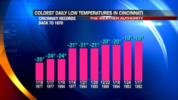
That cold has stood the test of time. 37 years later, 3 of the top 4 coldest early morning low temperatures in Cincinnati were set in January 1977:

jan17-coldest

In the mid 80s and 90s, sharp cold shots and a deep snowpack over the Ohio Valley allowed the temperature to dip to -20° or colder, but those cold blasts were not as prolonged as the cold of January 1977.

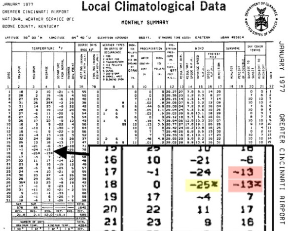
Two of the coldest daily low temperatures on record in Cincinnati were set on consecutive nights. The all-time coldest low temperature for Cincinnati was set on January 17, 1977 (-24°); the following night – January 18, 1977 – the temperature dropped to -25° at the Cincinnati/Northern Kentucky International Airport, which was the new all-time coldest low temperature recorded. Prior to these days, the all-time record low for Cincinnati was -19°, set on January 24, 1963.

The official climatological summary from the National Weather Service shows the all-time record low from January 18th (yellow) and all-time record lowest average temperatures from January 17th and 18th (red) highlighted with an asterisk:

record

Using the average temperature as a measure, January 16th, 17th, and 18th of 1977 is the coldest 3-day stretch on record in Cincinnati.

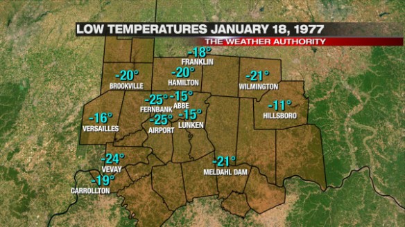
-25° still stands as the all-time record low temperature for the Queen City to this date. Several spots in the Tri-State were just as cold as the International Airport that mid-January morning, but others were not as cold:

jan17-dec1877lows

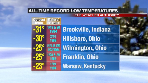
The all-time record low temperature was also set at Fernbank (in western Hamilton County) that morning. Other all-time records in the Tri-State, however, were not set that morning. Here is a small sampling of when all-time record low temperatures were set at several Tri-State locations:

jan17-alltimelows

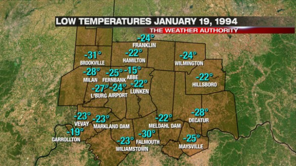
Several all-time low temperature records were set in January 1994, especially on the 19th. The all-time low temperature in Cincinnati was almost matched that day:

jan17-jan1994lows

5-10″ of snow covered the Tri-State on January 19, 1994. Maysville’s all-time record low temperature was set that morning, but January 17th and 18th, 1977 weather records from Maysville are missing…when it may have gotten colder than in 1994.

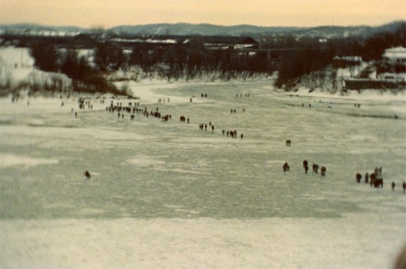
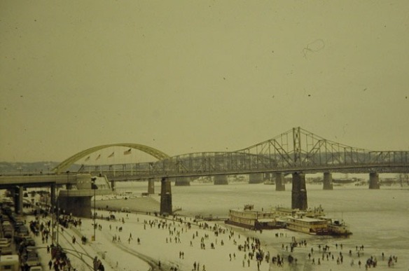
While the numbers tell a story, the photos from January 1977 tell more. Many did what may never be possible again in our lifetimes; they walked across the frozen Ohio River.
jan17-crossing
Frozen Ohio River in January 1977; photo courtesy of Edith Suttle

National Weather Service records show navigation up and down the Ohio River past Cincinnati was suspended from January 25 to February 2, 1977. The photo above shows travel across the river by foot was easier than down the river by boat.
jan17-cathy
Frozen Ohio River in January 1977; photo courtesy of Cathy Lang

The several party boats were stuck along the shore for days. The Showboat Majestic was surrounded by ice.

Not everyone remembers tornadoes, floods, or hail storms; those weather events often affect a select group of people and don’t always leave a large footprint. Perhaps more than any other Tri-State weather-related event, those who lived through the snowiest, coldest January on record or walked over the Ohio River remember it.

The Truth About Next Week’s Cold

While models have wobbled more than usual with the handling of weather systems recently, the latest computer model runs all suggest a large piece of arctic air will drop into the Ohio Valley next week. The specifics about the timing and strength of the cold plunge are nowhere close to being finalized, but a signal of very to extremely cold temperatures should be taken seriously.

There is already a lot of hype about next week’s cold blast on social media. Some models are producing very cold temperatures for the Tri-State next week, while others are suggesting we’ll come close to setting all-time record low temperatures. These same models may change their tune later this week and over the weekend, but for now, they all agree that cold (in some form) is coming soon.

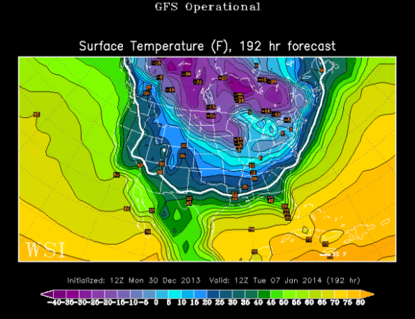
For the sake of simplicity, I’ll focus on next Tuesday morning (January 7th). This morning’s GFS model pushes temperatures to around 0° in Cincinnati that morning:

dec30-gfsop

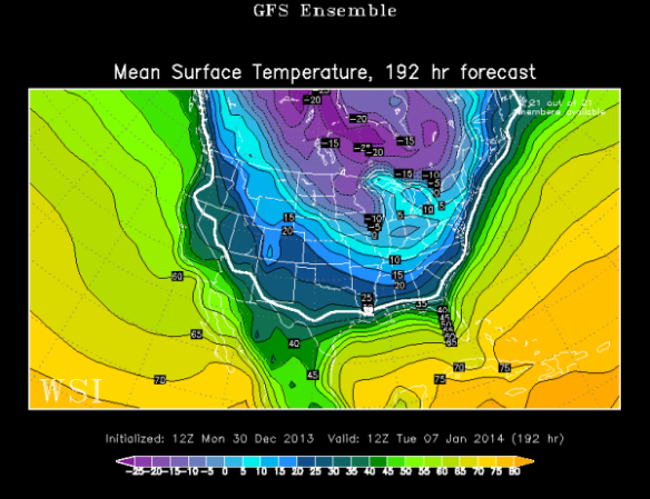
The GFS model ensemble members averaged together suggests we’ll drop between 5 and 10° above zero:

dec30-gfsensemble

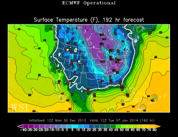
This morning’s ECMWF model says the Tri-State will drop between -10° and -25° below zero Tuesday morning:

dec30-ecoper

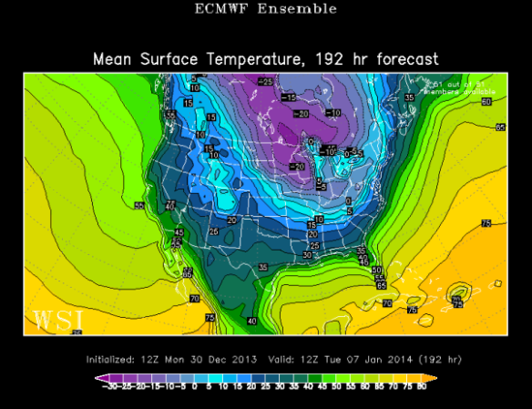
Meanwhille, the ECMWF model ensembles averaged together drops Cincinnati between 0° and -5°:

dec30-ecensemble

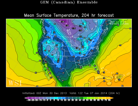
The Canadian model ensembles averaged together – which tends to do well with extreme cold – drops the temperature to around 10° in Cincinnati early next Tuesday morning:

dec30-cmcensemble

Clearly, there is a large spread on overnight lows from one model to the next. Long range forecasting can be very tricky, especially when dealing with the timing of disturbances more than a week out.

Long range forecasting is especially hard this time of the year because:

– The lack or depth of a snowpack can have a large influence on temperatures
– Models tend to overdevelop areas of low pressure in the winter, and – thus the amount of cold air behind departing behind them
– Cloud decks are also tough to forecast more than one week out, especially stratus decks and low-level inversions/stable layers of air aloft

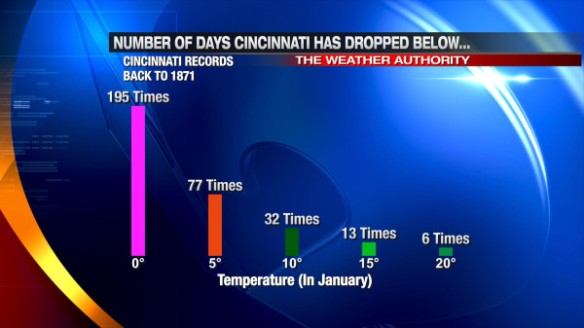
For these reasons and others, forecasting temperatures for next week now is difficult at best. While models may not agree with each other, they are sending a signal of brutal cold. Here’s a list of how many times Cincinnati has dropped below certain temperatures in January since 1871:

dec30-coldtimes

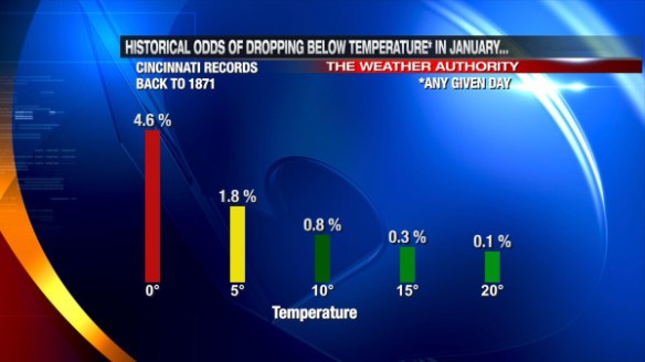
What are the historical odds that the low temperature on any given January day in Cincinnati will drop below these same temperatures?

dec30-historicalodds

On average, Cincinnati drops below 0° two days each January. There have been many years where we didn’t hit 0°, but there have also been years where we hit or dropped below 0° frequently (16 days in January 1977).

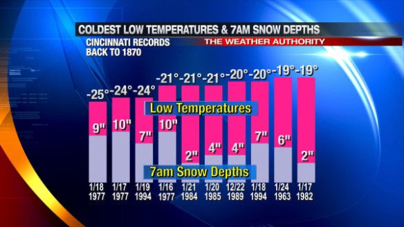
A lot is needed to get a temperature well below zero in Cincinnati. Notice that all of the top 10 coldest mornings on record in Cincinnati had at least two inches of snow on the ground:

dec30-coldestlows

The presence and amount of snow on the ground in Cincinnati has a big impact on how cold we get at night. The presence and amount of cloud cover at night has a impact on how cold the Tri-State gets. The amount of snow to the north and west of Cincinnati (even as far back as the Plains and Dakotas) can have a big impact on how low temperatures go. Just as drought begets drought and wet begets wet, cold and snow begets cold and snow. A dense snowpack from the Ohio Valley to the Plains is often a major contributor to record cold, as arctic air from Canada “holds together” better when it travels south.

Simply put, we are getting signals from recent computer model runs about a significant surge of arctic air next week. Some models suggest we will see near-record cold, but this is highly dependent on the extent of cloud cover and snow cover in the Ohio Valley in the coming days. Stay tuned for what could be one of the biggest – if not the biggest – polar plunges we’ve had the Tri-State in the last couple of years!

Perspective On How Rare Saturday’s Weather Was

Did Saturday’s weather seem unusual to you? It was. In fact, it was very unusual by several different measures. Heavy rain is not common in December, and severe weather isn’t either. We had plenty of both this weekend, fueled by an abundance of warmth and low-level moisture.

How does one measure the weirdness of weather? The easiest way to do this is by variable.

It was hard to ignore the rain this weekend, especially with Friday, Saturday, and Sunday being some of the biggest travel and shopping days of the year.

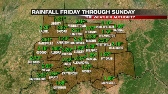
Rainfall totals varied from one community to the next, but most fell into a 1-3″ range; some were just outside the range:

dec22-rainfallmap

While 1-3″ is a significant amount of rain, it doesn’t always lead to problems. For this event, however, it caused widespread flooding thanks to one of the snowiest starts to December on record and temperatures in the 40s, 50s, and 60s before, during, and after rain was falling. Tri-State soils were wet to soaked before rain fell in many communities, and 1-3″ of rain on top of a saturated ground means flooding is imminent.

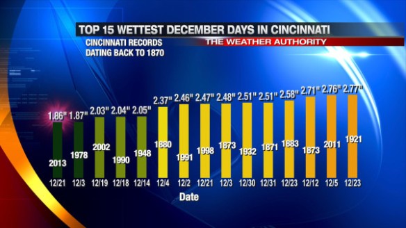
The 2.29″ storm total at the International Airport is about 68% of the average amount of precipitation (rain + melted down snow and ice) Cincinnati gets in the entire month of December. 1.86″ of that total fell between midnight Saturday and midnight Sunday, making Saturday, December 21st the 15th wettest December day on record (since 1870) in the Queen City:

dec22-wettestdecdays

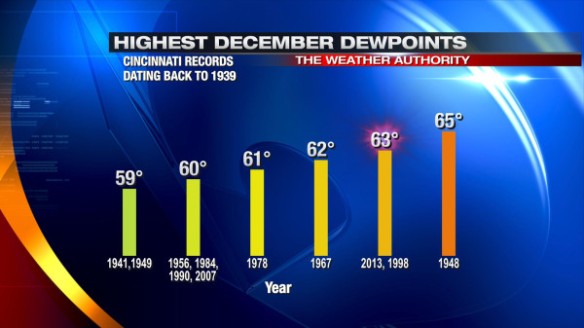
A surplus of low-level moisture and a surge in warmth helped to support the widespread rain and storms that passed through the Tri-State Friday, Saturday, and Sunday. Since reliable hourly weather records began in Cincinnati in 1939, the highest dewpoint recorded in Cincinnati during the month of December was 65°. At the Cincinnati/Northern Kentucky International Airport, the dewpoint hit 63° several times Saturday. A dewpoint of 63° is abnormally high for Cincinnati in December and almost tied the dewpoint “record” set in 1948:

dec22-decdewpoints

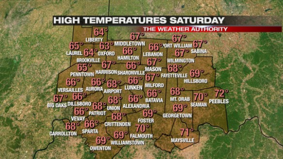
Temperatures were also well above average, helping to create some instability. Our high of 68° was 1° from matching the record high of 69° set in 1967. Here’s a map of Tri-State high temperatures Saturday:

dec22-sathighs

Oddly enough, the weather setup in 1967 (when the record high was set) was similar to Saturday’s. After a dry morning and a rapid warm up from the 40s into the 60s on December 21, 1967, a cold front came through that unloaded 1.06″ of rain; the following day featured a low in the 20s, a high in the 40s, and some flurries in the morning. Similar  to those days in 1967, we’ll start tomorrow around 30°, finish in the upper 30s, and have some flurries and sprinkles in the morning.

In my opinion, what make Saturday unique – or perhaps historic in some ways – was the presence of severe thunderstorms. From the time the National Weather Service Forecast Office in Wilmington first started issuing warnings for the Tri-State in 1995 to the start of this month, only 4 Severe Thunderstorm Warnings had been issued in the Tri-State during the month of December; all of them were issued on December 1, 2006 when a line of storms traversed the Ohio Valley. In this same time period, no Tornado Warnings and only 3 Flash Flood Warnings were issued in the Tri-State.

Last night, 8 Severe Thunderstorm Warnings, 6 Flash Flood Warnings, and a Tornado Warning were issued in the Tri-State. In other words, more Severe Thunderstorm, Tornado, and Flash Flood Warnings were issued in the Tri-State last tonight (both individually and added together) than in all December days from 1995 to 2012 combined.

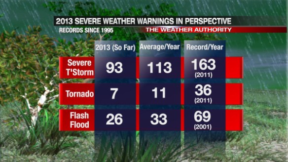
After a very quiet spring and summer severe weather season, here are the latest warning totals for 2013 compared to the yearly records and averages:

dec22-warningtable

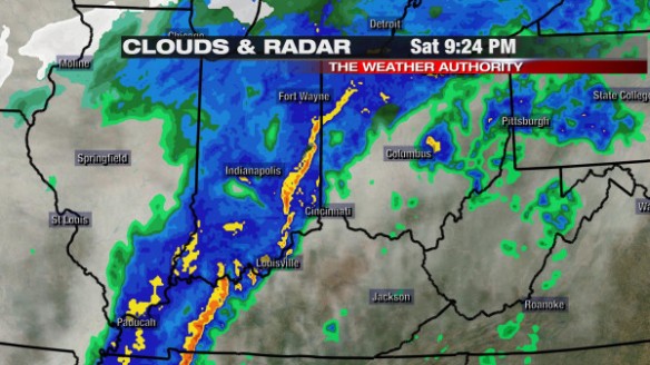
Saturday’s severe weather event and the severe weather event that hit in the Tri-State on Halloween were unique in that damaging straight-line winds were caused more by showers than thunderstorms. Radar data showed a well-defined, narrow line of showers and isolated thunderstorms entering the Tri-State just before 9:30pm last night:

dec22-924pmradar

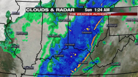
…and east of the Tri-State around 1:30am:

dec22-124amradar

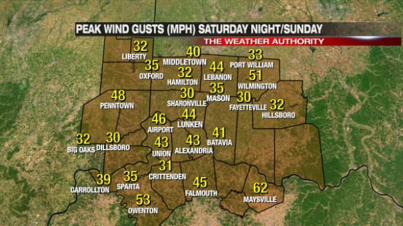
Showers and storms were moving quickly (50+ mph) last night, and their speed and outflow alone was enough to cause damage. In real-time, there was no strong indication that warnings were verifying. The peak wind gust map from last night (including observations from local airport and weather stations) suggests there was little to no damage (60+ mph winds are usually needed to cause damage):

dec22-peakgustmap

When the sun came up and flooding concerns eased some overnight, people found more damage, but most that got damage just had trees or limbs down.

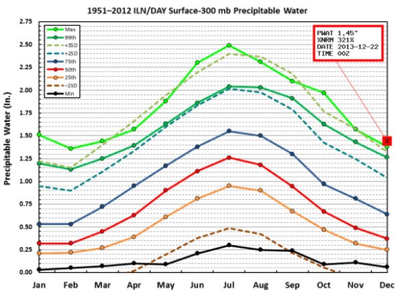
When you get off the beaten path, even more complex weather records were set on Saturday. The precipitable water (atmospheric water content) value measured by Saturday night’s weather balloon launched at the NWS Wilmington around 7pm set a December record (records began in 1948). In the graphic below, the green line represents the monthly records, and the “X” shows last night’s value broke the December record (and was 321% of the December average):

dec22-pwgraph

Regardless of how you measure Saturday’s weather, it’s hard to say it wasn’t unusual, atypical, or just plain weird. As a meteorologist who has worked for several years in the Ohio Valley, you never quite know exactly what you’ll see any given year. After a record number of tornadoes last year, this year has been quieter than usual and with nearly all of our severe weather coming late in the year.

Thankfully, the next few days look quiet with some bouts of flurries and near or below average warmth.

This Weekend’s Weather Setup And Why I Don’t Like It

There are several things about this weekend’s weather setup that are troubling. First, waves of heavy rain are forecast this weekend, this after a couple days of snow melting to saturate the ground. Second, there is a threat for strong and severe storms this weekend in the Ohio Valley; after a quiet spring and summer, this fall and now winter has been very stormy. Severe weather events in the Tri-State during the month of December are very rare.

Several disturbances will affect the Ohio Valley Friday through Sunday; the thinking on the strength and timing of each has not really changed in the last 24 hours.

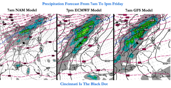
The latest computer forecast model runs all have widespread light to moderate rain in the Tri-State Friday morning and afternoon:

fridaymodels

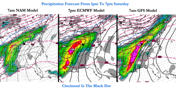
This initial round of rain is not going to cause widespread problems, but it will help to saturate the ground. Models have widespread moderate to heavy rain moving in Saturday afternoon and evening:

saturdaymodels

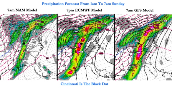
Moderate to heavy rain continues into early Sunday with the center of low pressure to the northwest of Cincinnati:

sundaymodels

Given the dewpoints in the 50s and 60s, temperatures in the 50s and 60s, the positioning of the jet stream, and modest instability, thunderstorms are forecast from Saturday afternoon through Sunday. In addition to the threat of thunderstorms, there is also support for strong and severe storms in the Tri-State Saturday night and early Sunday. Being south of the warm front and east of the cold front puts us in the “warm sector,” or the warm, moisture-rich airmass that will support storms. Specifically, there is a concern for damaging straight-line winds early Sunday morning.

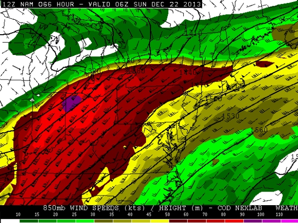
The latest NAM model run has 60-100+ mph winds 5,000 feet above the Ohio Valley at 1am Sunday:

nam850

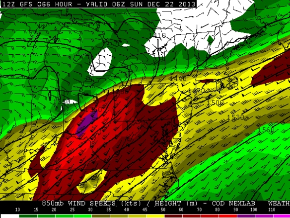
This morning’s GFS model run has the strongest winds positioned differently but just as strong early Sunday morning:

gfs850

This fast moving zone of winds just above the ground is called the low-level jet. It typically strengthens before and during severe weather events, but these speeds are abnormally strong for late December. Mathematically speaking, these wind speeds are 3-5 standard deviations above average for this time of the year. Simply put, these wind speeds are rare to very rare for December. Winds 5,000 feet above the ground are often transferred to the ground – in part or whole – when heavy rain is falling. With moderate to heavy rain forecast as these winds are coming through, there is a concern for severe winds Saturday night and early Sunday morning.

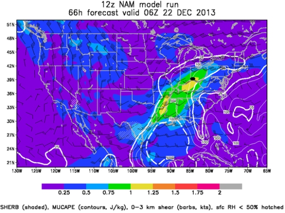
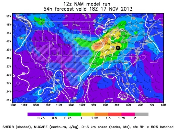
While instability can often have a big influence on the chance for thunderstorms, it isn’t as important this time of the year. If thunderstorms are likely (which they are Saturday night and Sunday), the SHERB parameter or index can be very helpful to a meteorologist in the colder months when looking a threat for severe weather. The SHERB parameter is helpful for getting a handle on a severe weather threat in the colder months because it focuses on temperature changes near the ground, lift in the atmosphere, and wind shear instead of instability (instability tends to be low in the winter even when we get severe weather).

Why is SHERB important? Unlike summer severe weather events which are driven by high instability and less of everything else, cold season events are driven by everything else and not often by instability. SHERB is a special blend of “everything else” that is important when gauging a severe weather threat…which makes it valuable when we don’t have summer-like heat and humidity. When SHERB values are high and the chance for rain and storms is high, severe weather is often a concern.

SHREB values on Saturday night and early Sunday morning are elevated in the Ohio Valley. This morning’s NAM model has SHREB values that are high (yellow) and support a Tri-State severe weather threat (Cincinnati is the black dot):

sherb

SHERB tells us that instability isn’t really necessarily to get rough storms Saturday night and early Sunday. Any instability will only aggravate the atmosphere more than it is already primed.

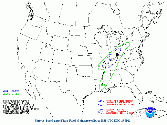
Plus, there is a threat for heavy rain and flooding this weekend. The Weather Prediction Center has already placed the Tri-State in a MODERATE risk for excessive rainfall from 7am Saturday to 7am Sunday:

hpc

A Flood WATCH is likely coming for most if not all of the Tri-State later today. It will likely be in effect most if not all of Saturday and Sunday.

Here is how much rainfall various models are forecasting from 7am Friday to 7am Monday:

NAM         1.72″
ECMWF: 1.94″
GFS          5.40″

The GFS is clearly overdone, but 1-3″+ of rainfall is likely Friday, Saturday, and Sunday.

Be prepared for flooding and storms this weekend!

Severe Threat For The Tri-State Sunday And Sunday Night

Models continue to suggest a significant threat for thunderstorms, strong storms, and severe storms in the Tri-State on Sunday and Sunday night. Since we are still a couple of days out, the exact timing and positioning of this system is still uncertain. There are, however, a lot of similarities in the weather setup for Sunday compared to Halloween night.

Why are we so concerned about the threat for severe weather this weekend? Simply put, the jet stream is strong, it will be warm, it will be rather humid, and there will be a lot of wind shear (changing of the speed or direction of the wind going away from the ground). Notice how I didn’t highlight instability; in the colder months of the year, severe weather events in the Tri-State often happen with little or no instability. The strength of the jet stream, temperatures, lift, and shear are much more important this time of year.

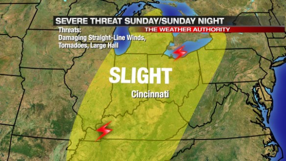
The Storm Prediction Center has placed the entire Tri-State under a SLIGHT risk for severe storms Sunday and Sunday night:

nov15-spcmap

While damaging straight-line winds will be the primary severe weather threat, tornadoes and large hail are still secondary threat with the strongest showers and storms that develop on Sunday and Sunday night. In the forecast model world, there is a consistent signal that that storms will develop to the west and southwest of Cincinnati and move east to northeast with time; this thinking would suggest the main tornado threat will be focused outside of the Tri-State (where storms develop), but – given the amount of wind shear – tornadoes will be possible as showers and storms gradually coalesce into line later in the day and evening.

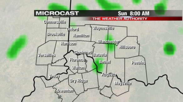
While it is just one model, Microcast suggests the main threat for severe weather will come Sunday evening. Microcast has a relatively low coverage of showers and thunderstorms Sunday morning at 8am:

nov15-mc8amsun

Any sun that we get early Sunday will work against us, increase the amount of instability showers and storms will have to work with Sunday afternoon and evening. In this particular setup, sun and instability is not necessarily needed to get strong and severe storms; any sun we get will only bring up the risk for storms.

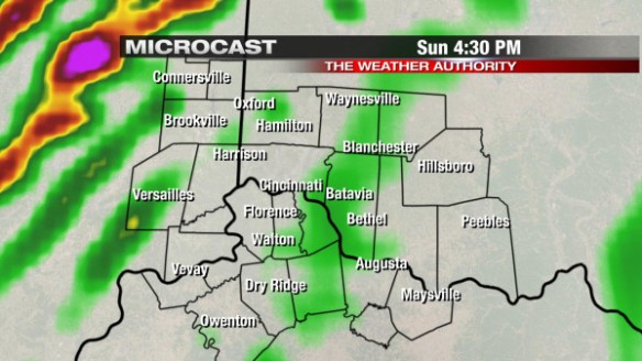
Microcast suggests the coverage and intensity of showers and storms will start ramping up during the afternoon and evening, especially west of Cincinnati. Microcast has most of the storms in the Ohio Valley west of the Tri-State at 4:30pm:

nov15-mc430pm

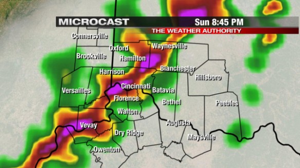
Microcast continues to ramp up the coverage of showers and storms Sunday evening. By early to mid-evening, showers and storms are blowing through the heart of the Ohio Valley:

nov15-mc845pm

By midnight, showers and thunderstorms will be diminishing or ending in the Tri-State, as Microcast shows:

nov15-mc12ammon

Again, Microcast is just one model. Other models are more aggressive with the chance for storms in the afternoon. Know that – for now – the severe weather window begins in the afternoon and continues through the evening.

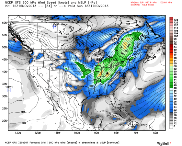
Why are damaging winds the main threat? Because the low-level jet will be very strong Sunday afternoon and evening. The low-level jet is a stream of air about 5,000 above the ground that usually strengthens ahead of strong areas of low pressure. These winds above the ground can easily be pushed down to the surface with heavy rain or in downdrafts (during showers and thunderstorms). Notice the strength of the low-level jet over the Ohio Valley by 1pm Sunday according to the GFS model (Cincinnati is labeled with a black dot):

nov15-gfswind

Winds in green are over 40mph, and winds in yellow are severe (over 58mph). These winds aloft aren’t necessarily what we will see at the ground, but heavy rain and storms will help to bring these winds above the ground down to the Earth’s surface.

There are still significant uncertainties about the positioning of the jet stream on Sunday; this is a problem, since the positioning and strength of the jet stream often tells us where the strongest rising motion will be in the atmosphere (and thus the strongest showers and storms).

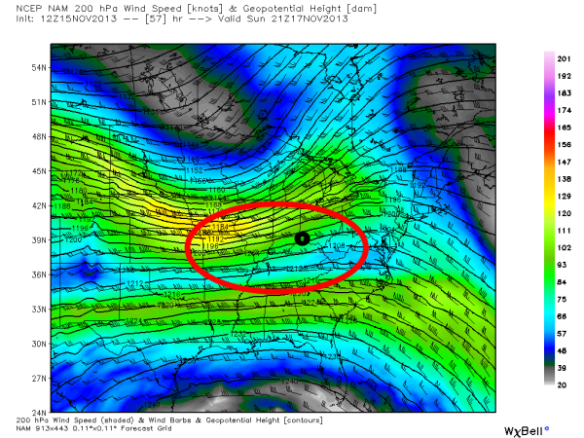
This morning’s NAM model has the strongest divergence (spreading) of air aloft in the red circle by late Sunday afternoon (Cincinnati is in the black circle):

nov15-namjet

Divergence aloft tends to promote stronger updrafts and, thus, stronger showers and storms. Where their are uncertainties about exactly placement of the jet stream(s), we are in the zone of strong lift, and this means we have more than enough upper-level support for severe weather Sunday and Sunday night.

While instability can often have a big influence on the chance for thunderstorms, it isn’t as important this time of the year. If thunderstorms are likely (which they are Sunday), the SHREB parameter or index can be very helpful to a meteorologist in the colder months when looking a threat for severe weather. The SHREB parameter is helpful for getting a handle on a severe weather threat in the colder months because it focuses on temperature changes near the ground, lift in the atmosphere, and wind shear instead of instability (instability tends to be low in the winter even when we get severe weather).

Why is SHERB important? Unlike summer severe weather events which are driven by high instability and less of everything else, cold season events are driven by everything else and not often by instability. SHERB is a special blend of “everything else” that is important when gauging a severe weather threat…which makes it valuable when we don’t have summer-like heat and humidity. When SHERB values are high and the chance for rain and storms is high, severe weather is often a concern.

SHREB values on Sunday and Sunday night are elevated in the Ohio Valley. This morning’s NAM model is very aggressive with Sunday’s severe threat (probably too aggressive), but it has SHREB values that are high (yellow, orange, and red) and support a Tri-State severe weather threat (Cincinnati is the black circle):

nov15-shreb

The ECMWF and GFS models suggest SHREB values will be lower during Sunday’s event, but still high enough to support severe weather.

SHREB tells us that instability isn’t really necessarily to get rough storms Sunday. Instability (sunshine) will only aggravate the atmosphere more than it is already primed.

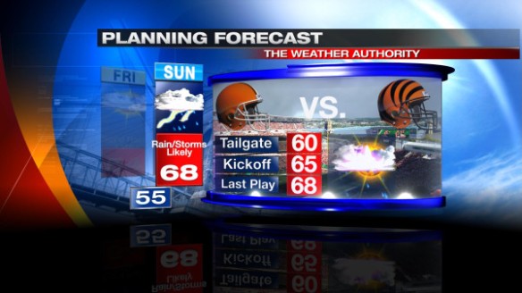
But this discussion is more than just a chance for severe weather on a Sunday; this is a discussion of severe weather on a Sunday where the Bengals are playing and people are outside tailgating and watching the game. It’s much easier to go inside or take cover at home than it is in a parking lot or stadium. I am cautiously optimistic that the Bengals will be actively following the weather Sunday, but you should be prepared for strong and storms Sunday afternoon and evening – especially during and after the game. Ultimately, your safety is up to you. Whether you’re tailgating, going to the game, staying out after the game, or all of the above, you should have a plan to seek shelter if needed. Here is our latest Bengals forecast:

nov15-bengals

The warmth is welcome by most, but don’t write off the wind or chance for storms.

Now is the time to prepare! Don’t be caught off guard in the stands or tailgating on Sunday. While the timing and other specifics of this event are still uncertain, the threat for damaging straight-line winds, tornadoes, and large hail are all on play Sunday and Sunday night.

I’m working this weekend, and I’ll update you as new model runs complete!

Rain To Snow Tonight: First Accumulating Snow Of The Season For Many

As new model runs complete, the overall forecast remains unchanged. At this point, we are nowcasting the event. Satellite, radar, and surface observation trends are becoming much more important as tonight’s rain and snow event nears.

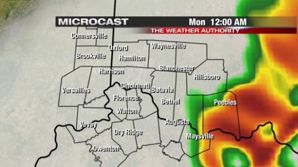
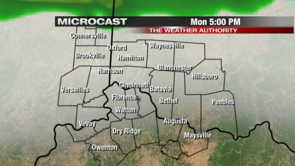
In my blog post yesterday, I discussed how rain would begin around dinner tonight, continue through the evening, transition to snow nearing and especially past midnight, and snow would end nearing sunrise Tuesday. Microcast shows widely scattered showers developing (especially north and northwest of Cincinnati late this afternoon) in the Tri-State:

nov11-mc5pmmon

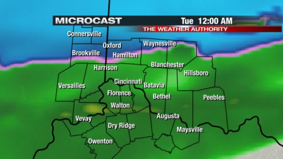
Microcast has only rain in the Tri-State until late evening, when the transition from rain to snow will begin north and northwest of Cincinnati:

nov11-mc12amtue

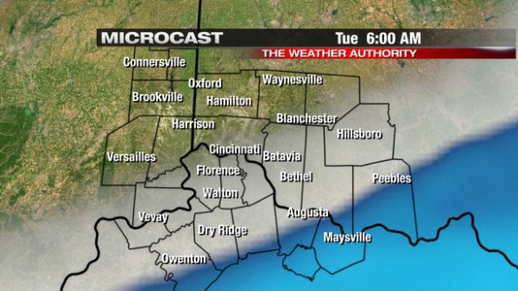
After midnight, all rain will transition to snow, and snow will gradually push south and southeast nearing sunrise Tuesday. By 6am, Microcast shows snow showers south of Cincinnati:

nov11-mc6amtue

If this model – and all of the forecast models that push snow mainly south of Cincinnati by 6am – verifies, the first half of the morning commute tomorrow will be more problematic than the second half. By lunchtime Tuesday, the arctic front (and the snow along it) will be to our south, and temperatures will only be in the mid 30s.

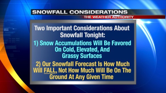
Up to 1″ of snow is forecast in the Tri-State through Tuesday morning. With temperatures around freezing overnight, snow may struggle to stick in spots, and not all of it will be on the ground at once. When we say “snowfall accumulation tonight,” there are some important considerations included in that prediction:

nov11-considerations

The morning commute tomorrow will be tricky. If you’re going to work early tomorrow (especially 3:30 to 5am), be prepared for pockets of visibility-reducing snow and slick roads. After 5am, the coverage and intensity of snow will decrease from northwest to southeast, but slick spots on the roads will likely linger for at least a couple of hours after snow ends. Any snow that is able to accumulate early Tuesday morning will likely melt Tuesday afternoon, especially snow that is exposed to direct sunlight once clouds clear out Tuesday morning.

High temperatures will only be in the mid to upper 30s Wednesday and Thursday. Low temperatures will likely drop into the low to mid 20s early Wednesday and Thursday morning.

Now is the time to prepare for the snow and cold. While a major snow storm is not expected tomorrow, the first snow of the season (and really any snow event in the Tri-State) usually takes some off guard. Allow for extra time getting to work or school tomorrow morning!

Monday Night / Tuesday Morning Event: What It Is And What It Isn’t

There is already a lot of buzz about the cold front moving through the Tri-State tomorrow night and early Tuesday…specifically about the chance for snow that will come with it. This upcoming event is more than just a chance for snow.
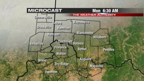
The rest of tonight and early tomorrow will be as quiet as this weekend was. Microcast suggests high- and mid-level clouds will overspread the Tri-State nearing sunrise Monday. Here’s what Microcast shows for 6:30am Monday morning:

nov10-mc630am

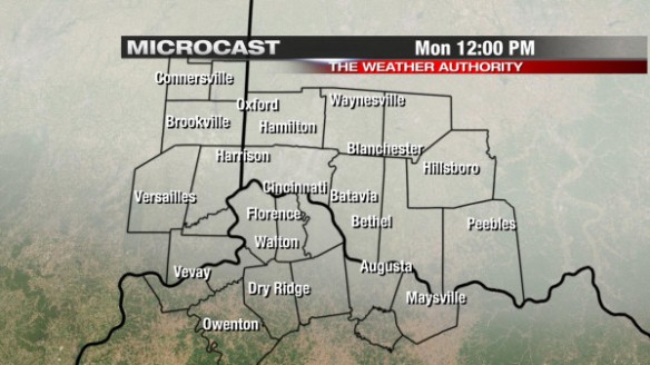
Temperatures will be in the low to mid 30s by early Monday morning. Other than thickening clouds and temperatures rising through the 30s, 40s, 50s, little change in the weather is expected from early tomorrow morning through tomorrow afternoon. Microcast only has thickening clouds at noon Monday…

nov10-mc12pm

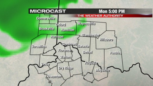
…or at 5pm Monday (but notice showers nearing from the northwest):

nov10-mc5pm

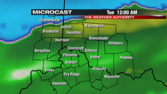
After 5pm, showers will begin overspreading the Tri-State from northwest to southeast. Through 10pm Monday, only rain is expected in the Tri-State; after 10pm, rain will begin transitioning over to snow. Microcast has the rain/snow line (in pink) nearing the Ohio River by midnight Tuesday:
nov10-mc12amtue

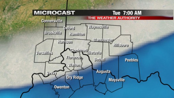
By 7am Tuesday, Microcast – and nearly all other forecast models – have snow showers and flurries pushing south of the Ohio River:

nov10-mc7amtue

Temperatures will drop to around 30° by 7am Tuesday, so snow will struggle to accumulate at times for many. If temperatures were well into the 20s, snow would easily stick, and we would get a lot more than we are forecasting now. Given temperature profiles, the timing of the cold front behind the front, and the temperature of the ground, we are not expecting a lot of snow, but accumulations are still expected for many if not most in the Tri-State.

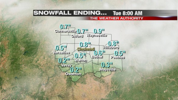
While this is not a specific forecast for a given point, Microcast matches our thinking closely for accumulation on cold, elevated, and grassy surfaces:

nov10-mcsnow

Again, this is a more accurate depiction of snowfall accumulation on grassy, cold, elevated surfaces. Little to no snow is expected on roads, especially if they are treated. Some roads, however, may still be slick, and patches of ice on roads can’t be ruled out (especially in low-lying areas where pavement temperatures may drop near 32°). Overall, 1/5″ to 1″ of snow is expected for our area tonight and early Tuesday morning on cold, elevated, grassy surfaces.

Much of the snow that falls may melt on contact, so few if any areas will have their full storm total on the ground at any given time.

Like all snowfall events, specific amounts are subject to change as new forecast models complete tonight and tomorrow. Stay tuned for possible changes in the forecast.

What This Event Is

This event is likely going to be the first accumulating snow event for many in the Tri-State. Snow accumulations will be light, but the Tuesday morning commute – especially early – could be messy in spots given snow in the area and wet roads. Snow will not be powdery; it will be relatively wet, and much of it will not stick or at least not stick for long. Clouds will decrease quickly Tuesday morning and afternoon, and the sun will help to melt a lot of the snow that falls early Tuesday.

Here’s a timeline of temperatures and precipitation changes for Cincinnati in next 36 hours:

nov10-36hours

High temperatures Tuesday are only forecast to be in the mid to upper 30s, and we’ll be only 1-2° warmer Wednesday afternoon – even with lots of sunshine. Overnight lows will be in the low to mid 20s Wednesday and Thursday night.

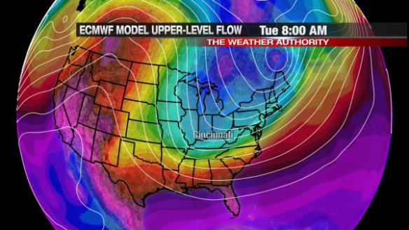
This morning’s ECMWF model shows arctic air (in blue) cutting through the Great Lakes and Ohio Valley by 8am Tuesday:

nov10-ec8amtues

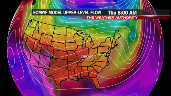
…but has that same arctic air mass retreating back into Canada by late in the work week. Brighter colors (warmer temperatures) from the ECMWF model return nearing this coming weekend:

nov10-ec8amthur

What This Event Isn’t

The cold front that comes into and through the Tri-State Monday night and Tuesday isn’t going to be a major storm. It will not be a major disruption, but it will be an inconvenience. This event isn’t going to close dozens of school districts, but parts of the morning commute Tuesday will be tricky…especially early. The odds of this event producing a “shoveling” amount of snow in your community is unlikely at this point.

Please allow for extra time on your drive to work or school Tuesday!

Cincinnati Winters That Follow Federal Government Shutdowns Tend To Be Snowy And Cold

For the last few days, there has been a lot of focus on the federal government shutdown. National parks and non-essential government employees have felt the effects of this shutdown. Like it or not, many are speculating that the government shutdown could continue for at least a few days or even weeks.

With all of the focus on the consequences of the shutdown, I thought I would try to lighten the mood and see if there was a correlation between a government shutdown and how much cold and snow Cincinnati got in the winter that followed. Ian Livingston of the Washington Post’s Capital Weather Gang looked at a similar correlation (just for the Washington D.C. area), so I tip my hat to him for this idea.

In the modern era (since the mid 70s), Cincinnati winters that follow a federal government shutdown are usually colder, snowier, or both colder and snowier than average. For the sake of this discussion, “winter” is considered to be “meteorological winter,” or December, January, and February only.

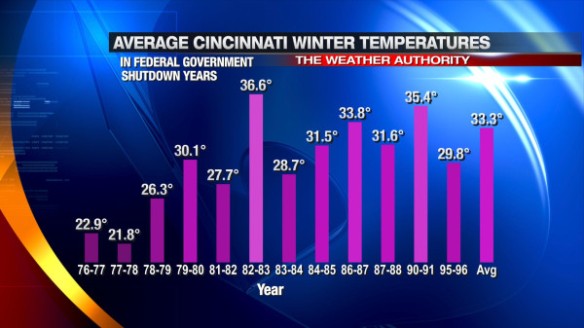
Here are winter snowfall totals in Cincinnati following a federal government shutdown:

oct3-wintertemps

Only 3 out of the 12 winters shown above were warmer than average. Note that the second coldest and coldest winters on record (1976-1977 and 1977-1978, respectively) are listed. The average of all of the “shutdown winters” above is roughly 3.2° below average, although the brutal winters of 1976-1977 and 1977-1978 pull the average down significantly; without these two years included, the “shutdown winters” average is about 1.7° below the seasonal average.

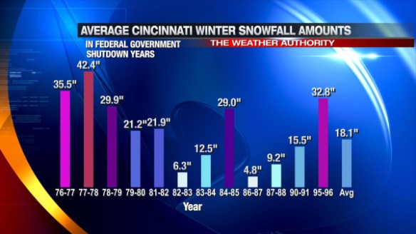
What about snow? Here’s a list of snowfall totals in the winter following a federal government shutdown:

oct3-wintersnow

Only 7 out of the 12 “shutdown winters” above were snowier than average. The average of all of the “shutdown winters” above is roughly 3.7″ above average, although the brutal winters of 1976-1977 (5th snowiest all time) and 1977-1978 (snowiest all time) pull the average up significantly; without these two years included, the “shutdown winters” average is only 0.2″ above the seasonal average.

7 of the 12 “shutdown winters” were both colder and snowier than average.

Of course, this exercise is all for fun. A government shutdown does not mean we will get a certain type of winter. A winter forecast will be developed in the days and weeks to come; look for it later this year.

2013 On Pace To Be One Of The Quietest Severe Weather Years On Record

I’ve blogged about this before because it continues to amaze me with each month that goes by. After a record number of Tri-State tornadoes in 2012, this year has been a very slow one for severe weather. In fact, 2013 will be the quietest year for severe weather in the Tri-State on record by most measures.

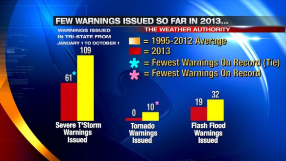
How do Severe Thunderstorm, Tornado, and Flash Flood Warnings so far this year compare to average??

oct2-fewwarnings

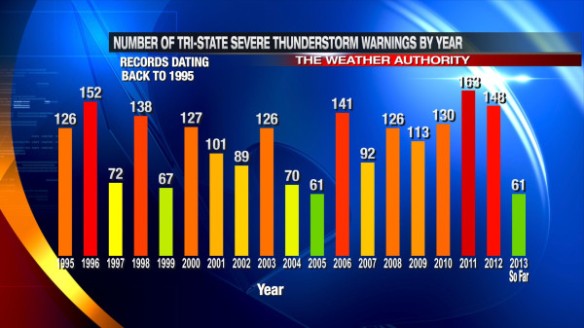
The current Tri-State Severe Thunderstorm Warning count of 61 this year is tied (with 2005) for the fewest Severe Thunderstorm Warnings issued in a year (since the National Weather Service in Wilmington started issuing warnings for the Tri-State in 1995):

oct2-svryear

19 Flash Flood Warnings have been issued in the Tri-State so far this year. While our Flash Flood Warning count is likely to be below average this year, there have been several years since 1995 with fewer Flash Flood Warnings.

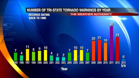
The statistic that continues to amaze me is the fact that no Tornado Warnings have been issued in the Tri-State so far this year. Since 1995, we have never gone an entire year without at least one Tornado Warning being issued in the Tri-State; in fact…since 1995, at least one Tornado Warning had been issued somewhere in the Tri-State prior to July 28th. For perspective, 24 Tornado Warnings were issued in the Tri-State through this date last year.

Here’s a comparison of Tri-State Tornado Warnings issued by year since 1995:

oct2-toryear

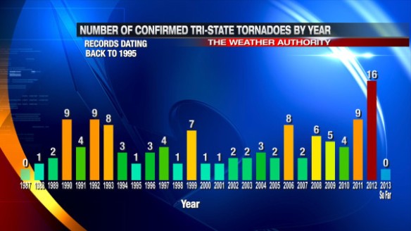
The only thing better to see than 0 Tornado Warnings in a year is 0 confirmed tornadoes in that same area. If we don’t see a confirmed tornado for the rest of the year, 2013 will be the first year since 1987 without one:

oct2-confirmedtornadoes

We need to thank our lucky stars for a boring severe weather season. After going through deadly tornadoes last year (including March 2, 2012 – the deadliest severe weather day in the Tri-State since official tornado records began in 1950), we needed a year to rebuild and regroup.

The last tornado in the Tri-State was on September 8, 2012…389 days ago. Let’s hope we make it another 389 days without a tornado.

What To Expect In October In Cincinnati

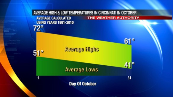
Welcome to October! Today is the first day of the second month of meteorological fall. October, like many months in the Ohio Valley, is a month of change; the most drastic change is in the temperature. While each October is different, the average high temperature drops 11° and the average low temperature drops 10° from October 1 to October 31:

sep30-averagehilo

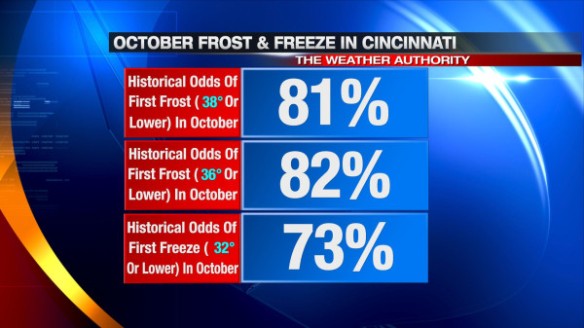
The gradual drop in temperatures – especially low temperatures – signals an increase in the likelihood of frosts and freezes. Historically (1870 to 2012), the majority of first fall frost and first fall freeze events occur in October:

sep30-frostfreeze

In October, extreme cold is very rare in Cincinnati. The temperature has only dropped into the teens 3 times and below 30° 128 times in October since 1870. On the flip side, 90°+ heat is very rare in October. The temperature has hit 90° 6 times in October since 1870. In most years, the last 80°+ day of the year in Cincinnati is in October; the average last 80°+ day of the year is October 8th.

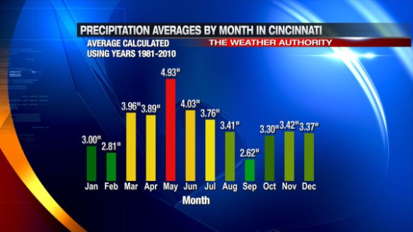
On average, October is the 4th driest month of the year in Cincinnati. September is the typically the driest month of the year, and the average monthly precipitation total increases from September to October and slightly from October to November:

sep30-precp

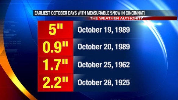
Like it or not, snow becomes a possibility in October. The earliest flurries have fallen in Cincinnati during the fall was on October 12, 1917. The earliest autumn day with measurable snow in Cincinnati was on October 19, 1989. Here are the earliest fall dates where measurable snow fell in the Queen City:

sep30-earliestsnow

What Does October 2013 Look Like?

The latest outlook from the Climate Prediction Center released Monday suggests the Ohio Valley, Great Lakes, and New England will likely be warmer than average in October:

sep30-cpcoutlook

Released Friday, the latest run of the ECMWF Weekly model suggests each week in October will be warmer than average despite a brief blast of Canadian air diving south late in the weekend and early next week. In fact, the latest ECMWF Weekly model suggests the week of October 16th will be abnormally warm over most of the country. The newest ECMWF Weekly model also suggests precipitation amounts will be near or below average in the Tri-State this month.