Warm To Finish The Week, Then Arctic Air Rushes South

For those that like warmer air, temperatures will rise to around 50° Saturday afternoon. If you’re not a fan of cold air, you’re not going to like what’s coming next week. Computer forecast models are coming into consensus regarding an upcoming polar plunge.

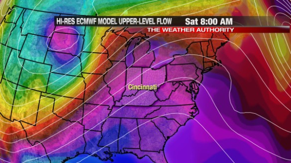
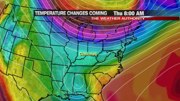
The latest ECMWF model shows arctic air (in purple, maroon, and yellow) north of Cincinnati tomorrow morning:

jan16-8amthur

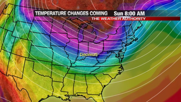
After a brief warmup Saturday, the arctic airmass makes a run to the south. This morning’s ECMWF model has arctic air over much of the Ohio Valley, Great Lakes, and the interior Midwest by 8am Sunday morning:

jan16-8amsunday

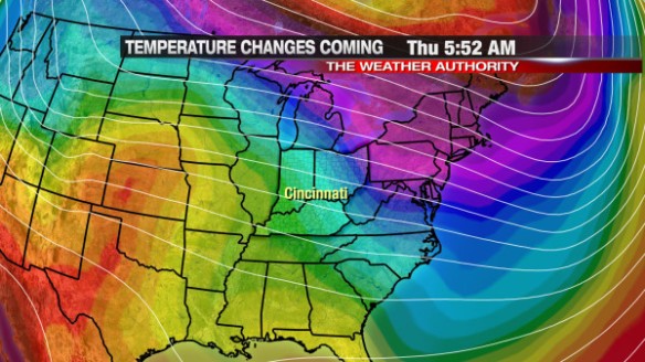
High and low temperatures will likely be well below average through Monday, Tuesday, and Wednesday. By Thursday morning, the latest ECMWF model has a weak ridge of high pressure developing and an increase in warmth over the central United States:

jan16-thuram

For now, Tuesday looks to be the coldest day in the next seven. Early morning low temperatures are forecast to dip briefly into the single digits, and afternoon highs are forecast to be around 20°.

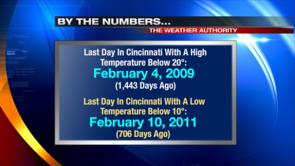
Does this kind of cold sound familiar? It shouldn’t! It’s been a couple of years since we saw a low temperature below 10° or a high temperature below 20° in Cincinnati:

jan16-bythenumbers

Enjoy the warmth Saturday because it won’t last long!

Freezing Rain, Snow, Rain, And Some Sleet Tonight…

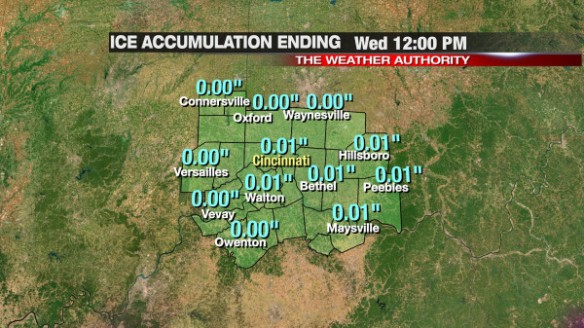
We are halfway through January, and halfway through meteorological winter. Almost 8″ of snow has fallen since December 1st in Cincinnati, but the main concern will be ice tonight. The best chance for seeing ice outside of your home will be from 9pm to 3am; communities north and west of Cincinnati may see little or no ice, while many south and east of downtown will see a glaze of ice by Wednesday morning.

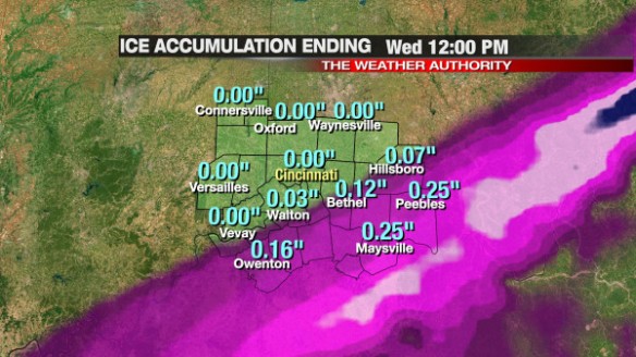
The latest model data disagree on the exact position and amounts of ice, sleet, freezing rain, and snow. PrecisionCast is not excited about our ice accumulation chances tonight:

jan15-adonis

Microcast is more excited (perhaps too excited) about the threat for ice accumulation tonight:

jan15-microcast

I think that Microcast is overdoing ice amounts, and PrecisionCast is under-doing them. If Microcast were to verify, an Ice Storm or Winter Storm Warning would be issued for several counties south and east of Cincinnati.

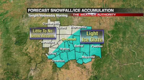
Realistically, most along and south of I-71 will get 0.05″ to 0.15″ of ice accumulation through mid-morning Wednesday. Little to no snow is expected with this event, including northwest of Cincinnati. Here’s our thinking on snow and ice in the Tri-State tonight and early tomorrow morning:

jan15-iceforecast

This forecast may change later tonight, but confidence is high that we will have a rain, snow, freezing rain, and sleet mix tonight and early tomorrow.

Use caution traveling tonight and early tomorrow, as roads may be partially covered with ice. Bridges and overpasses will freeze first!

Long Range Forecast Update

The weekend is coming to an end, and so is a rather warm and soggy pattern. Cincinnati hit 66° before 3am this morning, and temperatures will crash into the 20s overnight in the wake of a strong cold front.

Compared to most of this weekend, the week ahead looks much colder, but still reasonably close to average (average low today: 23°, average high today: 38°).

There are a couple of cold punches to track in the next two weeks.

Arctic Air Coming Later This Week

The latest run of the GFS model (from this morning) is very aggressive arctic air later this week, bringing it into the Great Lakes and southeastern Canada by Thursday morning (as shown in purple, red, and yellow):
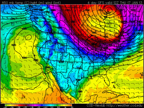
jan13-12zthur850

This morning’s GFS model was not this aggressive with the cold air compared to last night’s or yesterday morning’s run, so I am skeptical of how aggressive the newest run is with arctic air.

With that being said, there is support for this arctic blast from the GFS model runs that are used to create the main GFS model run; meteorologists call these “mini” model runs ensembles. Ensembles are a series of models with the initial conditions changed slightly; if model runs with different initial conditions all point towards a specific solution in time, the odds that a certain type of weather will happen increases. Ensemble forecasting is based off of the idea that computer models often don’t have time (or access to computing power) to ingest every little weather detail for the entire world. Computers often make approximations to save time; ensembles allow us to see how differences in initial conditions make a difference in the forecast. Taking an average or mean of all of the ensembles is a convenient way to see what the ensembles think – overall – in one simple graphic.

This morning’s GFS ensemble mean also has this arctic air over southeast Canada and the Great Lakes Thursday morning, but the core of arctic air (shown in light blue and purple) isn’t quite as strong and isn’t as far south:
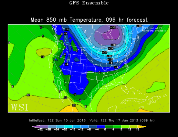
jan13-12zthur850-ensemblegfs

The European model’s ensembles also have this cold punch to our north by Thursday morning, but is even less aggressive with the arctic air into the northern United States:

jan13-12wed850-ensembleec

Clearly, there is some uncertainty on the positioning and strength of the cold air coming later this week. Despite some differences, there is fairly high confidence that this arctic air will put a stop to subtle warming trend forecast Monday through Wednesday.

Arctic Air Coming Next Week

As mentioned above, this morning’s GFS model is very aggressive with pushing arctic air south later this week…and also next week. The GFS suggests this piece of arctic air will be diving south sometime between Monday and Wednesday of next week. Here’s where this morning’s GFS model run puts it (shown in purple, red, and yellow) by Wednesday morning:
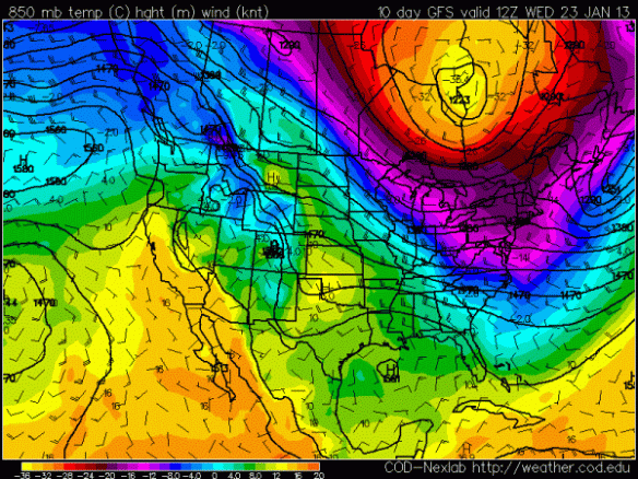
jan13-12wed850

Again, this is a long range forecast and the GFS has just recently gotten aggressive with cold air. For a second opinion, here’s what the GFS ensemble mean suggests for arctic air (shown in light blue and purple) next Wednesday morning:
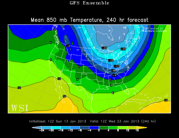
jan13-12wed850-ensemblegfs

The GFS ensemble mean is farther west and not as cold as the GFS. The European ensemble mean is colder than the GFS in Canada but does not have the arctic air as far south:
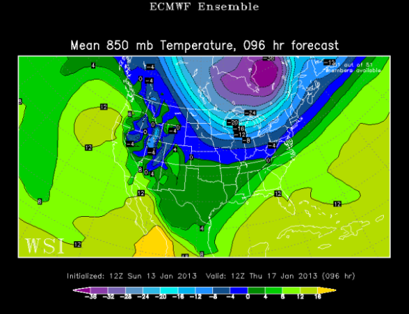
jan13-12wed850-ensembleec

Just like with the forecast later this week, there is a lot to get worked out regarding next week’s potential arctic blast.

For now, I’m thinking we’ll have have highs in the mid to upper 30s Thursday and in the 30s Monday through Wednesday next week. We will likely be on the fringe of both these arctic air masses. This arctic air is here to remind us that winter is not over!

Rain – Heavy At Times – On The Way This Weekend

The potential for heavy rain this weekend has been forecast for days, and – unfortunately – the time to deal with it has come. It will not rain all weekend, but when it rains, it will likely pour.

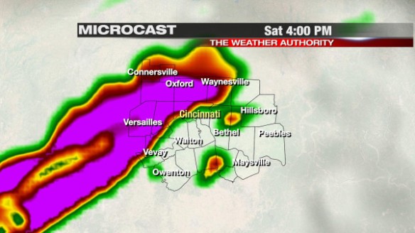
Rain will not fall in the Tri-State until at least 11am. Showers and scattered thunderstorms will likely overspread the Tri-State this afternoon. Microcast has moderate to heavy rain around Cincinnati at 4pm:

jan12-mc4pm

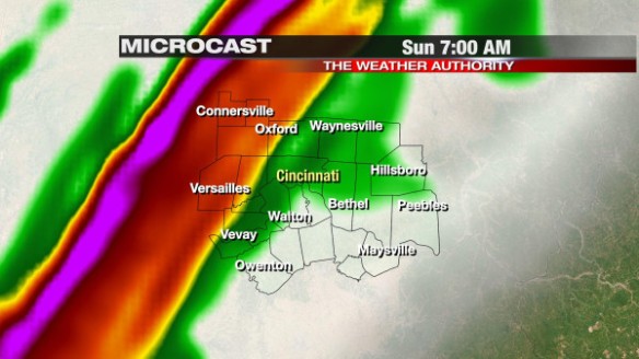
Most higher resolution model data suggests there will be at least a couple of hours tonight with little or no rain in our area, but the threat for heavy rain will rise again late tonight and early tomorrow. Microcast has heavy rain in the Tri-State by 7am Sunday morning:

jan12-mc7am

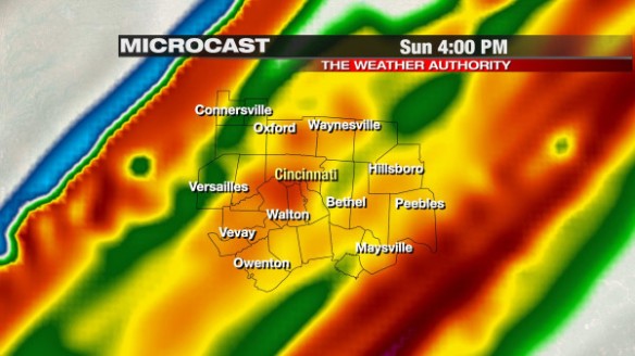
Rain will be heavy at times Sunday morning and afternoon, but thunderstorms are not forecast thanks to falling temperatures, falling dewpoints, and little to no instability. Microcast still has heavy rain in the Ohio Valley late Sunday afternoon:

jan12-mc4pmsunday

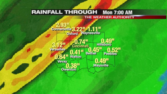
Models disagree on where exactly the heaviest axis of heavy rain will be through Monday morning. PrecisionCast has the 2-3″ swath of rain (in yellow) in the far northwestern part of the Tri-State and central Indiana:

jan12-pctotals

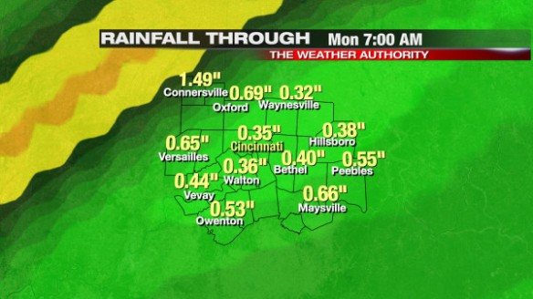
Microcast has the axis of heavy rain through Monday morning farther to the southeast and closer to downtown Cincinnati:

jan12-mctotals

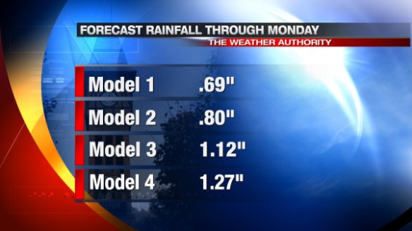
Other computer models give Cincinnati about 0.7″ to 1.3″ of inch through Monday morning:

jan12-totalsthrumonam

If you live in Cincinnati, the odds of getting 1″+ of rain through Monday morning are good. The odds of getting 2-3″ of rain are much higher northwest of Cincinnati.

The ground is soaked thanks to recent rain and almost 8″ of snow (and more northwest of Cincinnati) in the last month and a half. Flooding concerns will be focused northwest of Cincinnati this weekend, and I would not be surprised to see the Flood Watch (now in effect for Fayette and Union County from 7pm tonight through 1pm Sunday) expanded 1-2 counties farther southeast.

What Are The Odds Of Hitting 60°+ In January?

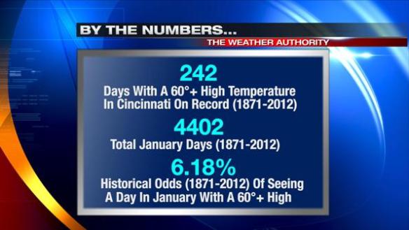
The last time Cincinnati saw a 60°+ high temperature in January was January 31, 2012. The last time before that was all the way back in 2008 (61° on January 8th). We don’t always get to see temperatures in the 60s in January. We average about two 60°+ days each January in Cincinnati, but we once went 5 years straight without hitting 60° in January (1976, 1977, 1978, 1979, and 1980) .

What are the historical odds of getting a 60°+ high temperature any given day in January? Here’s the breakdown:

jan9-60degreejandays

After crunching the numbers, I was a little surprised the odds were this high. In January, getting a high in the 60s usually requires strong southwesterly flow, no snow on the ground, and an abundance of sunshine.

For perspective, the historical odds of hitting 65°+ any given January day is roughly 1.8%. The historical odds of hitting 70°+ any given January day is roughly 0.2%.

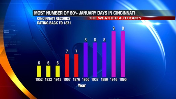
You have to hit 60° at least 6 times in January to make it on the “Most Number Of 60°+ January Days In Cincinnati” list:

jan9-60degreedaysjanuary

The odds of us hitting 60° Friday and Saturday are good, especially with moisture surging up from the south and allowing lows temperature to only fall into the upper 40s to mid 50s.

If you love warm weather, enjoy the spike in warmth late week because high temperatures will be near average in the mid to upper 30s Monday, Tuesday, and Wednesday.

Above Average Warmth And Plenty Of Rain Is On The Way

Our recent warming trend will continue through Saturday. In addition to tracking high temperatures in the 50s and 60s, the week ahead will feature several chances for rain; some of the rain – especially this weekend – may be heavy.

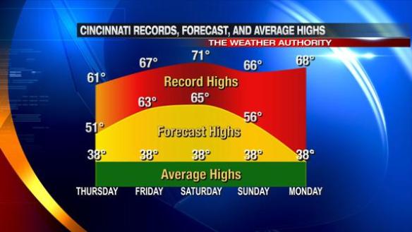
The latest model guidance suggests high temperatures will be near 50° tomorrow and in the low to mid 60s Friday and Saturday. While high temperatures will be 20-25° above average Friday and Saturday, record high temperatures will not be broken or tied.

Here’s how record, forecast, and average highs compare Thursday through Monday:

jan9-recfcastaverage

The record high for both Friday and Saturday were set in 1890. 1890 ended up being the 16th warmest year on in Cincinnati.

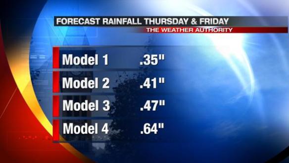
While it will be warm, the next few days will also be rather wet. Models suggest about 1/2″ of rain will fall from tomorrow morning through Friday afternoon:

jan9-thurfrirain

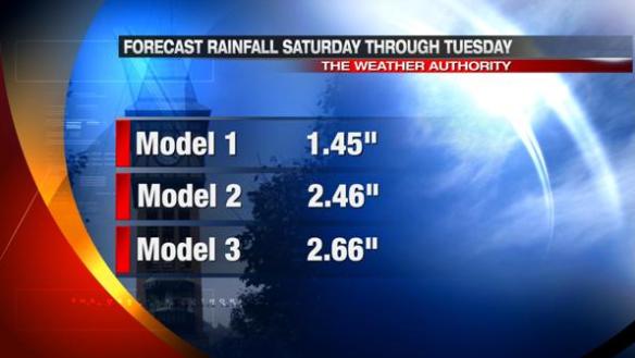
Heavy, widespread rain is coming this weekend and early next week. The heaviest rain will likely be in our area Saturday night through Monday morning. The latest model data suggests 1-3″ of rain will fall from Saturday to Tuesday:

jan9-sattuesrain

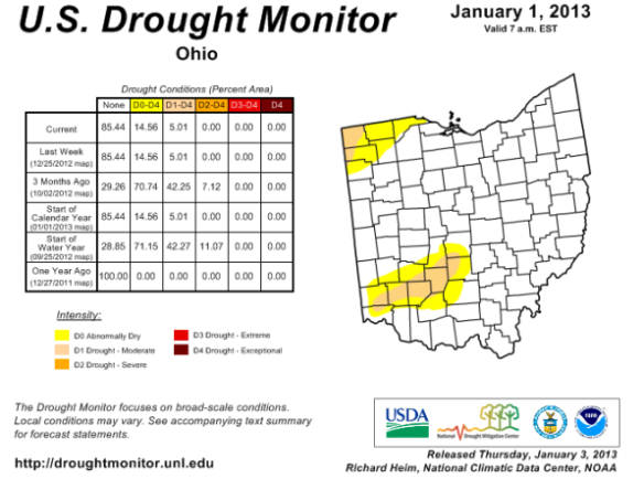
While it hasn’t been discussed in a while, the latest NOAA Drought Monitor (issued January 1) shows areas along and north of I-71 are either abnormally dry or in a moderate drought:

jan9-droughtmonitor

While the rain coming tomorrow, this weekend, and next week may get in the way of your outdoor plans, it will be beneficial.

Warm Up Coming Soon Will Be Short-Lived

A well-advertised warming trend is in progress, but you can’t expect above average temperature runs to last long in January.

Today was our third straight day with an above average high temperature in Cincinnati. We’ll likely be on the warm side of average through the weekend.

High temperatures will approach 60° Friday afternoon, and we’ll briefly jump into the lower 60s Saturday afternoon. The record high temperature in Cincinnati Friday is 67°; the record high Saturday is 71°. Both records were set in 1890. These record high temperatures are unlikely to be tied or broken later this week.

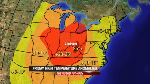
While the records will be safe, high temperatures in the Ohio Valley will likely be 20° to 25° above average Friday:

jan8-frianom

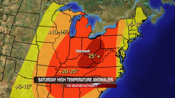
High temperatures in the Ohio Valley will likely be 20° to 25° above average again Saturday:

jan8-satanom

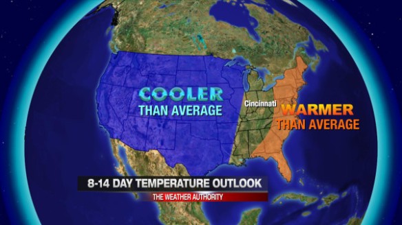
A piece of arctic air is likely to return next week, but there is still some uncertainty on the positioning and strength of this upcoming cold punch. The latest 8-14 temperature outlook from NOAA’s Climate Prediction Center shows below average temperatures are likely next week in and Rockies and Plains:

jan8-814daytemps

We will likely see temperatures near average (in the mid to upper 30s) most of next week.

There are signs from the from the long range model guidance that cold will return later this month and into February. Winter is not over yet!
SPC: 2012 Was A Big Year Tornadoes For In The Tri-State

On Sunday, NOAA’s Storm Prediction Center released updated 2012 tornado statistics. While these are not official statistics just yet, the report from SPC provides insight about the number and strength of tornadoes last year.

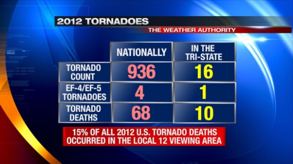
SPC reports there were 936 confirmed tornadoes in 2012. This fell well short of the record of 1,817 confirmed tornado in 2004 but was still enough to get the 25th spot on the list of years with the most tornadoes.

Statistics also reveal that the number of people killed by tornadoes in 2012 nationally was below average. 68 people were killed by tornadoes in 2012; on average, 91 people are killed by tornadoes each year.

While these statistics may lead to you believe 2012 was a quieter-than-average year for tornadoes in the United States overall, it was a record-setting year locally.

When you compare the national statistics against the ones for just the Tri-State, the numbers are rather alarming:

jan7-2012tornadospc

While the 16 confirmed tornadoes in the Tri-State is less than 2% of 936 confirmed tornadoes nationally last year, 16 confirmed tornadoes in the Tri-State is still a yearly record.

Of only 4 confirmed violent (EF-4 and EF-5) tornadoes in the United last year, 1 occurred here in the Tri-State, striking Piner and Crittenden.

The most alarming statistic coming from the SPC’s report is that 10 of the 68 people that died from tornadoes in 2012 unfortunately died here in the Tri-State. In other words, 15% of all tornado-related deaths in country last year occurred too close to home. All of those local deaths can be blamed on the March 2nd tornadoes.

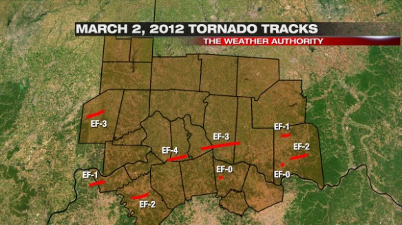
jan7-322012tortracks

The map above shows all of the tornadoes in the Tri-State on March 2, 2012. March 2 was one of the biggest tornado outbreaks the Tri-State has ever seen, but not all tornadoes were not long-track and violent. One of the the devils in the details is the fact that 50% of all tornado-related deaths in the Tri-State on March 2nd occurred in mobile homes.

To read the “United States Tornadoes Of 2012” fact sheet from SPC, click here.

Thoughts On The Long Range Forecast

After several blasts of snow and ice over the last few weeks, a quieter pattern is forecast through mid-week. By late week, southerly flow will be strong, and temperatures will soar into the upper 50s (and perhaps into the lower 60s for some). Beyond this, there are indications that arctic air will plunge into the northern half of the U.S., but this is not certain.

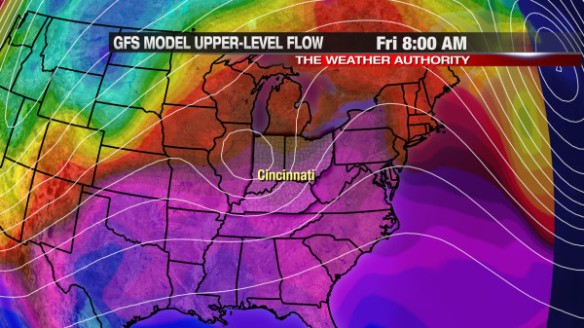
Recent model runs are in good agreement for a late week warm up. While this morning’s GFS model run shows a closed, upper-level low nearby, it also shows abnormally warm temperatures (indicated in red and purple) over the eastern two-thirds of the nation:

jan6-gfs12zfri

The GFS dissolves this upper-level low by Saturday morning, and so does the latest run of the ECMWF. This morning’s ECMWF run also has abnormally warm air along the spine of the Appalachians early Saturday:

jan6-ecmwf12zsat

While it will be warm, it will be wet at times and rather cloudy. For now, the best chance for rain in the week ahead is Thursday and early Friday. Models disagree on the exact timing and strength of the system moving through this weekend.

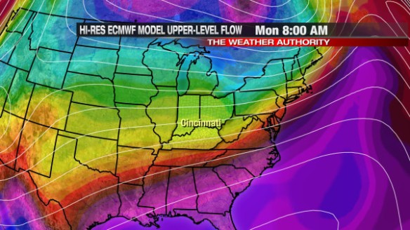
Beyond this weekend, the forecast gets very tricky. The latest ECMWF model has cold air invading from the north (indicated in blue, green, and yellow), but the true arctic air (indicated in dark blue and purple in the top of the graphic) is still in Canada by early Monday morning:

jan6-ecmwf12zmon

The GFS solution is a lot colder next week than what the ECMWF suggests. The GFS has been a more reliable and consistent model as of late, but the GFS has a bias for over-developing areas of low pressure and – in turn – overdoing cold plunges in the wake of them. In addition to the strength, the GFS has also been inconsistent with the timing of this potential arctic outbreak next week. Despite the GFS continuing to show a large blast of arctic air sometime next week, I remain skeptical.

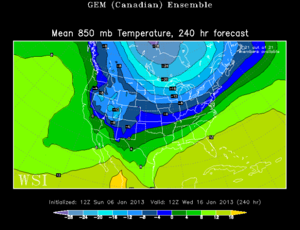
When it comes to arctic outbreaks, the last holdout in the model world is usually the Canadian – specifically the Canadian Ensemble mean. An ensemble is essentially a bunch of models with the initial conditions changed slightly; an average of all of the ensemble members usually gives an accurate indication of what will happen in a broad sense weather-wise. The last Canadian Ensemble mean plot shows arctic air (indicated in blue and light blue) over Canada and some of that arctic air spilling into the Mississippi and Ohio Valley:

jan6-cmc12zwed

If you take this model output at face value, next week looks rather cold around Cincinnati, but not extremely cold. Because the plot above is an “average,” it’s difficult to see localized extremes in temperature; nonetheless, the idea is clear: there is the potential for large cold blast next week, but the specific timing and positioning of this cold air is uncertain. I don’t see support for a large arctic outbreak like many have advertised. My experience tells me large arctic outbreaks are not likely until they are supported by the Canadian Ensemble.

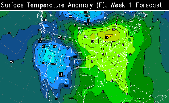
The latest ECMWF Weekly model (that came out Thursday night) shows above average warmth (indicated in bright green) for the Tri-State from Tuesday to next Monday:

jan6-ecmwfweek1

The latest ECMWF Weekly model also keeps us in above average warmth from January 15-23:

jan6-ecmwfweek2

The ECMWF Weekly wants to keep the core of arctic air over the Rockies and southern Canada, working against recent GFS model solutions of a large arctic outbreak next week.

With confidence, I can say next week looks colder than this week. I’m leaning towards a prolonged colder-than-average stretch next week over a major arctic outbreak (with highs consistently in the 20s) like the GFS model suggests.

What Was The Biggest Local Weather Story Of 2012?

When you reflect on all of the weather events in the last year, what do you think was the biggest? Was it the 100°+ heat this summer? Was it the snow and ice late in December? Was it the daily rainfall records set early in the year? Was it the drought that lasted for months?

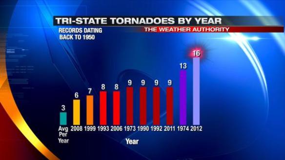
To me, undoubtedly, it was the number of tornadoes in the Tri-State (16 total). 9 of these tornadoes occurred on March 2, 2012, and one was violent (an EF4 tornado); 10 people died in that event alone. On average, 3 tornadoes are confirmed in the Tri-State each year. Here’s how the number tornadoes in 2012 stack up against records dating back to 1950:

jan1-2012tornadoes

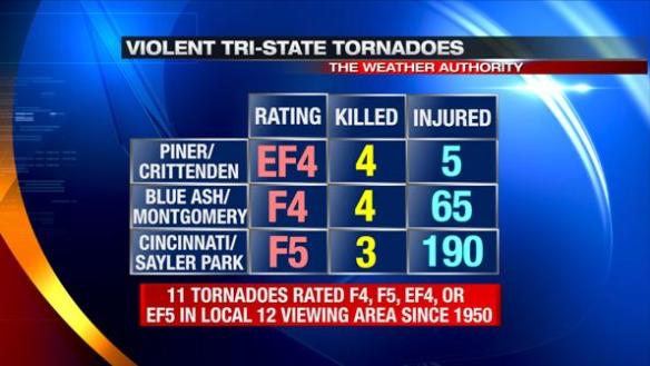
The Piner/Crittenden tornado was originally rated an EF-3 tornado, but was upgraded to a EF-4 tornado 7 days after it hit. Including this tornado, only 11 tornadoes in the Tri-State have been given an F4, F5, EF-4, or EF-5 rating since records began in 1950:

jan1-violenttornadoes

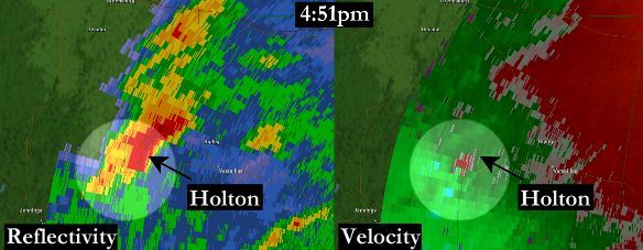
The Terminal Doppler Weather Radar (TDWR) used to track storms around the Cincinnati/Northern Kentucky International Airport captured the tornadic supercells on March 2, 2012. In this scan from 4:51pm, a hook echo (left) and strong rotation (green next to red on right) were apparent with the storm that produced EF-3 tornado damage in Holton, Indiana:

TCVGholtonZandV2jpg

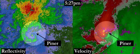
The TDWR also captured strong rotation (on right) and a debris ball (on left) with the tornadic supercell that hit Piner, Kentucky:

pinertdwrZandV-ZandVshadedjpg

A debris ball is a “ball” of higher radar returns caused by larger objects (debris) being lofted by a tornado.

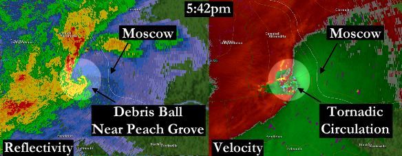
This supercell continued into Campbell County, producing another debris ball and tornado signature near Peach Grove, Kentucky:

peachgrovetcvgZandVwithmoscowjpg

In total, 10 people died in the Tri-State as a result of this event. The first ever Tornado Emergency was issued on March 2nd, 2012; another one was issued shortly after the first one.

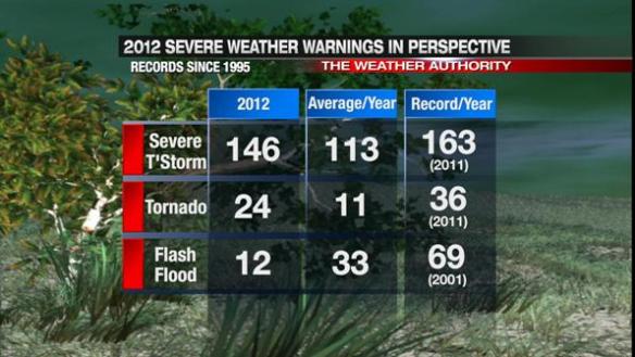
Despite March 2, 2012 being the deadliest severe weather day in the Tri-State since records began in 1950, the number of Tornado Warnings issued in that same area (26) did not break a yearly record (36 set in 2011):

jan1-2012warnings

The number of Severe Thunderstorm and Tornado Warnings in the Tri-State were both above average. Given the drought most of the year, Flash Flood Warnings were rare.

Many in the United States – including the national media – focus on only the Henryville tornado when March 2, 2012 is discussed. While 11 people tragically died from the tornado that tracked north of Louisville that day, March 2, 2012 was more than just this tornado. The people who were injured and killed by tornadoes on March 2nd in southwest Ohio, southeastern Indiana, and northern Kentucky should not be forgotten.