Forecast & Severe Weather Update

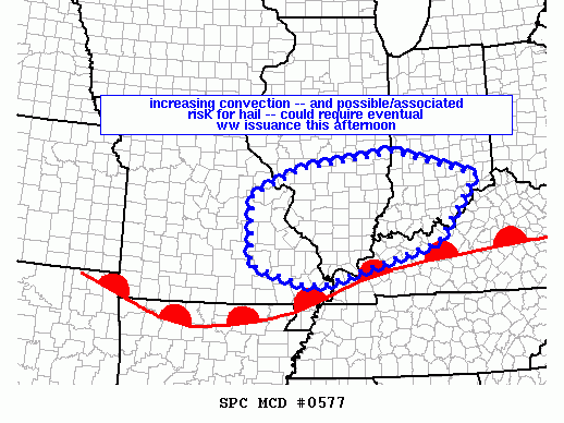
As of 3:15pm, the Storm Prediction Center is considering the issuance of a Tornado or Severe Thunderstorm WATCH for parts of the Ohio Valley including the western Tri-State:

mcd0577

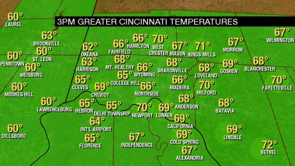
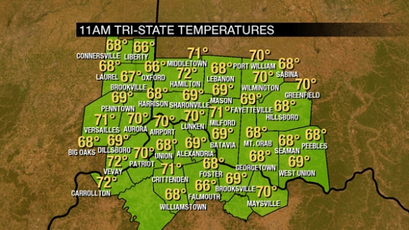
Temperatures are rising through the 60s and 70s as of 3pm, increasing the amount of instability and likelihood for strong and severe storms:

temps

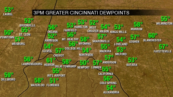
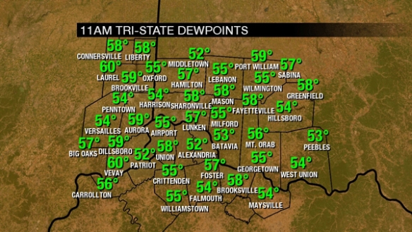
Dewpoints have also been rising this afternoon, and this is an impressive rise since this morning when dewpoints were in the the 40s:

dewpoints

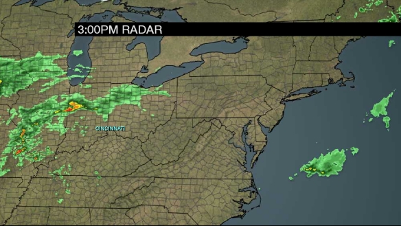
A 3pm radar snapshot shows showers and thunderstorms developing to the west of Cincinnati and Tri-State:

radar

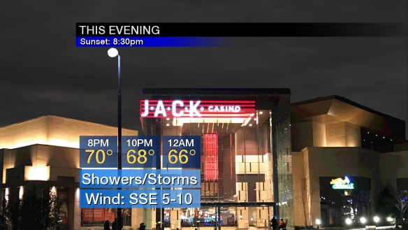
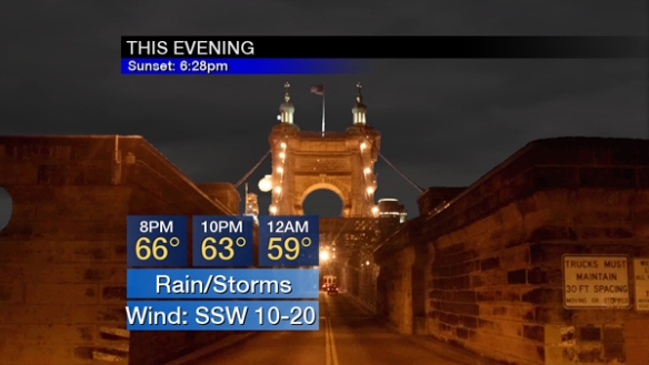
Current thinking is that showers and storms will rapidly develop and increase in coverage late this afternoon and early this evening and continue in waves through the second half of the evening and overnight:

evening

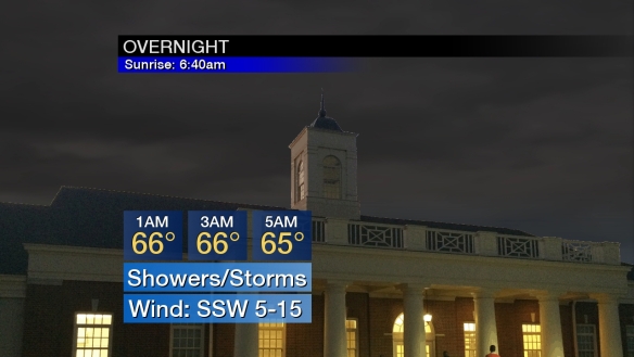
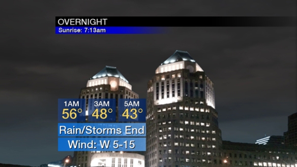
The coverage of showers and storms will gradually drop late in the overnight, but flash flooding is the main concern from late evening through sunrise:

overnight

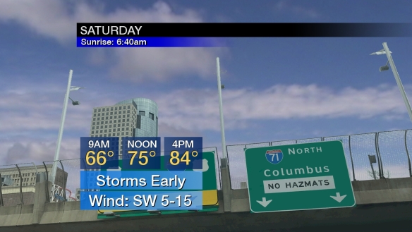
Showers and thunderstorms will be favored early Saturday, then partial clearing and rapid warmup comes during the afternoon:

saturday

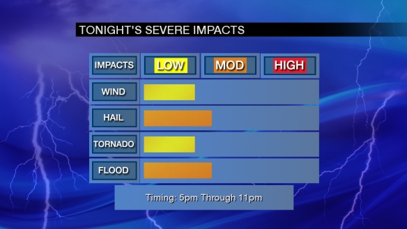
I have increased the threat for tornadoes, flash flooding, and large hail slightly from my last update this morning:

impacts

The tornado threat is focused along and south of the Ohio River through early evening. The other threats are distributed around the entire Tri-State.

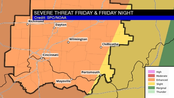
The Storm Prediction Center still has the entire Tri-State in a slight to enhanced risk for severe storms through sunrise Saturday:

impacts

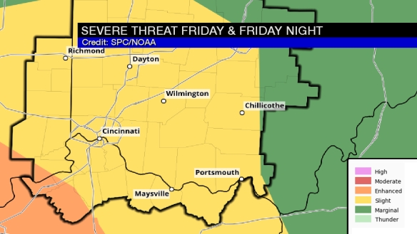
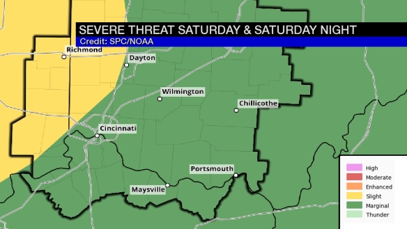
The threat for severe storms Saturday and Saturday night will be focused northwest of Cincinnati:

spc2

This is forecast the threat of strong storms very early Saturday and also late Saturday night/early Sunday.

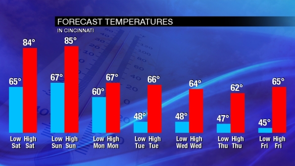
If you’re tired of this warm and stormy pattern, longer-range guidance has us much cooler next week:

temptrend

Let’s Talk About Wednesday’s Severe Threat

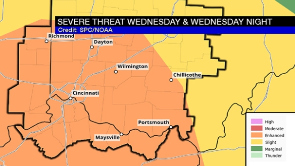
The Storm Prediction Center has placed the entire Tri-State in an ENHANCED risk for severe storms Wednesday and Wednesday night:

apr4-blog-spc

This is a significant threat for strong and severe storms, but – as I will highlight below – it is conditional on how warm and unstable the low-levels of the atmosphere get.

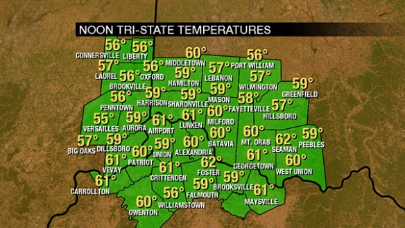
First, let’s address how we get there. We’re around 60° as of noon:

apr4-blog-11amtemps

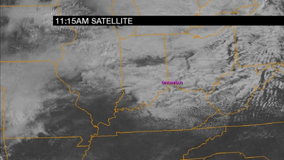
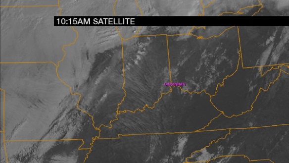
Clouds will win out over sun today, but at least some cracks in the clouds will allow the temperature to rise. Here’s a cloud snapshot as of 11:15am:

apr4-blog-1015amclouds

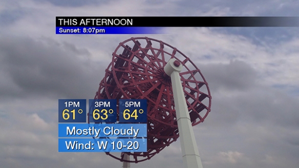
Temperatures will rise into the low and mid 60s this afternoon under a mostly cloudy sky:

apr4-blog-afternoon

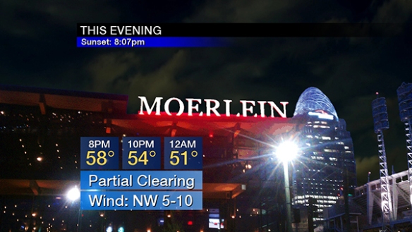
Partial clearing is forecast this evening with temperatures falling through the 60s and 50s:

apr4-blog-evening

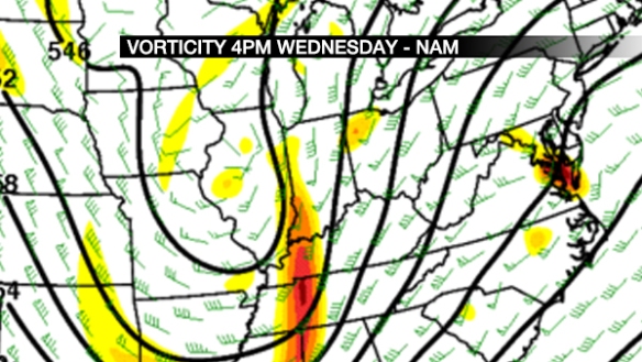
Clouds will increase and thicken Wednesday. From mid-morning through mid-afternoon, scattered showers and stray, non-severe storms will develop. The coverage and intensity of storms will increase between mid afternoon and early evening. The environment these storms will be in is important. For this, we’ll use the NAM model from Tuesday morning, which has a higher resolution than most models and has a decent handle on the overall setup.  It shows an intensifying upper-level disturbance around 18,000 above the ground at 4pm Wednesday:

apr4-blog-vort

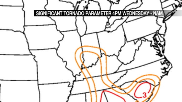
This will provide lift in the atmosphere and help to generate storms. The Significant Tornado Parameter (the higher the number, the more likely tornadoes are if other conditions are supportive) shows the tornado threat focused over Indiana at 4pm Wednesday, but that threat will diminish (but still be more than high enough to watch) and move east from 4pm Wednesday through late evening:

apr4-blog-sigtor

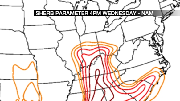
The SHERB parameter (an index of severe thunderstorm in low-instability/high-shear environments; see more in this blog post) shows a significant threat for strong to severe storms in the Ohio Valley late Wednesday afternoon and Wednesday evening. Values in the red usually gather my attention:

apr4-blog-sherb

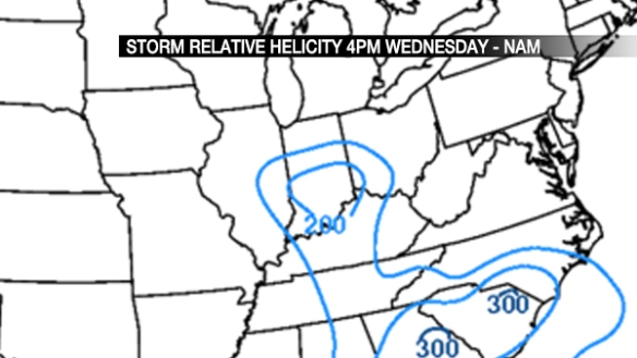
If thunderstorms form Wednesday, how likely are they to rotate? A good indicator of this is storm relative helicity. In simple terms, a tightly-thrown spiral on a football tossed straight up into the sky has good helicity. Here is what the NAM model thinks for helicity at 4pm Wednesday:

apr4-blog-srh

That bubble of 200 (m2/s2) is enough to get my attention and support a tornado threat.

There is, however and as discussed above, uncertainty on how much instability we get. Dewpoints are forecast to rise into the upper 50s Wednesday afternoon, but the instability forecast is messy. Weak instability means a lower severe threat.

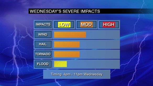
Here’s my overall thinking on Wednesday’s severe weather threat as of Tuesday afternoon:

apr4-blog-impacts

The window for severe storms is 4pm to 11pm Wednesday, but the highest threat centers between 5pm and 8pm Wednesday.

Remember, this is not a final forecast. Conditions and guidance may change in the next 36 hours.

Let’s Talk About Tonight’s and Wednesday’s Severe Weather Threat

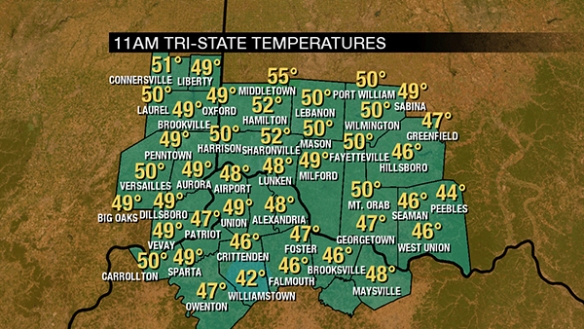
Temperatures have been slow to rise today thanks to soaking rain. As of 11am, temperatures are in the upper 40s and lower 50s:

feb28-blog-11amtemps

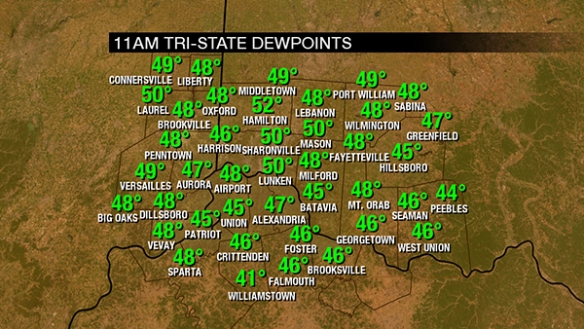
Dewpoints are in the upper 40s and rising. These numbers will rise through the 50s and to near 60° this afternoon and evening:

feb28-blog-11amdewpoint

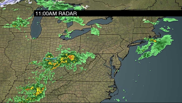
As of 11am, clusters of rain and storms have been marching east through the Tri-State this morning:

feb28-blog-11amradar

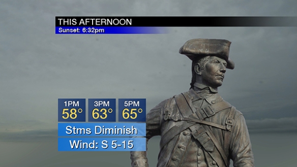
Showers and thunderstorms will decrease in coverage and intensity this afternoon as temperatures rise through the 50s and 60s:

feb28-blog-afternoon

Few if any showers will be floating through the Tri-State late this afternoon and this evening, allowing instability to build and increasing the likelihood for strong and severe storms as a cold front nears from the west:

feb28-blog-evening

Wind speeds will increase this evening as low pressure to the west deepens.

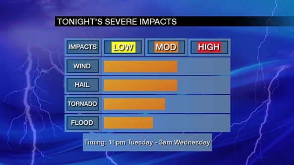
Based on the latest guidance and recent trends, there are two windows of opportunities for severe storms through Wednesday. The first comes between 11pm and 3am tonight. This is the main driver behind the Storm Prediction Center’s enhanced to MODERATE risk for severe storms through sunrise:

feb28-blog-spc1

Between 11pm and 3am, the main severe weather threats are damaging straight-line wind and large hail. Tornadoes are a secondary threat at this time. Storms that come through will likely sweep through as clusters, not a distinct line:

feb28-blog-impacts1

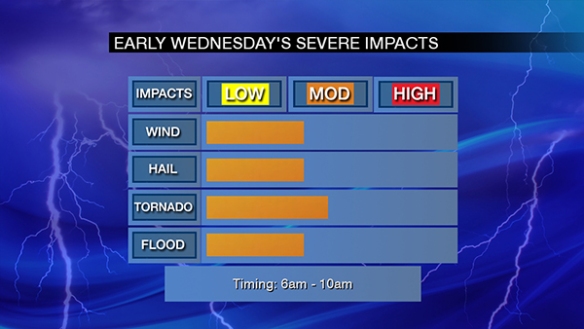
A secondary wave of strong and severe storms will come between 6am and 10am. With this wave, the main severe weather threats are tornadoes and damaging straight-line. Large hail is a secondary threat at this time:

feb28-blog-impacts2

This early morning threat is fueling the Storm Prediction Center’s slight to enhanced risk on Wednesday:

feb28-blog-spc2

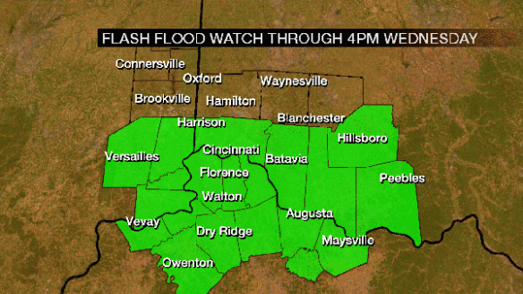
In addition, there is a Flash Flood Watch for most of the Tri-State through 4pm Wednesday:

feb28-blog-watch

1-2″ of rain will fall tonight and early Wednesday.

Be alert. Have a way to get warnings!

Near Record Warmth Fuels Severe Threat Tonight

Temperatures will soar into the mid 70s this afternoon with more sun than clouds. Today’s record high temperature is 72°, set in 1930. The all-time record high temperature in Cincinnati for February is 76°, set on February 10, 1932.

As of 11am, temperatures are already in the upper 60s and lower 70s:

feb24-blog-11amtemps

For February standards, the dewpoint is very high at 55° as of 11am:

feb24-blog-11amdewpoints2

For perspective, the average February dewpoint in Cincinnati is 24°, and the record highest dewpoint in Cincinnati.

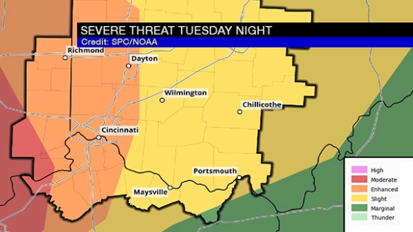
As of 11:30am, the entire Tri-State is in an ENHANCED risk for severe thunderstorms through tonight:

feb24-blog-spc

This threat will be maximized this evening. More sun than clouds will lead to temperatures rising into the 70s as instability grows:

feb24-blog-1015amclouds

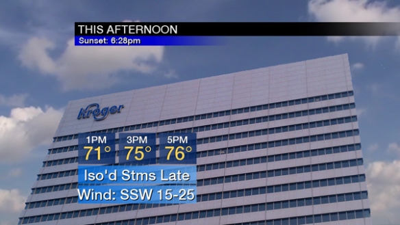
Plan for a mix of sun and clouds this afternoon before isolated showers and storms begin developing between 4pm and 6pm. Wind speeds will increase this afternoon (sustained between 15 and 25mph by 5pm):

feb24-blog-afternoon

Rain and storms will increase in coverage and intensity this evening as a cold front nears:

feb24-blog-evening

Rain and storms will push east of the Tri-State between 12am and 3am. Notice temperatures will fall through the 60s and 50s this evening and then through the 50s, 40s, and into the 30s late tonight:

feb24-blog-overnight

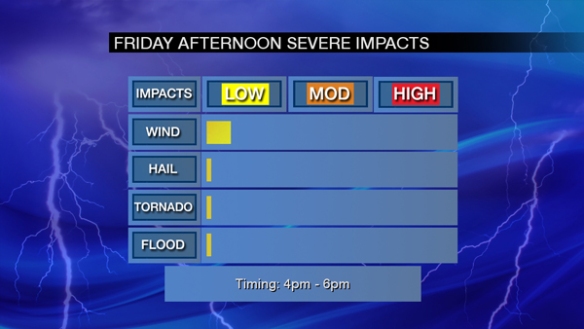
Over the last few days, I’ve been posting a impact graphic for Friday’s severe threat. Now that it’s Friday, I’ll break the threats down by period, starting with late this afternoon:

feb24-blog-impacts1

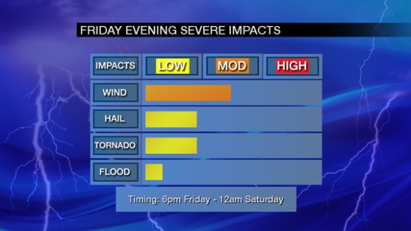
This is a minimal severe weather impact, but this evening’s severe threat will be much higher with damaging straight-line wind being the main concern (and tornado and large hail being secondary threats):

feb24-blog-impacts2

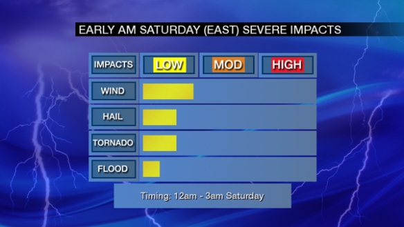
The threat for severe storms will end and be focused east of Cincinnati in the early overnight:

feb24-blog-impacts3

Since 1995 (when the National Weather Service in Wilmington opened), the record for the greatest number of warnings in the Tri-State during a single February is 12 (set in 2002). There are an average of 3 Severe Thunderstorm Warnings issued in the Tri-State each February.

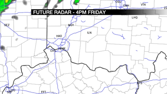
So what might the radar look like? Guidance is still messy, so I encourage you to follow the overall trend in these graphics. Here is what high-resolution guidance suggests the radar might look like at 4pm today:

feb24-blog-4pmradar

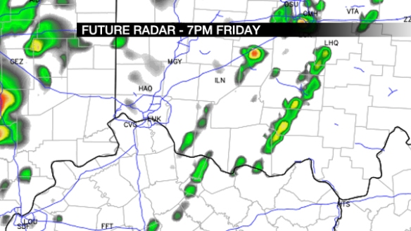
Basically, storms are starting to develop along/north/west of I-71, but the coverage is limited. The main event comes this evening. Let’s fast forward to 7pm:

feb24-blog-7pmradar

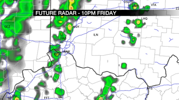
Storms are increasing in intensity and coverage. Other guidance suggests two lines of storms forming near and west of the Tri-State. Let’s go to 10pm:

feb24-blog-10pmradar

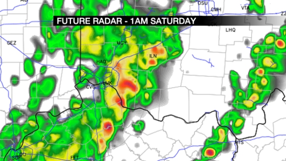
Lines of showers and storms are sweeping into and through the Tri-State late in the evening. Some storms may be strong or severe at this time. Let’s fast forward to 1am Saturday:

feb24-blog-1amsaturday

Rain and storms are moving through southwestern Ohio and northern Kentucky. Strong and severe storms are still a possibility at this time, but the overall threat is diminishing.

Have a way to get watch and warning information today and tonight. Do not think because the sun sets tonight that the threat for severe weather is dropping. 

Friday’s Severe Threat Has Increased

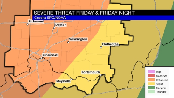
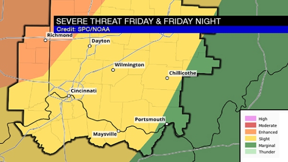
Before sunrise this morning, the Storm Prediction Center pushed much of the Tri-State into an enhanced risk for severe storms Friday:

spc

This is an upgrade to the risk from yesterday when the enhanced risk only came into Fayette, Union, and Franklin County of southeastern Indiana. The risk is lower in the southeastern Tri-State.

A line of rain and storms will likely sweep into and through the Tri-State Friday night with discrete, individual cells (potential troublemakers favoring areas along/west/north of I-71 and along/west of I-75).

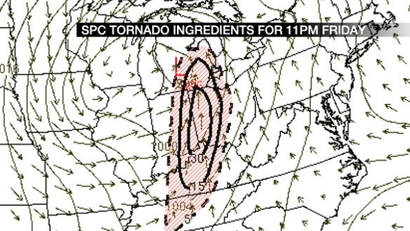
Much of this bump up in the risk is driven by the tornado threat. SPC’s Short Range Ensemble Forecast “Tornado Ingredients” composite (a mush-mash of tornado parameters with varying weights) has highlighted the Tri-State at 11pm Friday:

feb23-blog-spcingr

Note that 11pm Friday is not the specific time severe weather is expected in the Tri-State; there is a window, and this time is near the center of that window.

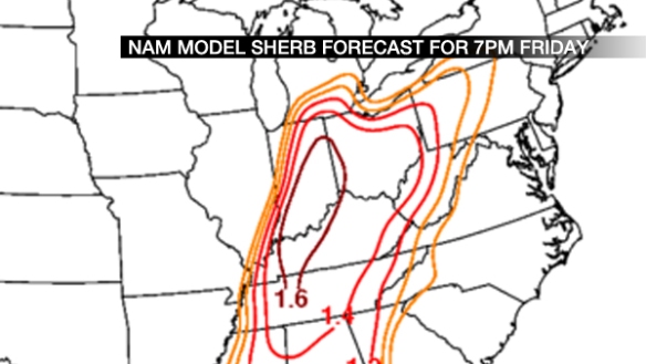
I talked about the SHERB parameter earlier this week in a blog post earlier this week in a blog post; as a review, it has skill in highlighting severe weather areas where there is limited instability and high wind shear (a similar environment to what we have Friday). SHERB values of 1+ signal and elevated threat for severe storms in this mode. Here’s what this morning’s NAM model has for SHERB at 7pm Friday:

feb23-blog-sherbnam

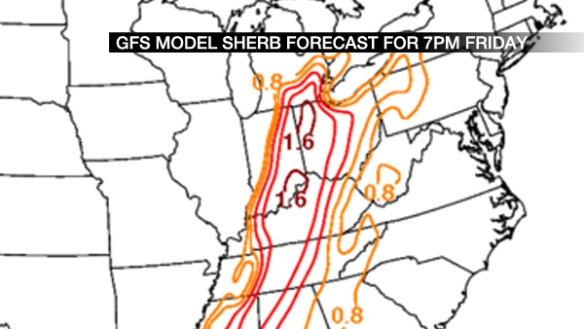
Those values are higher and positioned more to the east than runs earlier this week. Does this morning’s NAM model agree?

feb23-blog-sherbgfs

It does, and these values are not extreme, but high. This suggests confidence is rising in strong or severe storms late Friday.

I could show you additional parameters and signals, but ultimately, you need to know the threats and timing. My latest thinking is below:

impacts

The damaging straight-line wind threat, large hail, and tornado threat have increased since yesterday, but this threat may lower or increase again later today or Friday. Stay alert!

Friday Severe Threat Update

Early Wednesday morning, the Tri-State was placed in a slight to enhanced risk for severe storms for Friday. This should not be a surprise if you saw my blog post from yesterday. The enhanced risk is northwest of Cincinnati, and the rest of the Tri-State is in the slight risk:

feb22-spc

The enhanced risk is the higher risk, and the slight risk is the lower risk.

There will be a main line of rain and storms sweeping through Friday night, but there is also a concern – especially northwest of Cincinnati – for discrete, individual cells or “troublemakers” ahead of the main line late Friday afternoon and early Friday evening. These cells can sometimes be supercellular, but not always. In this case, guidance supports tornadic thunderstorms and supercells over northern and central Indiana, but the threat is more nebulous and conditional in southeastern Indiana.

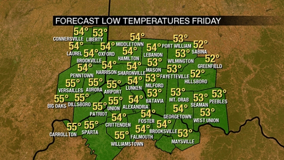
Temperatures will likely be in the mid 50s early Friday morning:

feb22-temps1

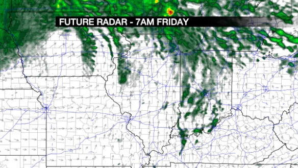
…and the dewpoint will likely be within a couple of degrees of the temperature. Warm, humid air supports the storm threat. Wednesday morning’s NAM model future radar product suggests there will be stray showers – especially northwest of Cincinnati – early Friday morning:

feb22-blog-7amradar

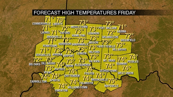
Temperatures will rise into the low and mid 70s Friday afternoon. This kind of warmth fuels storms, especially in February:

feb22-temps2

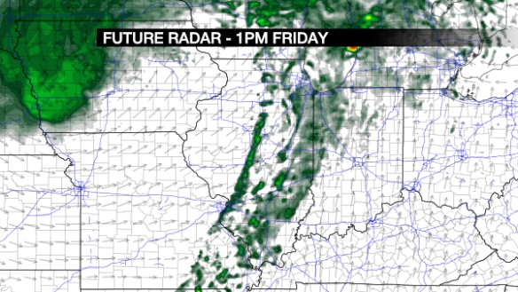
Tuesday morning’s NAM model suggests a line of showers and storms will develop to the west of the Tri-State early Friday afternoon:

feb22-blog-1pmradar

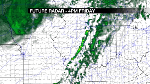
This line is likely to intensify during the afternoon as it pushes east:

feb22-blog-4pmradar

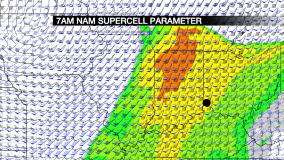
Let’s stop here, and introduce the supercell parameter. What’s that? It’s an index that shows the support for supercell storms and tornadoes. Higher values of the supercell parameter suggest a higher threat for tornadoes, and the NAM model has these high values in northwestern Indiana at 4pm Friday:

feb22-blog-namsp

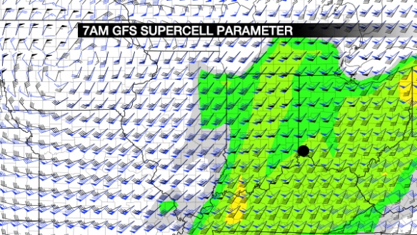
…and a lower, but still significant threat here. The GFS model is not as impressed at 5pm Friday:

feb22-blog-gfssp

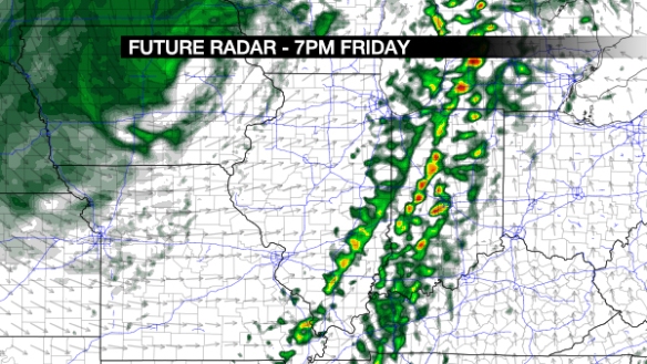
…but it, too, has us in a relatively low threat. Here’s what the NAM model thinks the radar will look like at 7pm Friday:

feb22-blog-7pmradar

The highest radar echoes are still over Indiana, but the line is marching east. This line will gradually weaken as it moves east, but strong and severe storms are still a possibility Friday evening. My overall thinking on the severe threat late Friday is here:

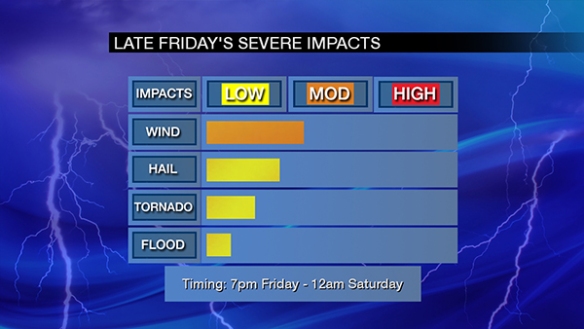
feb22-impacts

Damaging straight-line, large hail, tornadoes, and flooding are late Friday’s severe weather threats, in that order. Stay alert and be prepared!


Let’s Talk About Friday’s Severe Weather Threat

Strong and severe storms on Friday have been a threat in the Ohio Valley since Sunday. That threat is still there, and the Storm Prediction Center has highlighted much of the Ohio Valley and lower Great Lakes in their latest severe weather outlook, which was released before sunrise Tuesday:
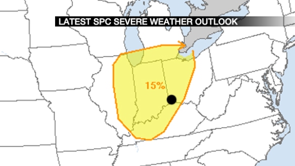
feb21-spc

What does 15% mean? It shows the risk of a severe weather report within 25 miles of point. 15% is the equivalent of a slight risk. The Tri-State is in this risk.

What time am I expecting storms? It depends on which model you believe. Here’s how much thunderstorm-related precipitation Tuesday morning’s NAM model (I’ll just call it NAM from now on) is predicting between 7am and 1pm Friday:
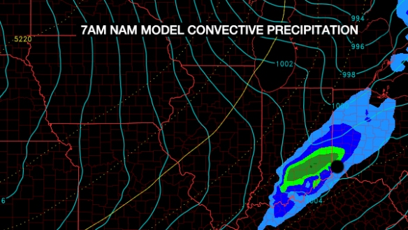
feb21-blog-namprecip

But Tuesday morning’s GFS model (I’ll just call it GFS from now on) is predicting little if any thunderstorm-related precipitation in the Tri-State from 7am to 1pm Friday:
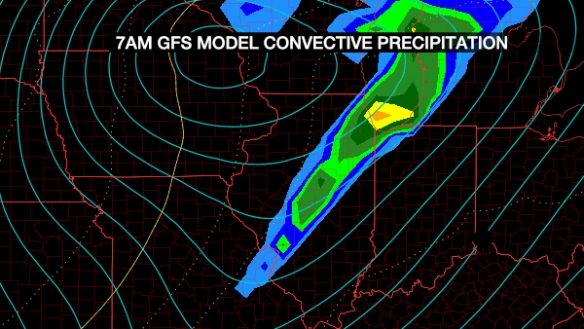
feb21-blog-gfsprecip

Notice the GFS develops the line of rain and storms to the west of the Tri-State Friday morning and early Friday afternoon. It actually has it over the Tri-State Friday evening, between approximately 9pm Friday and 2am Saturday.

Clearly, there are timing differences that need to be worked out. For now, let’s not worry about the timing. Instead, let’s focus on the environment at 1pm Friday for all of the graphics below based on Tuesday morning’s NAM and GFS. Cincinnati is the black dot in all of the graphics below.

Where will the upper-level disturbances be? Remember: when it comes to Friday storms, the NAM is the faster model, and the GFS delays the onset of storms until the evening. Here’s where the disturbances will Friday afternoon per the NAM:
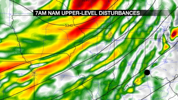
feb21-blog-namvort

The best lift in the atmosphere is on the nose of these disturbances (green, yellow, and red) moving east and northeast. The NAM shows small disturbances over the Ohio Valley (triggering storms) with a bigger disturbance over Wisconsin.

What does the GFS think?
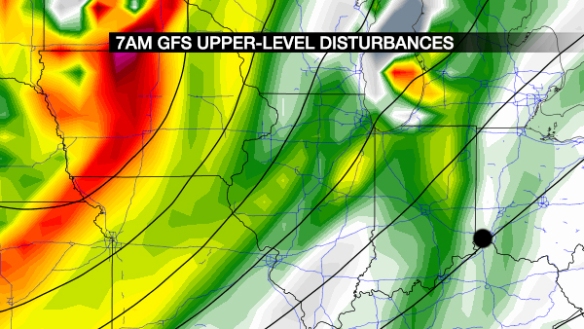
feb21-blog-gfsvort

It has a similar idea to the NAM over the Ohio Valley, but it has the large disturbance to the west farther south larger (deeper red).

Wind fields differ for the NAM and GFS models. The NAM has a strong wind (45-60mph) 5,000 feet over the Ohio Valley Friday afternoon:
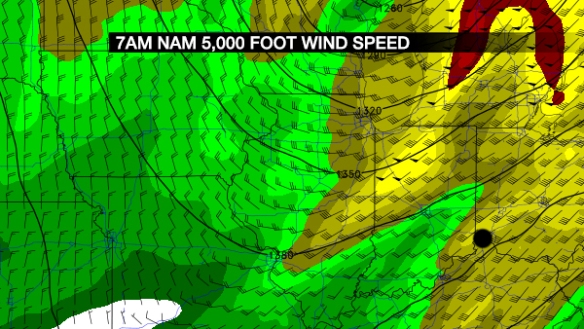
feb21-blog-nam850mbwind

…but the GFS suggests a stronger wind field:

feb21-blog-gfs850mbwind

The red colors are severe wind speeds 5,000 feet above the ground, not at the surface. These strong speeds, however, can be brought down to the ground in heavy rain or strong downdrafts.

A lapse rate is the rate at which temperature decreasing with increasing altitude. High low- and mid-level lapse rates support storms, including strong and severe storms if values are very high. Here are the low-level lapse rates for Friday afternoon from the NAM:
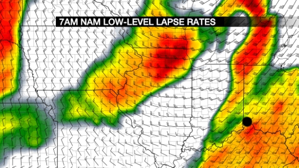
feb21-blog-namlllr2

These are high values. Does the GFS agree?
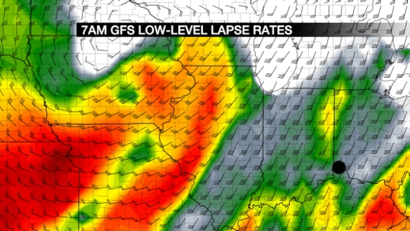
feb21-blog-gfslllr

No, it does not. It strengthens lapse rates slightly late Friday but not to the levels of the NAM at 1pm Friday. How about the mid-level lapse rates? We want those high, too, if we’re getting severe storms. Here’s what the NAM thinks:
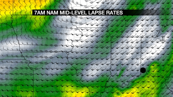
feb21-blog-nammllr

This are okay, but not high. What does the GFS think?
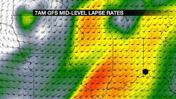
feb21-blog-gfsmllr

These are higher than the NAM. Clearly, there is uncertainty in the strength and timing of the highest lapse rates. The lapse rate is important when assessing storm strength.

How about the SHERB parameter? First, what is SHERB? To review from one of my previous blogs:

While instability can often have a big influence on the chance for thunderstorms, it isn’t as important this time of the year. If thunderstorms are likely […], the SHERB parameter or index can be very helpful to a meteorologist in the colder months when looking a threat for severe weather. The SHERB parameter is helpful for getting a handle on a severe weather threat in the colder months because it focuses on temperature changes near the ground, lift in the atmosphere, and wind shear instead of instability (instability tends to be low in the winter even when we get severe weather).

Why is SHERB important? Unlike summer severe weather events which are driven by high instability and less of everything else, cold season events are driven by everything else and not often by instability. SHERB is a special blend of “everything else” that is important when gauging a severe weather threat…which makes it valuable when we don’t have summer-like heat and humidity. When SHERB values are high and the chance for rain and storms is high, severe weather is often a concern.

Here’s what the NAM thinks for effective (storm-based) SHERB at 1pm Friday:
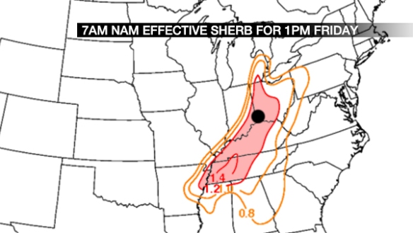
feb21-blog-sherbnam

In low-instability, high wind shear environments (like Friday’s), the SHERB values greater than 1+ often signal support for strong and severe storms. What does the GFS think for SHERB values at 1pm Friday?
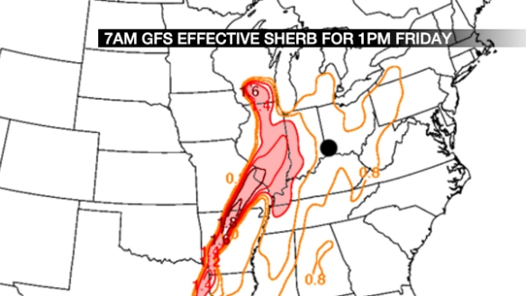
feb21-blog-sherbgfsearly

Again, the GFS develops the line of rain and storms to the west later Friday, whereas the NAM develops them closer to Cincinnati earlier Friday. What does SHERB look like later in the day Friday per the GFS?
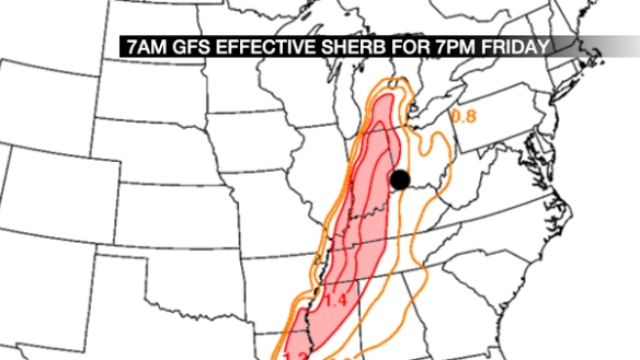
feb21-blog-sherbgfslate

We’re almost in the sweet spot (1+), but most of those values stay west of the Tri-State through Friday night.

Clearly, there are timing and strength issues with Friday storms, but the environment is supportive of strong and severe storms near or west of the Tri-State. The SPC has pinpointed the most likely area for storms well.

Here’s my overall thinking on Friday’s severe threat:
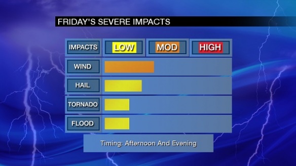
feb21-impacts

The timing is open-ended on purpose…for now.
Update on Tuesday’s Severe Storm Threat

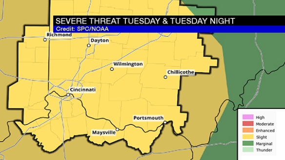
This morning, the Storm Prediction Center placed the entire Tri-State in a slight risk for severe storms on Tuesday and Tuesday evening:

feb5-spc

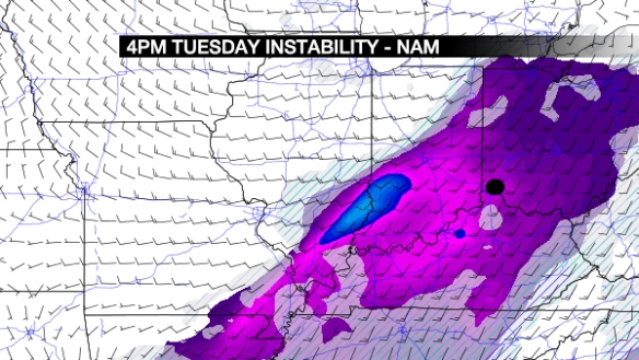
A review of the latest model guidance suggests there will be modest instability (in purple) over the Ohio Valley Tuesday:

feb5-blog-cape

The black dot is Cincinnati. The highest amount of instability will likely be positioned west and southwest of the Tri-State.

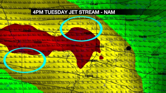
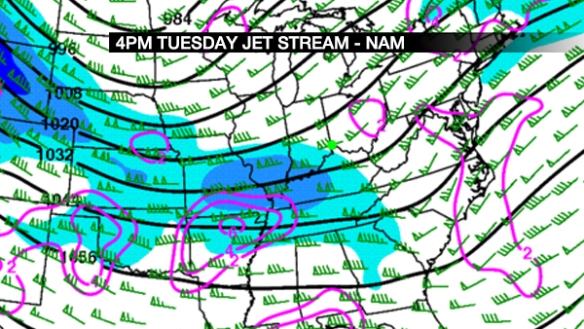
The jet stream will be overhead Tuesday afternoon, with the highest wind speeds to the west of the Tri-State. Favored areas for lift in the atmosphere are highlighted in blue:

feb5-blog-jet

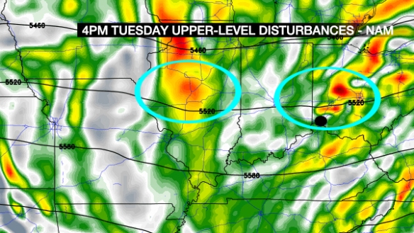
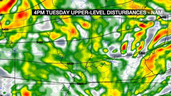
This is not impressive lift over the Tri-State, but it helps. How about the placement of upper-level disturbances? Here’s what Sunday morning’s NAM model things by 4pm Tuesday:

feb5-blog-vort

Disturbances are highlighted in blue. Lift in the atmosphere will be highest ahead of these disturbances (which will move from west to east).

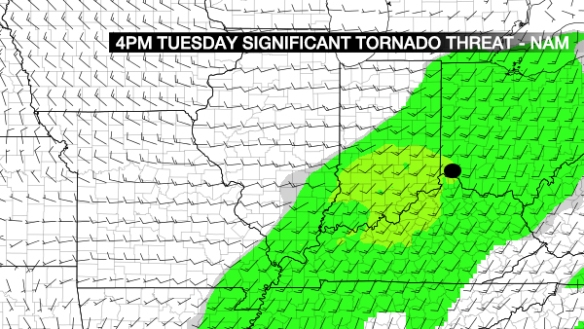
How is the tornado threat looking? Let’s assess this threat using the Significant Tornado Parameter (STP). Values of 1 or highest suggest an elevated risk for tornadoes. Here’s what the NAM projects for STP at 4pm Tuesday:

feb5-blog-stp

Values of 1+  are in light yellow, so there is a risk for tornadoes Tuesday…BUT it is a secondary threat at this time based on review of other data.

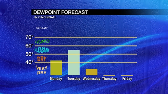
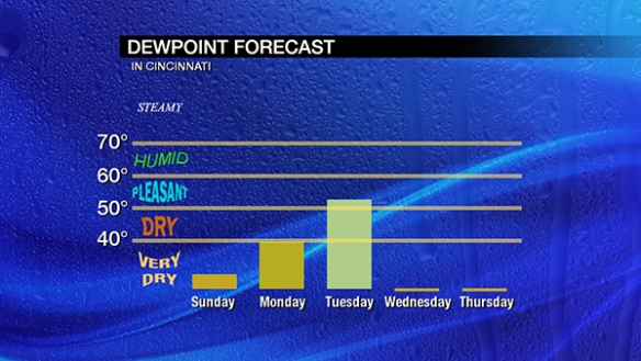
Do we have moisture available to storms? Here’s the dewpoint forecast during the work week:

feb5-dewpoint

We don’t need to be humid in February to get strong or severe storms, but higher dewpoints suggest an increased likelihood for storms. Dewpoints in the mid 50s is high enough to strong strong storms in the cold season.

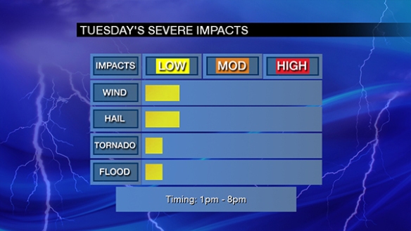
After a review of these parameters and a bunch of other data, the slight risk seems appropriate for Tuesday, with damaging straight-line wind and large hail being the main threats:

feb5-impacts

I’ll update this threat as time permits on Monday and Tuesday.

Severe Storm Threat Tuesday: Knowns & Unknowns

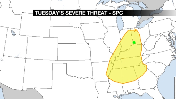
The Storm Prediction Center has placed the Tri-State in a risk for severe storms on Tuesday, highlighted here:

feb1-blog-spc2

For this and all graphics below, Cincinnati is labeled with a green dot. What type of risk is this? Think of it as a “slight” risk for now. A formal classification of “marginal,” “slight,” “enhanced,” “moderate,” or “high” is only used for a given day and the two days that follow it, so we will get the category tomorrow.
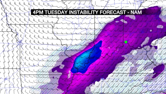
What is contributing to this risk? First, strong or severe storms need access to instability. Warm, moist air at the ground and cold, dry air aloft will help air to rise and create storms. Here’s what Saturday morning’s NAM model thinks for instability at 4pm Tuesday:

feb1-blog-namcape

Modest amounts are in the purple, and higher amounts are in the blue. Even the purple shades can support storms, but other ingredients need to be in place (especially in the colder months of the year) to get thunderstorms.

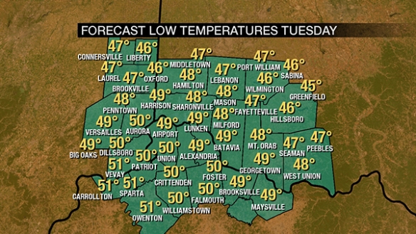
Will it be warm? That’s important. I see temperatures only dropping to near 50° early Tuesday…

feb1-blog-lows

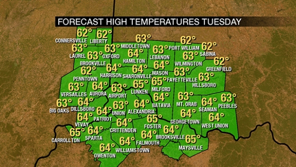
…and rising into the 60s Tuesday afternoon:

feb1-blog-highs

That’s more than warmth enough to see thunderstorms, including strong and severe storms.

How about moisture? Here’s the dewpoint forecast for the next few days:

feb1-dewpoint

We don’t need to be humid this time of the year to get strong or severe storms, but the dewpoint almost always needs to be above 50° to get severe storms in February.

How about lifting mechanisms for the assist? The NAM model (like others) has several compact disturbances (orange/red colors) over the Ohio Valley Tuesday afternoon:

feb1-blog-vort2

…this supports storms, but it’s not impressive lift. How about the jet stream? Here’s what the NAM thinks at 4pm Tuesday:

feb1-blog-jet

Jet stream level wind speeds are in blue, and upper-level divergence of air (promoting lift) are in contours of pruple. There is also lift in the “left-exit” region of the jet streak (part of the jet stream) over the Tri-State. This lift overhead will support storms, but it’s not big time lift.

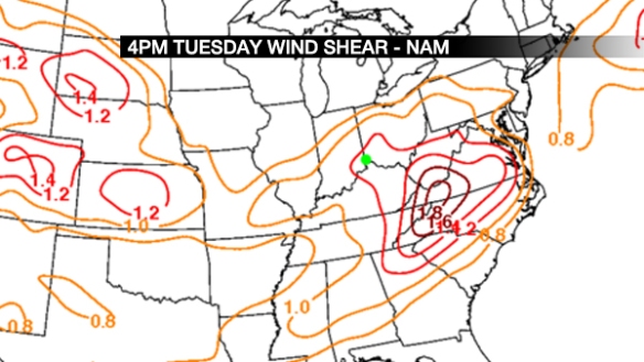
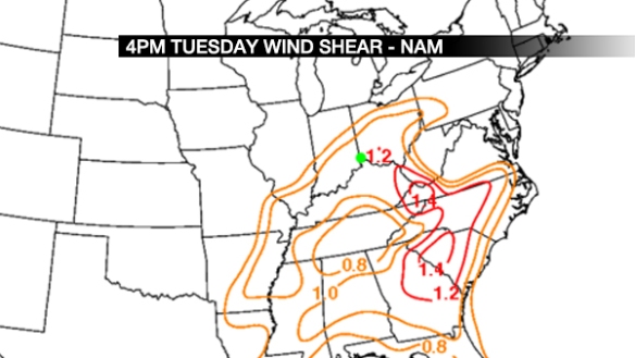
How about wind shear (the change of the wind speed or direction with increasing altitude)? The NAM has plenty of that:

feb1-blog-shear

Remember this is SPEED shear shown here, not directional shear (a lot of the latter supports tornadoes).

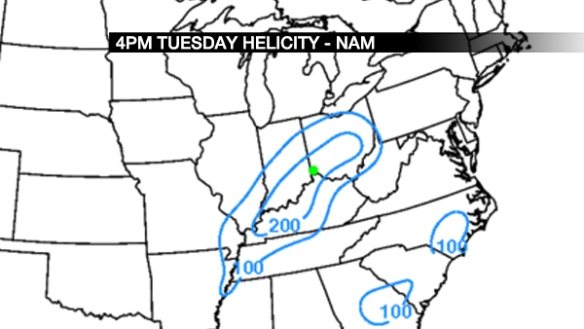
How about helicity (a measure of how likely storms are to rotate)? The NAM has us in a 200 m2/s2 area:

feb1-blog-helicity

What the heck does that number mean? The threshold for what supports severe storms can vary from one season to the other, but this is significant to mention a tornado risk somewhere in the Ohio Valley. Let’s not discuss the level of this risk for now, but instead, acknowledge that this threat should be watched.

How about the SHERB parameter? What’s that? See more on this in this blog post from 2015. This is a helpful parameter in severe weather setups when instability is low. Now that that’s been explained, here’s what the NAM thinks for SHERB at 4pm Tuesday:
feb1-blog-sherb

Any value over 1 with thunderstorms in the area suggests those storms may be strong or severe. How about effective SHERB (in simple terms, SHERB but accounting for storm depth) at 4pm Tuesday?
feb1-blog-sherbe

Again, values are near or just above 1, which supports a strong to severe storm threat.
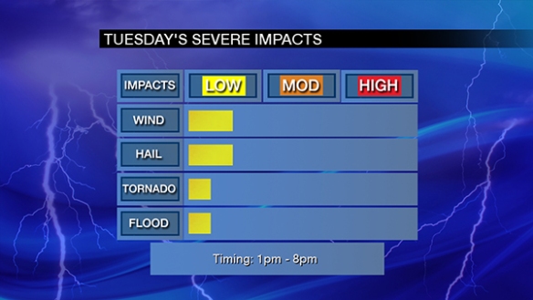
So what do I think about Tuesday’s severe storm threat? Here’s my latest thinking based on the setup and acknowledging uncertainty:

feb1-impacts2

Stay tuned. This threat may change, and new guidance will help to target areas that have a better threat versus other areas.

Snow Likely Thursday

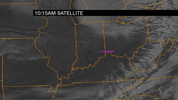
While snow is coming Thursday, the sky will be sunny to mostly sunny this afternoon. A 10:15am cloud snapshot of the Ohio Valley shows some clouds to the northwest moving southeast:

jan4-1015amclouds

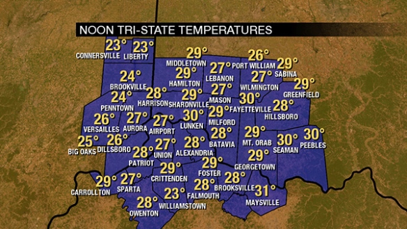
Despite sunshine, it is still cold. As of noon, temperatures are in the mid to upper 20s for most:

jan4-11amtemps

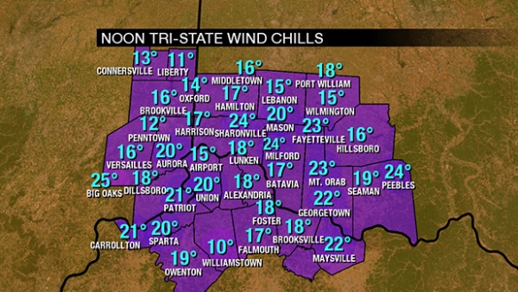
A sustained wind between 10 and 20mph means it feels colder. Wind chills in the Tri-State are in the teens and 20s:

jan4-11amwc

Temperature will barely rise this afternoon thank to a westerly wind dragging cold air in from the Plains and Mississippi:

jan4-afternoon

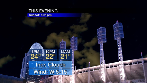
The influence of low pressure will begin tonight in the form of high- and mid-level clouds increasing. Plan for temperatures fall through the 20s:

jan4-evening

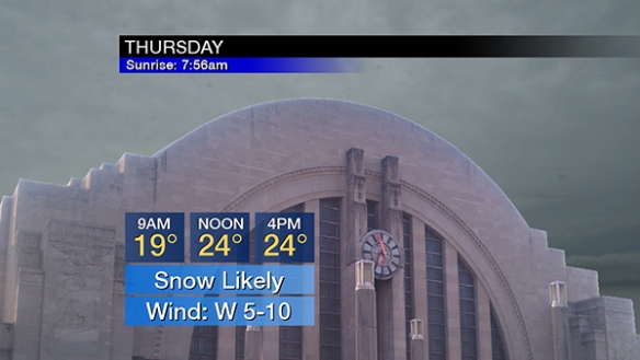
Snow is likely Thursday. The coverage will increase in the morning, be steady for most of the afternoon, and end Thursday evening:

jan4-thursday

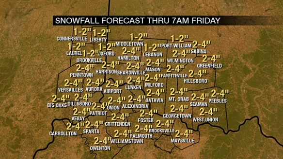
Temperatures in the low to mid 20s will mean snow-to-liquid ratios will be higher than usual. This means that liquid-equivalent precipitation (all forms of precipitation melted down) will need to be multiplied by a factor that is higher than usual. A baseline ratio for temperatures in the upper 20s and low 30s is 10:1. Given that temperatures will be in the low to mid 20s, this snow-to-liquid ratio is more like 18:1. Remember, 10:1 or 18:1 are snow-to-liquid ratios, NOT forecast snow totals. I am explaining the meteorology of taking what forecast models produce to a snow forecast. Models are producing 0.1″ to 0.18″ of liquid for this event (all snow), so totals of 2-4″ totals look appropriate for most, but not all. Here’s what I’m thinking for event total snowfall (Thursday and Thursday night):

jan4-snowfall

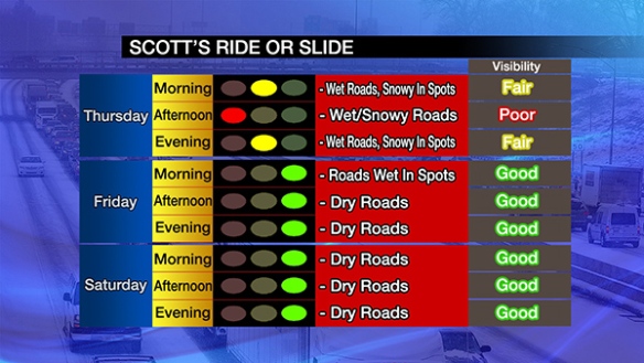
This is a significant increase in amounts compared to 24 hours ago. This will not be a winter storm, per se…but it will be significant winter weather event. Roads will at least be wet on Thursday, and they will likely be snowy in spots with pavement temperatures in the 20s. Snow squalls are unlikely tomorrow, but the visibility will be reduced by snow…especially in the late morning and first half of the afternoon Thursday:

jan4-ride

Red lights for travel conditions are somewhat rare for me. Again, this does not appear to be a winter storm, but impacts will be significant!